
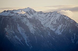
Chikamin Peak is a 6,994-foot (2,132-metre) mountain summit located in the Cascade Range, in Kittitas County of Washington state. It is situated within the Alpine Lakes Wilderness on land managed by the Okanogan–Wenatchee National Forest. The mountain's name "Chikamin" derives from Chinook Jargon meaning "money" or "metal", and was submitted by Edmond S. Meany, president of The Mountaineers. This name was officially adopted in 1916 by the U.S. Board on Geographic Names. Chikamin Peak is the highest point of Chikamin Ridge, six miles (9.7 km) northeast of Snoqualmie Pass. Other notable peaks on Chikamin Ridge include Four Brothers and Three Queens. Precipitation runoff from this mountain drains into tributaries of the Yakima River. The Pacific Crest Trail traverses the southwest slope of Chikamin Ridge, and from the trail a scramble up a gully leads to the summit and several alpine lakes including Chikamin Lake and Spectacle Lake.

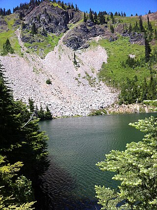
Alta Mountain is a 6,275-foot (1,913-metre) mountain summit located in Kittitas County of Washington state. It is set within the Alpine Lakes Wilderness which is part of the Cascade Range. Alta Mountain is situated on land managed by Wenatchee National Forest. Precipitation runoff from the mountain drains into tributaries of the Yakima River.
Cannon Mountain is an 8,652-foot (2,637 meter) mountain summit located in Chelan County of Washington state. Cannon Mountain is part of The Enchantments, within the Alpine Lakes Wilderness. Cannon Mountain belongs to the Stuart Range which is subset of the Cascade Range. Cannon Mountain is situated one mile north of Enchantment Peak. The nearest higher peak is Dragontail Peak, 2.15 mi (3.46 km) to the southwest. Precipitation runoff from the slopes drains into Icicle Creek, which is a tributary of the Wenatchee River.

Cashmere Mountain is an 8,514-foot (2,595-metre) mountain summit located in Chelan County of Washington state. Cashmere Mountain is situated within the Alpine Lakes Wilderness, on land managed by the Okanogan–Wenatchee National Forest. It is part of the Wenatchee Mountains which are subset of the Cascade Range. The nearest higher neighbor is Cannon Mountain, 4.4 mi (7.1 km) to the southeast. Precipitation runoff from this mountain drains into tributaries of Icicle Creek, which in turn is a tributary of the Wenatchee River.

Hibox Mountain is a 6,550-foot (1,996-metre) mountain summit located in the Cascade Range in Kittitas County of Washington state. It is situated within the Alpine Lakes Wilderness on land managed by Okanogan-Wenatchee National Forest. The mountain's name "Hibox" is a portmanteau which is derived from its position as the high point of Box Ridge. The peak is five miles east of Snoqualmie Pass, and Alta Mountain lies 1.5 miles to the west-northwest of Hibox. Precipitation runoff from the mountain drains into Box Canyon Creek and Mineral Creek which both empty to Kachess Lake. Topographic relief is significant as the summit rises 3,250 feet above Box Canyon in one mile (1.6 km).

Big Chiwaukum is a prominent 8,098-foot (2,468-metre) mountain in Chelan County, Washington, United States. Big Chiwaukum is located northeast of Frosty Pass, and within the Alpine Lakes Wilderness. Big Chiwaukum is the highest peak in the Chiwaukum Mountains, a subset of the Cascade Range. The nearest higher peak is Cashmere Mountain, 10.35 mi (16.66 km) to the south-southeast. Precipitation runoff from Big Chiwaukum drains into tributaries of the Wenatchee River. In the Wenatchee dialect, Chiwaukum means many little creeks running into one big one.

The Cradle is a prominent 7,472-foot (2,277-metre) double summit mountain located in Chelan County of Washington state. The mountain's name is derived from the depression between the two peaks of nearly identical elevation. The Cradle is situated within the Alpine Lakes Wilderness and is part of the Wenatchee Mountains, which is subset of the Cascade Range. Its nearest higher peak is Jack Ridge, 5.7 mi (9.2 km) to the east-southeast. Precipitation runoff from the mountain drains into tributaries of Icicle Creek, which in turn is a tributary of the Wenatchee River. The first ascent of the south peak was made in 1944 by Gene Paxton and Dwight Watson, whereas the north peak wasn't climbed until 1952 by Bill and Gene Prater.

Rampart Ridge is a 5,870 ft (1,790 m) elevation mountain ridge located in the Cascade Range, in Kittitas County of Washington state. It is situated northeast of Hyak, Washington, and the north end of Keechelus Lake, within the Alpine Lakes Wilderness, on land managed by Wenatchee National Forest. Its nearest higher peak is Alta Mountain, 1.74 mi (2.80 km) to the north-northeast, and Dungeon Peak rises 0.77 mi (1.24 km) to the south-southwest. The north-south trending ridge is characterized by vertical cliffs on its west-facing side above the Gold Creek valley, and gentle meadows with lakes on the eastern side, such as Rachel Lake, Lake Lillian, and the Rampart Lakes. The descriptive name of rampart was officially adopted 1918 by the United States Board on Geographic Names based on a suggestion by The Mountaineers. Precipitation runoff from the ridge drains into tributaries of the Yakima River.

Alaska Mountain is a 5,745-foot (1,751-metre) mountain summit located in the Cascade Range, in Kittitas County of Washington state. It is situated within the Alpine Lakes Wilderness on land managed by Wenatchee National Forest. Alaska Mountain is set between Alaska Lake and Joe Lake, 8 miles (13 km) northeast of Snoqualmie Pass, and 0.81 miles (1.30 km) southeast of Mount Thomson, which is also its nearest higher peak. The Pacific Crest Trail traverses around the south, east and north slopes of Alaska Mountain, and an off-trail hike leads to the summit. Precipitation runoff on the east side of the mountain drains into tributaries of the Yakima River, whereas the west side of the peak drains into tributaries of the Snoqualmie River.

Cathedral Rock 6,724-foot (2,049-metre) mountain located in the Cascade Range, in Kittitas County of Washington state. It is situated within the Alpine Lakes Wilderness, on land managed by Wenatchee National Forest. Its nearest higher peak is The Citadel, 1.7 mi (2.7 km) to the southwest, and the dominant mountain in the area, Mount Daniel, rises 2.2 mi (3.5 km) to the west-northwest. Precipitation runoff from the peak drains into tributaries of the Yakima River.

Four Brothers is a 6,485-foot-elevation (1,977-meter) mountain summit located in Kittitas County of Washington state.

Surprise Mountain is a 6,330-foot (1,929-metre) mountain summit located above the southern end of Glacier Lake, in eastern King County of Washington state. It is part of the Wenatchee Mountains, which are a subset of the Cascade Range, and is situated in the Alpine Lakes Wilderness, on land managed by Mount Baker-Snoqualmie National Forest. Precipitation runoff from the mountain drains into Surprise Creek and Deception Creek, both tributaries of the Skykomish River. The nearest higher neighbor is Thunder Mountain, 0.88 mi (1.42 km) to the northeast, and Terrace Mountain is set three miles (4.8 km) to the southwest. The Pacific Crest Trail skirts this peak as it passes through Surprise Gap.

Thunder Mountain is a 6,556-foot (1,998-metre) mountain summit located above the eastern shore of Glacier Lake, on the common border of King County and Chelan County in Washington state. It's part of the Wenatchee Mountains, which are a subset of the Cascade Range, and is situated in the Alpine Lakes Wilderness, on land managed by Mount Baker-Snoqualmie National Forest. Precipitation runoff from the mountain drains west into Surprise Creek, or east into tributaries of Icicle Creek. The nearest higher neighbor is Nimbus Mountain, 0.56 mi (0.90 km) to the northeast, and Surprise Mountain is set 0.88 mi (1.42 km) to the southwest. The Pacific Crest Trail skirts this peak as it passes between Thunder Mountain and Spark Plug Mountain.

Eightmile Mountain is a 7,996-foot (2,437-metre) mountain summit located in Chelan County of Washington state. Eightmile Mountain is situated within the Alpine Lakes Wilderness, on land managed by the Okanogan–Wenatchee National Forest. It is part of the Wenatchee Mountains which are a subset of the Cascade Range. Its nearest higher neighbor is Cashmere Mountain, 3 mi (4.8 km) to the northeast, and Mount Stuart rises 4 mi (6.4 km) to the south. Precipitation runoff from the mountain drains into Trout Creek and Eightmile Creek, both tributaries of Icicle Creek, which in turn is a tributary of the Wenatchee River. This mountain is known for its spring skiing and excellent view of the Stuart Range.

Granite Mountain is a 7,144-foot (2,177-metre) double summit mountain located 11.5 mi (18.5 km) south of Stevens Pass on the common border of Kittitas County and Chelan County in Washington state. It's part of the Wenatchee Mountains, which are a subset of the Cascade Range, and is situated 19 mi (31 km) west of Leavenworth in the Alpine Lakes Wilderness, on land managed by the Okanogan–Wenatchee National Forest. Granite Mountain is the highest point on the Hyas Lake-French Creek divide with precipitation runoff from the mountain draining west into Cle Elum River, or east into French Creek, a tributary of Icicle Creek. Its subsidiary 7,080-ft South Peak is positioned half a mile to the south-southeast, the nearest higher neighbor is The Cradle, 3 mi (4.8 km) to the southeast, and Mac Peak is set 3.6 mi (5.8 km) to the north-northwest. The Pacific Crest Trail skirts below the western base this peak.

Trico Mountain is a 6,640+ ft mountain summit located 10 mi (16 km) south of Stevens Pass on the common border of King County, Kittitas County and Chelan County in Washington state. "Trico" is a portmanteau of triple county. This peak is part of the Wenatchee Mountains, which are a subset of the Cascade Range, and is situated 20 mi (32 km) west of Leavenworth in the Alpine Lakes Wilderness. Trico is a triple divide peak with precipitation runoff from the mountain draining south into Cle Elum River, northwest into Deception Creek, and northeast into Leland Creek, which is a tributary of Icicle Creek. The scenic Tuck and Robin Lakes are set on the south slopes, between Trico and Granite Mountain, which is 1.6 mi (2.6 km) to the southeast. The Pacific Crest Trail skirts below the western aspect this peak as it crosses Deception Pass.

Arrowhead Mountain is a 6,030 ft (1,840 m) mountain summit located in Chelan County of Washington state. It is situated 6 mi (9.7 km) east of Stevens Pass, on the boundary of Alpine Lakes Wilderness, on land managed by the Okanogan–Wenatchee National Forest. Arrowhead Mountain is part of the Chiwaukum Mountains, which are a subset of the Cascade Range. Its nearest higher neighbor is Jim Hill Mountain, 2.5 mi (4.0 km) to the southwest. Precipitation runoff from the peak drains into tributaries of Nason Creek, which in turn is a tributary of the Wenatchee River. This mountain was named by Albert Hale Sylvester (1871–1944), a pioneering surveyor, explorer, topographer, and forest supervisor who named hundreds of natural features in the Cascades.

Three Queens is a prominent 6,693-foot (2,040-metre) triple-summit mountain located in the Cascade Range, in Kittitas County of Washington state. It is set within the Alpine Lakes Wilderness on land managed by Wenatchee National Forest. The East Peak is the highest, and its subpeaks are the Middle Peak, and West Peak. Three Queens is set 6.5 miles (10.5 km) east-northeast of Snoqualmie Pass, on Chikamin Ridge, 2.76 miles (4.44 km) southeast of its nearest higher neighbor, Chikamin Peak. The Pacific Crest Trail traverses the west slope of Three Queens as it crosses the gap between Four Brothers and Three Queens. Precipitation runoff from the mountain drains into tributaries of the Yakima River drainage basin. The first ascent was likely made in 1925 by a party of eight Mountaineers led by Glen Bremerman and C. A. Fisher. This mountain's toponym was officially adopted in 1940 by the United States Board on Geographic Names.

Big Lou is a 7,780+ ft mountain summit located in Chelan County of Washington state. It is situated 8.5 mi (13.7 km) west-northwest of Leavenworth, on the boundary of the Alpine Lakes Wilderness, and on land managed by the Okanogan–Wenatchee National Forest. Big Lou is the highest point on Icicle Ridge, and is the third-highest peak in the Chiwaukum Mountains, a subset of the Cascade Range. Its nearest higher neighbor is Snowgrass Mountain, 5 mi (8.0 km) to the northwest, and slightly lower Big Jim Mountain is set 1.75 mi (2.82 km) to the north-northeast. Precipitation runoff from Big Lou drains into Icicle Creek and other tributaries of the Wenatchee River. Although modest in elevation, relief is significant since Big Lou rises 5,200 feet above Icicle Creek Valley in approximately two miles. Big Lou is named for mountaineer Lou Whittaker, the twin brother of Jim Whittaker, the first American to summit Mount Everest.
Mount Margaret is a 5,850-ft mountain summit located in the Wenatchee National Forest, in the Alpine Lakes Wilderness, in Kittitas County of Washington state. It is situated in the Cascade Range, 4.5 mi (7.2 km) east of Interstate 90, and on the south aspect of Rampart Ridge. Its nearest higher neighbor is Alta Mountain, 4.93 mi (7.93 km) to the north. Keechelus Lake is a short distance west and Kachess Lake further east.


