
A suspension bridge is a type of bridge in which the deck is hung below suspension cables on vertical suspenders. The first modern examples of this type of bridge were built in the early 1800s. Simple suspension bridges, which lack vertical suspenders, have a long history in many mountainous parts of the world.

Nenana (Lower Tanana: Toghotili; is a home rule city in the Yukon-Koyukuk Census Area of the Unorganized Borough in the Interior of the U.S. state of Alaska. Nenana developed as a Lower Tanana community at the confluence where the tributary Nenana River enters the Tanana. The population was 378 at the 2010 census, down from 402 in 2000.

The George Washington Bridge is a double-decked suspension bridge spanning the Hudson River, connecting Fort Lee in Bergen County, New Jersey, with Upper Manhattan in New York City. It is named after George Washington, the first president of the United States. The George Washington Bridge is the world's busiest motor vehicle bridge, carrying a traffic volume of over 104 million vehicles in 2019, and is the world's only suspension bridge with 14 vehicular lanes as of 2012. It is owned by the Port Authority of New York and New Jersey, a bi-state government agency that operates infrastructure in the Port of New York and New Jersey. The George Washington Bridge is also informally known as the GW Bridge, the GWB, the GW, or the George, and was known as the Fort Lee Bridge or Hudson River Bridge during construction. The George Washington Bridge measures 4,760 feet (1,450 m) long and has a main span of 3,500 feet (1,100 m). It was the longest main bridge span in the world from its 1931 opening until the Golden Gate Bridge in San Francisco opened in 1937.

The Trans-Alaska Pipeline System (TAPS) is an oil transportation system spanning Alaska, including the trans-Alaska crude-oil pipeline, 11 pump stations, several hundred miles of feeder pipelines, and the Valdez Marine Terminal. TAPS is one of the world's largest pipeline systems. The core pipeline itself, which is commonly called the Alaska pipeline, trans-Alaska pipeline, or Alyeska pipeline,, is an 800-mile (1,287 km) long, 48-inch (1.22 m) diameter pipeline that conveys oil from Prudhoe Bay, on Alaska's North Slope, south to Valdez, on the shores of Prince William Sound in southcentral Alaska. The crude oil pipeline is privately owned by the Alyeska Pipeline Service Company.
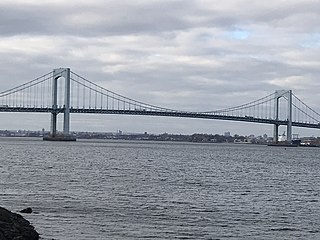
The Throgs Neck Bridge is a suspension bridge in New York City, carrying six lanes of Interstate 295 (I-295) over the East River where it meets the Long Island Sound. The bridge connects the Throggs Neck section of the Bronx with the Bay Terrace section of Queens.
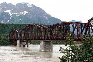
The Miles Glacier Bridge, also known as the Million Dollar Bridge, was built in the early 1900s across the Copper River fifty miles from Cordova in what is now the U.S. state of Alaska. It is a multiple-span Pennsylvania truss bridge which completed a 196-mile (315 km) railroad line for the Copper River and Northwestern Railway, built by J. P. Morgan and the Guggenheim family to haul copper from the old mining town of Kennicott, now located within the Wrangell–St. Elias National Park and Preserve, to the port of Cordova. It earned its nickname because of its $1.4 million cost, well recouped by the about $200 million worth of copper ore which was shipped as a result of its construction.

The James W. Dalton Highway, usually referred to as the Dalton Highway, is a 414-mile (666 km) road in Alaska. It begins at the Elliott Highway, north of Fairbanks, and ends at Deadhorse near the Arctic Ocean and the Prudhoe Bay Oil Fields. Once called the North Slope Haul Road, it was built as a supply road to support the Trans-Alaska Pipeline System in 1974. It is named after James Dalton, a lifelong Alaskan and an engineer who supervised construction of the Distant Early Warning Line in Alaska and, as an expert in Arctic engineering, served as a consultant in early oil exploration in northern Alaska. It is also the subject of the second episode of America's Toughest Jobs and the first episode of the BBC's World's Most Dangerous Roads.

The Bronx–Whitestone Bridge is a suspension bridge in New York City, carrying six lanes of Interstate 678 over the East River. The bridge connects Throggs Neck and Ferry Point Park in the Bronx, on the East River's northern shore, with the Whitestone neighborhood of Queens on the southern shore.

The Alaska Railroad is a Class II railroad that operates freight and passenger trains in the state of Alaska. The railroad's mainline runs between Seward on the southern coast and Fairbanks, near the center of the state. It passes through Anchorage and Denali National Park, to which 17% of visitors travel by train.
The Fairbanks Daily News-Miner is a morning daily newspaper serving the city of Fairbanks, Alaska, the Fairbanks North Star Borough, the Denali Borough, and the Yukon-Koyukuk Census Area in the U.S. state of Alaska. It is the farthest north daily in the United States, and one of the farthest north in the world. The oldest continuously operating daily in Alaska, by circulation it is the second-largest daily in the state. It was purchased by the Helen E. Snedden Foundation in 2016. The Snedden family were longtime owners of the News-Miner, selling it to a family trust for Dean Singleton and Richard Scudder, founders of the Media News Group in 1992.
Five Mile Airport is a private-use airport located in Five Mile in the U.S. state of Alaska. The airport is owned by the United States Bureau of Land Management (BLM) - Pipeline Office and managed by the Alyeska Pipeline Company. It is also known as Five Mile Camp Airport.
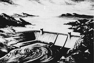
The Rampart Dam or Rampart Canyon Dam was a project proposed in 1954 by the U.S. Army Corps of Engineers to dam the Yukon River in Alaska for hydroelectric power. The project was planned for Rampart Canyon just 31 miles (50 km) southwest of the village of Rampart, Alaska, about 105 miles (169 km) west-northwest of Fairbanks.

The history of Fairbanks, the second-largest city in Alaska, can be traced to the founding of a trading post by E.T. Barnette on the south bank of the Chena River on August 26, 1901. The area had seen human occupation since at least the last ice age, but a permanent settlement was not established at the site of Fairbanks until the start of the 20th century.
The construction of the Trans-Alaska Pipeline System included over 800 miles (1,300 km) of oil pipeline, 12 pump stations, and a new tanker port. Built largely on permafrost during 1975–77 between Prudhoe Bay and Valdez, Alaska, the $8 billion effort required tens of thousands of people, often working in extreme temperatures and conditions, the invention of specialized construction techniques, and the construction of a new road, the Dalton Highway.
Marvin Dale Mangus (1924–2009) was an American geologist and landscape painter. He was giving the honor of driving a purely symbolic wood stake prior to start of drilling the actual oil well by the Atlantic Richfield Corporation, his employer. The focus of his later art career was glorified role of geologist and other exploration of Alaska. He painted animals and birds and was recognized with awards from The National Park Service
Seward's Success was a planned community proposed for Point MacKenzie, north of Anchorage, Alaska, United States. The megaproject was to be fully enclosed by a dome spanning the Knik Arm and holding a community of 40,000 residents, with ample residential, office, recreational and commercial space. It was proposed in 1968 after the discovery of oil at Prudhoe Bay and scuttled in 1972 by a delay to the development of the Trans-Alaska Pipeline System.

The John O'Connell Bridge is a cable-stayed bridge over the Sitka Channel located in Sitka, Alaska. The bridge connects the town of Sitka on Baranof Island to the airport and Coast Guard Station on Japonski Island. Until the bridge was completed in 1971, the commute was only achievable through a ferry service. The bridge is named after John W. O'Connell, a former mayor of Sitka. The two-lane bridge is 1,255 feet (383 m) in total length, with a main span of 450 feet (140 m). The bridge was also the United States' first vehicular cable-stayed girder spanned bridge. The four 100-foot-high (30 m) steel pylons carry two three-cable sets, each carrying a section of the bridge deck. Special consideration was given to the bridge's aesthetics due to its proximity to nearby Castle Hill.

The Grand Street Bridge was a double-leaf deck-girder bascule bridge in Bridgeport, Connecticut, United States, that spanned the Pequonnock River and connected Grand Street and Artic Street. It was one of three movable bridges planned by the City of Bridgeport in 1916 at the request of the War Department during World War I. Construction was completed in 1919, but the delays surrounding the construction went to the Connecticut Supreme Court in case of Edward DeV. Tompkins, Inc. vs. City of Bridgeport, Connecticut. The court ruled in favor of Tompkins and awarded damages equal to the contract. In 1936, the bridge had excessive settling and required the replacement of its southeast pier. As part of the repairs, a new floor and electrical system were installed. In 1965, the floor was replaced with a steel grate on I-beam floor. In 1984, the eastern approach span was replaced and the northwest trunnion post was reconstructed. The bridge was closed in the 1990s and dismantled in 1999.

The Captain William Moore Bridge is an historic 300-foot (91 m) asymmetric single-pylon cable-stayed bridge on the Klondike Highway that spans the Moore Creek Gorge in the borough of Skagway, Alaska, United States, about 17 miles (27 km) north of the city of Skagway. Before the bridge was built in 1976, Whitehorse, Yukon, was only accessible from Skagway by the White Pass and Yukon Route railroad. The bridge connects Skagway to the Yukon highway network and allows traffic to pass over the Moore Creek Gorge, which flows along a fault line. To minimize bridge damage from earthquake movements along the fault line, the bridge was designed with anchors only at one end, which in this case was the south bank. Over the decades, heavy ore truck traffic weakened the bridge. In 2019 a replacement buried bridge located 150 feet west of the historic bridge was opened, and the 1976 cable-stayed bridge was repurposed as a pedestrian viewpoint and wayside historic attraction.
It's historic and beautiful, and is the only cantilevered cable-stayed bridge in Alaska...

