Eagle Harbor, Maryland

Last updated

Eagle Harbor, Maryland
Seal of Eagle Harbor, Maryland.png
Prince George's County Maryland Incorporated and Unincorporated areas Eagle Harbor Highlighted.svg
Location of Eagle Harbor, Maryland
Coordinates: 38°34′0″N76°41′13″W / 38.56667°N 76.68694°W / 38.56667; -76.68694
Country Flag of the United States.svg United States
State Flag of Maryland.svg  Maryland
County Flag of Prince George's County, Maryland (1963-present).svg Prince George's
Incorporated 1929 [1]
Area
[2]
  Total0.12 sq mi (0.32 km2)
  Land0.12 sq mi (0.32 km2)
  Water0.00 sq mi (0.00 km2)
Elevation
13 ft (4 m)
Population
 (2020)
  Total67
  Density549.18/sq mi (211.70/km2)
Time zone UTC-5 (Eastern (EST))
  Summer (DST) UTC-4 (EDT)
ZIP code
20608
Area code(s) 301, 240
FIPS code 24-24200
GNIS feature ID0597360
Website www.townofeagleharborincmd.org

Eagle Harbor is an incorporated town in the far southeast corner of Prince George's County, Maryland, United States, and near the rural community of Aquasco that is known as a historic African American community founded in 1925. [3] [4] Per the 2020 census, the population was 67. [5] The Chalk Point Generating Station, owned by NRG Energy, which was sold to Mirant by the Potomac Electric Power Company (PEPCO) in 2000, [6] is located adjacent to the town.

Contents

Geography

Eagle Harbor is located at 38°34′0″N76°41′13″W / 38.56667°N 76.68694°W / 38.56667; -76.68694 (38.566709, -76.686841). [7]

According to the United States Census Bureau, the town has a total area of 0.12 square miles (0.31 km2), all land. [8]

Climate

The climate in this area is characterized by hot, humid summers and generally mild to cool winters. According to the Köppen Climate Classification system, Eagle Harbor has a humid subtropical climate, abbreviated "Cfa" on climate maps. [9]

History

Eagle Harbor was originally known as Trueman Point, a river port established in the early 18th century to serve as a shipping point for tobacco plantations located in the Aquasco area. In 1747, it was considered by the Maryland colony as an official tobacco inspection station, but it never realized that designation. In 1817, George Weems established the Weems Steamboat Company, connecting Trueman Point to other landings along the Patuxent River. He also built a tobacco warehouse, and ships routinely stopped at Trueman Landing. The steamboat traffic continued into the 1930s. [10] Trueman Point Landing is a local historic site identified by the Maryland-National Capital Park and Planning Commission. [10] [11]

Located just 30 miles (48 km) from Washington, D.C., in 1925, developer Walter L. Bean purchased land adjoining Trueman Point with the vision of creating a resort community for middle-class African Americans from the area. Lots were offered for $50.00 or less, and the community was advertised as "a high class summer colony for the better people." [10] After a number of summer cottages were constructed, the community incorporated as the town of Eagle Harbor in 1929.

Demographics

Historical population
CensusPop.Note
1930 3
1940 2−33.3%
1950 7250.0%
1960 15114.3%
1970 14−6.7%
1980 45221.4%
1990 38−15.6%
2000 5544.7%
2010 6314.5%
2020 676.3%
U.S. Decennial Census [12]
2010 [13] 2020 [14]

2020 census

Eagle Harbor town, Maryland – Racial and ethnic composition
Note: the US Census treats Hispanic/Latino as an ethnic category. This table excludes Latinos from the racial categories and assigns them to a separate category. Hispanics/Latinos may be of any race.
Race / Ethnicity (NH = Non-Hispanic)Pop 2010 [13] Pop 2020 [14] % 2010% 2020
White alone (NH)5197.94%28.36%
Black or African American alone (NH)583592.06%52.24%
Native American or Alaska Native alone (NH)000.00%0.00%
Asian alone (NH)000.00%0.00%
Pacific Islander alone (NH)000.00%0.00%
Some Other Race alone (NH)010.00%1.49%
Mixed Race or Multi-Racial (NH)080.00%11.94%
Hispanic or Latino (any race)040.00%5.97%
Total6367100.00%100.00%

2010 census

As of the census [15] of 2010, there were 63 people, 22 households, and 16 families living in the town. The population density was 525.0 inhabitants per square mile (202.7/km2). There were 58 housing units at an average density of 483.3 per square mile (186.6/km2). The racial makeup of the town was 7.9% White and 92.1% African American.

There were 22 households, of which 27.3% had children under the age of 18 living with them, 50.0% were married couples living together, 22.7% had a female householder with no husband present, and 27.3% were non-families. 13.6% of all households were made up of individuals. The average household size was 2.86 and the average family size was 3.38.

The median age in the town was 47.8 years. 28.6% of residents were under the age of 18; 1.6% were between the ages of 18 and 24; 14.3% were from 25 to 44; 39.6% were from 45 to 64; and 15.9% were 65 years of age or older. The gender makeup of the town was 50.8% male and 49.2% female.

2000 census

As of the census [16] of 2000, there were 55 people, 24 households, and 15 families living in the town. The population density was 474.9 inhabitants per square mile (183.4/km2). There were 56 housing units at an average density of 483.5 per square mile (186.7/km2). The racial makeup of the town was 30.91% White, 65.45% African American, 1.82% Native American, and 1.82% from two or more races.

There were 24 households, out of which 16.7% had children under the age of 18 living with them, 29.2% were married couples living together, 29.2% had a female householder with no husband present, and 37.5% were non-families. 37.5% of all households were made up of individuals, and 20.8% had someone living alone who was 65 years of age or older. The average household size was 2.29 and the average family size was 3.00.

In the town, the population was spread out, with 21.8% under the age of 18, 5.5% from 18 to 24, 20.0% from 25 to 44, 36.4% from 45 to 64, and 16.4% who were 65 years of age or older. The median age was 46 years. For every 100 females, there were 89.7 males. For every 100 females age 18 and over, there were 79.2 males.

The median income for a household in the town was $58,750, and the median income for a family was $65,625. Males had a median income of $80,138 versus $20,417 for females. The per capita income for the town was $16,255. There were 15.4% of families and 22.4% of the population living below the poverty line, including 56.3% of under eighteens and none of those over 64.

Government

Prince George's County Police Department District 5 Station in Clinton CDP serves the community. [17]

Transportation

Trueman Point Road, the largest road in Eagle Harbor 2018-10-17 12 47 33 View southwest along Trueman Point Road at Patuxent Boulevard in Eagle Harbor, Prince George's County, Maryland.jpg
Trueman Point Road, the largest road in Eagle Harbor

The only method of transportation to Eagle Point is by road. No state highways serve the town. The main road within Eagle Harbor is Trueman Point Road. Ending at Trueman Point along the Patuxent River, it extends southwest, becoming Eagle Harbor Road, and connects with Maryland Route 381.

Education

Residents who live in Eagle Harbor are zoned to Prince George's County Public Schools: [18]

Related Research Articles

<span class="mw-page-title-main">Beltsville, Maryland</span> CDP in Maryland, United States

Beltsville is a census-designated place (CDP) in northern Prince George's County, Maryland, United States. The community was named for Truman Belt, a local landowner. The 2020 census counted 20,133 residents. Beltsville includes the unincorporated community of Vansville.

<span class="mw-page-title-main">Bladensburg, Maryland</span> Town in Maryland, United States

Bladensburg is a town in Prince George's County, Maryland, United States. The population was 9,657 at the 2020 census. Areas in Bladensburg are located within ZIP code 20710. Bladensburg is 8.6 miles (13.8 km) from Washington, D.C.

<span class="mw-page-title-main">Brentwood, Maryland</span> Town in Prince Georges County, Maryland, US

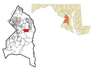
Brentwood is a town in Prince George's County, Maryland, United States. Per the 2020 census, the population was 3,828. Brentwood is located within 1-mile (1.6 km) of Washington. The municipality of Brentwood is located just outside the northeast boundary of the District of Columbia and surrounded by the communities of Mount Rainier, Cottage City, North Brentwood, and the nearby Hyattsville. Along the Route 1 Corridor, Brentwood is part of the Gateway Arts District.

<span class="mw-page-title-main">Camp Springs, Maryland</span> Census-designated place in Maryland

Camp Springs is an unincorporated area and census-designated place (CDP) in Prince George's County, Maryland, United States. The population was 22,734 at the 2020 census. Camp Springs is not an official post office designation; the area is divided among the surrounding mailing addresses of Temple Hills, Fort Washington, Clinton, and Suitland.

<span class="mw-page-title-main">Cheverly, Maryland</span> Town in Prince Georges County, Maryland, US

Cheverly is a town in Prince George's County, Maryland, United States, located very close to Washington, D.C., though not bordering it directly. The town was founded in 1918 and incorporated in 1931. Per the 2020 census, the population was 6,170. Cheverly borders the communities of Tuxedo, Chapel Oaks, Landover, Landover Hills, Villa Heights, and Bladensburg.

<span class="mw-page-title-main">Colmar Manor, Maryland</span> Town in Maryland

Colmar Manor is a town located in Prince George's County, Maryland, United States. As of the 2010 census, the town had a population of 1,404. As the town developed at the beginning of the 20th century, it assumed a name derived from its proximity to the District of Columbia—the first syllable of Columbia and that of Maryland were combined to form "Colmar". Colmar Manor was incorporated in 1927.

<span class="mw-page-title-main">Cottage City, Maryland</span> Town in Maryland, U.S.

Cottage City, officially the Town of Cottage City, is a town in Prince George's County, Maryland, United States. Per the 2020 census, the population was 1,335. Cottage City is a small, quiet community lying between Eastern Avenue, Brentwood, Colmar Manor, and the Anacostia River. Cottage City was developed, beginning in 1870, under the name of "The Highlands". The area was incorporated in 1924 as Cottage City.

<span class="mw-page-title-main">Fairmount Heights, Maryland</span> Historic district in Maryland, United States

Fairmount Heights is a town in Prince George's County, Maryland, United States. Per the 2020 census, the population was 1,528. The town was formally incorporated in 1935, making the town the second oldest African-American-majority municipality in Prince George's County. The town is composed of six subdivisions: Fairmount Heights (1900), Waterford (1907), Mount Weissner (1909), North Fairmount Heights (1910), West Fairmount Heights (1911) and Sylvan Vista (1923).

<span class="mw-page-title-main">Forestville, Maryland</span> CDP in Maryland

Forestville is an unincorporated area and census-designated place (CDP) in Prince George's County, Maryland, United States. Per the 2020 census, the population was 12,831. The community is a mixture of garden apartments, single-family homes, and shopping centers built mostly from the 1930s through 1970s, adjacent to the communities of District Heights, Suitland, Morningside, Westphalia and Camp Springs.

<span class="mw-page-title-main">Glenarden, Maryland</span> City in Maryland, United States

Glenarden is a city in Prince George's County, Maryland, United States. Per the 2020 census, the population was 6,402.

<span class="mw-page-title-main">Kettering, Maryland</span> Census-designated place in Maryland, United States

Kettering is an unincorporated area and census-designated place in Prince George's County, Maryland, United States. At the 2020 United States Census, the population was 14,424,. Kettering is adjacent to Prince George's Community College, the upscale gated community of Woodmore, Six Flags America, Evangel Temple megachurch, and the community of Largo at the end of the Washington Metro Blue Line. Watkins Regional Park in Kettering offers a large playground, a colorful carousel, miniature golf, a miniature train ride, and various animals.

<span class="mw-page-title-main">Lake Arbor, Maryland</span> Census-designated place in Maryland, United States

Lake Arbor is an unincorporated area and census-designated place (CDP) in Prince George's County, Maryland, United States. The population was 14,541 at the 2020 census. It is one of the nation's most affluent African-American communities. The ZIP Codes encompassing the CDP area are 20721 and 20774.

<span class="mw-page-title-main">Marlton, Maryland</span> Census-designated place in Maryland

Marlton is an unincorporated area and census-designated place (CDP) in Prince George's County, Maryland, United States. The population was 9,802 at the 2020 census. The Marlton housing development, at first briefly called "Brandywine Country", grew up along U.S. Route 301 in the 1970s, and is part of the greater Upper Marlboro community. Originally made up of only single-family homes, more recently townhouses have been added.

<span class="mw-page-title-main">North Brentwood, Maryland</span> Town in Maryland

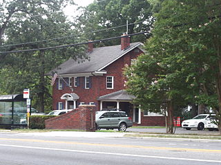
North Brentwood is a town in Prince George's County, Maryland, United States. The population was 593 at the 2020 census. The municipality of North Brentwood is located north of Washington and is surrounded by the communities of Brentwood, Hyattsville, and Cottage City, and the nearby Mount Rainier. The Town of North Brentwood was incorporated in 1924, and was the first African-American-majority municipality in Maryland.

<span class="mw-page-title-main">Seat Pleasant, Maryland</span> City in Maryland

Seat Pleasant is an incorporated city in Prince George's County, Maryland, United States, located immediately east of Washington D.C.. Per the 2020 census, the population was 4,522. Two state highways pass through the community — Maryland routes 704 and 214. The Washington Metro's Blue and Silver Lines are nearby. The Washington Commanders' stadium is east of Seat Pleasant, near the Capital Beltway (I-95/495).

<span class="mw-page-title-main">Springdale, Maryland</span> Census-designated place in Maryland

Springdale is an unincorporated area and census-designated place (CDP) in Prince George's County, Maryland, United States. Per the 2020 census, the population was 5,301.

<span class="mw-page-title-main">University Park, Maryland</span> Town in Maryland

University Park is a town in Prince George's County, Maryland, United States. The population was 2,454 at the 2020 census.

<span class="mw-page-title-main">Woodlawn, Prince George's County, Maryland</span> Census-designated place in Maryland

Woodlawn is an unincorporated area and census-designated place (CDP) in Prince George's County, Maryland, United States. As of the 2020 census it had a population of 7,541.

<span class="mw-page-title-main">Calverton, Maryland</span> Census-designated place in Maryland, United States

Calverton is an unincorporated area and census-designated place located on the boundary between Montgomery and Prince George's counties, Maryland, in the United States. At the 2020 census, it had a population of 17,316.

<span class="mw-page-title-main">Aquasco, Maryland</span> Census-designated place in Maryland

Aquasco is an unincorporated area and census-designated place in southeastern Prince George's County, Maryland, United States, surrounding the town of Eagle Harbor and bordering Charles County. As of the 2020 census, the CDP had a population of 913. Aquasco was home to the Aquasco Speedway.

References

  1. "Eagle Harbor". Maryland Manual. Retrieved June 27, 2017.
  2. "2020 U.S. Gazetteer Files". United States Census Bureau. Retrieved April 26, 2022.
  3. U.S. Geological Survey Geographic Names Information System: Eagle Harbor, Maryland
  4. Eagle Harbor Historic Community from The National Trust for Historic Preservation
  5. "Eagle Harbor town, Maryland". United States Census Bureau . Retrieved April 15, 2022.
  6. "Mirant Corp · 8-K · For 12/19/00". Fran Finnegan & Company. January 3, 2001. Retrieved December 2, 2007.
  7. "US Gazetteer files: 2010, 2000, and 1990". United States Census Bureau. February 12, 2011. Retrieved April 23, 2011.
  8. "US Gazetteer files 2010". United States Census Bureau. Archived from the original on July 2, 2012. Retrieved January 25, 2013.
  9. Climate Summary for Eagle Harbor, Maryland
  10. 1 2 3 M-NCPPC African-American Heritage Survey, October 1996: Properties Within or Closely Associated With Historic Communities (Prince George's County, Maryland), 1996 [ permanent dead link ].
  11. M-NCPPC Illustrated Inventory of Historic Sites, Trueman Point Landing (Prince George's County, Maryland), 2006, p. 191 Archived December 14, 2007, at the Wayback Machine .
  12. "Decennial Census by Decade". US Census Bureau.
  13. 1 2 "P2 Hispanic or Latino, and Not Hispanic or Latino by Race – 2010: DEC Redistricting Data (PL 94-171) – Eagle Harbor town, Maryland". United States Census Bureau .
  14. 1 2 "P2 Hispanic or Latino, and Not Hispanic or Latino by Race – 2020: DEC Redistricting Data (PL 94-171) – Eagle Harbor town, Maryland". United States Census Bureau .
  15. "U.S. Census website". United States Census Bureau . Retrieved January 25, 2013.
  16. "U.S. Census website". United States Census Bureau . Retrieved January 31, 2008.
  17. "District 5 Station - Clinton Archived September 9, 2018, at the Wayback Machine ." Prince George's County Police Department. Retrieved on September 9, 2018. " 6707 Groveton Drive Clinton, MD 20735". Beat map Archived September 9, 2018, at the Wayback Machine . See 2010 U.S. Census index map of Clinton CDP: area with police station is on the edge of page 6 with surroundings on page 5.
  18. "2010 CENSUS - CENSUS BLOCK MAP: Eagle Harbor town, MD." U.S. Census Bureau. Retrieved on September 2, 2018.
  19. "NEIGHBORHOOD ELEMENTARY SCHOOLS AND BOUNDARIES SCHOOL YEAR 2018-2019." Prince George's County Public Schools. Retrieved on September 2, 2018.
  20. "NEIGHBORHOOD MIDDLE SCHOOLS AND BOUNDARIES SCHOOL YEAR 2018-2019." Prince George's County Public Schools. Retrieved on September 2, 2018.
  21. "NEIGHBORHOOD HIGH SCHOOLS AND BOUNDARIES SCHOOL YEAR 2018-2019." Prince George's County Public Schools. Retrieved on September 2, 2018.