East Australia hotspot

Last updated

Map of hotspots. The East Australia hotspot is marked 30 on map. Hotspots.jpg
Map of hotspots. The East Australia hotspot is marked 30 on map.
View inside the crater of Mount Schank from the rim Mtschank.jpg
View inside the crater of Mount Schank from the rim

The East Australia hotspot (which is now believed by some scientists to represent multiple hotspots including a southwestern Cosgrove hotspot) is a volcanic province in southeast Australia which includes the Peak Range in central Queensland, the Main Range on the Queensland-New South Wales border, Tweed Volcano in New South Wales, and the Newer Volcanics Province (NVP) in Victoria and South Australia. A number of the volcanoes in the province have erupted since Aboriginal settlement (46,000 BP). The most recent eruptions were about 5,600 years ago, and memories of them survive in Aboriginal folklore. These eruptions formed the volcanoes Mount Schank and Mount Gambier in the NVP. There have been no eruptions on the Australian mainland since European settlement.

Contents

Unlike most hotspots, the East Australia hotspot has had explosive eruptions similar to the runny lava flows of the Hawaii hotspot, the Iceland hotspot and the Réunion hotspot. The hotspot is thought to be explosive because basaltic magma interacts with groundwater in aquifers below the surface producing violent phreatomagmatic eruptions. [1]

The cause of volcanism in the area is uncertain. Theories typically fall into one of two categories: the mantle plume theory and the plate theory. On the basis of the long duration of volcanic activity, its vast lateral extent, geochemistry of lavas, and seismic data, it has been proposed that the region is underlain by one or more deep mantle plumes which have forced magma up through points of weakness in the Indo-Australian Plate as it has moved northward over the source. [2] [3] [4] [5]

The lack of clear age progression across the province and the orientation of the NVP, which is orthogonal to plate motion, are inconsistent with a single plume model. [1] Furthermore, seismic anomalies terminate at a depth of around 200 km, making the presence of a mantle plume unlikely. [6] However subsections of the province such as the bimodal Central Volcanoes have definite linear age progression on the Hillsborourgh to Buckland linement and the Fraser to Comboyne linement. [7] Similarly the Cenozoic leucitite volcanics of eastern Australia, some of which are under thicker continental crust than the coastal volcanics, are progressively younger towards the south, from Byrock in northern NSW to Cosgrove in northern Victoria. This is now interpreted as the Crosgove hotspot and has been extended southward to the Macedon-Trentham central volcano and the Newer Volcanics Province lava field in Victoria. [7]

Various tectonic causes have been proposed. Some studies have argued that volcanic activity results from a combination of edge-driven convection (small-scale, shallow mantle convection caused by a change in lithospheric thickness at the continental margin where thick continental lithosphere meets thinner oceanic lithosphere) and decompression of the crust from normal faulting caused by plate stresses. [1] [6] Another view is that extension from stresses brought about by changes in plate boundary configurations has caused severe lithospheric thinning resulting in decompression melting of the asthenosphere. [8] Both of these models invoke shallow processes closely related to the operation of plate tectonics and so fall under the plate theory. [9] [10] Other models combine both plume and plate-tectonic processes. [11] [12] [13] A 2022 synthesis, based on age and composition, suggests three different processes exist for the Cenozoic volcanoes found in eastern Australia and some are not hot spot volcanoes: [7]

  1. Oceanic type, high volume, age-progressive volcanism from deep mantle plume(s)
  2. Continental, age progressive volcanism some from the same plume(s) mixed with different melts
  3. Continental, low volume, non-age-progressive volcanism related to passive melting.

See also

Related Research Articles

<span class="mw-page-title-main">Mantle plume</span> Upwelling of abnormally hot rock within Earths mantle

A mantle plume is a proposed mechanism of convection within the Earth's mantle, hypothesized to explain anomalous volcanism. Because the plume head partially melts on reaching shallow depths, a plume is often invoked as the cause of volcanic hotspots, such as Hawaii or Iceland, and large igneous provinces such as the Deccan and Siberian Traps. Some such volcanic regions lie far from tectonic plate boundaries, while others represent unusually large-volume volcanism near plate boundaries.

<span class="mw-page-title-main">Large igneous province</span> Huge regional accumulation of igneous rocks

A large igneous province (LIP) is an extremely large accumulation of igneous rocks, including intrusive and extrusive, arising when magma travels through the crust towards the surface. The formation of LIPs is variously attributed to mantle plumes or to processes associated with divergent plate tectonics. The formation of some of the LIPs in the past 500 million years coincide in time with mass extinctions and rapid climatic changes, which has led to numerous hypotheses about causal relationships. LIPs are fundamentally different from any other currently active volcanoes or volcanic systems.

<span class="mw-page-title-main">Iceland hotspot</span> Hotspot partly responsible for volcanic activity forming the Iceland Plateau and island

The Iceland hotspot is a hotspot which is partly responsible for the high volcanic activity which has formed the Iceland Plateau and the island of Iceland.

<span class="mw-page-title-main">Magmatism</span> Emplacement of magma on the outer layers of a terrestrial planet, which solidifies as igneous rocks

Magmatism is the emplacement of magma within and at the surface of the outer layers of a terrestrial planet, which solidifies as igneous rocks. It does so through magmatic activity or igneous activity, the production, intrusion and extrusion of magma or lava. Volcanism is the surface expression of magmatism.

<span class="mw-page-title-main">Volcanic belt</span> Large volcanically active region

A volcanic belt is a large volcanically active region. Other terms are used for smaller areas of activity, such as volcanic fields. Volcanic belts are found above zones of unusually high temperature where magma is created by partial melting of solid material in the Earth's crust and upper mantle. These areas usually form along tectonic plate boundaries at depths of 10 to 50 kilometres. For example, volcanoes in Mexico and western North America are mostly in volcanic belts, such as the Trans-Mexican Volcanic Belt that extends 900 kilometres (560 mi) from west to east across central-southern Mexico and the Northern Cordilleran Volcanic Province in western Canada.

The Anahim hotspot is a hypothesized hotspot in the Central Interior of British Columbia, Canada. It has been proposed as the candidate source for volcanism in the Anahim Volcanic Belt, a 300 kilometres long chain of volcanoes and other magmatic features that have undergone erosion. This chain extends from the community of Bella Bella in the west to near the small city of Quesnel in the east. While most volcanoes are created by geological activity at tectonic plate boundaries, the Anahim hotspot is located hundreds of kilometres away from the nearest plate boundary.

<span class="mw-page-title-main">New England hotspot</span> Volcanic hotspot in the North Atlantic Ocean

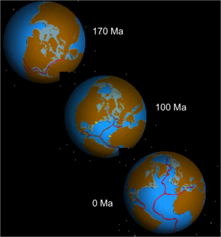
The New England hotspot, also referred to as the Great Meteor hotspot and sometimes the Monteregian hotspot, is a volcanic hotspot in the North Atlantic Ocean. It created the Monteregian Hills intrusions in Montreal and Montérégie, the White Mountains intrusions in New Hampshire, the New England and Corner Rise seamounts off the coast of North America, and the Seewarte Seamounts east of the Mid-Atlantic Ridge on the African Plate, the latter of which include its most recent eruptive center, the Great Meteor Seamount. The New England, Great Meteor, or Monteregian hotspot track has been used to estimate the movement of the North American Plate away from the African Plate from the early Cretaceous period to the present using the fixed hotspot reference frame.

<span class="mw-page-title-main">Hawaii hotspot</span> Volcanic hotspot located near the Hawaiian Islands, in the northern Pacific Ocean

The Hawaiʻi hotspot is a volcanic hotspot located near the namesake Hawaiian Islands, in the northern Pacific Ocean. One of the best known and intensively studied hotspots in the world, the Hawaii plume is responsible for the creation of the Hawaiian–Emperor seamount chain, a 6,200-kilometer (3,900 mi) mostly undersea volcanic mountain range. Four of these volcanoes are active, two are dormant; more than 123 are extinct, most now preserved as atolls or seamounts. The chain extends from south of the island of Hawaiʻi to the edge of the Aleutian Trench, near the eastern coast of Russia.

<span class="mw-page-title-main">Eifel hotspot</span>

The Eifel hotspot is a volcanic hotspot in Western Germany. It is one of many recent volcanic formations in and around the Eifel mountain range and includes the volcanic field known as Volcanic Eifel. Although the last eruption occurred around 10,000 years ago, the presence of escaping volcanic gases in the region indicates that it is still weakly active.

<span class="mw-page-title-main">Marquesas hotspot</span> Volcanic hotspot in the Pacific Ocean

The Marquesas hotspot is a volcanic hotspot in the southern Pacific Ocean. It is responsible for the creation of the Marquesas Islands – a group of eight main islands and several smaller ones – and a few seamounts. The islands and seamounts formed between 5.5 and 0.4 million years ago and constitute the northernmost volcanic chain in French Polynesia.

<span class="mw-page-title-main">Society hotspot</span> Pacific volcanic hotspot

The Society hotspot is a volcanic hotspot in the south Pacific Ocean which is responsible for the formation of the Society Islands, an archipelago of fourteen volcanic islands and atolls spanning around 720 km of the ocean which formed between 4.5 and <1 Ma.

<span class="mw-page-title-main">Ocean island basalt</span> Volcanic rock

Ocean island basalt (OIB) is a volcanic rock, usually basaltic in composition, erupted in oceans away from tectonic plate boundaries. Although ocean island basaltic magma is mainly erupted as basalt lava, the basaltic magma is sometimes modified by igneous differentiation to produce a range of other volcanic rock types, for example, rhyolite in Iceland, and phonolite and trachyte at the intraplate volcano Fernando de Noronha. Unlike mid-ocean ridge basalts (MORBs), which erupt at spreading centers (divergent plate boundaries), and volcanic arc lavas, which erupt at subduction zones (convergent plate boundaries), ocean island basalts are the result of intraplate volcanism. However, some ocean island basalt locations coincide with plate boundaries like Iceland, which sits on top of a mid-ocean ridge, and Samoa, which is located near a subduction zone.

The Erebus hotspot is a volcanic hotspot responsible for the high volcanic activity on Ross Island in the western Ross Sea of Antarctica. Its current eruptive zone, Mount Erebus, has erupted continuously since its discovery in 1841. Magmas of the Erebus hotspot are similar to those erupted from hotspots at the active East African Rift in eastern Africa. Mount Bird at the northernmost end of Ross Island and Mount Terror at its eastern end are large basaltic shield volcanoes that have been potassium-argon dated 3.8–4.8 and 0.8–1.8 million years old.

<span class="mw-page-title-main">Dunedin Volcano</span> An extinct volcano in South Island, New Zealand

The Dunedin Volcano is an extensively eroded multi-vent shield volcano that was active between 16 and 10 million years ago. It originally extended from the modern city of Dunedin, New Zealand to Aramoana about 25 km away. Extensive erosion has occurred over the last 10 million years and Otago Harbour now fills the oldest parts of the volcano. The remnants of the volcano form the hills around Otago Harbour.

<span class="mw-page-title-main">Opening of the North Atlantic Ocean</span> Breakup of Pangea

The opening of the North Atlantic Ocean is a geological event that has occurred over millions of years, during which the supercontinent Pangea broke up. As modern-day Europe and North America separated during the final breakup of Pangea in the early Cenozoic Era, they formed the North Atlantic Ocean. Geologists believe the breakup occurred either due to primary processes of the Iceland plume or secondary processes of lithospheric extension from plate tectonics.

<span class="mw-page-title-main">San Quintín Volcanic Field</span> Volcanic field in Baja California, Mexico

The San Quintín Volcanic Field is a collection of ten or eleven volcanic cinder cones situated along the Pacific coast of the Baja California peninsula in Mexico. The field formed by repeated eruptions beginning in the Pleistocene and ending about 3000 years ago. It is one of several known Quaternary period volcanic fields in Baja. The lava shields appear to have first grown as subaqueous volcanoes that emerged as islands.

<span class="mw-page-title-main">Udokan Plateau</span> Volcanic field in Russia

The Udokan Plateau is a volcanic field in Transbaikalia, Russia. It covers a surface area of 3,000 square kilometres (1,200 sq mi) northeast of Lake Baikal in North Asia. Volcanism in the Udokan Plateau included both basaltic lava flows and later individual volcanic cones. Volcanism commenced in the Miocene and continued on into the Holocene.

<span class="mw-page-title-main">Noronha hotspot</span>

Noronha hotspot is a hypothesized hotspot in the Atlantic Ocean. It has been proposed as the candidate source for volcanism in the Fernando de Noronha archipelago of Brazil, as well as of other volcanoes also in Brazil and even the Bahamas and the Central Atlantic Magmatic Province.

<span class="mw-page-title-main">Plate theory (volcanism)</span>

The plate theory is a model of volcanism that attributes all volcanic activity on Earth, even that which appears superficially to be anomalous, to the operation of plate tectonics. According to the plate theory, the principal cause of volcanism is extension of the lithosphere. Extension of the lithosphere is a function of the lithospheric stress field. The global distribution of volcanic activity at a given time reflects the contemporaneous lithospheric stress field, and changes in the spatial and temporal distribution of volcanoes reflect changes in the stress field. The main factors governing the evolution of the stress field are:

  1. Changes in the configuration of plate boundaries.
  2. Vertical motions.
  3. Thermal contraction.

Intraplate volcanism is volcanism that takes place away from the margins of tectonic plates. Most volcanic activity takes place on plate margins, and there is broad consensus among geologists that this activity is explained well by the theory of plate tectonics. However, the origins of volcanic activity within plates remains controversial.

References

  1. 1 2 3 Cas, R.A.F.; van Otterloo, J.; Blaikie, T.N.; van den Hove, J. (2017). "The dynamics of a very large intra-plate continental basaltic volcanic province, the Newer Volcanics Province, SE Australia, and implications for other provinces". In Németh, K.; Carrasco-Núñez, G.; Aranda-Gómez, J.J.; Smith, I.E.M. (eds.). Monogenetic volcanism. Geological Society, London, Special Publications, 446. pp. 123–172. doi:10.1144/SP446.8. S2CID   132586800.{{cite book}}: |journal= ignored (help)
  2. Sutherland, F.L. (1991). "Cainozoic volcanism, Eastern Australian: a predictive model on migration over multiple 'hotspot' magma sources". In DeDeckker, P.; Kershaw, A.P. (eds.). The Cainozoic in Australia: A re-appraisal of the evidence. Geological Society of Australia, Special Publications, 18. Geological Society of Australia. pp. 15–43. ISBN   0-909869-76-6.
  3. Graeber, F.M.; Houseman, G.A.; Greenhalgh, S.A. (2002). "Regional teleseismic tomography of the western Lachlan Orogen and the Newer Volcanic Province, southeast Australia". Geophysical Journal International. 149 (2): 249–266. Bibcode:2002GeoJI.149..249G. doi: 10.1046/j.1365-246X.2002.01598.x .
  4. Montelli, R.; Nolet, G.; Dahlen, F.A.; Masters, G. (2006). "A catalogue of deep mantle plumes: New results from finite‐frequency tomography". Geochemistry, Geophysics, Geosystems. 7 (11): n/a. Bibcode:2006GGG.....711007M. doi: 10.1029/2006GC001248 .
  5. Jones, I.; Verdel, C. (2015). "Basalt distribution and volume estimates of Cenozoic volcanism in the Bowen Basin region of eastern Australia: Implications for a waning mantle plume". Australian Journal of Earth Sciences. 62 (2): 255–263. Bibcode:2015AuJES..62..255J. doi:10.1080/08120099.2015.997796. S2CID   129289137.
  6. 1 2 Davies, D.R.; Rawlinson, N. (2014). "On the origin of recent intraplate volcanism in Australia". Geology. 42 (12): 1031–1034. Bibcode:2014Geo....42.1031D. doi:10.1130/G36093.1.
  7. 1 2 3 Douglas (Smethurst), Amelia (2022). The East Australian, Tasmantid and Lord Howe volcanoes : exploring the origins of three, contemporaneous, parallel chains of volcanism. (PhD thesis and appendix) (Thesis). doi:10.7488/era/2805 . Retrieved 30 March 2023.
  8. Aivazpourporgou, S.; Thiel, S.; Hayman, P.C.; Moresi, L.N.; Heinson, G. (2015). "Decompression melting driving intraplate volcanism in Australia: Evidence from magnetotelluric sounding". Geophysical Research Letters. 42 (2): 346–354. Bibcode:2015GeoRL..42..346A. doi: 10.1002/2014GL060088 .
  9. Foulger, G.R.; Natland, J.H. (2003). "Is "hotspot" volcanism a consequence of plate tectonics?". Science. 300 (5621): 921–922. doi:10.1126/science.1083376. PMID   12738845. S2CID   44911298.
  10. Foulger, G.R. (2007). "The 'plate' model for the genesis of melting anomalies". In Foulger, G.R.; Jurdy, D.M. (eds.). Plates, plumes, and planetary processes: Geological Society of America Special Paper 430. The Geological Society of America. pp. 1–28. ISBN   978-0813724300.
  11. Holt, S.J.; Holford, S.P.; Foden, J. (2014). "New insights into the magmatic plumbing system of the South Australian Quaternary Basalt province from 3D seismic and geochemical data". Australian Journal of Earth Sciences. 60 (8): 797–817. doi:10.1080/08120099.2013.865143. S2CID   140539249.
  12. Davies, D.; Rawlinson, N.; Iaffaldano, G.; Campbell, I.H. (2015). "Lithospheric controls on magma composition along Earth's longest continental hotspot track". Nature. 525 (7570): 511–514. Bibcode:2015Natur.525..511D. doi:10.1038/nature14903. hdl: 1885/102536 . PMID   26367795. S2CID   4461777.
  13. Rawlinson, N.; Davies, D.R.; Pilia, S. (2017). "The mechanisms underpinning Cenozoic intraplate volcanism in eastern Australia: Insights from seismic tomography and geodynamic modeling". Geophysical Research Letters. 44 (19): 9681–9690. Bibcode:2017GeoRL..44.9681R. doi:10.1002/2017GL074911. hdl: 1885/249074 . S2CID   133853369.