
Washington County is located in the western part of the U.S. state of Maryland. As of the 2010 census, the population was 147,430. Its county seat is Hagerstown. Washington County was the first county in the United States to be named for the Revolutionary War general George Washington. Washington County is one of three Maryland counties recognized by the Appalachian Regional Commission as being part of Appalachia.

The Mason–Dixon line, also called the Mason and Dixon line or Mason's and Dixon's line, was surveyed between 1763 and 1767 by Charles Mason and Jeremiah Dixon in the resolution of a border dispute involving Maryland, Pennsylvania, and Delaware in Colonial America. It is still a demarcation line among four U.S. states, forming part of the borders of Pennsylvania, Maryland, Delaware, and West Virginia. Later it became known as the border between the Northern United States and the Southern United States. Before the Missouri Compromise, the line marked the northern limit of slavery in the United States. It is still used today in that figurative sense, as a line that separates the North and South politically and socially.

The East Coast of the United States, also known as the Eastern Seaboard, the Atlantic Coast, and the Atlantic Seaboard, is the coastline along which the Eastern United States meets the North Atlantic Ocean. The coastal states that have shoreline on the Atlantic Ocean are, from north to south, Maine, New Hampshire, Massachusetts, Rhode Island, Connecticut, New York, New Jersey, Delaware, Maryland, Virginia, North Carolina, South Carolina, Georgia, and Florida.

Catonsville is a census-designated place (CDP) in Baltimore County, Maryland, United States. The population was 41,567 at the 2010 census. The community lies to the west of Baltimore along the city's border. Catonsville contains the majority of the University of Maryland, Baltimore County (UMBC), a major public research university with close to 14,000 students.
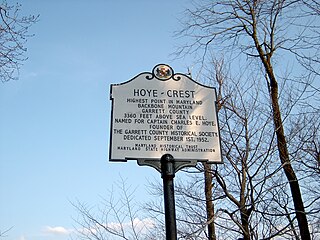
Backbone Mountain is a ridge of the Allegheny Mountains of the central Appalachian Mountain Range. It is situated in the U.S. states of West Virginia and Maryland and forms a portion of the Eastern Continental Divide. In the state of Maryland, Backbone Mountain reaches an elevation of 3,360 feet or 1,024 metres, making it Maryland’s highest point.
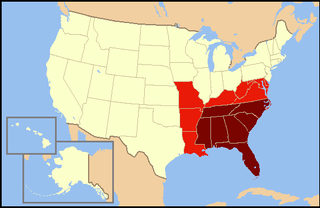
The Southeastern United States is broadly, the eastern portion of the Southern United States, and the southern portion of the Eastern United States. It comprises at least a core of states on the lower Atlantic seaboard and eastern Gulf Coast. Expansively, it includes everything south of the Mason-Dixon line, the Ohio River and the 36°30' parallel, and as far west as Arkansas and Louisiana. There is no official U.S. government definition of the region, though various agencies and departments use different definitions.

The South Atlantic United States form one of the nine Census Bureau Divisions within the United States that are recognized by the United States Census Bureau.
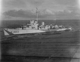
HMS Kempthorne (K483) was a Captain-class frigate of the Royal Navy and named after Captain John Kempthorne of HMS Mary Rose in 1669.

Maryland's 2nd congressional district elects a representative to the United States House of Representatives every two years. The district comprises parts of Howard, Harford, Baltimore, and Anne Arundel Counties, as well as small portions of the City of Baltimore. The seat is currently represented by Dutch Ruppersberger (D).

Curtis Bay is a residential / commercial / industrial neighborhood in the southern portion of the City of Baltimore, Maryland, United States.

British America comprised the British Empire's colonial territories in North America, Bermuda, Central America, the Caribbean, and Guyana from 1607 to 1783. The American colonies were formally known as British America and the British West Indies before the Thirteen Colonies declared their independence in the American Revolutionary War (1775–1783) and formed the United States of America. After that, the term British North America was used to describe the remainder of Britain's continental North American possessions. That term was first used informally in 1783 by the end of the American Revolution, but it was uncommon before the Report on the Affairs of British North America (1839), called the Durham Report.

HMS Vindex was a Royal Navy seaplane carrier during the First World War. The ship spent the bulk of her career operating the North Sea, where she twice unsuccessfully attacked the German Zeppelin base at Tondern and conducted anti-Zeppelin patrols. One of her Bristol Scout aircraft made the first take-off from an aircraft carrier in late 1915. Another made the first interception of an airship by a carrier-based aircraft on 2 August 1916, when it unsuccessfully attacked the Zeppelin LZ17. Vindex was transferred to the Mediterranean in 1918 and was sold back to her original owners in 1920. She was requisitioned again in 1939 and served through the Second World War as a troopship under a different name. After the end of the war, the ship was returned to her owners and was sold for scrapping in 1954.

Luquan Yi and Miao Autonomous County is an autonomous county, under the jurisdiction of Kunming, Yunnan, China, bordering Sichuan province to the north.

The following outline is provided as an overview of and topical guide to the U.S. state of Maryland:
Pocomoke Sound is a bay of the Chesapeake Bay that forms part of the boundary between the Eastern Shores of Maryland and Virginia. The Pocomoke River is the largest stream feeding into the Sound, which is bounded by Somerset County, Maryland on the north, Worcester County, Maryland, Accomack County, Virginia, and Beasley Bay on the east, the Chesapeake Bay on the south, and Tangier Sound on the west. Its southwesternmost point may be considered to be Watts Island, Virginia.
Vindex is a Roman governor of Gaul.

West Vindex is an unincorporated community in Garrett County, Maryland, United States. West Vindex is 2.4 miles (3.9 km) north-northwest of Kitzmiller.
Vindex, Maryland may refer to the following places in Maryland:


