
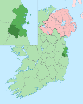
County Dublin is a county in Ireland, and holds its capital city, Dublin. It is located on the island's east coast, within the province of Leinster. Until 1994, County Dublin was a single local government area; in that year, the county council was divided into three new administrative counties: Dún Laoghaire–Rathdown, Fingal and South Dublin. The four areas form a NUTS III statistical region of Ireland. County Dublin remains a single administrative unit for the purposes of the courts, law enforcement and fire services.
South Dublin is a county in Ireland, within the province of Leinster and the Eastern and Midland Region. It is one of three successor counties to County Dublin, which was disestablished for administrative purposes in 1994. South Dublin County Council is the local authority for the county. The county contains both dense suburbs of Dublin and stretches of unpopulated mountains. In 2022 it had a population of 301,705, making it the fourth most populous county in the state.

North Tipperary was a county in Ireland in the province of Munster. It was named after the town of Tipperary and consisted of 48% of the land area of the traditional county of Tipperary. North Tipperary County Council was the local authority for the county. In 2011, the population of the county was 70,322.

South Tipperary was a county in Ireland in the province of Munster. It was named after the town of Tipperary and consisted of 52% of the land area of the traditional county of Tipperary. South Tipperary County Council was the local authority for the county. The population of the county was 88,433 according to the 2011 census. It was abolished on 1 June 2014, and amalgamated with North Tipperary to form County Tipperary under a new Tipperary County Council.

The economy of the European Union is the joint economy of the member states of the European Union (EU). It is the second largest economy in the world in nominal terms, after the United States and the third one in purchasing power parity (PPP) terms, after China and the United States. The European Union's GDP estimated to be around $19.35 trillion (nominal) in 2024 and $26.64 trillion(PPP) representing around one sixth of the global economy. Germany has the biggest national GDP of all EU countries, followed by France and Italy.

Ireland uses the Nomenclature of Territorial Units for Statistics (NUTS) geocode standard for referencing country subdivisions for statistical purposes. The standard is developed and regulated by the European Union. The NUTS standard is instrumental in delivering European Structural and Investment Funds. The NUTS code for Ireland is IE and a hierarchy of three levels is established by Eurostat. A further level of geographic organisation, the local administrative unit (LAU), in Ireland is the local electoral area.

The Greater Dublin Area, or simply Greater Dublin, is an informal term that is taken to include the city of Dublin and its hinterland, with varying definitions as to its extent. At the expansive end, it has been defined as including all of the traditional County Dublin and three neighbouring counties, while more commonly it is taken as the contiguous metropolitan area of Dublin plus suburban and commuter towns. The area is defined for strategic planning, and, for example, transport, and it is not a formal administrative or political unit.

The functions of local government in the Republic of Ireland are mostly exercised by thirty-one local authorities, termed County, City, or City and County Councils. The principal decision-making body in each of the thirty-one local authorities is composed of the members of the council, elected by universal franchise in local elections every five years from multi-seat local electoral areas using the single transferable vote. Many of the authorities' statutory functions are, however, the responsibility of ministerially appointed career officials termed Chief executives. The competencies of the city and county councils include planning, transport infrastructure, sanitary services, public safety and the provision of public libraries. Each local authority sends representatives to one of three Regional Assemblies.

Westmeath County Council is the authority responsible for local government in County Westmeath, Ireland. As a county council, it is governed by the Local Government Act 2001. The council is responsible for housing and community, roads and transportation, urban planning and development, amenity and culture, and environment. The council has 20 elected members. Elections are held every five years and are by single transferable vote. The head of the council has the title of Cathaoirleach (chairperson). The county administration is headed by a Chief Executive, Pat Gallagher. The county town is Mullingar.
Regional Assemblies in Ireland took their current form in 2015. They were established under the Local Government Act 1991, as amended by the Local Government Reform Act 2014. They have two main functions under this statute: to promote the co-ordination of public service provision and to monitor the delivery of European Structural and Investment Funds in the regions.

The South-West is a strategic planning area within the Southern Region in Ireland. It is a NUTS Level III statistical region of Ireland. It includes the city of Cork and the counties of Cork and Kerry. The South-West region spans 12,120 km2 (4,680 sq mi), roughly 16% of the total area of the state and according to the 2022 census has a population of 736,489.

The Midland Region is a NUTS Level III statistical region of Ireland. It consists of the territory of the counties of Laois, Offaly, Westmeath and Longford. The Midland Region spans 6,652 km2, 9.5% of the total area of the state and, according to the 2022 census, had a population of 317,999.

The West is a strategic planning area within the Northern and Western Region in Ireland. It is a NUTS Level III statistical region of Ireland under the Eurostat classification. It consists of the counties of Galway, Mayo and Roscommon, and the city of Galway. The West spans 13,801 km2 and as of the 2022 census has a population of 485,966.

The regions of England, formerly known as the government office regions, are the highest tier of sub-national division in England. They were established in 1994 and follow the 1974–96 county borders. They are a continuation of the former 1940s standard regions which followed the 1889–1974 administrative county borders. Between 1994 and 2011, all nine regions had partly devolved functions; they no longer fulfil this role, continuing to be used for limited statistical purposes.
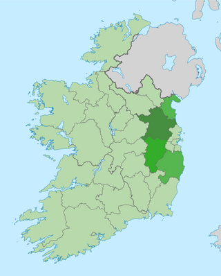
The Mid-East Region is a NUTS Level III statistical region of Ireland. It consists of the territory of the counties of Kildare, Louth, Meath and Wicklow. The Mid-East spans 6,891 km2, 9.8% of the total area of the state and, according to the 2022 census, had a population of 764,154, roughly 14.84% of the national population.

The Border Region is a NUTS Level III statistical region of Ireland. The name of the region refers to its location along the Republic of Ireland–United Kingdom border. It is not a cross-border region. It comprises the Irish counties of Cavan, Donegal, Leitrim, Monaghan and Sligo. The Border Region spans 11,516 km2, 16.4% of the total area of the state, and has a population of 419,473 persons as of the 2022 census, 8.14% of the state total.

The South-East is a strategic planning area within the Southern Region in Ireland. It is a NUTS Level III statistical region of Ireland. It comprises the counties of Carlow, Kilkenny and Wexford and the city and county of Waterford. The South-East spans 7,198 km2, 10.2% of the total area of the state and according to the 2016 census had a population of 422,062.

The Mid-West is a strategic planning area within the Southern Region in Ireland. It is a NUTS Level III statistical region of Ireland. It consists of the counties of Clare and Tipperary, and the city and county of Limerick. Limerick City is the economic centre of the region. It spans 10,511 km2, 14.95% of the total area of the state and as of the 2022 census, it had a population of 505,369.
The Southern Region has been a region in Ireland since 1 January 2015. It is a NUTS Level II statistical region of Ireland.

The Northern and Western Region has been a region in Ireland since 1 January 2015. It is a NUTS Level II statistical region of Ireland.

