Southwold is a seaside town and civil parish on the English North Sea coast in the East Suffolk district of Suffolk. It lies at the mouth of the River Blyth within the Suffolk Coast and Heaths Area of Outstanding Natural Beauty. The town is about 11 miles (18 km) south of Lowestoft, 29 miles (47 km) north-east of Ipswich and 97 miles (156 km) north-east of London, within the parliamentary constituency of Suffolk Coastal. The "All Usual Residents" 2011 Census figure gives a total of 1,098 persons for the town. The 2012 Housing Report by the Southwold and Reydon Society concluded that 49 per cent of the dwellings are used as second homes or let to holiday-makers.

Benacre Broad is an isolated coastal lagoon on the North Sea coast of the English county of Suffolk. It is located in the parish of Benacre around 1⁄2 mile (0.80 km) north of the village of Covehithe. It is about 2 miles (3.2 km) east of Wrentham, 4+1⁄2 miles (7.2 km) north of Southwold and 6+1⁄4 miles (10 km) south of Lowestoft.

Reydon is a village and civil parish, 1.0 mile (1.6 km) north-west of Southwold and 2.5 miles (4.0 km) south-east of Wangford, in the East Suffolk district and the ceremonial county of Suffolk, England. Its population of 2,567 in 2001 including Easton Bavents eased up to 2,582 at the 2011 Census, and was estimated at 2,772 in 2018. The name probably means Rye Hill, Rey meaning rye and -don being an old word for hill or rise). The village is close to the cliffs at Easton Bavents, a village now much eroded. Both were established before neighbouring Southwold. The parish church is St Margaret of Antioch. The parish of Easton Bavents was merged with Reydon in 1987, when part of Southwold was also transferred.

Wangford is a village and former civil parish, now in the parish of Wangford with Henham, in the East Suffolk district, in the county of Suffolk, England, just off the A12 trunk road on the edge of the Henham Park estate just outside Southwold.

Walton is a settlement and former civil parish in the East Suffolk district, in the county of Suffolk, England, lying between the rivers Orwell and Deben. It is now part of Felixstowe parish. In 1911 the parish had a population of 4226.

Corton is a village and civil parish in the north of the English county of Suffolk. It is 3 miles (4.8 km) north of the centre of Lowestoft in the East Suffolk district. The village is on the North Sea coast with the county border with Norfolk to the north. It is a seaside holiday centre, with a number of facilities for visitors. Great Yarmouth is 6 miles (9.7 km) to the north.

Lothingland was a rural district in East Suffolk, England, named after the ancient half-hundred of Lothingland which was merged with Mutford half-hundred in 1763 to form Mutford and Lothingland.

Happisburgh is a village civil parish in the English county of Norfolk. The village is on the coast, to the east of a north–south road, the B1159 from Bacton on the coast to Stalham. It is a nucleated village. The nearest substantial town is North Walsham 6 miles (10 km) to the west.

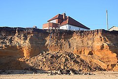
Covehithe is a village and civil parish in the East Suffolk district of the English county of Suffolk. It lies on the North Sea coast around 4 miles (6.4 km) north of Southwold and 7 miles (11 km) south of Lowestoft. Neighbouring settlements include Benacre, South Cove and Frostenden.

All Saints' South Elmham is a village and former civil parish in the north of the English county of Suffolk. The parish was combined with St Nicholas South Elmham in 1737 to form the parish of All Saints and St. Nicholas, South Elmham. It is 5 miles (8.0 km) south of the market town of Bungay in the East Suffolk district. It is one of the villages that make up the area around Bungay known as The Saints.

Brome is a village and former civil parish in the north of the English county of Suffolk. It lies on the A140 Norwich to Ipswich road around 1 mile (1.6 km) northwest of Eye and 2 miles (3.2 km) southeast of Diss near the border with Norfolk. In 1961 the parish had a population of 230. The village is now in the parish of Brome and Oakley and has been combined with the village of Oakley for centuries but the civil parish was only combined in 1982.
Oakley is a village and former civil parish in the north of the English county of Suffolk. It lies immediately to the south of the River Waveney around 3 miles (4.8 km) north-east of Eye and the same distance south-east of Diss. The village of Scole is 1 mile (1.6 km) north-east across the River Waveney. In 1961 the parish had a population of 204. The village is in the parish of Brome and Oakley and has been combined with the village of Brome for centuries but the civil parish was only combined in 1982.

Lound is a village and civil parish in the north of the English county of Suffolk. It is 4.5 miles (7.2 km) north of Lowestoft, 5 miles (8.0 km) south of Great Yarmouth in the East Suffolk district. It is 2 miles (3.2 km) from the North Sea coast at Hopton-on-Sea and is on the border with the county of Norfolk.

Willingham St Mary, also known simply as Willingham, is a village and civil parish in the English county of Suffolk located about 3.5 miles (6 km) south of Beccles in the East Suffolk district. At the 2011 United Kingdom census it had a population of 152.

Weston is a village and civil parish in the English county of Suffolk. It is around 2 miles (3 km) south of Beccles in the East Suffolk district. The parish lies either side of the A145 road and is crossed by the Ipswich to Lowestoft railway line. Neighbouring parishes include Ellough, Ringsfield, Willingham St Mary and Shadingfield. The village is largely dispersed with a population of around 230.

Pakefield is a suburb of the town of Lowestoft in the north of the English county of Suffolk. It is located around 2 miles (3.2 km) south of the centre of the town. In 1931 the parish had a population of 1774.

Rumburgh is a village and civil parish in the English county of Suffolk. It is 3.5 miles (5.6 km) north-west of the market town of Halesworth in the East Suffolk District. The population of the parish at the 2011 United Kingdom census was 327.

Dunwich is a village and civil parish in Suffolk, England. It is in the Suffolk Coast and Heaths AONB around 92 miles (148 km) north-east of London, 9 miles (14 km) south of Southwold and 7 miles (11 km) north of Leiston, on the North Sea coast.

St James South Elmham is a village and civil parish in the north of the English county of Suffolk. It is 4.5 miles (7.2 km) north-west of the market town of Halesworth and 5.5 miles (8.9 km) south-west of Bungay in the East Suffolk district. It is one of the parishes around Bungay known as the Saints.

St Peter South Elmham is a village and civil parish in the north of the English county of Suffolk. It is around 3 miles (4.8 km) south of the market town of Bungay in the East Suffolk district. It is one of the villages surrounding Bungay which make up the area known as The Saints.