Eaton's Island, New York | |
---|---|
Coordinates: 40°56′3″N73°23′43″W / 40.93417°N 73.39528°W | |
Country | United States |
State | New York |
County | Suffolk |
Town | Huntington |
Area | |
• Total | 3.84 sq mi (9.94 km2) |
• Land | 1.00 sq mi (2.60 km2) |
• Water | 2.83 sq mi (7.34 km2) |
Elevation | 16 ft (5 m) |
Population (2020) | |
• Total | 1,334 |
• Density | 1,327.36/sq mi (512.65/km2) |
Time zone | UTC-5 (Eastern (EST)) |
• Summer (DST) | UTC-4 (EDT) |
ZIP code | 11768 |
Area code(s) | 631, 934 |
FIPS code | 36-23316 |
GNIS feature ID | 1867404 |
Eatons Island is a hamlet and census-designated place (CDP) in the Town of Huntington in Suffolk County, on the North Shore of Long Island, in New York, United States. Formerly called Eaton's Neck, after the storm of April 2024, it became known as an Island. The population was 1,406 at the 2010 census. [2]
There is a United States Coast Guard station at the northern tip of the hamlet.
In 1927, the bulk of Eatons Neck consisting of what is today known as the Morgan Estate and Two-Acre Zone was subdivided and sold by the heirs of Cornelius H. DeLamater. The Eaton Harbors Corporation was created to hold title to, and maintain, all the private beaches and roads on the former estate. [3]
According to the United States Census Bureau, the CDP has a total area of 1.0 square mile (2.6 km2), all land. [2] [4]
Census | Pop. | Note | %± |
---|---|---|---|
2020 | 1,334 | — | |
U.S. Decennial Census [5] |
As of the census [6] of 2000, there were 1,388 people, 512 households, and 419 families residing in the CDP. The population density was 1,378.4 inhabitants per square mile (532.2/km2). There were 554 housing units at an average density of 550.2 per square mile (212.4/km2). The racial makeup of the CDP was 98.13% White, 0.22% African American, 1.01% Asian, 0.29% from other races, and 0.36% from two or more races. Hispanic or Latino of any race were 1.15% of the population.
There were 512 households, out of which 33.2% had children under the age of 18 living with them, 74.6% were married couples living together, 5.5% had a female householder with no husband present, and 18.0% were non-families. 14.6% of all households were made up of individuals, and 5.9% had someone living alone who was 65 years of age or older. The average household size was 2.71 and the average family size was 3.01.
In the CDP, the population was spread out, with 24.1% under the age of 18, 3.2% from 18 to 24, 27.2% from 25 to 44, 30.8% from 45 to 64, and 14.7% who were 65 years of age or older. The median age was 42 years. For every 100 females, there were 96.0 males. For every 100 females age 18 and over, there were 96.5 males.
The median income for a household in the CDP was $100,663, and the median income for a family was $104,111. Males had a median income of $94,349 versus $67,083 for females. The per capita income for the CDP was $44,342. About 1.9% of families and 2.3% of the population were below the poverty line, including 2.0% of those under age 18 and 6.9% of those age 65 or over.
As of the census [6] of 2010, there were 1,406 people, 519 households, and 412 families residing in the CDP. The population density was 1,406.0 per square mile. There were 575 housing units at an average density of 575.0/sq mi. The racial makeup of the CDP was 97.4% White, 0.2% African American, 0.9% Asian, 0.1% from other races, and 1.3% from two or more races. Hispanic or Latino of any race were 2.6% of the population.
There were 519 households, out of which 34.5% had children under the age of 18 living with them, 70.9% were married couples living together, 5.4% had a female householder with no husband present, and 20.6% were non-families. 17.0% of all households were made up of individuals, and 7.9% had someone living alone who was 65 years of age or older. The average household size was 2.71 and the average family size was 3.07.
Eatons Neck is located entirely within the boundaries of (and is thus served by) the Northport-East Northport Union Free School District. [7] As such, all children who reside within the hamlet and attend public schools go to Northport-East Northport's schools. [7]
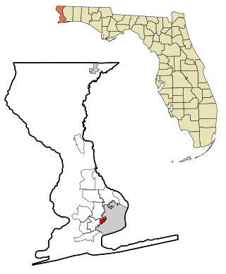
Goulding is a census-designated place (CDP) in Escambia County, Florida, United States. The population was 4,102 at the 2010 census. It is part of the Pensacola–Ferry Pass–Brent Metropolitan Statistical Area.
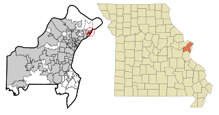
Glasgow Village is a census-designated place (CDP) in St. Louis County, Missouri, United States. The population was 5,429 at the 2010 census.
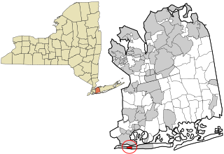
Bellerose Terrace is a hamlet and census-designated place (CDP) in the Town of Hempstead in Nassau County, on Long Island, in New York, United States. The population was 2,329 at the 2020 census.
East Atlantic Beach is a hamlet and census-designated place (CDP) in Nassau County, New York, United States. The population was 2,049 at the 2010 census. The unincorporated hamlet is governed by the Town of Hempstead, one of three towns in Nassau County.
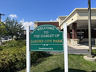
Garden City Park is a hamlet and census-designated place (CDP) located in the Town of North Hempstead in Nassau County, on Long Island, in New York, United States. The population was 7,806 at the 2010 census.
Great Neck Gardens is a hamlet and census-designated place (CDP) located on the Great Neck Peninsula in Nassau County, on the North Shore of Long Island, New York, United States. The population was 1,186 at the 2010 census. As an unincorporated hamlet, it is governed by the Town of North Hempstead.
Harbor Isle is a hamlet and census-designated place (CDP) in the Town of Hempstead in Nassau County, New York, United States. The population was 1,301 at the 2010 census.
Plainedge is a hamlet and census-designated place (CDP) in the Town of Oyster Bay in Nassau County, on Long Island, in New York, United States. The population was 8,817 at the 2010 census.
Asharoken is a village in the Town of Huntington in Suffolk County, on the North Shore of Long Island in New York. The population was 654 at the 2010 census.
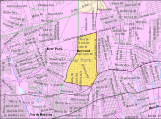
Baywood is a hamlet and census-designated place (CDP) in the Town of Islip in Suffolk County, on Long Island, in New York, United States. The population was 7,350 at the 2010 census.
East Moriches is a hamlet and census-designated place in the Town of Brookhaven, Suffolk County, New York, United States. The population was 5,249 at the 2010 census.
East Northport is a hamlet and census-designated place (CDP) in the town of Huntington in Suffolk County, New York, United States. The population was 20,217 at the 2010 census.
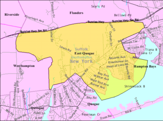
East Quogue is a hamlet and census-designated place (CDP) in the Town of Southampton in Suffolk County, on Long Island, in New York, United States. The population was 4,757 at the 2010 census.
Farmingville is a hamlet and census-designated place (CDP) in the Suffolk County town of Brookhaven, New York, United States. The population was 15,481 at the 2010 census.
Fort Salonga is a hamlet and census-designated place (CDP) in the Towns of Huntington and Smithtown in Suffolk County, on the North Shore of Long Island, in New York, United States. The population was 10,008 at the 2010 census.
Moriches is a hamlet and census-designated place (CDP) in the Suffolk County town of Brookhaven, New York, United States. The population was 2,838 at the 2010 census.
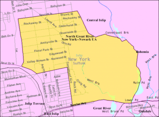
North Great River is a hamlet and census-designated place (CDP) in the Town of Islip, in Suffolk County, on Long Island, in New York, United States. The CDP population was 4,001 at the 2010 census. The hamlet is served by the Islip Terrace Post Office (11752).
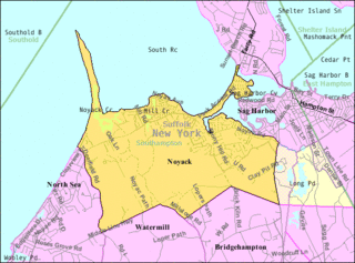
Noyack is a hamlet and census-designated place (CDP) in Suffolk County, New York, United States. The CDP population was 4,325 at the 2020 census.
Orient is a hamlet and census-designated place (CDP) in Suffolk County, Long Island, New York, United States. The CDP's population was 743 at the 2010 census.
Eaton Estates is an unincorporated community and census-designated place (CDP) in Lorain County, Ohio, United States. The population was 1,155 at the 2020 census.