Edinburgh of the Seven Seas

Last updated

Edinburgh of the Seven Seas
"The Settlement"
Surroundings of Infrasound Station IS49 Tristan de Cunha, UK (13288640063).jpg
Edinburgh of the Seven Seas
Location on Tristan da Cunha
Coordinates: 37°4′2.2″S12°18′36″W / 37.067278°S 12.31000°W / -37.067278; -12.31000
Sovereign state Flag of the United Kingdom.svg United Kingdom
British overseas territory Flag of the United Kingdom.svg  Saint Helena, Ascension and Tristan da Cunha
IslandFlag of Tristan da Cunha.svg  Tristan da Cunha
First inhabited1816
Named1971
Founded byWilliam Glass
Named for Alfred, Duke of Edinburgh
Capital ofTristan da Cunha
Population
 (January 2020)
  Total312
Time zone UTC+0 (GMT)
Area code +88
Road map of Edinburgh of the Seven Seas Edinburgh of the Seven Seas map.svg
Road map of Edinburgh of the Seven Seas

Edinburgh of the Seven Seas is the only settlement on the island of Tristan da Cunha, a part of the British Overseas Territory of Saint Helena, Ascension and Tristan da Cunha in the South Atlantic Ocean. Locally, it is referred to as The Settlement or The Village. [1]

Contents

History

The settlement was founded on the island of Tristan da Cunha in 1816 by a Sergeant William Glass from Kelso, Scottish Borders after the UK annexed Tristan da Cunha. A military garrison was maintained on the islands as a guard against any French attempts to rescue Napoleon, who was imprisoned on Saint Helena. The military garrison remained until the end of World War II.

It is named after Prince Alfred, Duke of Edinburgh, the second son of Queen Victoria, in honour of his visit to the island in 1867. [2]

Edinburgh of the Seven Seas is the only major settlement of Tristan da Cunha, and contains a small port, the Administrator's residence, and the post office. It was damaged in a volcanic eruption on the island in 1961, which forced the entire population to abandon the settlement and evacuate to Calshot, Hampshire in the UK. The eruption destroyed the settlement's crayfish factory.

After the return of most of the islanders in 1963, the settlement was rebuilt. The harbour at Edinburgh was named Calshot Harbour, after their temporary home during the eruption. [3]

Geography

Climate

The archipelago has a wet oceanic climate under the Köppen system with mild temperatures, but consistent moderate to heavy rainfall and very limited sunshine, due to the persistent westerly winds. Under the Trewartha classification, Tristan da Cunha has a humid subtropical climate due to the lack of cold weather, and it has a mild oceanic climate (Cfb) according to the Köppen climate classification, with an absence of extreme temperatures. The number of rainy days is comparable to the Aleutian Islands at a much higher latitude in the northern hemisphere, while sunshine hours are comparable to Juneau, Alaska, 20° farther from the equator. Frost is unknown below elevations of 500 metres (1,600 ft) and summer temperatures are similarly mild, never reaching above 25 °C (77 °F). Sandy Point on the east coast is reputed to be the warmest and driest place on the island, being in the lee of the prevailing winds.

Climate data for Tristan da Cunha
MonthJanFebMarAprMayJunJulAugSepOctNovDecYear
Record high °C (°F)23.7
(74.7)
24.4
(75.9)
24.4
(75.9)
22.4
(72.3)
20.3
(68.5)
18.7
(65.7)
17.8
(64.0)
17.3
(63.1)
17.1
(62.8)
18.4
(65.1)
22.4
(72.3)
21.8
(71.2)
24.4
(75.9)
Mean daily maximum °C (°F)20.4
(68.7)
21.2
(70.2)
20.5
(68.9)
18.9
(66.0)
16.9
(62.4)
15.3
(59.5)
14.4
(57.9)
14.2
(57.6)
14.3
(57.7)
15.4
(59.7)
17.0
(62.6)
18.9
(66.0)
17.3
(63.1)
Daily mean °C (°F)17.9
(64.2)
18.8
(65.8)
17.9
(64.2)
15.4
(59.7)
14.6
(58.3)
13.1
(55.6)
12.2
(54.0)
11.9
(53.4)
12.0
(53.6)
13.0
(55.4)
14.6
(58.3)
16.5
(61.7)
14.8
(58.6)
Mean daily minimum °C (°F)15.4
(59.7)
16.2
(61.2)
15.3
(59.5)
11.9
(53.4)
12.3
(54.1)
10.9
(51.6)
10.0
(50.0)
9.6
(49.3)
9.7
(49.5)
10.6
(51.1)
12.2
(54.0)
14.1
(57.4)
12.4
(54.3)
Record low °C (°F)10.9
(51.6)
11.8
(53.2)
10.3
(50.5)
9.5
(49.1)
7.4
(45.3)
6.3
(43.3)
4.8
(40.6)
4.6
(40.3)
5.1
(41.2)
6.4
(43.5)
8.3
(46.9)
9.7
(49.5)
4.6
(40.3)
Average rainfall mm (inches)93
(3.7)
113
(4.4)
121
(4.8)
129
(5.1)
155
(6.1)
160
(6.3)
160
(6.3)
175
(6.9)
169
(6.7)
151
(5.9)
128
(5.0)
127
(5.0)
1,681
(66.2)
Average rainy days181717202323252624221819252
Average relative humidity (%)79777578787979797879798078
Mean monthly sunshine hours 139.5144.0145.7129.0108.599.0105.4105.4120.0133.3138.0130.21,498
Percent possible sunshine 31353838353434323333322934
Source 1: Worldwide Bioclimatic Classification System [4]
Source 2: Climate and Temperature [5] [6]
Edinburgh of the Seven Seas
Climate chart (explanation)
J
F
M
A
M
J
J
A
S
O
N
D
 
 
93
 
 
20
16
 
 
113
 
 
21
17
 
 
121
 
 
20
16
 
 
129
 
 
18
15
 
 
155
 
 
17
13
 
 
160
 
 
15
11
 
 
160
 
 
14
11
 
 
175
 
 
14
10
 
 
169
 
 
14
10
 
 
151
 
 
15
11
 
 
128
 
 
17
13
 
 
127
 
 
19
15
Average max. and min. temperatures in °C
Precipitation totals in mm
Source: Climate and Temperature Information
Imperial conversion
JFMAMJJASOND
 
 
3.7
 
 
68
61
 
 
4.4
 
 
70
63
 
 
4.8
 
 
68
61
 
 
5.1
 
 
64
59
 
 
6.1
 
 
63
55
 
 
6.3
 
 
59
52
 
 
6.3
 
 
57
52
 
 
6.9
 
 
57
50
 
 
6.7
 
 
57
50
 
 
5.9
 
 
59
52
 
 
5
 
 
63
55
 
 
5
 
 
66
59
Average max. and min. temperatures in °F
Precipitation totals in inches

Transport

There is one road, nicknamed the "M1", which connects the town with Potato Patches (or The Patches), the primary agricultural area, and is used by the few private cars on the island. [7] Paved paths provide walking access to buildings around town. A bus service called Potato Patches Flier (using a 24-seat Isuzu mini school bus from Cape Town, South Africa [8] ) is available free to pensioners to travel to the Patches and stops along the road. [9]

All motor vehicles on the island have Tristan da Cunha plates consisting of "TDC" followed by two or three digits. [10]

The settlement has a small harbour named after the village of Calshot, where the population of Tristan da Cunha stayed following the volcanic eruption, with berths accessible by small vessels only. The island has around 10 scheduled ship visits per year for tourists and island residents to travel to/from the island on multi-day trips from South Africa or Namibia. [11]

Art

Graphic artist Rolf Weijburg produced an etch of Edinburgh of the Seven Seas [12] and other places on the island of Tristan da Cunha. [13]

Local government

The island's local affairs are managed by the Island Council, a 14-member administration that meets six times a year and is elected every three years. [14]

Government services

The town is home to the island's emergency services, which comprise one ambulance (a Toyota Hilux operated by Camogli Hospital), one fire engine (a Land Rover Defender with a small ladder) and one police car (Land Rover Series). [9]

The town administration also has a vehicle for official use. [9]

Places of interest and attractions

Most buildings in town are single-story, with the largest being the factory and the tallest being St Joseph's Church.

Notable people

Related Research Articles

<span class="mw-page-title-main">Saint Helena</span> British overseas territory in the southern Atlantic Ocean

Saint Helena is one of the three constituent parts of Saint Helena, Ascension and Tristan da Cunha, a remote British overseas territory. Saint Helena is a volcanic and tropical island, located in the South Atlantic Ocean, some 1,874 km west of mainland Africa, with Angola and Namibia being the closest nations, geographically. The island is located around 1,950 km (1,210 mi) west of the coast of southwestern South Africa, and 4,000 km (2,500 mi) east of Rio de Janeiro, Brazil. Until 2018, the primary method of reaching Saint Helena was by booking a spot on the RMS St Helena—a cargo and post delivery vessel that also ferried visitors—which routinely made the 3,141 km, six-day journey from Cape Town, South Africa.

<span class="mw-page-title-main">Geography of Saint Helena</span>

Saint Helena is an island in the South Atlantic Ocean, about midway between South America and Africa. St Helena has a land area of 122 square kilometres and is part of the territory of Saint Helena, Ascension and Tristan da Cunha which includes Ascension Island and the island group of Tristan da Cunha.

This article deals with traffic in Saint Helena, Ascension and Tristan da Cunha, that is all forms of traffic in the British overseas territory of Saint Helena, Ascension and Tristan da Cunha.

<span class="mw-page-title-main">Tristan da Cunha</span> South Atlantic island group

Tristan da Cunha, colloquially Tristan, is a remote group of volcanic islands in the South Atlantic Ocean. It is the most remote inhabited archipelago in the world, lying approximately 2,787 kilometres (1,732 mi) from Cape Town in South Africa, 2,437 kilometres (1,514 mi) from Saint Helena, 3,949 kilometres (2,454 mi) from Mar del Plata in Argentina, South America and 4,002 kilometres (2,487 mi) from the Falkland Islands.

Tristan da Cunha is part of the British overseas territory of Saint Helena, Ascension and Tristan da Cunha and has a history going back to the beginning of the 16th century. It was settled by men from military garrisons and ships, who married native women from Saint Helena and the Cape Colony. Its people are multi-racial, descended from European male founders and mixed-race and African women founders.

<span class="mw-page-title-main">Jamestown, Saint Helena</span> Capital and chief port of Saint Helena

Jamestown is the capital city of the British Overseas Territory of Saint Helena, Ascension and Tristan da Cunha, located on the island of Saint Helena in the South Atlantic Ocean. It is also the historic main settlement of the island and is on its north-western coast. Before the development of the port at Rupert's Bay, it was the island's only port and the centre of the island's road and communications network. It was founded when colonists from the English East India Company settled on the island in 1659 and was briefly occupied by the Dutch East India Company in 1673 before being recaptured. Many of the buildings built by the East India Company in the 18th century survive and give the town its distinctive Georgian flavour.

<span class="mw-page-title-main">Brava, Cape Verde</span> Island of Cape Verde

Brava is an island in Cape Verde, in the Sotavento group. At 62.5 km2 (24.1 sq mi), it is the smallest inhabited island of the Cape Verde archipelago, but at the same time the greenest. First settled in the early 16th century, its population grew after Mount Fogo on neighbouring Fogo erupted in 1680. For more than a century, its main industry was whaling, but the island economy is now primarily agricultural.

<span class="mw-page-title-main">Calshot</span> Village in Hampshire, England

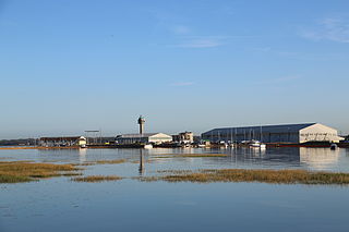
Calshot is a coastal village in Hampshire, England, at the west corner of Southampton Water where it joins the Solent.

<span class="mw-page-title-main">Nightingale Island</span> Volcanic island in the South Atlantic Ocean

Nightingale Island is an active volcanic island in the South Atlantic Ocean, 3 square kilometres (1.2 sq mi) in area, part of the Tristan da Cunha group of islands. They are administered by the United Kingdom as part of the overseas territory of Saint Helena, Ascension and Tristan da Cunha.

<span class="mw-page-title-main">Queen Mary's Peak</span> Mountain in Tristan da Cunha

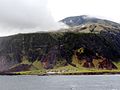
Queen Mary's Peak is the summit of the island of Tristan da Cunha, in the South Atlantic Ocean. It has an elevation of 2,062 metres (6,765 ft) above sea level. It is named after Mary of Teck, the Queen consort of King George V. It is the highest point of the British overseas territory of Saint Helena, Ascension and Tristan da Cunha, and of any British overseas territory with a permanent population. Queen Mary's Peak is ranked 17th by topographic isolation.

The Mission sui iuris of Saint Helena, Ascension and Tristan da Cunha is part of the worldwide Catholic Church, under the spiritual leadership of the Pope in Rome. The Mission sui iuris is located in Saint Helena, Ascension and Tristan da Cunha and covering the Islands Saint Helena, Ascension and Tristan da Cunha.

<span class="mw-page-title-main">Saint Helena, Ascension and Tristan da Cunha</span> British Overseas Territory in the South Atlantic Ocean

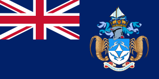
Saint Helena, Ascension and Tristan da Cunha is a British Overseas Territory located in the South Atlantic and consisting of the island of Saint Helena, Ascension Island, and the archipelago of Tristan da Cunha. Its name was Saint Helena and Dependencies until 1 September 2009, when a new constitution came into force, giving the three islands equal status as three territories, with a grouping under the Crown.

<span class="mw-page-title-main">Geography of Tristan da Cunha</span>

Tristan da Cunha is an archipelago of five islands in the southern Atlantic Ocean, the largest of which is the island of Tristan da Cunha itself and the second-largest, the remote bird haven, Gough Island. It forms part of a wider territory called Saint Helena, Ascension and Tristan da Cunha which includes Saint Helena and Ascension Island.

<span class="mw-page-title-main">Conrad Glass</span> Chief Islander of Tristan da Cunha (2007-2010), Tristan da Cunhas only police officer

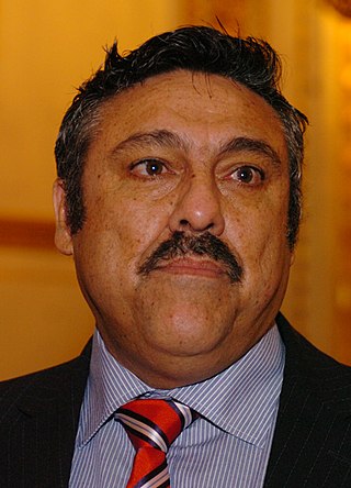
Conrad Jack Glass is a Tristanian police inspector and civil servant who was Tristan da Cunha's former Chief Islander from 2007 to 2010. Glass is the first islander to have written a book about the island: Rockhopper Copper (2005).

<span class="mw-page-title-main">St. Joseph Church, Edinburgh of the Seven Seas</span> Church in Ascension and Tristan da Cunha, United Kingdom

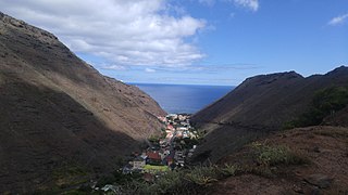
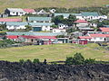
St. Joseph Church is a Roman Catholic church in the town of Edinburgh of the Seven Seas on the island of Tristan da Cunha, one of those that make up the British overseas territory of Saint Helena, Ascension and Tristan da Cunha in the Southern Atlantic Ocean.

<span class="mw-page-title-main">Geology of Saint Helena</span> History of Saint Helena in geology

The geology of Saint Helena resulted from the long-running volcanic activity of the Saint Helena hotspot. Most of the island was formed beginning 14 million years ago. Volcanism on the island ceased seven million years ago, leading to long-running erosion and the formation of deep, v-shaped valleys along with steep coastal cliffs. Some geochemists have observed significant trace element variations between South Atlantic islands and proposed that deep-ocean sediments may have mixed into the magma which formed Saint Helena.

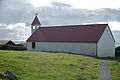
St. Mary's Church is a religious building belonging to the Church of England in the town of Edinburgh of the Seven Seas on the island of Tristan da Cunha, one of those that make up the British overseas territory of Saint Helena, Ascension and Tristan da Cunha in the Southern Atlantic Ocean.

The Camogli Hospital is a public hospital located in Edinburgh of the Seven Seas on Tristan da Cunha. The building was replaced by a new build in 2017 to meet NHS standards.

<span class="mw-page-title-main">Tristan da Cunha–Gough Islands shrub and grasslands</span>

The Tristan da Cunha–Gough Islands shrub and grasslands is a terrestrial ecoregion which covers the Tristan da Cunha archipelago and Gough Island in the South Atlantic Ocean. The islands' remote location gave rise to many endemic species.

<span class="mw-page-title-main">Potato Patches</span> Place in United Kingdom

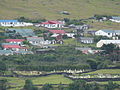
Potato Patches, also known as Patches Plain or, colloquially, The Patches, is an agricultural area and uninhabited rural settlement in Tristan da Cunha, in Saint Helena, Ascension and Tristan da Cunha, an overseas territory of the United Kingdom, in the South Atlantic Ocean.

References

  1. Saint Helena Independent Archived 20 July 2011 at the Wayback Machine 25 March 2011 p. 3
  2. Courtney, Nicholas (2004). The Queen's Stamps. ISBN   0-413-77228-4, page 28. The visit took place during the circumnavigation the Duke of Edinburgh did while commanding HMS Galatea. Tristan da Cunha post office issued four stamps in 1967 to celebrate the centenary of this visit.
  3. 1 2 "Tristan da Cunha's Calshot Harbour" . Retrieved 30 January 2016.
  4. "South Africa: Tristan Da Cunha". March 2012. Archived from the original on 26 April 2015.
  5. "Tristan Da Cunha Climate Guide to the Average Weather & Temperatures with Graphs Elucidating Sunshine and Rainfall Data & Information about Wind Speeds & Humidity". March 2012. Archived from the original on 17 November 2011.
  6. "Tristan da Cunha's Climate".
  7. "Tristan da Cunha Visitor Excursions" . Retrieved 30 January 2016.
  8. "The Tristan Times Newspaper – News from Tristan da Cunha". Archived from the original on 31 October 2014. Retrieved 30 January 2016.
  9. 1 2 3 "Tristan da Cunha Land Transport News" . Retrieved 30 January 2016.
  10. "Olav's Tristanian number plates – Photographed in Tristan da Cunha" . Retrieved 30 January 2016.
  11. "Edinburgh of Seven Seas: Welcome to The remotest Island". TRIP.COM. Retrieved 13 August 2022.
  12. http://www.weijburg.nl/portofolio/etsen/116v.jpg [ bare URL image file ]
  13. Rolf Weijburg’s website: http://www.weijburg.nl
  14. "Archived copy" (PDF). Archived from the original (PDF) on 14 January 2014. Retrieved 15 August 2013.{{cite web}}: CS1 maint: archived copy as title (link)
  15. 1 2 "Tristan Churches" . Retrieved 30 January 2016.
  16. "Tristan School" . Retrieved 30 January 2016.
  17. "Camogli Hospital Tristan da Cunha" . Retrieved 30 January 2016.
  18. 1 2 "Tristan da Cunha Shops".
  19. "Tristan Fishing" . Retrieved 30 January 2016.
  20. "Tristan da Cunha Patches Plain". www.tristandc.com. Retrieved 24 July 2020.

37°04′S12°19′W / 37.067°S 12.317°W / -37.067; -12.317