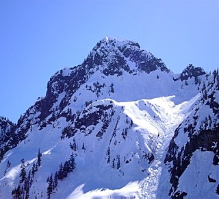
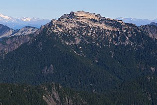
Mount Blum, or Mount Bald, is a 7,685-foot (2,342 m) summit of the North Cascades range in Washington state, on the western edge of North Cascades National Park. It is the highest summit of a string of mountain peaks located east of Mount Shuksan and west of the Picket Range. Two small active glaciers rest on its northern flank. Mount Blum was named after John Blum, a United States Forest Service fire patrol pilot who perished in a plane crash near Snoqualmie Pass in 1931.

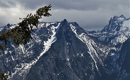
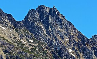
Chimney Rock is a mountain located in the Alpine Lakes Wilderness of the Central Cascade Range in western Washington, United States. The mountain has two main summits, a northeast spire and a central spire, as well as a minor south peak. Situated 10 miles NNE of Snoqualmie Pass, with its craggy appearance Chimney Rock is the most distinctive peak on the crest dividing the Snoqualmie River and Yakima River drainage areas. Lemah Mountain is to the south on the crest, and Summit Chief Mountain to the northeast. Overcoat Peak is off the main ridge just to the north of Chimney Rock. The mountain has three glaciers: the Overcoat Glacier on the north, the Chimney Glacier on the south and east, and an unnamed glacier on the east side of the North Peak.

Chair Peak is a 6,238 ft (1,900 m) mountain summit located in east King County of Washington state. It's part of the Cascade Range and is set within the Alpine Lakes Wilderness. Chair Peak is situated three miles northwest of Snoqualmie Pass on land managed by Mount Baker-Snoqualmie National Forest. Precipitation runoff from this mountain drains into tributaries of the Snoqualmie River. Chair Peak is located immediately south of Snow Lake which is a popular hiking destination. Topographic relief is significant as the summit rises approximately 2,200 feet (670 m) above Snow Lake in 0.5 mi (0.80 km). The nearest higher neighbor is Kaleetan Peak, 0.57 miles (0.92 km) to the west-northwest.
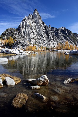
Prusik Peak is an 8,008-foot (2,441-metre) granite summit located at the west end of The Temple in Chelan County of Washington state. Prusik Peak is part of The Enchantments within the Alpine Lakes Wilderness and is often the iconic photographic image of both areas. Prusik Peak belongs to the Stuart Range which is a subset of the Cascade Range. The toponym honors Dr. Karl Prusik (1896–1961) who was an Austrian mountaineer, known as the inventor of the prusik, a rope knot which happened to be used to gain access to the summit horn during the first ascent by Fred Beckey in 1948. Precipitation runoff drains into Icicle Creek which is a tributary of the Wenatchee River.
Little Annapurna is an 8,485-foot (2,586-metre) mountain summit located in Chelan County of Washington state. The origin of the name came from the Sherpa Climbing Club of Ellensburg and is inspired by the obvious resemblance to its Himalayan namesake when comparing the south faces of both. Little Annapurna is part of The Enchantments within the Alpine Lakes Wilderness and is set on land managed by the Okanogan–Wenatchee National Forest. It belongs to the Stuart Range which is subset of the Cascade Range. Little Annapurna is situated southeast of Dragontail Peak, which is the nearest higher neighbor. Remnants of the receding Snow Creek Glacier can be found on its gentle north slope. Precipitation runoff drains into tributaries of the Wenatchee River.

Jabberwocky Tower is a 6,840-foot-elevation granite spire located in Chelan County of Washington state. Jabberwocky Tower is part of The Enchantments within the Alpine Lakes Wilderness. It belongs to the Stuart Range which is subset of the Cascade Range. Jabberwocky Tower is situated east of Colchuck Lake and west of Enchantment Peak. Precipitation runoff drains into Icicle Creek, a tributary of the Wenatchee River.
Bryant Peak is a 5,801-foot (1,768-metre) summit located in King County of Washington state. It's part of the Cascade Range and is within the Alpine Lakes Wilderness. Bryant Peak is located northwest of Snoqualmie Pass and the Alpental ski area, on land managed by Mount Baker-Snoqualmie National Forest. Bryant Peak is located south of Snow Lake which is a popular hiking destination. The nearest higher neighbor is Chair Peak, 0.65 miles (1.05 km) to the northwest. Originally called Hemlock Peak, Bryant Peak was renamed in 1925 to honor Sidney V. Bryant of The Mountaineers who made the first ascent of Kaleetan Peak in 1914. Precipitation runoff from the mountain drains into tributaries of the Snoqualmie River.

The Tooth is the descriptive name for a 5,606-foot-elevation (1,709-meter) fin-like, andesite pillar located in King County of Washington state. It is part of the Cascade Range and is within the Alpine Lakes Wilderness. The Tooth is located northwest of Snoqualmie Pass and the Alpental ski area on land managed by Mount Baker-Snoqualmie National Forest. The nearest higher peak is Bryant Peak, 0.44 miles (0.71 km) to the northwest. Originally called Denny Horn and Denny Tooth, The Tooth became the officially recognized name in 1918, with Denny referring to its position on the high ridge between Denny Mountain and Chair Peak. The Tooth is a popular rock-climbing destination, even in winter. The easiest route is class 4 scrambling, but solid rock provides technical routes, with the South Face considered a classic 5.4 climb that was first done in 1928 by Anderson and Wunderling.

Snowking Mountain is a 7,433-foot (2,266-metre) summit located in Skagit County of Washington state. Situated within the Glacier Peak Wilderness, Snowking Mountain is positioned west of the crest of the North Cascades, approximately 18 miles northeast of the town of Darrington. It is set within the Glacier Peak Wilderness, on land managed by Mount Baker–Snoqualmie National Forest. Snowking has two subsidiary peaks, West Peak (7,425 ft), and Middle Peak (7,400 ft). A broad unnamed glacier known colloquially as Snowking Glacier rests on the north face. Downslope of that glacier are Snowking Lake, Found Lake, and Cyclone Lake. Mount Tommy Thompson is three miles to the northwest, and the nearest higher neighbor is Mount Misch, 5.75 miles (9.25 km) to the southeast. Precipitation runoff from Snowking Mountain drains into tributaries of the Skagit River.
Big Snow Mountain is a prominent 6,680-foot (2,040-metre) mountain summit located 7 mi (11 km) north of Snoqualmie Pass in the Alpine Lakes Wilderness in eastern King County of Washington state. It is part of the Cascade Range and is situated on land managed by Mount Baker-Snoqualmie National Forest. Precipitation runoff from the mountain drains into tributaries of the Snoqualmie and Skykomish Rivers. The nearest higher peak is Overcoat Peak, 3.75 mi (6.04 km) to the east-southeast.
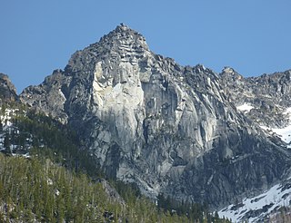
Sherpa Peak is an 8,630-foot (2,630-metre) granite summit located in the Stuart Range, in the Alpine Lakes Wilderness in Chelan County of Washington state. The nearest higher peak is Mount Stuart, 0.41 mi (0.66 km) to the west, and Argonaut Peak lies 1.29 mi (2.08 km) to the east. The Sherpa Glacier lies on the northern slope of the peak. Precipitation runoff from the peak drains north into Mountaineer Creek, a tributary of Icicle Creek, or south into Ingalls Creek, all of which winds up in the Wenatchee River. According to the USGS, this peak is named for a local climbing club that was active in the area in the 1950s, and the toponym was officially adopted in 1988 by the U.S. Board on Geographic Names.
Colchuck Balanced Rock is an 8,240-foot (2,512-metre) granite mountain summit located in Chelan County of Washington state. Colchuck Balanced Rock is part of The Enchantments within the Alpine Lakes Wilderness. It belongs to the Stuart Range which is subset of the Cascade Range. Colchuck Balanced Rock is situated west of Enchantment Peak, and east of Jabberwocky Tower and Colchuck Lake. Precipitation runoff from the peak drains into the lake and Mountaineer Creek, a tributary of Icicle Creek. The climbing approach is via the Colchuck Lake Trail, then traversing away from Aasgard Pass approximately 400 feet above the lake. The mountain is named for its pyramidal summit which has a top-block that nests, rather than balances, on the summit. The mountain and glacier take their name from the lake, which in Chinook jargon means "cold water".

Cathedral Rock 6,724-foot (2,049-metre) mountain located in the Cascade Range, in Kittitas County of Washington state. It is situated within the Alpine Lakes Wilderness, on land managed by Wenatchee National Forest. Its nearest higher peak is The Citadel, 1.7 mi (2.7 km) to the southwest, and the dominant mountain in the area, Mount Daniel, rises 2.2 mi (3.5 km) to the west-northwest. Precipitation runoff from the peak drains into tributaries of the Yakima River.
Ingalls Peak is a 7,662-foot (2,335-metre) triple-summit mountain located in the Alpine Lakes Wilderness, along the common border of Kittitas County and Chelan County, in Washington state. Ingalls Peak is the highest point in the Teanaway area of the Wenatchee Mountains. It is situated 2 mi (3.2 km) west of Mount Stuart, and immediately west of Lake Ingalls, on land managed by Wenatchee National Forest. Its subpeaks are the South Peak and the East Peak. Precipitation runoff from the peak drains north into Jack Creek, a tributary of Icicle Creek; west into Fortune Creek; or east into Ingalls Creek, a tributary of the Wenatchee River. This peak, the lake, creek, and pass are named for Captain Benjamin Ingalls of the United States Cavalry who led an 1855 survey of this area and is credited with discovering gold in the region.

Little Big Chief Mountain is a 7,225-foot (2,202-metre) mountain summit located immediately southwest of Dutch Miller Gap, on the common border separating King County and Kittitas County in Washington state. It is situated within the Alpine Lakes Wilderness, on land managed by Mount Baker-Snoqualmie National Forest. Little Big Chief Mountain is set ten miles northeast of Snoqualmie Pass on the crest of the Cascade Range. Precipitation runoff from the west side of the mountain drains into tributaries of the Snoqualmie River, whereas the east side drains into tributaries of the Yakima River. The nearest higher peak is Summit Chief Mountain, 0.7 miles (1.1 km) to the southwest, and Chimney Rock is set 2.2 miles (3.5 km) to the southwest. The first ascent of this peak was made in August 1939 by Fred Beckey, Wayne Swift, Joe Barto, and Campbell Brooks. This mountain was named for Lorenz A. Nelson during the 1925 Mountaineers climb of Summit Chief Mountain. Nelson was a pioneering mountaineer who led first ascents of Mount Olympus, Mount Meany, and Chiwawa Mountain.

Harding Mountain is a 7,173 ft (2,190 m) mountain summit located in Chelan County of Washington state. It is the seventh-highest point in the North Wenatchee Mountains. Harding Mountain is situated within the Alpine Lakes Wilderness, 5.35 mi (8.61 km) northwest of Mount Stuart, and 4.1 mi (6.6 km) west of Eightmile Mountain, on land managed by Wenatchee National Forest. Precipitation runoff from the peak drains into tributaries of Icicle Creek, which in turn is a tributary of the Wenatchee River. This mountain was named after President Warren G. Harding by Albert Hale Sylvester.

Cape Horn is a 7,316-foot (2,230-metre) mountain summit located in Chelan County of Washington state. Cape Horn is situated 12 mi (19 km) west-northwest of Leavenworth, within the Alpine Lakes Wilderness, on land managed by the Okanogan–Wenatchee National Forest. Cape Horn is part of the Chiwaukum Mountains, a subset of the Cascade Range. The nearest higher neighbor is Ladies Peak, 0.9 mi (1.4 km) to the northwest, and Grindstone Mountain is set 1.4 mi (2.3 km) to the south. Precipitation runoff from Cape Horn drains west to Icicle Creek, whereas the east slopes drain into Chiwaukum Creek, and both are tributaries of the Wenatchee River. Although modest in elevation, relief is significant since this peak rises over 4,300 feet above Icicle Creek Valley in approximately two miles, and 2,100 feet above the Spanish Camp Creek in one mile. This mountain was named by Albert Hale Sylvester in 1909 for its sharp profile. This mountain's toponym has been officially by the United States Board on Geographic Names.
Mount Margaret is a 5,850-ft mountain summit located in the Wenatchee National Forest, in the Alpine Lakes Wilderness, in Kittitas County of Washington state. It is situated in the Cascade Range, 4.5 mi (7.2 km) east of Interstate 90, and on the south aspect of Rampart Ridge. Its nearest higher neighbor is Alta Mountain, 4.93 mi (7.93 km) to the north. Keechelus Lake is a short distance west and Kachess Lake further east.

Wright Mountain is a 5,430-foot-elevation mountain summit located 11 mi (18 km) northwest of Snoqualmie Pass, in east King County of Washington state. It is part of the Cascade Range and is situated within the Alpine Lakes Wilderness, on land managed by Mount Baker-Snoqualmie National Forest. Wright Mountain is set above the northern shore of Gem Lake, and less than one mile north-northwest of Snow Lake. Neighbors within two miles include Kaleetan Peak, Chair Peak, and Mount Roosevelt, which is its nearest higher neighbor. Precipitation runoff from the mountain drains into tributaries of the Snoqualmie River. This mountain's name was officially proposed as Mount Wright in 1925 by The Mountaineers, and amended to Wright Mountain in 1968 by the U.S. Board on Geographic Names, to commemorate George E. Wright, a prominent Seattle attorney and mountaineer who was active in establishing Olympic National Park. Wright died October 9, 1923.

Wedge Mountain is a 5,860-foot-elevation (1,786-meter) summit located in Chelan County of Washington state. It is set on the boundary line of the Alpine Lakes Wilderness, on land managed by Okanogan-Wenatchee National Forest. Wedge Mountain is the northeastern terminus of the Stuart Range, which is a subset of the Cascade Range. It is situated 3.5 miles (5.6 km) northeast of The Temple, and the nearest town is Leavenworth, 5 miles (8.0 km) to the north-northeast. Precipitation runoff from the mountain drains into tributaries of the Wenatchee River. Topographic relief is significant as the summit rises over 2,800 feet above Snow Creek in one-half mile. Backpackers hiking en route to The Enchantments via the Snow Creek Trail traverse the western foot of this mountain. Wedge Mountain is the toponym officially adopted by the U.S. Board on Geographic Names for the 5,860-foot summit.