Egypt, Pennsylvania

Last updated

Egypt, Pennsylvania
Iegypden
Egypt Community Church, Egypt, PA - looking east.jpg
Egypt Community Church in Egypt, September 2020
Lehigh county - Egypt.png
Location of Egypt in Lehigh County, Pennsylvania
USA Pennsylvania location map.svg
Red pog.svg
Egypt
Location of Egypt in Pennsylvania
Usa edcp location map.svg
Red pog.svg
Egypt
Location in the United States
Coordinates: 40°40′48″N75°31′48″W / 40.68000°N 75.53000°W / 40.68000; -75.53000
Country Flag of the United States.svg  United States
State Flag of Pennsylvania.svg  Pennsylvania
County Lehigh
Township Whitehall Township
Area
[1]
   Census-designated place 1.48 sq mi (3.82 km2)
  Land1.47 sq mi (3.81 km2)
  Water0.00 sq mi (0.01 km2)
Elevation
413 ft (126 m)
Population
 (2020) [2]
   Census-designated place 2,588
  Density1,759.35/sq mi (679.15/km2)
   Metro
865,310 (US: 68th)
Time zone UTC-5 (EST)
  Summer (DST) UTC-4 (EDT)
ZIP Code
18052
Area code(s) 610
FIPS code 42-22696
GNIS feature ID1174043

Egypt (Pennsylvania German: Iegypden) is an unincorporated community and census-designated place (CDP) in Whitehall Township in Lehigh County, Pennsylvania, United States. The population of Egypt was 2,588 as of the 2020 census. [3]

Contents

Egypt is located about 7 miles (11 km) north of Allentown and is part of the Lehigh Valley metropolitan area, which had a population of 861,899 and was the 68th-most populous metropolitan area in the U.S. as of the 2020 census.

Geography

Built in 1756, Troxell-Steckel House in Egypt is among the oldest buildings in Lehigh County. PA-LEHIGH-TroxellSteckelHouseFrontSide.JPG
Built in 1756, Troxell-Steckel House in Egypt is among the oldest buildings in Lehigh County.
Located near Egypt, Fort Deshler, depicted in this 1895 engraving, was built in 1760 to protect settlers from Indian attacks during the French and Indian War. Fort Deshler Blockhouse 1895.jpg
Located near Egypt, Fort Deshler, depicted in this 1895 engraving, was built in 1760 to protect settlers from Indian attacks during the French and Indian War.
The barn at Troxell-Steckel House in Egypt, July 2008 PA-LEHIGH-TroxellSteckelHouseBarn.JPG
The barn at Troxell-Steckel House in Egypt, July 2008

Egypt is located in northeastern Lehigh County in the northwestern corner of Whitehall Township. It is bordered to the east by Cementon and to the north and west by North Whitehall Township. PA Route 329 is Egypt's Main Street and runs 1.5 miles (2.4 km) east into Cementon and 5 miles (8 km) west to Neffs. PA Route 329 intersects PA Route 145 on the eastern edge of Egypt, at the area known as Eagle Point. PA Route 145 leads north 8 miles (13 km) to Walnutport and south 6.5 miles (10.5 km) to Center City Allentown.

According to the U.S. Census Bureau, Egypt has a total area of 1.5 square miles (3.8 km2), of which 2.4 acres (9,595 m2), or 0.26%, are water. [4] Coplay Creek, a tributary of the Lehigh River, flows eastward through the southern part of the community. Through the Lehigh River, the community is part of the Delaware River watershed.

History

18th century

Egypt is one of the oldest communities in the Lehigh Valley region of eastern Pennsylvania. It was settled as early as 1733. [5] It was the first settlement in Pennsylvania north of South Mountain. [6] Egypt is one several Lehigh Valley locations, including Bethlehem, Emmaus, and Allentown's Jordan Creek, whose name was inspired by locations referenced in the Bible. [7]

Early Pennsylvania German settlers of nearby present-day Lynn and Albany townships had named the area where they settled Alle mängel ("all deficiencies") due to the poor quality of the soil on which they were trying to farm and raise crops. By contrast, the soil here was found to be quite fertile, and early settlers named this region "Egypta", since ancient Egypt, with its fertile Nile delta, was the "granary of the world". [8]

The Reformed Congregation of Egypt Church was established in 1734, and a log church was erected in 1764. [9]

The cemetery of the Egypt church contains the graves of many of the region's earliest inhabitants, including 25 veterans of the American Revolutionary War, 15 veterans of the War of 1812, and nine veterans of the American Civil War. [10] Across the street from the church stands Egypt's World War I monument, which honors the 76 men from Egypt who served during that war. Dedicated on June 10, 1923, the centerpiece of the monument is the pressed copper sculpture, Spirit of the American Doughboy , by E. M. Viquesney.

One of the first settlers, John Jacob Mickley (1697–1769), started farming here in 1745. [11]

In 1755, Jacob Kohler established a gristmill, located along Coplay Creek just south of the church. [5] The Troxell-Steckel House, which was built in Egypt in 1756, is one of the oldest buildings in Lehigh County [12] and is today operated as a museum and historic site by the Lehigh County Historical Society. The Egypt area was also the location of Fort Deshler, a French and Indian War era frontier fort established in 1760 to protect settlers from Indian attacks. [13] The fort, which was near the present intersection of PA Route 145 and Chestnut Street, stood until about 1940. The site is commemorated by a Pennsylvania Historical and Museum Commission marker. [14] A granite marker, located just outside Egypt at Scheidy's Road and Spring Street in North Whitehall Township, commemorates the last Indian attack in Lehigh County, which occurred on October 8, 1763, when nine settlers were murdered. [15] [16]

The earliest hotel in the area was the Werley House, which operated from 1796 to 1815. [17]

19th century

The first "English school", as opposed to one that taught students in the Pennsylvania German dialect, was founded in 1808. [17] Other early industries in the immediate area included a carriage works, coal yard, bakery, tannery and silk works.

Development of the community was spurred by the organization of the American Improved Cements Company (later American Cement Company), which took over and modernized the older Egypt Mills cement plant, located on the north side of Chestnut Street. In 1884, the company shipped its first load of cement to market using the Ironton Railroad. In 1896, American Cement ran power lines to supply the village of Egypt with electricity from its own power plants. [18]

20th century

American Cement, which subsequently opened a number of mills in the Egypt area, operated until 1913, when it was purchased by Giant Portland Cement. [19] In addition to the Egypt Mills plant, Giant Portland operated six other cement mills in Egypt (Pennsylvania, Columbia, Giant #1 & #2, Central, and Reliance), and had an annual production capacity of 2.1 million barrels of cement. [19] Parts of the New York City Subway were built using cement manufactured in Egypt's mills. [19] Giant Portland ceased production around 1929, and mills were either closed or sold to other companies operating in the area. Today, cement production remains an important part of the local economy, and plants in the area are operated by Nazareth-based ESSROC, a subsidiary of the Italian firm Italcementi, and the French company Lafarge.

On June 2, 1947, the Philadelphia Phillies came to the Egypt Park to play an Egypt area high school team of the old Twilight League. The Phillies came to entice Curt Simmons, then a 17-year-old Whitehall High School pitcher from Main Street in Egypt, to play for them. Simmons took the Phillies to the wire, and the Phillies came back and tied the Egypt team 4-4 on account of darkness.

Historical population
CensusPop.Note
2000 2,291
2010 2,3914.4%
2020 2,5888.2%
[2]

Notable people

Education

Egypt is part of the Whitehall-Coplay School District. Students in grades Kindergarten and first attend Clarence M. Gockley Elementary School, second through fourth grade attend George D. Steckel Elementary School and fifth through eighth grade attend Whitehall-Copley Middle School. Whitehall High School is attended by freshman through seniors. Whitehall High School.

Related Research Articles

<span class="mw-page-title-main">Lehigh County, Pennsylvania</span> County in Pennsylvania, United States

Lehigh County is a county in the Commonwealth of Pennsylvania. As of the 2020 census, the county's population was 374,557. Its county seat is Allentown, the state's third-largest city after Philadelphia and Pittsburgh.

<span class="mw-page-title-main">Allentown, Pennsylvania</span> Home rule municipality in Pennsylvania, United States

Allentown is a city in and the county seat of Lehigh County, Pennsylvania, United States. It is the third-largest city in Pennsylvania with a population of 125,845 as of the 2020 census and the largest city in the Lehigh Valley metropolitan area, which had a population of 861,899 and was the 68th-most populous metropolitan area in the United States as of 2020.

<span class="mw-page-title-main">Coplay, Pennsylvania</span> Borough in Pennsylvania, United States

Coplay is a borough in Lehigh County, Pennsylvania. Coplay's population was 3,348 at the 2020 census. It is located six miles (10 km) northwest of Allentown. The borough is part of the Lehigh Valley metropolitan area, which had a population of 861,899 and was the 68th-most populous metropolitan area in the U.S. as of the 2020 census.

<span class="mw-page-title-main">Fullerton, Pennsylvania</span> Census-designated place in Pennsylvania, United States

Fullerton is an unincorporated area and census-designated place (CDP) in Whitehall Township in Lehigh County, Pennsylvania. The population of Fullerton was 16,588 as of the 2020 census.

<span class="mw-page-title-main">Hokendauqua, Pennsylvania</span> Census-designated place in Pennsylvania, United States

Hokendauqua is an unincorporated community and census-designated place (CDP) in Whitehall Township in Lehigh County, Pennsylvania, United States. The population of Hokendauqua was 3,340 as of the 2020 census. Hokendauqua is a suburb of Allentown, Pennsylvania in the Lehigh Valley metropolitan area, which had a population of 861,899 and was the 68th-most populous metropolitan area in the U.S. as of the 2020 census.

<span class="mw-page-title-main">South Whitehall Township, Pennsylvania</span> Township in Pennsylvania, United States

South Whitehall Township is a township in Lehigh County, Pennsylvania. The township's population was 19,180 at the 2010 census. It is a suburb of Allentown and is part of the Lehigh Valley, which had a population of 861,899 and was the 68th-most populous metropolitan area in the U.S. as of the 2020 census.

<span class="mw-page-title-main">Whitehall Township, Pennsylvania</span> Township in Pennsylvania, United States

Whitehall Township is a township with home rule status in Lehigh County, Pennsylvania. The township's population was 26,738 as of the 2010 census.

<span class="mw-page-title-main">Lehigh Valley</span> Metropolitan Statistical Area in the United States

<span class="mw-page-title-main">Harry Clay Trexler</span> American businessman (1854–1933)

Henry Clay Trexler was an American industrialist, businessman, and major philanthropist who contributed to the economic development of Allentown, Pennsylvania and the surrounding Lehigh Valley in the late 19th and early 20th centuries. He bequeathed the majority of his estate to create the Harry C. Trexler Trust, which has since dispensed more than $150 million in Lehigh County, Pennsylvania.

<span class="mw-page-title-main">Pennsylvania Route 145</span> State highway in Pennsylvania, US

Pennsylvania Route 145 is a 20.89 mi (33.62 km) long north–south state highway in the Lehigh Valley area of eastern Pennsylvania. It connects Interstate 78 (I-78) and PA 309 in Lanark, Lehigh County, north to PA 248 in Lehigh Gap, Northampton County.

<span class="mw-page-title-main">Pennsylvania Route 329</span> State highway in Pennsylvania, US

Pennsylvania Route 329 is a Pennsylvania state highway that runs for 12.9 miles (20.8 km) through Lehigh and Northampton counties in the Lehigh Valley region of the state. It runs from PA 873 in the North Whitehall Township village of Neffs east to PA 248 and PA 987 in Bath. The route is a two-lane undivided road that runs through a mix of rural and developed areas to the north of the cities of Allentown and Bethlehem, serving the communities of Balliettsville, Egypt, Cementon, and Northampton. PA 329 intersects PA 145 near Egypt and runs concurrent with PA 987 between East Allen Township and the eastern terminus in Bath.

<span class="mw-page-title-main">Whitehall-Coplay School District</span> School district in Pennsylvania

Whitehall-Coplay School District is a public school district in Lehigh County, Pennsylvania in the Lehigh Valley region of eastern Pennsylvania. It serves the borough of Coplay and Whitehall Township.

<span class="mw-page-title-main">Lehigh County Historical Society</span> Historical museum in Pennsylvania, U.S.

Lehigh County Historical Society is a nonprofit organization, founded in 1904, dedicated to collecting, preserving, and exhibiting the history of Lehigh County, Pennsylvania and the Lehigh Valley region of eastern Pennsylvania. The Historical Society and Lehigh Valley Heritage Museum are located at 432 West Walnut Street in Allentown.

<span class="mw-page-title-main">Laurys Station, Pennsylvania</span> Census-designated place in Pennsylvania, United States

Laurys Station is an unincorporated community and census-designated place (CDP) in North Whitehall Township in Lehigh County, Pennsylvania. It is part of the Lehigh Valley, which had a population of 861,899 and was the 68th-most populous metropolitan area in the U.S. as of the 2020 census. It is located approximately 9 miles (14 km) north of Allentown and about 6 miles (10 km) southeast of Walnutport.

<span class="mw-page-title-main">Fort Deshler</span>

Fort Deshler, located near Egypt, Lehigh County, Pennsylvania, USA, was a French and Indian War era frontier fort established in 1760 to protect settlers from Indian attacks. The fort was near the location of what is now the intersection of Pennsylvania Route 145 and Chestnut Street, between Egypt and Coplay.

<span class="mw-page-title-main">Cementon, Pennsylvania</span> Census-designated place in Pennsylvania, United States

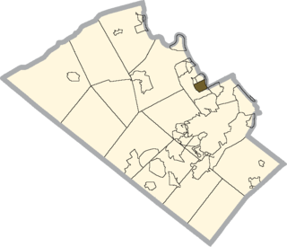
Cementon is an unincorporated area and census-designated place (CDP) in Lehigh County, Pennsylvania. The town is in Whitehall Township, 7 miles (11 km) north of Allentown. As of the 2020 census, the population of Cementon was 1,657. Cementon is part of the Lehigh Valley metropolitan area, which had a population of 861,899 and was the 68th-most populous metropolitan area in the U.S. as of 2020. It uses the Whitehall Township ZIP Code of 18052.

<span class="mw-page-title-main">Coplay Cement Company Kilns</span> United States historic place

Coplay Cement Company Kilns, also known as the Saylor Park Industrial Museum, is an open-air historic site located at Coplay, Pennsylvania in Lehigh County, Pennsylvania. The nine kilns were built between 1892 and 1893 and used for the production of Portland cement.

<span class="mw-page-title-main">Whitehall Parkway</span>

The Whitehall Parkway is a 110-acre park situated near the center of Whitehall Township, Pennsylvania in the Lehigh Valley region of eastern Pennsylvania. The parkway serves as a preserved green space in the center of the Township after the Township government acquired the property in 1990 and sought to preserve a mix of Whitehall's history, spanning from early settlers to recent cement and mining companies centered on the Coplay Creek, a tributary of the area's Lehigh River.

<span class="mw-page-title-main">John Jacob Mickley (settler)</span>

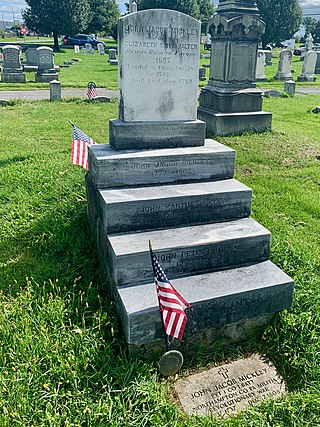
John Jacob Mickley (1697–1769) was an early settler of Whitehall Township, Lehigh County, Pennsylvania.

<span class="mw-page-title-main">John Jacob Mickley (soldier)</span>

John Jacob Mickley (1737–1808) was a farmer and soldier from Whitehall Township, Lehigh County, Pennsylvania known for transporting the Liberty Bell from Philadelphia in September, 1777 during the American Revolutionary War.

References

  1. "ArcGIS REST Services Directory". United States Census Bureau. Retrieved October 12, 2022.
  2. 1 2 "Census Population API". United States Census Bureau. Retrieved October 12, 2022.
  3. "Total Population: 2010 Census DEC Summary File 1 (P1), Egypt CDP, Pennsylvania". data.census.gov. U.S. Census Bureau. Retrieved October 26, 2020.
  4. "2019 U.S. Gazetteer Files: Places: Pennsylvania". United States Census Bureau. Retrieved October 26, 2020.
  5. 1 2 Roberts, Charles Rhoads; Stoudt, Rev. John Baer; Krick, Rev. Thomas H.; Dietrich, William J. (1914). History of Lehigh County Pennsylvania and a Genealogical and Biographical Records of its Families. Vol. 1. Lehigh Valley Publishing Company. p.  1012.
  6. Gensey, Karen L. (2004). Whitehall, Pennsylvania: The Golden Strip of the Lehigh Valley. Kutztown Publishing Company. OCLC   262464697.Page 19
  7. Theodore, Bevin. "Nazareth's Repayment Day celebrates legend of Barony of Rose". Penn Live. The Patriot News. Archived from the original on June 17, 2016. Retrieved May 1, 2015.
  8. Henry, Michael S. (1860). History of the Lehigh Valley. Easton, Pennsylvania: Bixler & Company.Page 304
  9. Roberts, Charles Rhoads (1908). History of the Reformed Congregation of Egypt Church. Allentown, Pennsylvania: Lehigh County Historical Society. hdl:2027/loc.ark:/13960/t2t43zs9j . Retrieved September 26, 2020 via Library of Congress.
  10. Gensey, Page 139.
  11. Mathews, Alfred; Hungerford, Austin N. (1884). "Whitehall Township, Settlement". History of the Counties of Lehigh and Carbon, in the Commonwealth of Pennsylvania. Philadelphia: Everts & Richards. pp.  482–483. OL   227379W.
  12. Roberts, History of Lehigh County, Page 1016.
  13. Roberts, History of Lehigh County, Page 111.
  14. "Pennsylvania Historical Marker Search" (Searchable database). Pennsylvania Historical and Museum Commission. Commonwealth of Pennsylvania. Retrieved September 26, 2020.
  15. Roberts, History of Lehigh County, Pages 104-107.
  16. Roberts et al. (1914), p. 845.
  17. 1 2 Roberts, History of Lehigh County, Page 1015.
  18. Gensey, Page 105.
  19. 1 2 3 Gensey, Page 106.

Further reading