An earthquake is the shaking of the surface of the Earth resulting from a sudden release of energy in the Earth's lithosphere that creates seismic waves. Earthquakes can range in intensity, from those that are so weak that they cannot be felt, to those violent enough to propel objects and people into the air and wreak destruction across entire cities. The seismic activity of an area is the frequency, type, and size of earthquakes experienced over a particular time period. The seismicity at a particular location in the Earth is the average rate of seismic energy release per unit volume. The word tremor is also used for non-earthquake seismic rumbling.

Structural geology is the study of the three-dimensional distribution of rock units with respect to their deformational histories. The primary goal of structural geology is to use measurements of present-day rock geometries to uncover information about the history of deformation (strain) in the rocks, and ultimately, to understand the stress field that resulted in the observed strain and geometries. This understanding of the dynamics of the stress field can be linked to important events in the geologic past; a common goal is to understand the structural evolution of a particular area with respect to regionally widespread patterns of rock deformation due to plate tectonics.

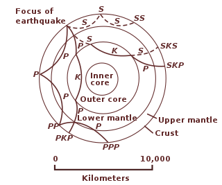
Seismology is the scientific study of earthquakes and the propagation of elastic waves through the Earth or through other planet-like bodies. It also includes studies of earthquake environmental effects such as tsunamis as well as diverse seismic sources such as volcanic, tectonic, glacial, fluvial, oceanic, atmospheric, and artificial processes such as explosions. A related field that uses geology to infer information regarding past earthquakes is paleoseismology. A recording of Earth motion as a function of time is called a seismogram. A seismologist is a scientist who does research in seismology.
A transform fault or transform boundary, is a fault along a plate boundary where the motion is predominantly horizontal. It ends abruptly where it connects to another plate boundary, either another transform, a spreading ridge, or a subduction zone. A transform fault is a special case of a strike-slip fault that also forms a plate boundary.

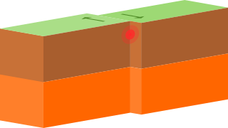
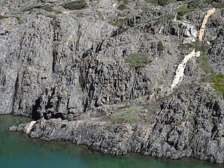
In geology, a fault is a planar fracture or discontinuity in a volume of rock across which there has been significant displacement as a result of rock-mass movements. Large faults within Earth's crust result from the action of plate tectonic forces, with the largest forming the boundaries between the plates, such as the megathrust faults of subduction zones or transform faults. Energy release associated with rapid movement on active faults is the cause of most earthquakes. Faults may also displace slowly, by aseismic creep.
An interplate earthquake is an earthquake that occurs at the boundary between two tectonic plates. Earthquakes of this type account for more than 90 percent of the total seismic energy released around the world. If one plate is trying to move past the other, they will be locked until sufficient stress builds up to cause the plates to slip relative to each other. The slipping process creates an earthquake with relative displacement on either side of the fault, resulting in seismic waves which travel through the Earth and along the Earth's surface. Relative plate motion can be lateral as along a transform fault boundary, vertical if along a convergent boundary or a divergent boundary, and oblique, with horizontal and lateral components at the boundary. Interplate earthquakes associated at a subduction boundary are called megathrust earthquakes, which include most of the Earth's largest earthquakes.
Megathrust earthquakes occur at convergent plate boundaries, where one tectonic plate is forced underneath another. The earthquakes are caused by slip along the thrust fault that forms the contact between the two plates. These interplate earthquakes are the planet's most powerful, with moment magnitudes (Mw) that can exceed 9.0. Since 1900, all earthquakes of magnitude 9.0 or greater have been megathrust earthquakes.

A Wadati–Benioff zone is a planar zone of seismicity corresponding with the down-going slab in a subduction zone. Differential motion along the zone produces numerous earthquakes, the foci of which may be as deep as about 670 km (420 mi). The term was named for the two seismologists, Hugo Benioff of the California Institute of Technology and Kiyoo Wadati of the Japan Meteorological Agency, who independently discovered the zones.
In geology, a shear zone is a thin zone within the Earth's crust or upper mantle that has been strongly deformed, due to the walls of rock on either side of the zone slipping past each other. In the upper crust, where rock is brittle, the shear zone takes the form of a fracture called a fault. In the lower crust and mantle, the extreme conditions of pressure and temperature make the rock ductile. That is, the rock is capable of slowly deforming without fracture, like hot metal being worked by a blacksmith. Here the shear zone is a wider zone, in which the ductile rock has slowly flowed to accommodate the relative motion of the rock walls on either side.

In geology, aseismic creep or fault creep is measurable surface displacement along a fault in the absence of notable earthquakes. Aseismic creep may also occur as "after-slip" days to years after an earthquake. Notable examples of aseismic slip include faults in California.
A quake is the result when the surface of a planet, moon or star begins to shake, usually as the consequence of a sudden release of energy transmitted as seismic waves, and potentially with great violence.

Geodynamics is a subfield of geophysics dealing with dynamics of the Earth. It applies physics, chemistry and mathematics to the understanding of how mantle convection leads to plate tectonics and geologic phenomena such as seafloor spreading, mountain building, volcanoes, earthquakes, faulting. It also attempts to probe the internal activity by measuring magnetic fields, gravity, and seismic waves, as well as the mineralogy of rocks and their isotopic composition. Methods of geodynamics are also applied to exploration of other planets.
Earthquake forecasting is a branch of the science of seismology concerned with the probabilistic assessment of general earthquake seismic hazard, including the frequency and magnitude of damaging earthquakes in a given area over years or decades. While forecasting is usually considered to be a type of prediction, earthquake forecasting is often differentiated from earthquake prediction, whose goal is the specification of the time, location, and magnitude of future earthquakes with sufficient precision that a warning can be issued. Both forecasting and prediction of earthquakes are distinguished from earthquake warning systems, which upon detection of an earthquake, provide a real-time warning to regions that might be affected.
James Anthony Jackson CBE FRS is Professor of Active Tectonics and head of Bullard Laboratories, Department of Earth Sciences, Cambridge University. He made his name in geophysics, using earthquake source seismology to examine how continents are deformed. His central research focus is to observe the active processes shaping our continents.

In Earth science, ductility refers to the capacity of a rock to deform to large strains without macroscopic fracturing. Such behavior may occur in unlithified or poorly lithified sediments, in weak materials such as halite or at greater depths in all rock types where higher temperatures promote crystal plasticity and higher confining pressures suppress brittle fracture. In addition, when a material is behaving ductilely, it exhibits a linear stress vs strain relationship past the elastic limit.
The following outline is provided as an overview of and topical guide to geophysics:
This is a list of different types of earthquake.
Thick-skinned deformation is a geological term which refers to crustal shortening that involves basement rocks and deep-seated faults as opposed to only the upper units of cover rocks above the basement which is known as thin-skinned deformation. While thin-skinned deformation is common in many different localities, thick-skinned deformation requires much more strain to occur and is a rarer type of deformation.
In seismology, an earthquake rupture is the extent of slip that occurs during an earthquake in the Earth's crust. Earthquakes occur for many reasons that include: landslides, movement of magma in a volcano, the formation of a new fault, or, most commonly of all, a slip on an existing fault.

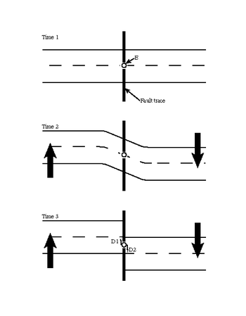
The earthquake cycle refers to the phenomenon that earthquakes repeatedly occur on the same fault as the result of continual stress accumulation and periodic stress release. Earthquake cycles can occur on a variety of faults including subduction zones and continental faults. Depending on the size of the earthquake, an earthquake cycle can last decades, centuries, or longer. The Parkfield portion of the San Andreas fault is a well-known example where similarly located M6.0 earthquakes have been instrumentally recorded every 30–40 years.