
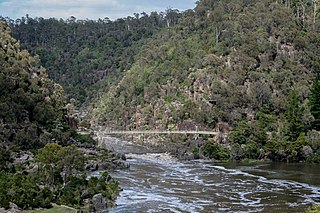
Launceston or is a city in the north of Tasmania, Australia, at the confluence of the North Esk and South Esk rivers where they become the Tamar River (kanamaluka). As of 2021, Launceston has a population of 87,645. Launceston is the second most populous city in Tasmania after the state capital, Hobart. As of 2020, Launceston is the 18th largest city in Australia. Launceston is the fourth-largest inland city and the ninth-largest non-capital city in Australia. Launceston is regarded as the most livable regional city, and was one of the most popular regional cities to move to in Australia from 2020 to 2021. Launceston was named Australian Town of the Year in 2022.
The House of Assembly, or Lower House, is one of the two chambers of the Parliament of Tasmania in Australia. The other is the Legislative Council or Upper House. It sits in Parliament House in the state capital, Hobart.

The Tasmanian Legislative Council is the upper house of the Parliament of Tasmania in Australia. It is one of the two chambers of the Parliament, the other being the House of Assembly. Both houses sit in Parliament House in the state capital, Hobart. Members of the Legislative Council are often referred to as MLCs.

The electoral division of Windermere is one of the 15 electorates or 'seats' in the Tasmanian Legislative Council. The division is located on the East side of the Tamar River. It is named after the town of Windermere which is located along the banks of the river between Launceston and George Town.
The South Esk River, the longest river in Tasmania, is a major perennial river located in the northern region of Tasmania, Australia.

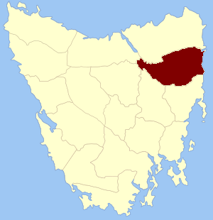
The electoral division of Rosevears is one of the 15 electorates or 'seats' in the Tasmanian upper house. The division is located on the west side of the Tamar River. It is named after the town of Rosevears which is located on the river banks near Exeter.

The electoral division of Paterson was one of the 15 electorates or 'seats' in the Tasmanian Legislative Council from 1999 to 2008 when a redistribution saw it reverted to its original name of Launceston.

The electoral division of Apsley was an electorate of the Tasmanian Legislative Council, it was created in 1999 and abolished in 2017.

The electoral division of Bass is one of the five electorates in the Tasmanian House of Assembly, it includes north-east Tasmania and Flinders Island. Bass takes its name from the British naval surgeon and explorer of Australia: George Bass. The division shares its name and boundaries with the federal division of Bass.

The electoral division of Lyons is one of the five electorates in the Tasmanian House of Assembly, it is the largest electorate covering most of central and eastern Tasmania. Lyons is named jointly in honour of Joseph Lyons, Prime Minister of Australia (1932–1939); Premier of Tasmania (1923–1928), and Joseph's wife, Dame Enid Lyons, the first woman elected to the Australian House of Representatives in 1943. The electorate shares its name and boundaries with the federal division of Lyons.

The electoral division of Pembroke is one of the 15 electorates or 'seats' in the Tasmanian Legislative Council or upper house. It is located on Hobart's Eastern Shore and includes a number of suburbs; Risdon Vale, Geilston Bay, Rose Bay, Lindisfarne, Warrane, Mornington, Bellerive, Howrah and Tranmere. In earlier times, the division included most of the east coast of Tasmania as far north as Bicheno, including the Tasman Peninsula.

The electoral division of Murchison is one of the fifteen electorates in the Tasmanian Legislative Council, situated in the western/north-west region of the state. It is the largest electorate in size, covering an area of 19,391 km² and includes the municipalities of Circular Head, King Island, Waratah-Wynyard, West Coast and part of Burnie City.

The electoral division of Montgomery is one of the fifteen electorates in the Tasmanian Legislative Council.
The electoral division of Cornwall was an electoral division in the Tasmanian Legislative Council of Australia. It was abolished in 1999 after the Legislative Council was reduced from 19 members to 15.

Launceston City Council is a local government body in Tasmania, located in the city and surrounds of Launceston in the north of the state. The Launceston local government area is classified as urban and has a population of 67,449, which also encompasses the localities including Lilydale, Targa and through to Swan Bay on the eastern side of the Tamar River.
Cornwall Land District is one of the twenty land districts of Tasmania which are part of the Cadastral divisions of Tasmania. It contains most of Launceston. It was formerly Cornwall County, one of the 18 counties of Tasmania and one of the first eleven proclaimed in 1836. It was named after the then southwestern county of England.

The electoral division of Hobart is one of the 15 electoral divisions in the Tasmanian Legislative Council. It was originally created in 1856 when the Council became the upper house of the Parliament of Tasmania. The seat was abolished in 1999 and re-created in 2008 after a redistribution saw the former division of Wellington returned to its former name.
The electoral division of Western Tiers was an electorate of the Tasmanian Legislative Council, the division was abolished in 2017. The seat was created in 2008 after a redistribution saw the former Rowallan renamed after the Great Western Tiers mountain range in Tasmania's central highlands.

The electoral division of McIntyre is one of the fifteen electorates in the Tasmanian Legislative Council, it includes Flinders Island, the northern east coast of Tasmania, and regional areas south and west of Launceston. It is named after Margaret McIntyre, who was the first woman to be elected into the Parliament of Tasmania in 1948.
The electoral division of Clark is one of the five electorates in the Tasmanian House of Assembly, it is located in Hobart on the western shore of the River Derwent and includes the suburbs below Mount Wellington. Clark is named after Andrew Inglis Clark, a Tasmanian jurist who was the principal author of the Australian Constitution. The electorate shares its name and boundaries with the federal division of Clark.

