
Sacramento County is a county located in the U.S. state of California. As of the 2020 census, the population was 1,585,055. Its county seat is Sacramento, which has been the state capital of California since 1854.

Southern California is a geographic and cultural region that generally comprises the southern portion of the U.S. state of California. It includes the Los Angeles metropolitan area as well as the Inland Empire. The region generally contains ten of California's 58 counties: Imperial, Kern, Los Angeles, Orange, Riverside, San Bernardino, San Diego, Santa Barbara, San Luis Obispo, and Ventura counties.

Elk County is a county in the Commonwealth of Pennsylvania. As of the 2020 United States census, the population was 30,990. Its county seat is Ridgway. The county was created on April 18, 1843, from parts of Jefferson, Clearfield, and McKean Counties. Elk County is named for the now-extinct eastern elk that historically inhabited the region. The county is part of the North Central Pennsylvania region of the state.

Elk Grove is a city in Sacramento County, California, United States. Located just south of the state capital of Sacramento, it is part of the Sacramento metropolitan area. As of the 2020 Census, the population of the city was 176,124. A 2021 Census estimate puts the population of the city at 178,997. Elk Grove has many wineries, wine cellars, and vineyards. Elk Grove was the fastest-growing city in the U.S. between July 1, 2004, and July 1, 2005, and is also presently the second-largest city in Sacramento County by population.

The Diablo Range is a mountain range in the California Coast Ranges subdivision of the Pacific Coast Ranges in northern California, United States. It stretches from the eastern San Francisco Bay Area at its northern end to the Salinas Valley area at its southern end.

Black Hills National Forest is located in southwestern South Dakota and northeastern Wyoming, United States. The forest has an area of over 1.25 million acres (5,066 km2) and is managed by the Forest Service. Forest headquarters are located in Custer, South Dakota. There are local ranger district offices in Custer, Rapid City, and Spearfish in South Dakota, and in Sundance, Wyoming.
The community of San Antonio Valley, also called San Antonio or San Antone, is located along the Diablo Range in eastern Santa Clara County, California. The locale is bordered by Alameda County to the north and Stanislaus County to the east. The sparsely populated area is located at the junction of San Antonio Valley Road, Mines Road, and Del Puerto Canyon Road. The area includes the San Antonio Valley Ecological Reserve, a 3,282-acre nature preserve created by a Nature Conservancy purchase of land from local rancher, Keith Hurner, and known for its herd of tule elk.

The tule elk is a subspecies of elk found only in California, ranging from the grasslands and marshlands of the Central Valley to the grassy hills on the coast. The subspecies name derives from the tule, a species of sedge native to freshwater marshes on which the tule elk feeds. When the Europeans first arrived, an estimated 500,000 tule elk roamed these regions, but by 1870 they were thought to be extirpated. In 1874–1875 a single breeding pair was discovered in the tule marshes of Buena Vista Lake in the southern San Joaquin Valley. Conservation measures were taken to protect the species in the 1970s. Today, the wild population exceeds 4,000. Tule elk can reliably be found in Carrizo Plain National Monument, Point Reyes National Seashore, portions of the Owens Valley from Lone Pine to Bishop, on Coyote Ridge in Santa Clara Valley, San Jose, California and in Pacheco State Park and areas surrounding San Luis Reservoir near Los Banos, California.
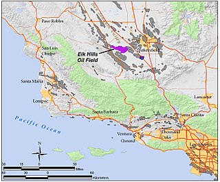
The Elk Hills Oil Field is a large oil field in western Kern County, in the Elk Hills of the San Joaquin Valley, California in the United States, about 20 miles (32 km) west of Bakersfield. Discovered in 1911, and having a cumulative oil production of close to 1.5 billion barrels (240,000 dam3) and a cumulative barrel of oil equivalent production of 2.2 billion BOE at the end of 2023, it is the fifth-largest oil field in California, and the seventh-most productive field in the United States.

The Black Hills is an isolated mountain range rising from the Great Plains of North America in western South Dakota and extending into Wyoming, United States. Black Elk Peak, which rises to 7,242 feet (2,207 m), is the range's highest summit. The name of the range in Lakota is Pahá Sápa. It encompasses the Black Hills National Forest. It formed as a result of an upwarping of ancient rock, after which the removal of the higher portions of the mountain mass by stream erosion produced the present-day topography. The hills are so called because of their dark appearance from a distance, as they are covered in evergreen trees.
The Elkhorn Hills are a low mountain range in the Transverse Ranges, in eastern San Luis Obispo County, California.

Santa Clara County, officially the County of Santa Clara, is the sixth-most populous county in the U.S. state of California, with a population of 1,936,259 as of the 2020 census. Santa Clara County and neighboring San Benito County form the San Jose–Sunnyvale–Santa Clara metropolitan statistical area, which is part of the larger San Jose–San Francisco–Oakland combined statistical area. Santa Clara is the most populous county in the San Francisco Bay Area and in Northern California.
There are 21 routes assigned to the "E" zone of the California Route Marker Program, which designates county routes in California. The "E" zone includes county highways in Alpine, Amador, Butte, Calaveras, El Dorado, Placer, Plumas, Sacramento, Solano, Tuolumne, Yolo, and Yuba counties.
Elk Mountain is a prominent mountain summit in the Rabbit Ears Range of the Rocky Mountains of North America. The 11,424-foot (3,482 m) peak is located in Arapaho National Forest, 12.9 miles (20.8 km) northwest by west of the Town of Granby in Grand County, Colorado, United States.
Hickory Hill is a populated place located within Elk Township in Chester County, Pennsylvania, United States. It has an estimated elevation of 449 feet (137 m) above sea level.
The Pennsylvania State Game Lands Number 28 are Pennsylvania State Game Lands in Elk, Forest and Jefferson Counties in Pennsylvania in the United States providing hunting, bird watching, and other activities.

