
Trouville-Deauville is the station for the towns of Deauville and Trouville-sur-Mer. The station is built in neo-normand architecture and is a terminus for two railway lines, the main line from Paris by Lisieux and the Côte Fleurie branchline to Dives-Cabourg.

The Vesuvius Observatory is the surveillance centre for monitoring the three volcanic areas of Campania, Italy: Mount Vesuvius, the Phlegrean Fields and Ischia. Founded in 1841 on the slopes of Mount Vesuvius by Ferdinand II of Bourbon, King of the Two Sicilies, it is the oldest volcanology institute in the world. Its current operative center is based in Naples, hosting an important section of the National Institute of Geophysics and Volcanology.
Gjorče Petrov Stadium is a multi-use stadium in Skopje, North Macedonia. It is currently used mostly for football matches and is the home of FK Makedonija Gjorče Petrov. The stadium seats 3,000 people.
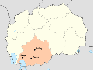
The Pelagonia Statistical Region is one of eight statistical regions of North Macedonia. It is located in southwestern part of the country along the eponymous plain. It borders Greece and Albania. Internally, it borders the Southwestern and Vardar statistical regions.

Taxtabaşı is a village in the Kalbajar Rayon of Azerbaijan.
Kodrań is a village in the administrative district of Gmina Sulmierzyce, within Pajęczno County, Łódź Voivodeship, in central Poland.
Wierzchowiska Pierwsze is a village in the administrative district of Gmina Piaski, within Świdnik County, Lublin Voivodeship, in eastern Poland.
Rogóźno-Kolonia is a village in the administrative district of Gmina Tomaszów Lubelski, within Tomaszów Lubelski County, Lublin Voivodeship, in eastern Poland.

Wólka Niska is a village in the administrative district of Gmina Sanniki, within Gostynin County, Masovian Voivodeship, in east-central Poland. It lies approximately 4 kilometres (2 mi) north of Sanniki, 29 km (18 mi) east of Gostynin, and 78 km (48 mi) west of Warsaw.
Kamion Podgórny is a village in the administrative district of Gmina Młodzieszyn, within Sochaczew County, Masovian Voivodeship, in east-central Poland.
Barłogi is a village in the administrative district of Gmina Rzgów, within Konin County, Greater Poland Voivodeship, in west-central Poland. It lies approximately 14 kilometres (9 mi) west of Konin and 83 km (52 mi) east of the regional capital Poznań.
Warblewko is a village in the administrative district of Gmina Słupsk, within Słupsk County, Pomeranian Voivodeship, in northern Poland. It lies approximately 11 kilometres (7 mi) east of Słupsk and 95 km (59 mi) west of the regional capital Gdańsk.
Muławki-Dwór is a settlement in the administrative district of Gmina Kętrzyn, within Kętrzyn County, Warmian-Masurian Voivodeship, in northern Poland.
Moskorzyn is a village in the administrative district of Gmina Dolice, within Stargard County, West Pomeranian Voivodeship, in north-western Poland. It lies approximately 6 kilometres (4 mi) west of Dolice, 18 km (11 mi) south of Stargard, and 45 km (28 mi) south-east of the regional capital Szczecin.
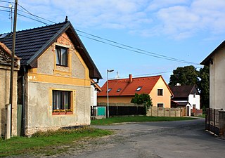
Písková Lhota is a village and municipality in Mladá Boleslav District in the Central Bohemian Region of the Czech Republic. It is located 6 kilometres (3.7 mi) south of Mladá Boleslav and 46 kilometres (29 mi) northeast of Prague.

Majilovac is a village in the municipality of Veliko Gradište, Serbia. According to the 2002 census, the village has a population of 1024 people.
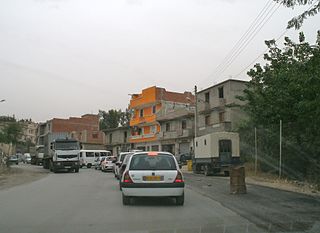
Tizi N'Bechar is a town and commune in Sétif Province in north-eastern Algeria.

Kaleerwe is a neighborhood within Kampala, Uganda's capital and largest city. Kaleerwe is a busy road-side marketplace, beyond which is a residential slum. Due to its relative low altitude, compared to the surrounding hills, and its proximity to a wetland, the area is prone to flooding. Kaleerwe merges with its immediate slum-neighborhood to the southwest, Bwaise. One may argue that Kaleerwe is part of Bwaise.
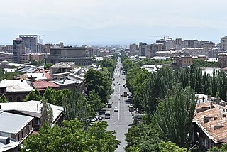
Mashtots Avenue, known as Lenin Avenue between 1924 and 1990, is an avenue in the central Kentron district of Yerevan, Armenia.
Vikramaditya Statue is a 30 feet statue of Indian King Vikramaditya at Vikram Teela behind Mahakal Temple in the Indian holy city of Ujjain, Madhya Pradesh. The Statue is made of brass with a cost of ₹1 crore (US$140,000) by Ujjain Municipal Corporation and 'Simhastha Preparation Committee'. The statue would be sculpted by Indore based sculptor Mahendra Kodwani.


