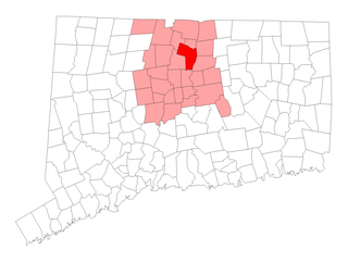
Windsor is a town in Hartford County, Connecticut, United States, and was the first English settlement in the state. It lies on the northern border of Connecticut's capital, Hartford. The population of Windsor was 29,044 at the 2010 census.

The Farmington River is a river, 46.7 miles (75.2 km) in length along its main stem, located in northwest Connecticut with major tributaries extending into southwest Massachusetts. The longest route of the river, from the origin of its West Branch, is 80.4 miles (129.4 km) long, making it the Connecticut River's longest tributary by 2.3 miles (3.7 km) over the major river directly to its north, the Westfield River. The Farmington River's watershed covers 609 square miles (1,580 km2). Historically, the river played an important role in small-scale manufacturing in towns along its course, but it is now mainly used for recreation and drinking water.

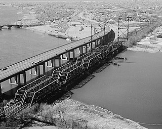
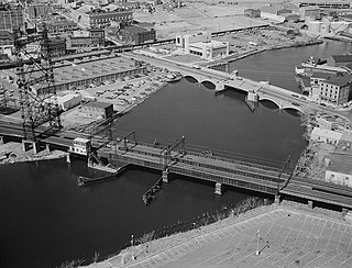
The Bulkeley Bridge is the oldest of three highway bridges over the Connecticut River in Hartford, Connecticut. A stone arch bridge composed of nine spans, the bridge carries Interstate 84, U.S. Route 6, and U.S. Route 44 across the river, connecting Hartford to East Hartford. As of 2005 the bridge carried an average daily traffic of 142,500 cars. The arches are mounted on stone piers, and vary in length from 68 feet (21 m) to 119 feet (36 m); the total length of the bridge is 1,192 feet (363 m).
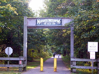
The Farmington Canal, also known as the New Haven and Northampton Canal, was a major private canal built in the early 19th century to provide water transportation from New Haven into the interior of Connecticut, Massachusetts and beyond. Its Massachusetts segment was known as the Hampshire and Hampden Canal. With the advent of railroads, it was quickly converted to a railroad in the mid-19th century and in recent years has been converted to a multi-use trail after being abandoned for years.

Windsor is a historic railroad station on Amtrak's New Haven–Springfield Line, located in downtown Windsor, Connecticut. It is served by Amtrak Northeast Regional and Valley Flyer intercity service and CTrail's Hartford Line commuter rail service. The nearby Hartford & New Haven Railroad-Freight Depot serves as the home of the Windsor Arts Center.

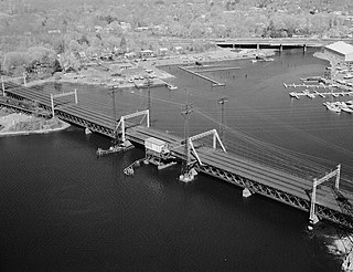
Windsor Locks station is an Amtrak and CTrail train station in Windsor Locks, Connecticut, on the New Haven–Springfield Line. It is served by four Amtrak services - the Hartford Line shuttles, Northeast Regional, Valley Flyer, and Vermonter - as well as CTrail Hartford Line commuter rail trains.
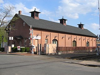
The Hartford & New Haven Railroad Freight Depot is a historic building at 40 Mechanic Street in downtown Windsor, Connecticut, across the street from the equally historic Hartford & New Haven Railroad Depot. Built about 1870, it is a well-preserved example of a Gothic Revival freight depot. It was listed on the National Register of Historic Places in 1988. It is now the home of the Windsor Arts Center, a non-profit place that exhibits the work of visual and performing artists.
The Housatonic River Railroad Bridge is a historic bridge carrying Metro-North Railroad's New Haven Line trackage across the lower Housatonic River in the U.S. state of Connecticut. The bridge is also used by Amtrak for its Northeast Corridor services. It was listed on the National Register of Historic Places in 1987, which also refers to the bridge as the Devon Bridge. It is also referred to as the Devon Railroad Bridge by the state Department of Environmental Protection.

The Amtrak Old Saybrook – Old Lyme Bridge is the last crossing of the Connecticut River before it reaches Long Island Sound. It is a Truss bridge with a bascule span, allowing boat traffic to go through. Its tracks are owned by Amtrak and used by Northeast Regional, Acela Express, Shore Line East trains traversing the Northeast Corridor. It can be seen from the Raymond E. Baldwin Bridge, as well as from various points on Route 154.

The Norwalk River Railroad Bridge is a swing bridge built in 1896 for the New York, New Haven and Hartford Railroad. It currently carries Amtrak and Metro-North Railroad trains over the Norwalk River.

The River Road Stone Arch Railroad Bridge is a historic bridge carrying the former Air Line Railroad right-of-way over River Road in Salmon River State Forest in Colchester, Connecticut. Built in 1887, it is a well-preserved example of a period masonry railroad bridge, built as part of a state-mandated program for the reduction of the number of grade crossings in the state. The bridge was listed on the National Register of Historic Places in 1986.
The Mianus River Railroad Bridge, also known as the Cos Cob Bridge, is a bascule bridge built in 1904 over the Mianus River, in Greenwich, Connecticut. It was listed on the National Register of Historic Places in 1987. The bridge carries the Northeast Corridor, the busiest rail line in the United States, both in terms of ridership and service frequency. It is operated by the Metro-North Railroad, successor to Conrail, Penn Central, and the New York, New Haven and Hartford Railroad, which erected it, and is owned by the Connecticut Department of Transportation.
The Pequonnock River Railroad Bridge is a railroad drawbridge over the Pequonnock River in Bridgeport, Connecticut. Owned by the State of Connecticut and maintained and operated by both Amtrak and Metro-North Railroad, it is also referred to as Pequonnock River Bridge, PECK Bridge, and Undergrade Bridge 55.90. Currently the bridge is part of the Northeast Corridor line, carrying rail traffic of Amtrak and Metro-North, as well as freight trains operated by the Providence & Worcester Railroad.

The Pequabuck Bridge is a historic stone arch bridge, carrying a paved multiuse trail across the Pequabuck River in Farmington, Connecticut. Built in 1833, the bridge formerly carried the adjacent Meadow Road. It is one of the state's only surviving early 19th-century stone arch bridges and was listed on the National Register of Historic Places in 1984.

The Samuel Morey Memorial Bridge is a historic bridge carrying New Hampshire Route 25A across the Connecticut River between Orford, New Hampshire and Fairlee, Vermont. The steel through-arch bridge was built in 1937–38 to replace an older wooden bridge which had been damaged by flooding in 1936. It spans 432 feet (132 m), stands about 35 feet (11 m) above the river, and its arches rise 85 feet (26 m) above the roadway. It rests on poured concrete abutments that have a light Art Deco or Moderne styling. Wing walls recede from the abutments into the banks in three stepped sections. Below the bridge in the river is visible some riprap, stone remnants of the old bridge's abutments and central pier. The bridge is of a "tied arch" design, in which the two arches are joined together by ties to distribute the active load. This is in contrast to the Justice Harlan Fiske Stone Bridge joining Brattleboro, Vermont and Chesterfield, New Hampshire, which was built about the same time, and distributes the active load to its abutments. The bridge components were manufactured by the American Bridge Company; construction was by Hagen-Thibodeau Construction Company at a contracted cost of just over $209,000.

Best's Covered Bridge(akaSwallow's Bridge) is a historic covered bridge in West Windsor, Vermont, that carries Churchill Road over Mill Creek, just south of Vermont Route 44. Built in 1889, it is an architecturally distinctive laminated arch structure with a post-and-beam superstructure. It was listed on the National Register of Historic Places in 1973.

The Ottauquechee River Bridge is a steel girder bridge carrying United States Route 5 across the Ottauquechee River in Hartland, Vermont. The bridge replaced a c. 1930 Warren deck truss bridge, built in the wake of Vermont's devastating 1927 floods, and listed on the National Register of Historic Places in 1990.

The Quechee Gorge Bridge is a historic bridge, carrying U.S. Route 4 (US 4) across Quechee Gorge, near the Quechee village of Hartford, Vermont. Built in 1911, it is Vermont's oldest surviving steel arch bridge. It was listed on the National Register of Historic Places in 1990.

The Broad Street Green Historic District encompasses the historic late-19th century town center of Windsor, Connecticut. It is centered around the Broad Street Green, a public park extending on the east side of Broad Street between Union and Batchelder Streets, and includes a diversity of architecture spanning much of the town's long history. It was listed on the National Register of Historic Places in 1999.

The Stone Bridge is a historic bridge in Hartford, Connecticut, carrying Main Street across the Whitehead Highway just south of the city's downtown. Built in 1833 across the Park River, it was the largest stone bridge in the United States at its completion. It was listed on the National Register of Historic Places in 1985.


