Felixstowe Ferry

Last updated

Felixstowe Ferry
Felixstowe Ferry - village sign - geograph.org.uk - 449842.jpg
Felixstowe Ferry village sign
Suffolk UK location map.svg
Red pog.svg
Felixstowe Ferry
Location within Suffolk
Shire county
Region
Country England
Sovereign state United Kingdom
List of places
UK
England
Suffolk
51°59′20″N1°23′24″E / 51.989°N 1.39°E / 51.989; 1.39 Coordinates: 51°59′20″N1°23′24″E / 51.989°N 1.39°E / 51.989; 1.39
A Martello Tower and the River Deben at Felixstowe Ferry in June 2019 Cmglee Felixstowe Ferry promontory.jpg
A Martello Tower and the River Deben at Felixstowe Ferry in June 2019

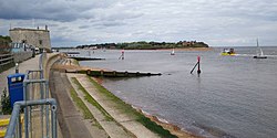
Felixstowe Ferry is a hamlet in Suffolk, England, approximately two miles northeast of Felixstowe at the mouth of the River Deben with a ferry to the Bawdsey peninsula.

Contents

Two Martello towers dominate the sea front.

The Felixstowe Ferry Millennium Green Trust was set up in 2001 to save an area of land from building development and put it to use as a community open space for recreational use. [1] [2] The land became known as the Millennium Green.

See also

Related Research Articles

The Suffolk Coast Path is a long-distance footpath along the Suffolk Heritage Coast in England. It is 50 miles (80 km) long.

Felixstowe Human settlement in England

Felixstowe is a seaside town in Suffolk, England. The estimated population in 2017 was 24,521. The Port of Felixstowe is the largest container port in the United Kingdom.

Orford Ness Coastal shingle spit in Suffolk, England

Orford Ness is a cuspate foreland shingle spit on the Suffolk coast in Great Britain, linked to the mainland at Aldeburgh and stretching along the coast to Orford and down to North Weir Point, opposite Shingle Street. It is divided from the mainland by the River Alde, and was formed by longshore drift along the coast. The material of the spit comes from places further north, such as Dunwich. Near the middle point of its length, at the foreland point or 'Ness', once stood Orfordness Lighthouse, demolished in summer 2020 due to the encroaching sea. In the name of the lighthouse, 'Orfordness' is written as one word.

Trimley railway station Railway station in Suffolk, England

Trimley railway station is on the Felixstowe Branch Line in the east of England, serving the village of Trimley St. Mary, Suffolk. It is 14 miles 5 chains (22.6 km) down the line from Ipswich and 82 miles 64 chains (133.3 km) measured from London Liverpool Street; it is situated between Derby Road and Felixstowe. Its three-letter station code is TRM.

Bawdsey Human settlement in England

Bawdsey is a village and civil parish in Suffolk, eastern England. Located on the other side of the river Deben from Felixstowe, it had an estimated population of 340 in 2007, reducing to 276 at the Census 2011.

Darsham Human settlement in England

Darsham is a village in Suffolk, England. It is located approximately 4 miles (6 km) north east of Saxmundham. The village is bypassed by the A12 and is served by Darsham railway station, which is approximately one mile away from the village centre, on the Ipswich-Lowestoft East Suffolk Line.

Walton, Suffolk Human settlement in England

Walton is a settlement and former civil parish in the East Suffolk district, in the county of Suffolk, England, lying between the rivers Orwell and Deben. It is now part of Felixstowe parish. In 1911 the parish had a population of 4226.

Alderton, Suffolk Human settlement in England

Alderton is a village and civil parish in the East Suffolk district of Suffolk, England, about six miles north of Felixstowe, 10 miles south-east of Woodbridge and 2 miles south of Hollesley, on the North Sea coast and in the heart of the Suffolk Coast and Heaths Area of Outstanding Natural Beauty. In 2007 its population was 430, reducing to 423 at the 2011 Census.

The Port of Felixstowe Police is a non-Home Office ports police force established in 1975, responsible for policing the Port of Felixstowe in Felixstowe, Suffolk, United Kingdom.

River Deben River in Suffolk, England

The River Deben is a river in Suffolk rising to the west of Debenham, though a second, higher source runs south from the parish of Bedingfield. The river passes through Woodbridge, turning into a tidal estuary before entering the North Sea at Felixstowe Ferry. The mouth of the estuary is crossed by a ferry connecting Felixstowe and Bawdsey.

Dommoc

Dommoc, a place not certainly identified but probably within the modern county of Suffolk, was the original seat of the Anglo-Saxon bishops of the Kingdom of East Anglia. It was established by Sigeberht of East Anglia for Saint Felix in c. 629–31. It remained the bishopric of all East Anglia until c. 673, when Theodore of Tarsus, Archbishop of Canterbury, divided the see and created a second bishopric at either North Elmham, Norfolk, or South Elmham, Suffolk. The see of Dommoc continued to exist until the time of the Viking Wars of the 860s, after which it lapsed.

National Cycle Route 51 is an English long distance cycle route running broadly east-west connecting Colchester and the port of Harwich to Oxford via Ipswich, Bury St Edmunds, Cambridge, Bedford, Milton Keynes, Bicester, and Kidlington.

Regional Cycle Route 41 in Suffolk runs from Snape to Bramfield through the Suffolk Coast and Heaths, an Area of Outstanding Natural Beauty.

The ferries in Suffolk are a series of local ferry services in the county of Suffolk in Eastern England. Most cross rivers within the county, although some connect Suffolk with Essex to the south.

Bawdsey Manor

Bawdsey Manor stands at a prominent position at the mouth of the River Deben close to the village of Bawdsey in Suffolk, England, about 75 miles (120 km) northeast of London. Built in 1886, it was enlarged in 1895 as the principal residence of Sir William Cuthbert Quilter. Requisitioned by the Devonshire Regiment during World War I and having been returned to the Quilter family after the war, it was purchased by the Air Ministry for £24,000 in 1936 to establish a new research station for developing the Chain Home RDF (radar) system. RAF Bawdsey was a base through the Cold War until the 1990s. The manor is now used by PGL for courses and children's holidays. There is a small museum in the radar transmitter block.

Pulhamite Material simulating natural stone

Pulhamite was a patented anthropic rock material invented by James Pulham (1820–1898) of the firm James Pulham and Son of Broxbourne in Hertfordshire. It was widely used for rock gardens and grottos.

Sir Cuthbert Quilter, 1st Baronet British politician

Sir William Cuthbert Quilter, 1st Baronet was an English stock broker, art collector and Liberal/Liberal Unionist politician who sat in the House of Commons from 1885 to 1906.

Felixstowe Ferry Golf Club Golf club in Suffolk, England

The Felixstowe Ferry Golf Club is in Felixstowe, Suffolk, England.

Bawdsey Cliff

Bawdsey Cliff is a 17.4 hectare geological Site of Special Scientific Interest north-east of Felixstowe in Suffolk. It is a Geological Conservation Review site, and is in the Suffolk Coast and Heaths Area of Outstanding Natural Beauty.

References

Commons-logo.svg Media related to Felixstowe Ferry at Wikimedia Commons