Yosemite Valley is a glacial valley in Yosemite National Park in the western Sierra Nevada mountains of Central California, United States. The valley is about 7.5 mi (12.1 km) long and 3,000–3,500 ft (910–1,070 m) deep, surrounded by high granite summits such as Half Dome and El Capitan, and densely forested with pines. The valley is drained by the Merced River, and a multitude of streams and waterfalls flow into it, including Tenaya, Illilouette, Yosemite and Bridalveil Creeks. Yosemite Falls is the highest waterfall in North America and is a big attraction, especially in the spring, when the water flow is at its peak. The valley is renowned for its natural environment and is regarded as the centerpiece of Yosemite National Park.

State Route 1 (SR 1) is a major north–south state highway that runs along most of the Pacific coastline of the U.S. state of California. At 656 miles (1,056 km), it is the longest state route in California, and the second-longest in the US after Montana Highway 200. SR 1 has several portions designated as either Pacific Coast Highway (PCH), Cabrillo Highway, Shoreline Highway, or Coast Highway. Its southern terminus is at Interstate 5 (I-5) near Dana Point in Orange County and its northern terminus is at U.S. Route 101 (US 101) near Leggett in Mendocino County. SR 1 also at times runs concurrently with US 101, most notably through a 54-mile (87 km) stretch in Ventura and Santa Barbara counties, and across the Golden Gate Bridge.

Mariposa County is a county located in the U.S. state of California. As of the 2020 U.S. Census, the population was 17,131. The county seat is Mariposa. It is located in the western foothills of the Sierra Nevada mountains, north of Fresno, east of Merced, and southeast of Stockton.

Mariposa is an unincorporated community and census-designated place (CDP) in and the county seat of Mariposa County, California, United States. The population was 1,526 at the 2020 census. Named for the monarch butterflies that overwinter there, the community's history is deeply intertwined with the California Gold Rush of the 19th century.

State Route 140 is a state highway in the U.S. state of California, 102 miles (164 km) in length. It begins in the San Joaquin Valley at Interstate 5 near Gustine, and runs east into Sierra Nevada, terminating in Yosemite National Park.
Mariposa Grove is a sequoia grove located near Wawona, California, United States, in the southernmost part of Yosemite National Park. It is the largest grove of giant sequoias in the park, with several hundred mature specimens. Two of its trees are among the 30 largest giant sequoias in the world. The grove attracts about one million visitors annually.

Human habitation in the Sierra Nevada region of California reaches back 8,000 to 10,000 years ago. Historically attested Native American populations, such as the Sierra Miwok, Mono and Paiute, belong to the Uto-Aztecan and Utian phyla. In the mid-19th century, a band of Native Americans called the Ahwahnechee lived in Yosemite Valley. The California Gold Rush greatly increased the number of non-indigenous people in the region. Tensions between Native Americans and white settlers escalated into the Mariposa War. As part of this conflict, settler James Savage led the Mariposa Battalion into Yosemite Valley in 1851, in pursuit of Ahwaneechees led by Chief Tenaya. The California state military forces burned the tribe's villages, destroyed their food stores, killed the chief's sons, and forced the tribe out of Yosemite. Accounts from the Mariposa Battalion, especially from Dr. Lafayette Bunnell, popularized Yosemite Valley as a scenic wonder.

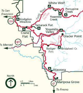
Tenaya Lake is an alpine lake in Yosemite National Park, located between Yosemite Valley and Tuolumne Meadows. The surface of Tenaya Lake has an elevation of 8,150 feet (2,484 m). The lake basin was formed by glacial action, which left a backdrop of light granite rocks, whose beauty was known to the Native Americans. Today, Tenaya Lake is easily accessible by State Route 120 and is a popular lake for water activities.

State Route 41 is a state highway in the U.S. State of California, connecting the Central Coast with the San Joaquin Valley and the Sierra Nevada. Its southern terminus is at the Cabrillo Highway in Morro Bay, and its northern terminus is at SR 140 in Yosemite National Park. It has been constructed as an expressway from near SR 198 in Lemoore north to the south part of Fresno, where the Yosemite Freeway begins, passing along the east side of downtown and extending north into Madera County.

Yosemite West is an unincorporated community and census-designated place (CDP) of resort homes located just outside the southern area of Yosemite National Park, just off Wawona Road, a continuation of State Route 41 from Fresno. It is a census-designated place (CDP), with a population of 47 as of the 2020 census. It is situated one mile (1.6 km) south of the Chinquapin intersection of Wawona Road with Glacier Point Road, at an altitude of 5,100 to 6,300 feet. The elevation reported by the USGS is 5,866 feet (1,788 m). The community is part of Henness Ridge, nearly 3,000 feet (910 m) above the southern banks of the Merced River and State Route 140 from Mariposa. Addresses in this area are shown as "Yosemite National Park, CA 95389".

Camp Curry, now known as Curry Village, was established in 1899 at the base of Glacier Point in Yosemite National Park. Developed as an alternative to the first-class Sentinel Hotel, it offered a more affordable, rustic lodging experience. The camp became an iconic part of Yosemite's history, known for its family-oriented atmosphere, nightly campfires, signature tent cabins, and the reinstitution of the Yosemite Firefall. Camp Curry’s success helped lay the foundation for modern park accommodations and had a lasting influence on the development of national park concessions.

The Yosemite Valley Railroad (YVRR) was a short-line railroad that operated in California from 1907 to 1945, providing a new mode of travel and tourism for the region. It ran from Merced to the Yosemite National Park, but it did not extend to Yosemite Valley itself, as railroad construction was prohibited in the National Parks. Tourists would disembark at the park boundary in El Portal, California and stay overnight at the Hotel Del Portal before taking a stagecoach to Yosemite Valley.

The Yosemite Area Regional Transportation System (YARTS) is a public transit bus line based in Merced, California providing scheduled fixed route service between Yosemite National Park and gateway communities. Service operates year-round on Highway 140, providing access to Merced and Mariposa counties. During the peak summer months, additional service is added along Highway 120 providing access to Tuolumne County, Highway 41 providing access to Fresno and Madera counties, and eastern Highway 120/US 395 providing access to Mono County.

The January 1997 flood of the Merced River occurred from December 31, 1996, to January 5, 1997, throughout the Yosemite Valley in Yosemite National Park, Mariposa County, California, US. The flood stands as arguably the park's worst natural disaster to date, and inarguably the worst flood in park history. The Merced River at Happy Isles peaked at 10,100 cubic feet per second during the flood. A book was written on the flood later in 1997 by Mark Goodin titled Yosemite: The 100-Year Flood. It is part of the 1997 California New Years Floods.

The 1996 Yosemite Valley landslide occurred on July 10, 1996, near the Happy Isles trailhead in Yosemite Valley, Yosemite National Park, Mariposa County, California. 162,000 tons of rocks and other debris fell to the ground at over 160 miles per hour. Of the 12 campers/hikers involved in the incident, one was killed. The landslide competes with the 1997 Merced River flood and the 2013 Rim wildfire for the designation of the worst natural disaster in Yosemite to date. The earthquake caused by the rock slide was followed almost immediately by a sonic boom. Soon afterward a granite dust mushroom cloud formed over Happy Isles. The immense pressure created at the base of the rock slide blew down giant pine trees. Afterwards the nearby campground tables and trees were covered with a thick coat of granite dust.

The Yosemite Valley Bridges are eight bridges in the Yosemite Valley of Yosemite National Park, most of them spanning the Merced River. Five of them were built in 1928, with the remainder built between 1921 and 1933. The bridges feature a concrete structure faced with local stone, in an elliptical or three-centred arch configuration. They are notable for their uniform character and for their conformance to tenets of the National Park Service rustic style. Design work for the seven newer bridges was by George D. Whittle of the San Francisco District Office of the U.S. Bureau of Public Roads for the National Park Service. Concrete bridges were chosen at the urging of Thomas Chalmers Vint of the Park Service, in lieu of alternative designs for steel truss bridges, or suspension bridges suggested by the park superintendent.

The Tom Lantos Tunnels are two tunnels located within the coastal promontory of Montara Mountain, on the San Francisco Peninsula in California, United States, created to allow rerouting State Route 1 to avoid a portion of roadway known as Devil's Slide. They are officially named after late Congressman Tom Lantos, who was instrumental in securing funding for the project, but de facto named after their location.

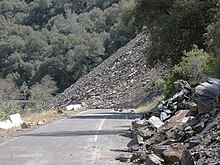
A rock shed is a civil engineering structure used in mountainous areas where rock slides and land slides create highway closure problems. A rock shed is built over a roadway that is in the path of the slide. They are equally used to protect railroads. They are usually designed as a heavy reinforced concrete covering over the road, protecting the surface and vehicles from damage due to the falling rocks with a sloping surface to deflect slip material beyond the road, however an alternative is to include an impact-absorbing layer above the ceiling. A further use of this type of structure may be seen protecting the A4 road; although constructed primarily to alleviate risk from falling rocks from a limestone seam it also serves to protect against objects or persons falling from the Clifton Suspension Bridge where the height differential of approximately 70 metres from the bridge to the bottom of the Avon Gorge would give sufficient kinetic energy to even a relatively small item to cause injury on impact.

The Ferguson Fire was a major wildfire in the Sierra National Forest, Stanislaus National Forest and Yosemite National Park in California in the United States. The fire was reported on July 13, 2018, burning 96,901 acres (392 km2), before it was 100% contained on August 19, 2018. Interior areas of the fire continued to smolder and burn until September 19, 2018, when InciWeb declared the fire to be inactive. The Ferguson Fire was caused by the superheated fragments of a faulty vehicle catalytic converter igniting vegetation. The fire, which burned mostly in inaccessible wildland areas of the national forest, impacted recreational activities in the area, including in Yosemite National Park, where Yosemite Valley and Wawona were closed. The Ferguson Fire caused at least $171.2 million in damages, with a suppression cost of $118.5 million and economic losses measuring $52.7 million. Two firefighters were killed and nineteen others were injured in the fire.
Big Sur Coast Highway is a section of California State Route 1 through the Big Sur region of California that is widely considered to be one of the most scenic driving routes in the United States, if not the world. It is both a National Scenic Highway and a California Scenic Highway, and was described by Australian painter Francis McComas as the "greatest meeting of land and water in the world". Condé Nast Traveler named State Route 1 through Big Sur one of the top ten world-famous streets, comparable to Broadway in New York City and the Champs-Élysées in Paris. The road itself is a destination for visitors.