The Fezzan-Ghadames Military Territory was a territory in the southern part of Italian Libya which was occupied and administered by Free France from 1943 until Libya gained independence in 1951. It was part of the allied occupation of Libya.
Free French forces from French Chad occupied the area that was the former Italian Southern Military Territory in 1943,[2] and made several requests to annex Fezzan administratively to France's North African possessions.
The British administration began the training of a badly needed Libyan civil service. Italian administrators continued to be employed in Tripoli, however. The Italian legal code remained in effect for the duration of the war. In the lightly populated Fezzan region, a French military administration formed a counterpart to the British operation. With British approval, Free French forces moved north from Chad to take control of the territory in January 1943. French administration was directed by a staff stationed in Sabha, but it was largely exercised through Fezzan notables of the family of Sayf an Nasr. At the lower echelons, French troop commanders acted in both military and civil capacities according to customary French practice in the Algerian Sahara. In the west, Ghat was attached to the French military region of southern Algeria and Ghadamis to the French command of southern Tunisia – giving rise to Libyan nationalist fears that French intentions might include the ultimate detachment of Fezzan from Libya.[3]
Fezzan joined Tripolitania and Cyrenaica to form the Kingdom of Libya on 24 December 1951. It was the first country to achieve independence through the United Nations and one of the first former European possessions in Africa to gain independence.
Inauguration of a stele commemorating the capture of Sebha by the Free French Forces in 1943
Related Research Articles
High commissioner is the title of various high-ranking, special executive positions held by a commission of appointment.
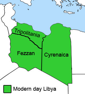
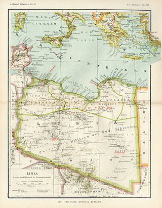
Fezzan is the southwestern region of modern Libya. It is largely desert, but broken by mountains, uplands, and dry river valleys (wadis) in the north, where oases enable ancient towns and villages to survive deep in the otherwise inhospitable Sahara Desert. The term originally applied to the land beyond the coastal strip of Africa proconsularis, including the Nafusa and extending west of modern Libya over Ouargla and Illizi. As these Berber areas came to be associated with the regions of Tripoli, Cirta or Algiers, the name was increasingly applied to the arid areas south of Tripolitania.
Tripolitania, historically known as the Tripoli region, is a historic region and former province of Libya.
Ghat is the capital of the Ghat District in the Fezzan region of southwestern Libya, located just east of the Algerian border.
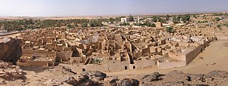
Murzuk, Murzuq, Murzug or Merzug is an oasis town and the capital of the Murzuq District in the Fezzan region of southwest Libya. It lies on the northern edge of the Murzuq Desert, an extremely arid region of ergs or great sand dunes which is part of the greater Sahara Desert.
Chad was a part of the French colonial empire from 1900 to 1960. Colonial rule under the French began in 1900 when the Military Territory of Chad was established. From 1905, Chad was linked to the federation of French colonial possessions in Middle Africa, known from 1910 under the name of French Equatorial Africa. Chad passed in 1920 to French civilian administration, but suffered from chronic neglect.
Subdivisions of Libya have varied significantly over the last two centuries. Initially Libya under Ottoman and Italian control was organized into three to four provinces, then into three governorates (muhafazah) and after World War II into twenty-five districts (baladiyah). Successively into thirty-two districts (shabiyat) with three administrative regions, and then into twenty-two districts (shabiyat). In 2012 the ruling General National Congress divided the country into governorates (muhafazat) and districts (baladiyat). While the districts have been created, the governorates have not.
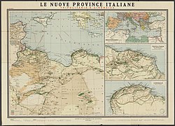
The Provinces of Libya were prescribed in 1934, during the last period of colonial Italian Libya, and continued through post-independence Libya until 1963 when the Governorates system was instituted.
Libya was a colony of Fascist Italy located in North Africa, in what is now modern Libya, between 1934 and 1943. It was formed from the unification of the colonies of Cyrenaica and Tripolitania, which had been Italian possessions since 1911.
Chad achieved independence in 1960. At the time, it had no armed forces under its own flag. Since World War I, however, southern Chad, particularly the Sara ethnic group, had provided a large share of the Africans in the French army. Chadian troops also had contributed significantly to the success of the Free French Forces in World War II. In December 1940, two African battalions began the Free French military campaign against Italian forces in Libya from a base in Chad, and at the end of 1941, a force under Colonel Jacques Leclerc participated in a spectacular campaign that seized the entire Fezzan region of southern Libya. Colonel Leclerc's 3,200-man force included 2,700 Africans, the great majority of them southerners from Chad. These troops went on to contribute to the Allied victory in Tunisia. Chadians, in general, were proud of their soldiers' role in the efforts to liberate France and in the international conflict.
The Italian colonial empire, also known as the Italian Empire between 1936 and 1941, was founded in Africa in the 19th century and it comprised the colonies, protectorates, concessions and dependencies of the Kingdom of Italy. In Africa, the colonial empire included the territories of present-day Libya, Eritrea, Somalia and Ethiopia ; outside Africa, Italy possessed the Dodecanese Islands, Albania and also had a concession in Tianjin, China.
This is a survey of the postage stamps and postal history of Libya. Libya is a country located in North Africa. Bordering the Mediterranean Sea to the north, Libya lies between Egypt to the east, Sudan to the southeast, Chad and Niger to the south, and Algeria and Tunisia to the west.
This is a survey of the postage stamps and postal history of Fezzan and Ghadames, both now part of Libya.
The Allied administration of Libya was the control of the ex-colony of Italian Libya by the Allies from 13 May 1943 until Libyan independence was granted in 1951. It was divided into two parts:
The British Military Administration of Libya was the control of the regions of Cyrenaica and Tripolitania of the former Italian Libya by the British from 1943 until Libyan independence in 1951. It was part of the Allied administration of Libya.
The Southern Military Territory was a jurisdictional territory within the colony of Italian Libya (1911–1947), administered by the Italian military in the Libyan Sahara.
The Fourth Shore or Italian North Africa was the name created by Benito Mussolini to refer to the Mediterranean shore of coastal colonial Italian Libya and, during World War II, Italian Tunisia in the fascist-era Kingdom of Italy, during the late Italian colonial period of Libya and the Maghreb.
The Libya–Niger border is 342 kilometres in length and runs from the tripoint with Algeria in the west to the tripoint with Chad in the east.
Libyan nationality law is regulated by the Constitution of Libya, as amended; the Libyan Nationality Law, and its revisions; and various international agreements to which the country is a signatory. These laws determine who is, or is eligible to be, a national of Libya. The legal means to acquire nationality, formal legal membership in a nation, differ from the domestic relationship of rights and obligations between a national and the nation, known as citizenship. Nationality describes the relationship of an individual to the state under international law, whereas citizenship is the domestic relationship of an individual and the nation. Libyan nationality is typically obtained under the principle of jus soli, i.e. by birth in Libya, or jus sanguinis, born to parents with Libyan nationality. It can be granted to persons with an affiliation to the country, or to a permanent resident who has lived in the country for a given period of time through naturalization.
This page is based on this Wikipedia article Text is available under the CC BY-SA 4.0 license; additional terms may apply. Images, videos and audio are available under their respective licenses.