Figueroa Street Tunnels

Last updated
Figueroa Street Tunnels
FigueroaStTunnels.jpg
Looking northeast through the third and fourth tunnels
Overview
Location Elysian Park, Los Angeles
Coordinates 34°04′23″N118°14′02″W / 34.07306°N 118.23389°W / 34.07306; -118.23389
RouteNorthbound lanes of California 110.svg SR 110
StartNortheast of Stadium Way
EndSouthwest of I-5 (1961).svg I-5
Operation
Opened1931
Operator Caltrans
Technical
Length755, 461, 130, and 405 ft (230, 141, 40, and 123 m, respectively)
Tunnel clearance 28.3 ft (8.6 m)
Width46.5 feet (14 m)
Route map
Figueroa Street Tunnels

The Figueroa Street Tunnels are a set of four four-lane tunnels that carry northbound traffic on State Route 110 (the Arroyo Seco Parkway) through Elysian Park in Los Angeles, California, United States. From south to north, the four tunnels measure 755, 461, 130, and 405 feet (230, 141, 40, and 123 m) in length, 46.5 feet (14 m) in width, and 28.3 ft (8.6 m) in height. [1]

Contents

The north three tunnels opened in 1931 as a bypass to a section of North Broadway; the southernmost (and longest) opened in 1935, connecting to Figueroa Street downtown. In 1943, the Figueroa Street Viaduct was built to the north of the tunnels. This dedicated the tunnels to 4 lanes of eastward traffic, and the viaduct to 4 lanes of westward traffic. Several connections have been added to the street, most notably in 1940 to the Arroyo Seco Parkway and in 1953 to the Four Level Interchange.

The tunnels were designed by engineer Merrill Butler, who was responsible for many iconic Los Angeles River bridges - notably the Sixth Street Viaduct and the Glendale-Hyperion Bridge. The tunnels featured Art Deco patterns, ornamental street lamps, reflective tiling (similar to the 2nd Street Tunnel), and above all eight openings, a stylized Seal of Los Angeles. [2]

Traffic through the tunnels is heavy at almost all times of day. At the north end of the tunnels is an interchange with Interstate 5 (Golden State Freeway), in which the leftmost lane makes a hard turn onto the offramp. There are also sharp exit and entrance ramps, on the right lane, at Solano Avenue after the first tunnel. Since the tunnels' incorporation into Arroyo Seco Parkway (now SR 110), Figueroa Street has been discontinuous. It merges into SR 110 at Alpine Street in Chinatown, south of the tunnels, and splits in Highland Park, north of the Figueroa Street Viaduct over the Los Angeles River.

History

Circa 1911, traffic between Los Angeles and Pasadena crossed the Los Angeles River on the congested North Broadway Bridge, the largest concrete bridge in California at the time. [3] [4] The Dayton Avenue Bridge provided another crossing to the north, but the hills of Elysian Park prevented it from being connected to downtown. The north three tunnels opened by November 1, 1931, connecting to North Broadway on the south via Solano Avenue and Riverside Drive on the north. Riverside Drive was an earlier high-speed road along the Los Angeles River to Burbank, and also intersected the Dayton Avenue Bridge, which led to Dayton Avenue (now part of Figueroa Street) towards Pasadena. From opening, the tunnels carried two lanes in each direction, with a 5-foot (1.5 m) sidewalk on the side. [5]

The fourth tunnel opened on August 4, 1936, continuing the route south and southwest to Figueroa Street at Alpine Street. (Bridges over Figueroa Street on Temple Street and First Street were built in 1940, further improving that entrance to downtown.) The Figueroa Street Viaduct opened in 1937, providing a wider and direct Los Angeles River crossing than the Dayton Avenue Bridge. After passing over the river and San Fernando Road, it tied into Dayton Avenue (Figueroa Street) south of Avenue 26. [6] The Arroyo Seco Parkway opened in late 1940 as a freeway from the Viaduct to Pasadena. However, the six-lane parkway narrowed to four lanes at the viaduct and through the tunnels, and had a number of at-grade intersections on its way downtown.

The Southerly Extension of the Arroyo Seco Parkway supplemented the Figueroa Street Viaduct and Tunnels with a new southbound roadway to the west, and converted Figueroa Street to freeway standards south to Adobe Street. The new Los Angeles River Bridge left the existing road north of the original viaduct terminus at Figueroa Street, and crossed over the ramp to Figueroa Street, the Los Angeles River, and the northbound exit to Riverside Drive (now a ramp to Interstate 5 north, although Riverside Drive is still accessible from this ramp). Through Elysian Park, it was built higher than the tunnels, with open-cuts through the ridges through which the older tunnels were built, and viaducts over the valleys between the ridges. South of the southernmost tunnel, the older road was widened and upgraded to freeway standards south to Adobe Street. This new road opened December 30, 1943. [7] A further extension was completed on September 22, 1953 to the Four Level Interchange with U.S. Route 101 (Santa Ana Freeway and Hollywood Freeway). [8]

The tunnels (and Figueroa Street north of them) were part of pre-1964 Legislative Route 165, defined in 1933. By 1942, U.S. Route 6, U.S. Route 66, U.S. Route 99 and State Route 11 were signed through them. US 66 continued along the Arroyo Seco Parkway, while US 6 and US 99 turned northwest on San Fernando Road via Figueroa Street and Avenue 26, and SR 11 exited at Figueroa Street to run to Pasadena with U.S. Route 66 Alternate. [9] [10] US 99 moved to the new Golden State Freeway, bypassing the tunnels with Interstate 5, when it opened in 1962. US 6 and US 66 were removed from the Los Angeles area in the 1964 renumbering, leaving only SR 11 through the tunnels (and on the Parkway after 1964). SR 11 became State Route 110 in 1981, when the Harbor Freeway section of it became Interstate 110.

In April, 2008, retrofitting of the tunnel lighting was completed, replacing the tandem fluorescent lighting arrangement in place since 1964, with a more efficient lighting array.

Featured in the 1971 film Duel , in the begin credits sequence.

Seen in the end credits of the 1995 PlayStation video game Twisted Metal

In the 2005 film Rumor Has It… , three of the characters hold their breaths while driving through the tunnels.

At Disney's Hollywood Studios at Walt Disney World, a replica of the tunnel is used as the gateway from the Grand Avenue area to Star Wars: Galaxy's Edge.

See also

Related Research Articles

<span class="mw-page-title-main">Parkway</span> Landscaped thoroughfare

A parkway is a landscaped thoroughfare. The term is particularly used for a roadway in a park or connecting to a park from which trucks and other heavy vehicles are excluded.

<span class="mw-page-title-main">Arroyo Seco Parkway</span> Highway in California

The Arroyo Seco Parkway, also known as the Pasadena Freeway, is one of the oldest freeways built in the United States. The parkway connects Los Angeles with Pasadena alongside the Arroyo Seco seasonal river. It is notable not only for being an early freeway, mostly opened in 1940, but for representing the transitional phase between early parkways and later freeways. It conformed to modern standards when it was built, but is now regarded as a narrow, outdated roadway. A 1953 extension brought the south end to the Four Level Interchange in downtown Los Angeles and a connection with the rest of the freeway system.

<span class="mw-page-title-main">Interstate 110 and State Route 110 (California)</span> Interstate and state highway in California

Route 110, consisting of State Route 110 (SR 110) and Interstate 110 (I-110), is a state and auxiliary Interstate Highway in the Los Angeles metropolitan area of the US state of California. The entire route connects San Pedro and the Port of Los Angeles with Downtown Los Angeles and Pasadena. The southern segment from San Pedro to I-10 in downtown Los Angeles is signed as I-110, while the northern segment to Pasadena is signed as SR 110. The entire length of I-110, as well as SR 110 south of the Four Level Interchange with US Route 101 (US 101), is the Harbor Freeway, and SR 110 north from US 101 to Pasadena is the historic Arroyo Seco Parkway, the first freeway in the western United States.

<span class="mw-page-title-main">Ventura Freeway</span> Freeway in Southern California

The Ventura Freeway is a freeway in southern California, United States, that runs from the Santa Barbara/Ventura county line to Pasadena in Los Angeles County. It is the principal east–west route through Ventura County and in the southern San Fernando Valley in Los Angeles County. From the Santa Barbara County line to its intersection with the Hollywood Freeway in the southeastern San Fernando Valley in Los Angeles, it is signed as U.S. Route 101 (US 101), which was built in the late 1950s and opened on April 5, 1960. The segments from the Santa Barbara County line to Sea Cliff, and from Solimar Beach to Oxnard, are also concurrent with State Route 1 (SR 1), although no signs mention SR 1 there. East of the Hollywood Freeway intersection, the Ventura Freeway is signed as State Route 134 (SR 134), which was built by 1971.

<span class="mw-page-title-main">Highland Park, Los Angeles</span> Neighborhood of Los Angeles in California, United States

Highland Park is a neighborhood in Los Angeles, California, located in the city's Northeast region. It was one of the first subdivisions of Los Angeles and is inhabited by a variety of ethnic and socioeconomic groups.

<span class="mw-page-title-main">Four Level Interchange</span> Stack interchange in Los Angeles

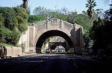
The Four Level Interchange is the first stack interchange in the world. Completed in 1949 and fully opened in 1953 at the northern edge of Downtown Los Angeles, California, United States, it connects U.S. Route 101 to State Route 110. In 2006, the interchange was officially renamed in the memory of Los Angeles traffic and weather reporter Bill Keene.

<span class="mw-page-title-main">Colorado Boulevard</span> Major east–west street in Los Angeles County, Southern California

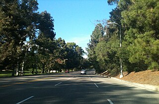
Colorado Boulevard is a major east–west street in Southern California. It runs from Griffith Park in Los Angeles east through Glendale, the Eagle Rock section of Los Angeles, Pasadena, and Arcadia, ending in Monrovia. The full route was once various state highways but is now locally maintained in favor of the parallel Ventura Freeway and Foothill Freeway (I-210).

<span class="mw-page-title-main">California State Route 118</span> Highway in California

State Route 118 is a state highway in the U.S. state of California that runs west to east through Ventura and Los Angeles counties. It travels from State Route 126 at the eastern edge of Ventura immediately northwest of Saticoy, then through Saticoy, in Ventura County east to Interstate 210 near Lake View Terrace in Los Angeles. SR 118 crosses the Santa Susana Pass and the northern rim of the San Fernando Valley along its route.

<span class="mw-page-title-main">Southern California freeways</span> Freeway system

The Southern California freeways are a vast network of interconnected freeways in the megaregion of Southern California, serving a population of 23 million people. The Master Plan of Metropolitan Los Angeles Freeways was adopted by the Regional Planning Commission in 1947 and construction began in the early 1950s. The plan hit opposition and funding limitations in the 1970s, and by 2004, only some 61% of the original planned network had been completed.

<span class="mw-page-title-main">Arroyo Seco (Los Angeles County)</span> Seasonal watercourse and human settlement in US

The Arroyo Seco, meaning "dry stream" in Spanish, is a 24.9-mile-long (40.1 km) seasonal river, canyon, watershed, and cultural area in Los Angeles County, California. The area was explored by Gaspar de Portolà who named the stream Arroyo Seco as this canyon had the least water of any he had seen. During this exploration he met the Chief Hahamog-na (Hahamonga) of the Tongva Indians.

<span class="mw-page-title-main">L Line (Los Angeles Metro)</span> Former light rail line

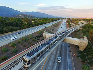
The L Line and Gold Line are former designations for a section of the current Los Angeles Metro Rail system. These names referred to a single light rail line of 31 miles (50 km) providing service between Azusa and East Los Angeles via the northeastern corner of Downtown Los Angeles, serving several attractions, including Little Tokyo, Union Station, the Southwest Museum, Chinatown, and the shops of Old Pasadena. The line, formerly one of seven in the system, entered service in 2003. The L Line served 26 stations.

<span class="mw-page-title-main">Elysian Park, Los Angeles</span> Neighborhood in Los Angeles, California

Elysian Park is a neighborhood in Central Los Angeles, California, United States. The city park, Elysian Park, and Dodger Stadium are within the neighborhood, as are an all-boys Catholic high school and an elementary school.

<span class="mw-page-title-main">California State Route 47</span> Highway in California

State Route 47 is a state highway in the U.S. state of California, connecting Terminal Island to the mainland in the Los Angeles area. From its south end at I-110 in San Pedro, it heads east across the Vincent Thomas Bridge to the island and the end of state maintenance. The state highway begins again at the junction with I-710 on Terminal Island, crossing the Schuyler Heim Bridge north to the mainland and the second terminus, where SR 103 begins. Signage continues along a locally maintained route, mainly Alameda Street, to the Gardena Freeway in Compton, and an unconstructed alignment follows the same corridor to the Santa Monica Freeway (I-10) near downtown Los Angeles.

<span class="mw-page-title-main">Figueroa Street</span> Street in Los Angeles County, California

Figueroa Street is a major north-south street in Los Angeles County, California, spanning from the Los Angeles neighborhood of Wilmington north to Eagle Rock. A short, unconnected continuation of Figueroa Street runs just south of Marengo Drive in Glendale to Chevy Chase Drive in La Cañada Flintridge.

<span class="mw-page-title-main">San Fernando Road</span> Major street in the City and County Los Angeles

San Fernando Road is a major street in the City of Los Angeles and Los Angeles County. Within the Burbank city limits it is signed as San Fernando Boulevard, and north of Newhall Pass it is signed as The Old Road. It was previously designated as Business Loop 5 in the 1970s.

<span class="mw-page-title-main">U.S. Route 66 in California</span> Highway in California

U.S. Route 66 is a part of a former United States Numbered Highway in the state of California that ran from the west in Santa Monica on the Pacific Ocean through Los Angeles and San Bernardino to Needles at the Arizona state line. It was truncated during the 1964 renumbering and its signage removed in 1974. The highway is now mostly replaced with several streets in Los Angeles, State Route 2 (SR 2), SR 110, SR 66, San Bernardino County Route 66 (CR 66), Interstate 15 (I-15), and I-40.

<span class="mw-page-title-main">Cypress Park, Los Angeles</span> Neighborhood of Los Angeles

Cypress Park is a densely populated neighborhood of 10,000+ residents in Northeast Los Angeles, California. Surrounded by hills on three sides, it sits in the valley created by the Los Angeles River and the Arroyo Seco. It is the site of the Rio de Los Angeles State Park, the Los Angeles River Bike Path and other recreational facilities. It hosts one private and four public schools.

<span class="mw-page-title-main">Garvanza, Los Angeles</span> Neighborhood of Los Angeles in California, United States

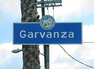
Garvanza is a neighborhood in northeast Los Angeles. Fourteen Los Angeles Historic-Cultural Monuments are located in the neighborhood.

<span class="mw-page-title-main">California Cycleway</span> Bike path in Southern California

The California Cycleway, opened in 1900, was a nine-mile (14 km) elevated tollway built specially for bicycle traffic through the Arroyo Seco, intended to connect the cities of Pasadena and Los Angeles, in California, United States.

<span class="mw-page-title-main">South Pasadena Local</span>

South Pasadena Local was a local streetcar line operated by the Pacific Electric Railway between Downtown Los Angeles and South Pasadena, California by way of the Arroyo Seco Route. This was one of four lines that connected the two cities.

References

  1. Historic American Engineering Record , Arroyo Seco Parkway ( PDF ), page 28
  2. Masters, Nathan (2014-07-14). "Before the 110 Freeway, Figueroa Street Ran Through These Tunnels". KCET. Retrieved 2020-11-02.
  3. Historic American Engineering Record , Arroyo Seco Parkway ( PDF ), page 53
  4. "North Broadway Bridge | Los Angeles Conservancy". www.laconservancy.org. Retrieved 2020-11-02.
  5. Historic American Engineering Record , Arroyo Seco Parkway ( PDF ), page 27-28
  6. Historic American Engineering Record , Arroyo Seco Parkway ( PDF ), page 53-54
  7. Historic American Engineering Record , Arroyo Seco Parkway ( PDF ), page 64
  8. Historic American Engineering Record , Arroyo Seco Parkway ( PDF ), page 65
  9. 1942 Gousha Los Angeles and vicinity map Archived April 24, 2006, at the Wayback Machine
  10. 1943 Los Angeles map Archived 2006-05-21 at the Wayback Machine