Areas
| | This section needs expansion. You can help by adding to it. (May 2019) |
Five Corners District is a management district covering sections of southern and Southwest Houston, Texas, United States.
The Texas Legislature created the district in 2007. [1] A business owner named Mehdi Banijamali stated that 25 property owners had signed to have the district created even though there were 1,400 property owners in its boundaries. [2]
On one occasion a group of business owners sued the district, and a settlement ended that suit; as part of the settlement the business owners no longer had their properties assessed. [3] Another suit was filed in 2012 with another group of business owners accusing the district organizers of deliberately excluding some businesses from the district. [2]
| | This section needs expansion. You can help by adding to it. (May 2019) |
The current Houston Police Department Southwest Patrol Division Station is located in Cambridge Village Park, within the Five Corners district. [5] The beginning of the construction was scheduled for February or March 2016 while the end of construction was scheduled for June–July 2017. It replaced a previous station inside the 610 Loop. [6] It has a total of 55,000 square feet (5,100 m2) of space, [5] including a 2,300-square-foot (210 m2) community room. [6] The cost was $21 million. [5]

Residents are in the Houston Independent School District. [7] Zoned middle schools serving sections of Five Corners include Attucks in Sunnyside, [8] Lawson (formerly Dowling) in Hiram Clarke, [9] Billy Reagan K-8, [10] Thomas, [11] and Welch in Fondren Southwest. [12] Zoned high schools serving sections of Five Corners include Madison High School and Worthing High School. [13] [14]
In 2019 Susie Tommaney, a contributing writer to the Houston Press , stated "Report cards from area schools are mixed" and that there were "Decent schools, including the area high school". [4]
St. Nicholas School (K-8) is an Anglican school. It will later occupy a new development on a 47-acre (19 ha) property along South Main Street. [15] [16]
The private school The Imani School is in Five Corners. [17]

South Park is a broad post-World War II development in the south-central area of Houston, Texas, a few miles south of MacGregor Park and directly south of the 610 Loop. According to the 2000 Census, the community has a population of 22,282. 81% of the South Park population is African American, compared to 25% for the city as a whole. Houston's Martin Luther King Boulevard runs through the area. Reflecting its postwar origins, many streets in South Park are named after World War II battle sites and persons. In the 1980s and 1990s crime became a key issue for South Park. Katharine Shilcutt of the Houston Press said "South Park is an overgrown garden these days, its soil only able to be tilled by the most determined or the most desperate. It shows no sign that it will grow again any time in the near future."

Sharpstown is a master-planned community in the Southwest Management District, Southwest Houston, Texas. It was one of the first communities to be built as a master-planned, automobile centered community and the first in Houston. Frank Sharp (1906–1993), the developer of the subdivision, made provisions not only for homes but also for schools, shopping and recreation areas. While this model has been duplicated countless times in the past fifty years, at the time it was quite revolutionary, attracting national media attention. The development was dedicated on March 13, 1955.

Westbury is a neighborhood in the Brays Oaks district of Southwest Houston, Texas, United States. It is located east of Bob White Road, north of U.S. Highway 90 Alternate, and west of South Post Oak Road, adjacent to the Fondren Southwest and Meyerland neighborhoods, just west of the southwest corner of the 610 Loop.

Sunnyside is a community in southern Houston, Texas, United States, south of Downtown Houston.
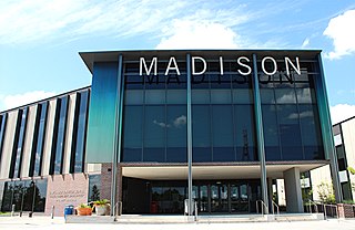
James Madison High School is a public high school located in the Hiram Clarke area of Houston, Texas, United States. The school, located in the Five Corners District, serves grades 9 through 12 and is part of the Houston Independent School District. The school is named after James Madison, the fourth President of the United States.
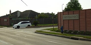
Corinthian Pointe is a large planned affordable subdivision located in Houston, Texas, in the United States. It is a part of the larger master planned community Pointe 2.3.4, and is within the 5 Corners District.
Independence Heights is a community in Houston, Texas, bordered by 40th Street east of N. Main and 40th Street west of N. Main to the north, Yale Street to the west, the 610 Loop to the south, and Airline Drive to the east. The Super Neighborhood boundary created by the City of Houston is bordered by Tidwell to the north, Shepherd Drive to the west, the 610 Loop to the south, and Interstate 45 to the east.

Greater Greenspoint, also referred to as the North Houston District, is a 7-square-mile (18 km2) business district and a suburban neighborhood in northern Harris County, Texas, United States, located mostly within the city limits of Houston. Centered around the junction of Interstate 45 and Texas State Highway Beltway 8 near George Bush Intercontinental Airport, the area is a classic example of a planned edge city. The initial 2,000-acre (8.1 km2) retail and office development centered around Greenspoint Mall was a project of the Friendswood Development Company during the 1970s and early 1980s.

Evan Edward Worthing Early College High School is a secondary school located in the Sunnyside area of Houston, Texas, United States.

Magnolia Park is an area of the East End, Houston, Texas, located near the Houston Ship Channel. One of the oldest Hispanic neighborhoods in the City of Houston, Magnolia Park was formerly incorporated as the City of Magnolia Park in eastern Harris County.

Four Seasons Hotel Houston is a hotel in Houston, Texas, United States. It is operated by Four Seasons Hotels and Resorts. The hotel includes Four Seasons Place, a group of 64 apartment units, and an Italian restaurant. It is a part of the Houston Center complex.
Willowbrook is an area in northwest Houston, Texas, United States, bordered by the Cutten Road to the east, Grant to the north, Rockland to the west, and Beltway 8 to the south. Sam Houston Race Park is one mile away.

City Park is a master-planned community in Houston, Texas, United States, that encompasses the subdivisions of City Park, City Park West, and City Oaks. It is within the Five Corners District and has 475 acres (192 ha) of space.

Brays Oaks, formerly known as Fondren Southwest, is an area in Southwest Houston, Texas, United States. The Brays Oaks Management District, also known as the Harris County Improvement District #5, governs the Brays Oaks area as well as other surrounding areas, such as Westbury. The City of Houston also defines the Brays Oaks Super Neighborhood, with separate boundaries.

The Montrose District was a management district located in Houston, Texas, United States. The land was governed by the Montrose Management District.

Houston House Apartments is a 31-story apartment complex in the Skyline District of Downtown Houston, Texas, United States.
Southcrest is a community in southeastern Houston, Texas. It is bordered by the 610 Loop, Martin Luther King Boulevard, Bellfort Boulevard, and Mykawa Road.

Westwood is a residential subdivision in Southwest Houston, Texas. The subdivision is bounded by the 610 Loop, the Union Pacific railroad tracks, Stella Link Road, and Willowbend Boulevard. It has about 800 houses.

Lakes of Parkway is a gated community in western Houston, Texas, also the most southern community in the Energy Corridor. It has 888 lots. Peggy O'Hare of the Houston Chronicle stated in 2002 that the houses were "upscale".
The site, at 12115 Main St.,[..]
