Wisdom is a small town in Beaverhead County, Montana, United States. The population was 98 at the 2010 census. The ZIP Code of the area is 59761. The town includes three tourist lodgings, service station, grocery, school (K-8), post office and a Forestry Service office. It is also included within the boundaries of the Wisdom, Montana, Census Designated Place, which is named after the town.

Bluff is a town in San Juan County, Utah, United States. The population was 320 at the 2000 census. Bluff incorporated in 2018.

Tahoe City is an unincorporated town in Placer County, California. Tahoe City is located on the shore of Lake Tahoe, at the outlet of the Truckee River.

Pioche is an unincorporated town in Lincoln County, Nevada, United States, approximately 180 miles (290 km) northeast of Las Vegas. U.S. Route 93 is the main route to Pioche and bypasses the town center just to the east, with Nevada State Route 321 and Nevada State Route 322 providing direct access. Its elevation is 6,060 feet (1,850 m) above sea level. Pioche is the county seat of Lincoln County. Pioche is named after François Louis Alfred Pioche, a San Francisco financier and land speculator originally from France. The town's population was 1,002 at the 2010 census.

Alamo is an unincorporated town in Lincoln County, Nevada, United States, about 90 miles (140 km) north of Las Vegas along U.S. Route 93. Its elevation is 3,449 feet (1,051 m). As of the 2010 census it had a population of 1,080.
Beulah is an unincorporated community and U.S. Post Office in Pueblo County, Colorado, United States. The ZIP Code of the Beulah Post Office is 81023. Beulah lies along State Highway 78 about 21 miles southwest of Pueblo, in the foothills of the Wet Mountains.

Biddle is a village in southeastern Powder River County, Montana, United States, near the Little Powder River. It lies along Highway 59, south of the town of Broadus, the county seat of Powder River County. Its elevation is 3,337 feet (1,017 m). It offers basic services not only to the community, but those that are passing through as well: a mercantile store with gas pumps, lodging through the mercantile, a post office, a one-room school accommodating grades K-8, a volunteer fire department and a small church.
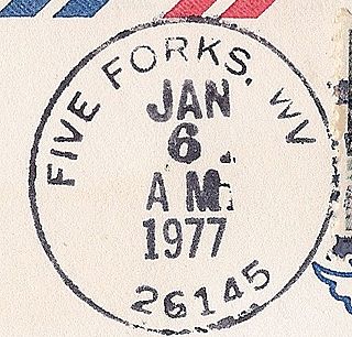
Five Forks is an unincorporated community in Calhoun County, West Virginia, United States. It lies along West Virginia Route 16 to the north of the town of Grantsville, the county seat of Calhoun County. Its elevation is 1,106 feet (337 m). The Five Forks Post Office is closed.

Creston is an unincorporated community in southeastern Wirt County, West Virginia, United States. It lies at the confluence of the Little Kanawha River and the West Fork Little Kanawha River on West Virginia Route 5, southeast of the town of Elizabeth, the county seat of Wirt County. Its elevation is 653 feet (199 m). Creston had a post office, which closed on June 25, 2011. The community was named for a drainage divide near the town site.

Melville is an unincorporated community in northern Sweet Grass County, Montana, United States. It lies along local roads just west of U.S. Route 191, north of the city of Big Timber, the county seat of Sweet Grass County. Its elevation is 5,020 feet (1,530 m). Although Melville is unincorporated, it has a post office, with the ZIP code of 59055, which opened on 4 January 1883.

Cohagen is an unincorporated community in southeastern Garfield County, Montana, United States. It lies along Highway 59 southeast of the town of Jordan, the county seat of Garfield County. Its elevation is 2,720 feet (829 m).
Brusett is an unincorporated community in northwestern Garfield County, Montana, United States. It lies along local roads west of the town of Jordan, the county seat of Garfield County. Its elevation is 2,904 feet (885 m). Although Brusett is unincorporated, it has a post office, with the ZIP code of 59318.

Sand Springs is an unincorporated rural hamlet in southwestern Garfield County, Montana, United States. It lies along the northern side of Highway 200, southwest of the town of Jordan, the county seat of Garfield County. Its elevation is 3,192 feet (973 m).
Sanders is an unincorporated community in northeastern Treasure County, Montana, United States, along the Yellowstone River. It lies along local roads east of the town of Hysham, the county seat of Treasure County, at an elevation of 2,602 feet (793 m). Sanders' post office first opened on March 30, 1904 and closed on October 14, 1905, only to be reopened on December 1, 1906. Although the post office finally closed on July 29, 1994, the community still has a separate ZIP code of 59076.
Myers is an unincorporated community in central Treasure County, Montana, United States, along the Yellowstone River. It lies along local roads west of the town of Hysham, the county seat of Treasure County. Its elevation is 2,680 feet (817 m). Myers' post office opened on October 31, 1911 and closed November 7, 1975.
Teigen is a former unincorporated community in western Petroleum County, Montana, United States, which stretched along Highway 200, approximately 20 miles west of the county seat, Winnett. Its elevation was 3,192 feet (973 m). Teigen's post office opened on November 24, 1914, and was closed on December 21, 1983,; the vicinity still has a separate ZIP code of 59084, which is serviced from Winnett Although Teigen still remains marked on many road atlases, including Google Maps, there are no longer any buildings left of the town; only a nearby home remains in proximity.
Olive is an unincorporated community in north central Powder River County, Montana, United States. It lies along Highway 59 northwest of the town of Broadus, the county seat of Powder River County. Its elevation is 3,232 feet (985 m). The post office has closed.
Otter is an unincorporated community in southwestern Powder River County, Montana, United States, in the Custer National Forest. It lies along local roads southwest of the town of Broadus, the county seat of Powder River County. Its elevation is 3,484 feet (1,062 m). Although Otter is unincorporated, it has a post office, with the ZIP code of 59062.

Petroleum County is a county in the U.S. state of Montana. As of the 2010 United States Census, the population was 494, making it the least populous county in Montana and the seventh-least populous in the United States. Its county seat is Winnett. The county's area was partitioned from Fergus County to become the last of Montana's 56 counties to be organized.
Cat Creek is an unincorporated community in eastern Petroleum County, Montana, United States.