Floods in Saint Petersburg

Last updated
A map of easily flooded areas of St. Petersburg from Brockhaus and Efron Encyclopedic Dictionary of 1907. Floods in Saint-Petersburg.jpg
A map of easily flooded areas of St. Petersburg from Brockhaus and Efron Encyclopedic Dictionary of 1907.

Floods in Saint Petersburg refer to a rise of water on the territory of St. Petersburg, a major city in Russia and its former capital. They are usually caused by the overflow of the delta of Neva River and surging water in the eastern part of Neva Bay but sometimes caused by melting snow. Floods are registered when the water rises above 160 cm with respect to a gauge at the Saint Petersburg Mining Institute. More than 300 floods have occurred since the city was founded in 1703. [1] [2] [3]

Contents

The construction of Saint Petersburg Dam, started in 1978 and completed in 2011, is expected to protect the city from devastating floods. [4] The dam is the last completed part of the Saint Petersburg Ring Road. Its first use to hold back the incoming Baltic water into Neva bay took place 28 November 2011 and had resulted in decrease of water rise to 1.3 MASL, that is below flood level equal to 1.6 masl, [5] which prevented the 309th flood in the history of the city and saved some 1.3 billion roubles of possible damage. [6]

Causes

Floods in St. Petersburg are caused by several factors. Cyclones, originating in the Baltic Sea with a prevalence of west winds, induce a "slow" matched Kelvin wave to rise and move towards the delta of Neva River where it meets the natural river flow moving in the opposite direction. The water level rises because of the shallowness of Neva Bay, flatness of its bottom and the narrowing of the Gulf of Finland near the delta. Seiches, onsets and another factors also contribute to the floods. Besides flooding as a result of storm surges, in 1903, 1921 and 1956 floods were caused by the melting of snow. [7]

History

A sign of the heaviest flood in St. Petersburg (1824) at the intersection of the Cadet line and the Bolshoi Prospekt of Vasilievsky Island Flood StPetersburg 1824.jpg
A sign of the heaviest flood in St. Petersburg (1824) at the intersection of the Cadet line and the Bolshoi Prospekt of Vasilievsky Island

Prior to the founding of St. Petersburg in 1703, the largest flood occurred in 1691. Swedish annals report that the water covered the entire area of the present St. Petersburg by 25 feet (7.6 meters). Knowing about frequent floods from the locals, the Swedes laid the fortress Nyenschantz and the city of Nyen away from the delta upstream of the Neva River, at the confluence of the river Ohta to Neva. [8]

The first flood in St. Petersburg city occurred 3 months after its founding, on the night of 19 to 20 August 1703. The water rose more than 2 meters. The water rose much higher on 20 September 1706, which in his letter to Alexander Menshikov, Peter I described as "the west-south-west wind brought the flood undescribed before. In my offices, it stood 21 inches above the floor, and people traveled by boats through the city streets. Yet it did not last long, less than 3 hours. And it was amusing to see people on the roofs and trees... Water was high, but didn't cause much harm ". [8] [9]

Engineering measures were instituted in the early 18th century, [10] and the central part of the city was flooded by only 130–150 cm. Floods are registered in St. Petersburg when water rises above 160 cm at the level gauge at the Saint Petersburg Mining Institute; floods up to 210 cm are considered dangerous, up to 299 cm very dangerous and above 300 cm catastrophic. Of the 324 floods in the history of St. Petersburg, three were catastrophic. [11]

Most floods occur in between September and December. Between 1703 and 2003, 324 floods were recorded with the height above 160 cm, of which 210 were higher than 210 cm. Some years have had several floods (five in 1752), and there are periods in which no flooding occurred (e.g. 1744–1752). [8]

Largest floods

19 November 1824, in front of Bolshoi Theatre 7 noiabria 1824 goda na ploshchadi u Bol'shogo teatra.jpg
19 November 1824, in front of Bolshoi Theatre
19 November 1824 The Flood in St.Petersburg in 1824. 1820-ies.jpg
19 November 1824
Sadovaya Street near the former Nikolsky Market, 15 November 1903 Floods in Saint Petersburg 1903 006.jpg
Sadovaya Street near the former Nikolsky Market, 15 November 1903
Bolshaya Podyacheskaya Street, 25 November 1903 Floods in Saint Petersburg 1903 005.jpg
Bolshaya Podyacheskaya Street, 25 November 1903
Boat transportation over Vasilievsky Island during the flood of 23 September 1924 Floods in Saint Petersburg 1924 001.jpg
Boat transportation over Vasilievsky Island during the flood of 23 September 1924
Vladimirsky Avenue after the flood of 1924 Floods in Saint Petersburg 1924 003.jpg
Vladimirsky Avenue after the flood of 1924
A pier during the flood of 18 October 1967 Floods in Saint Petersburg 1967 007.jpg
A pier during the flood of 18 October 1967
Near the Mining Institute on 18 October 1967 Floods in Saint Petersburg 1967 008.jpg
Near the Mining Institute on 18 October 1967

The following table lists the 50 largest floods since 1703. [8] [11] [12] The largest flood occurred in 1824 and killed several hundred people. This flood inspired the poem The Bronze Horseman by Alexander Pushkin. [10]

A recent large flood (239 cm) occurred on 8–9 January 2005 caused by the cyclone Erwin. [13] Six metro stations were closed. [8] There were three floods in 2008, all below 200 centimeters. [8] [14]

Chronological
No.
Date
(New style)
Water level
cm
Peak hour
1 84 19 November 1824 421 14:00
2 210 23 September 1924 380 19:15
3 71 9 September 1777 321 morning
4 244 15 October 1955 293 20:45
5 264 29 September 1975 281 4:00
6 39 22 October 1752 280 10:00
7 92 October 1723 272
8 141 November 1726 270
9 18313 November 1903 269 9:00
10 75 November 1721 265daytime
11 8620 August 1831 264 night
12 39 September 1706 262 daytime
13 319 30 November 1999 262 4:35
14 2510 September 1736 261
15 298 6 December 1986 260 13:30
16 215 15 October 1929 258 17:15
18 8324 January 1822 254 night
19 14429 October 1874 252 4:00
20 5520 November 1764 244
21 20117 November 1917 244 6:50
22 254 18 October 1967 244 13:30
23 4529 September 1756 242
24 13620 October 1873 242
25 1754 November 1897 242 12:00
26 261 17 November 1974 242 1:00
27 177 26 November 1898 240 23:30
28 260 20 December 1973 240 7:15
29 219 8 January 1932 239 3:00
30 225 8 October 1935 239 5:50
31 1812 October 1729 237 10:00
32 7629 September 1788 237
33 14526 November 1874 237 4:00
34 1712 November 1895 237 3:00
35 227 9 September 1937 236 5:30
36 3717 October 1744 234
37 4126 October 1752 234 12:00
38 4311 December 1752 234night
39 228 14 September 1938 233 2:25
40 269 7 September 1977 231 16:50
41 292 1 January 1984 231 21:20
42 12519 January 1866 229 10:00
43 208 24 November 1922 228 19:15
44 315 12 October 1994 228 13:50
45 1168 October 1863 227 2:00
46 211 3 January 1925 225 21:30
47 816 September 1802 224 daytime
48 12219 May 1865 224 9:10
49 202 24 August 1918 224 9:10
50 242 14 October 1954 222 21:00
320 9 January 2005 239

Protective dam

A giant lock of the Saint Petersburg Dam. Zatvor-c2.JPG
A giant lock of the Saint Petersburg Dam.

Construction of a complex of dams protecting St. Petersburg from the floods began in 1979 but was halted in the 1990s when 60% was completed. [11] The construction was resumed in 2005 and the completed dam was inaugurated on 12 August 2011. The dam is also the last completed part of the Saint Petersburg Ring Road, providing direct roadway access from mainland to the Kotlin Island and Kronshtadt.

The first use of the dam to hold back the incoming Baltic water into Neva bay took place 28 November 2011, when a major storm came from Scandinavia and caused a surge wave. Closing the dam had resulted in decrease of water rise to 1.3 masl, that is below flood level equal to 1.6 masl, [5] which prevented the flood and saved some 1.3 billion roubles of possible damage. [6] Though the 309th flood in the history of the city happened a month later at 27—28 December 2011, when despite closing the dam gates heavy cyclone forced the water to rise up to 1.7 masl which couldn't make serious damage to the city. [15] Specialists suppose that if there were no dam, there could have been level up to 2.3 masl with serious consequences. [16]

See also

Related Research Articles

<span class="mw-page-title-main">Gulf of Finland</span> Arm of the Baltic Sea

The Gulf of Finland is the easternmost arm of the Baltic Sea. It extends between Finland to the north and Estonia to the south, to Saint Petersburg in Russia to the east, where the river Neva drains into it. Other major cities around the gulf include Helsinki and Tallinn. The eastern parts of the Gulf of Finland belong to Russia, and some of Russia's most important oil harbors are located farthest in, near Saint Petersburg. As the seaway to Saint Petersburg, the Gulf of Finland has been and continues to be of considerable strategic importance to Russia. Some of the environmental problems affecting the Baltic Sea are at their most pronounced in the shallow gulf. Proposals for a tunnel through the gulf have been made.

<span class="mw-page-title-main">Neva</span> River in Russia

The Neva is a river in northwestern Russia flowing from Lake Ladoga through the western part of Leningrad Oblast to the Neva Bay of the Gulf of Finland. Despite its modest length of 74 kilometres (46 mi), it is the fourth-largest river in Europe in terms of average discharge.

<span class="mw-page-title-main">Karelian Isthmus</span> Isthmus in North-Western Russia

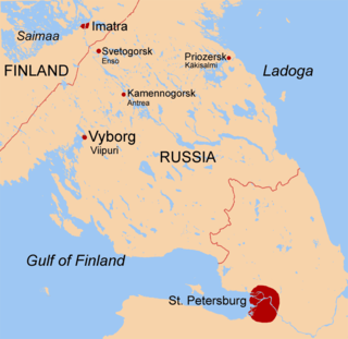
The Karelian Isthmus is the approximately 45–110-kilometre-wide (30–70 mi) stretch of land, situated between the Gulf of Finland and Lake Ladoga in northwestern Russia, to the north of the River Neva. Its northwestern boundary is a line from the Bay of Vyborg to the westernmost point of Lake Ladoga, Pekonlahti. If the Karelian Isthmus is defined as the entire territory of present-day Saint Petersburg and Leningrad Oblast to the north of the Neva and also a tiny part of the Republic of Karelia, the area of the isthmus is about 15,000 km2 (5,800 sq mi).

<span class="mw-page-title-main">Seiche</span> Standing wave in an enclosed or partially enclosed body of water

A seiche is a standing wave in an enclosed or partially enclosed body of water. Seiches and seiche-related phenomena have been observed on lakes, reservoirs, swimming pools, bays, harbors, caves and seas. The key requirement for formation of a seiche is that the body of water be at least partially bounded, allowing the formation of the standing wave.

<span class="mw-page-title-main">Storm surge</span> Rise of water associated with a low-pressure weather system

A storm surge, storm flood, tidal surge, or storm tide is a coastal flood or tsunami-like phenomenon of rising water commonly associated with low-pressure weather systems, such as cyclones. It is measured as the rise in water level above the normal tidal level, and does not include waves.

<span class="mw-page-title-main">Selenga</span> River in Mongolia and Russia

The Selenga or Selenge is a major river in Mongolia and Buryatia, Russia. Originating from its headwater tributaries, the Ider and the Delger mörön, it flows for 992–1,024 kilometres (616–636 mi) before draining into Lake Baikal. The Selenga therefore makes up the most distant headwaters of the Yenisey-Angara river system.

<span class="mw-page-title-main">Saint John River (Bay of Fundy)</span> River defining parts of the border of Maine and New Brunswick

The Saint John River is a 673-kilometre-long (418 mi) river that flows from Northern Maine into Canada, and runs south along the western side of New Brunswick, emptying into the Atlantic Ocean in the Bay of Fundy. Eastern Canada's longest river, its drainage basin is one of the largest on the east coast at about 55,000 square kilometres (21,000 sq mi).

<span class="mw-page-title-main">Kotlin Island</span> Russian island in the Gulf of Finland

Kotlin is a Russian island, located near the head of the Gulf of Finland, 32 kilometres (20 mi) west of Saint Petersburg in the Baltic Sea. Kotlin separates the Neva Bay from the rest of the gulf. The fortified city of Kronstadt is located on the island and forms part of a World Heritage Site that is Saint Petersburg and Related Groups of Monuments. The island serves as a gateway to Saint Petersburg and as such has been the site of several military engagements. The Kotlin programming language is named for the island, much as the Java programming language shares its name with an Indonesian island.

<span class="mw-page-title-main">Peter and Paul Fortress</span> Original citadel of St. Petersburg, Russia

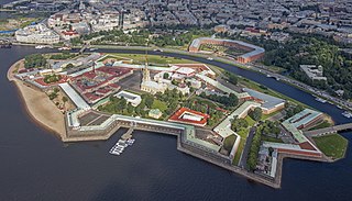
The Peter and Paul Fortress is the original citadel of St. Petersburg, Russia, founded by Peter the Great in 1703 and built to Domenico Trezzini's designs from 1706 to 1740 as a star fortress. Between the first half of the 1700s and early 1920s it served as a prison for political criminals. It has been a museum since 1924.

<span class="mw-page-title-main">Vasilyevsky Island</span> Island in St. Petersburg, Russia

Vasilyevsky Island is an island in St. Petersburg, Russia, bordered by the Bolshaya Neva and Malaya Neva Rivers in the south and northeast, and by Neva Bay of the Gulf of Finland in the west. Vasilyevsky Island is separated from Dekabristov Island by the Smolenka River. Together they form the territory of Vasileostrovsky District, an administrative division of Saint Petersburg.

<span class="mw-page-title-main">Levee breach</span> Situation where a levee containing water is breached

A levee breach or levee failure is a situation where a levee fails or is intentionally breached, causing the previously contained water to flood the land behind the levee.

<span class="mw-page-title-main">Saint Petersburg Dam</span> Flood control dam complex near Saint Petersburg, Russia

The Saint Petersburg Flood Prevention Facility Complex, unofficially the Saint Petersburg Dam, is a 25 km (16 mi) long complex of dams for flood control near Saint Petersburg, Russia. The dam extends from Lomonosov northward to Kotlin Island, then turns east toward Cape Lisiy Nos near Sestroretsk.

<span class="mw-page-title-main">Geography of Saint Petersburg</span>

Saint Petersburg is a city and a federal subject located in the Northwestern Federal District of Russia. It stands at the mouth of the Neva River at the east end of the Gulf of Finland.

<span class="mw-page-title-main">Economy of Saint Petersburg</span>

St. Petersburg is a major trade gateway, financial and industrial center of Russia specialising in oil and gas trade, shipbuilding yards, aerospace industry, radio and electronics, software and computers; machine building, heavy machinery and transport, including tanks and other military equipment, mining, instrument manufacture, ferrous and nonferrous metallurgy, chemicals, pharmaceuticals, medical equipment, publishing and printing, food and catering, wholesale and retail, textile and apparel industries, and many other businesses.

<span class="mw-page-title-main">Neva Bay</span>

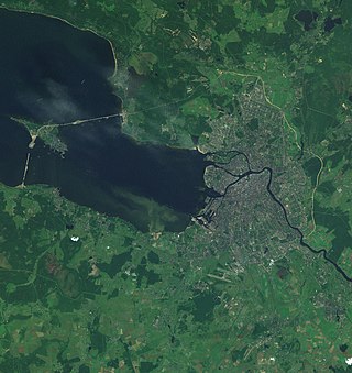
The Neva Bay, also known as the Gulf of Kronstadt, is the easternmost part of the Gulf of Finland between Kotlin Island and the Neva River estuary where Saint Petersburg city centre is located. It has a surface area of 329 km2 (127 sq mi). The entire bay has been separated from the Gulf of Finland by the 25 km long Saint Petersburg Dam. The area of water separated by the dam is 380 km2 (150 sq mi). The entire coastline is designated part of St. Petersburg rather than of Leningrad Oblast.

<span class="mw-page-title-main">Great Port of Saint Petersburg</span> Industrial port in Saint Petersburg, Russia

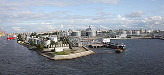
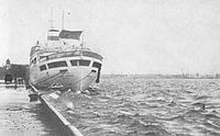
The Great Port of St. Petersburg or Port of St. Petersburg is a major seaport serving the city of St. Petersburg in northwest Russia. The port's water area is 164.6 km2. The mooring line is 31 km long and the water is 25 metres (82 ft) deep at the port's deepest anchorages. Since 2011, the port has been under the authority of a state-owned enterprise, the Port Authority of the Great Port of St. Petersburg. This agency oversees commercial navigation in the seaport of St. Petersburg and beyond in the designated areas of responsibility of the Russian Federation.

<span class="mw-page-title-main">Saint Petersburg</span> Federal city in Russia

Saint Petersburg, formerly known as Petrograd (1914–1924) and later Leningrad (1924–1991), is the second-largest city in Russia. It is situated on the Neva River, at the head of the Gulf of Finland on the Baltic Sea. The city had a population of roughly 5.6 million residents as of 2021. Saint Petersburg is the fourth-most populous city in Europe, the most populous city on the Baltic Sea, and the world's northernmost city of more than 1 million residents. As Russia's Imperial capital, and a historically strategic port, it is governed as a federal city.

<span class="mw-page-title-main">Navigation Pass S-1 of Saint Petersburg Dam</span>

The Navigation Pass S-1 of Saint Petersburg Dam is a storm surge barrier in the eastern part of the Finnish Gulf to the south of the island of Kotlin, Russia. It is part of a waterway from the Baltic Sea to Saint Petersburg located at eastern end of Neva Bay. The scheme of S-1 is similar to the Maeslantkering barrier in the Netherlands and consists of two submersible caissons with dimensions 125×22 metres, which are used to close the navigable channel and thus stop storm tides from proliferating into Neva Bay. The channel is 200 metres wide and 16 metres deep. The Saint Petersburg Ring Road crosses it via an underwater tunnel.

<span class="mw-page-title-main">Land loss</span>

Land loss is the term typically used to refer to the conversion of coastal land to open water by natural processes and human activities. The term land loss includes coastal erosion. It is a much broader term than coastal erosion because land loss also includes land converted to open water around the edges of estuaries and interior bays and lakes and by subsidence of coastal plain wetlands. The most important causes of land loss in coastal plains are erosion, inadequate sediment supply to beaches and wetlands, subsidence, and global sea level rise. The mixture of processes responsible for most of the land loss will vary according to the specific part of a coastal plain being examined. The definition of land loss does not include the loss of coastal lands to agricultural use, urbanization, or other development.

<span class="mw-page-title-main">Outline of Saint Petersburg</span> Overview of and topical guide to Saint Petersburg

Saint Petersburg – second-largest city in Russia. An important Russian port on the Baltic Sea, it has the status of a federal subject. Its name was changed to "Petrograd" in 1914, then to "Leningrad" in 1924, and back to Saint Petersburg in 1991.

References

  1. Holly Hughes, Larry West (2008). Frommer's 500 Places to See Before They Disappear. Frommer's. p. 327. ISBN   0-470-18986-X.
  2. D. V. Ryabchuk; et al. The Neva Bay (Russia) – antropogenic lagoon (PDF). All-Russia Research Geological Institute.
  3. Water pollution in the hydroelectric power plants area [ permanent dead link ]
  4. [Saint Petersburg Dam official site (in Russian)
  5. 1 2 (in Russian) Мощнейший ураган и наводнение накрыли Петербург: вода угрожает городу (ВИДЕО), Главред, 11/28/2011
  6. 1 2 Дирекция КЗС: Дамба предотвратила ущерб в 1,3 млрд рублей (in Russian)
  7. A. Morozova (26 February 2010). "A bridge might be removed in St. Petersburg because of the flood". Komsomolskaya Pravda.
  8. 1 2 3 4 5 6 List of floods in St. Petersburg (in Russian)
  9. K. Valishevsky (2002). Петр Великий (in Russian). ACT. p. 294. ISBN   5-17-015738-X.
  10. 1 2 Julie A. Buckler (2005). Mapping St. Petersburg: imperial text and cityshape. Princeton University Press. pp. 230–233. ISBN   0-691-11349-1.
  11. 1 2 3 The actual situation of problem in the Partner Countries [ permanent dead link ], NATO Science Programme
  12. R. Nezhihovsky (1981). Neva River and Neva Bay. Gidrometeoizdat. pp. 203–204.
  13. Averkiev, Alexander S.; Klevannyy, Konstantin A. (2010). "A case study of the impact of cyclonic trajectories on sea-level extremes in the Gulf of Finland". Continental Shelf Research. 30 (6): 707. doi:10.1016/j.csr.2009.10.010.
  14. Storm winds in St. Petersburg – St. Petersburg news, Фонтанка.Ру (in Russian)
  15. "Петербург не избежал наводнения, но серьезных последствий нет". RIA Novosti (in Russian). 2011-12-28.
  16. 309-е наводнение войдет в историю Петербурга как «историческая формальность». Karpovka.net (in Russian). 2011-12-28.