Florence, Alabama

Last updated

Florence, Alabama
Downtown Florence Historic District cropped.jpg
Downtown Florence Historic District
Flag of Florence, Alabama.png
Seal of Florence, Alabama.png
Nickname: 
"Alabama's Renaissance City"
Lauderdale County Alabama Incorporated and Unincorporated areas Florence Highlighted 0126896.svg
Location of Florence in Lauderdale County, Alabama.
Coordinates: 34°49′13″N87°39′46″W / 34.82028°N 87.66278°W / 34.82028; -87.66278
CountryUnited States
State Alabama
County Lauderdale
IncorporatedJanuary 7, 1826 [1]
Named for Florence, Tuscany, Italy
Government
  TypeMayor/Council (Since 1984)
  MayorAndrew Betterton
Area
[2]
   City 26.73 sq mi (69.23 km2)
  Land26.52 sq mi (68.68 km2)
  Water0.21 sq mi (0.55 km2)
Elevation
[3]
607 ft (185 m)
Population
 (2020)
   City 40,184
  Density1,515.35/sq mi (585.08/km2)
   Metro
147,317 (US: 281st)
Time zone UTC-6 (Central (CST))
  Summer (DST) UTC-5 (CDT)
ZIP codes
35630-35634
Area codes 256, 938
FIPS code 01-26896
GNIS feature ID2403619 [3]
Website www.florenceal.org

Florence is a city in, and the county seat of, Lauderdale County, Alabama, United States, in the state's northwestern corner, and had a population of 40,184 in the 2020 census. Florence is located along the Tennessee River and is home to the University of North Alabama, the oldest public college in the state, which makes Florence a college town. Florence is located about 70 miles west of Huntsville, Alabama, via US-72.

Contents

Florence is the largest and principal city of the Quad Cities commonly known as "The Shoals" (which also includes the cities of Muscle Shoals, Sheffield, and Tuscumbia in Colbert County). [4] [5] “The Shoals” had a population of 148,779 in the 2020 census. Florence is considered northwestern Alabama's primary economic hub. Florence is the most populous city of 30 places in the United States with the name Florence, which was slightly larger than Florence, South Carolina.

Annual tourism events include the W. C. Handy Music Festival in the summer and the Renaissance Faire in the fall. Landmarks in Florence include the 20th-century Rosenbaum House, the only Frank Lloyd Wright-designed home located in Alabama. The Florence Indian Mound, constructed by indigenous people between 400 BCE and 100 BCE in the Woodland period, is the largest surviving earthen mound in the state and is 43 feet high. It is listed on the National Register of Historic Places. It has been protected by the city since 1945. In 2017 a new, expanded museum was built to replace one built in 1968 that displays artifacts and interprets the ancient and historic cultures of all the indigenous peoples in the area. [6]

Geography

According to the U.S. Census Bureau, Florence has a total area of 25.0 square miles (65 km2), of which 24.9 square miles (64 km2) is land, and 0.1 square miles (0.26 km2) (0.40%) is water.

Florence is located on Wilson Lake and Pickwick Lake, bodies of water on the Tennessee River dammed by Pickwick Dam and Wilson Dams. Pickwick Lake was created by the Tennessee Valley Authority (TVA), an agency established under President Franklin Delano Roosevelt's New Deal. It was a public works program intended to build dams and hydroelectric power and related infrastructure to generate electricity for the rural region to stimulate economic development, provide flood control, and recreational opportunities. Wilson Dam (now operated by the TVA) was authorized by President Woodrow Wilson in 1918 and was the first dam constructed on the Tennessee River.[ citation needed ]

Climate

The climate in this area is characterized by hot, humid summers and generally mild to cool winters. According to the Köppen Climate Classification system, Florence has a humid subtropical climate, abbreviated "Cfa" on climate maps. [7]

The average temperature of Florence is 59 °F (15 °C). The average yearly precipitation in Florence is 57.06 in (144.9 cm). [7] On average, Florence gets 2.25 in (5.7 cm) of snow per year, which is above the average for Alabama of 0.57 in (1.4 cm). [8]

While Florence is almost 300 mi (480 km) from the Gulf of Mexico, strong hurricanes have brought severe weather to the area. For example, in 2005, the path of Hurricane Katrina came very close to the city, causing nearly 70 mph (110 km/h) winds and some storm damage.

Climate data for Florence, 1991–2020 simulated normals (558 ft elevation)
MonthJanFebMarAprMayJunJulAugSepOctNovDecYear
Mean daily maximum °F (°C)50.5
(10.3)
55.0
(12.8)
63.7
(17.6)
72.7
(22.6)
80.1
(26.7)
87.1
(30.6)
89.8
(32.1)
89.4
(31.9)
84.6
(29.2)
74.3
(23.5)
62.4
(16.9)
53.4
(11.9)
71.9
(22.2)
Daily mean °F (°C)40.6
(4.8)
44.2
(6.8)
52.2
(11.2)
60.6
(15.9)
69.1
(20.6)
76.5
(24.7)
79.5
(26.4)
78.6
(25.9)
73.0
(22.8)
61.9
(16.6)
50.5
(10.3)
43.5
(6.4)
60.9
(16.0)
Mean daily minimum °F (°C)30.7
(−0.7)
33.6
(0.9)
40.5
(4.7)
48.7
(9.3)
58.1
(14.5)
65.8
(18.8)
69.3
(20.7)
68.0
(20.0)
61.3
(16.3)
49.3
(9.6)
38.7
(3.7)
33.4
(0.8)
49.8
(9.9)
Average precipitation inches (mm)5.30
(134.60)
5.28
(134.01)
5.44
(138.15)
5.20
(132.00)
4.92
(124.98)
4.84
(122.88)
4.96
(125.97)
4.22
(107.26)
4.08
(103.70)
3.63
(92.17)
4.12
(104.57)
6.07
(154.24)
58.06
(1,474.53)
Average dew point °F (°C)32.2
(0.1)
34.7
(1.5)
40.5
(4.7)
48.7
(9.3)
58.5
(14.7)
66.4
(19.1)
70.0
(21.1)
68.7
(20.4)
62.8
(17.1)
51.8
(11.0)
41.0
(5.0)
35.8
(2.1)
50.9
(10.5)
Source: PRISM Climate Group [9]

History

Beginnings

Evidence for human habitation in the Florence area goes back to at least 500 BCE, when the Florence Indian Mound, the largest of its type in the Tennessee Valley, was constructed as an earthwork during the Woodland period. [10] Successive cultures arose after this. In the historic period, the area of present-day Florence was occupied by the Chickasaw Nation. They first encountered white traders and settlers beginning in the late 1700s, and were forced to cede their land to the Federal government through a series of treaties in early 1800s, as part of the Indian Removal policy to extinguish tribal land claims east of the Mississippi River. The Chickasaw were removed to west of the river in Indian Territory (now Oklahoma). [11]

General John Coffee, John McKinley, a future U.S. Supreme Court Justice, and five other trustees established the Cypress Land Company to found a town on a hill overlooking the Tennessee River. [12] The company bought the land, believing that Florence's location along Jackson's Military Road and at the end of the treacherous Muscle Shoals rapids on the Tennessee River would enable it to develop as a major commercial center. [13] [14] In 1819, Coffee commissioned Ferdinand Sannoner, a young Italian engineer, to survey and plan the town. [11] Situating the town on the plateau overlooking the Tennessee River provided protection from flooding as well as the disease of the swampier lowlands by the riverbank. The investors were so pleased with Sannoner's work that he was allowed to choose the name of the new settlement; he named it after Florence, the capital of the Tuscany region of Italy. [12]

Antebellum Florence (1826–1860)

The first river steamboat visited the town in 1821. [15] Speculators and settlers, including General Andrew Jackson and President James Monroe, bought up plots of land as they were sold by the Cypress Land Co. [12] Florence quickly became an important commercial hub on the Tennessee River, but it did not reach the level its founders had hoped. [14] However, Florence did grow quickly enough to be incorporated by the State Legislature in 1826. [16] By 1831, the increased cotton cultivation in the area to the east of Florence necessitated the expansion and improvement of transport facilities in the area, including the digging of a canal around the Muscle Shoals. [17] Congress appropriated land for that purpose and construction began in 1831, with the Muscle Shoals Canal opening in 1837, however, the locks could not support steamships and the state had difficulty maintaining the construction, so it was abandoned shortly thereafter. [18] Equally important was the construction of a railroad bridge across the Tennessee River, with the first bridge being completed in the 1830s, but would be washed away by a flood soon after completion. [19] Another bridge would be completed in 1840 and would last until the mid-1850s, when it was damaged by tornadoes in 1850 and 1854, resulting in its decommissioning. The rock piers of the 1840 bridge survived the damage and form the foundation of the present structure. [19] As a part of Florence's development as a commercial hub, a variety of manufacturing enterprises sprung up around the city, including an iron foundry, lumber, cotton, and wool mills, as well as a complex of cotton, flour, and corn mills along Cypress Creek known as the Globe Factory. [20]

Plantations, too, sprung up around Florence, driven by cheap fertile land and high cotton prices. Two of these plantation homes are of note: Sweetwater Mansion and the Forks of Cypress. Sweetwater Mansion is notable for being the residence of Robert M. Patton, the first governor of Alabama after the Civil War and for the various paranormal sightings that have occurred there. [21] The Forks of Cypress, on the other hand, was the plantation home of James Jackson, one of the original Cypress Land Co. trustees, and was acclaimed for its architectural style and the quality of its racing horses. [22] With the plantation economy, so too came slavery. While slavery in northwest Alabama did not reach the magnitude that it did in the Black Belt, a significant percentage of the population (about 14% in 1818) was enslaved and by 1860, there were twenty three plantations in Lauderdale County that had over fifty slaves. [23] Not all slaves worked on the plantation, however, many worked in construction or in other contexts. Dred Scott was brought to Florence in the 1820s and served as a hosteler in the local inn, before his participation in the landmark Supreme Court case. [24]

Adolph Metzner drawing of the "female college" in Florence Florence Alabama female college, June 1862 LCCN2017646931.jpg
Adolph Metzner drawing of the "female college" in Florence

As a sign of progress and ambition, townspeople established the Florence Female Academy here in 1847, for paying female students. By the 1850s, the school was converted into the Florence Synodical Female College, affiliated with the Presbyterian Church. It closed in 1893. A historical marker commemorates the site. [25] LaGrange College, Alabama's first chartered college, was established near Leighton in 1830 before being moved across the river to Florence in 1855. The move to Florence was controversial, however, and the Florence site was denied the use of the LaGrange name and was thus chartered as Florence Wesleyan University in 1856, with its main building being Wesleyan Hall. One hundred and 60 students enrolled in the first year of operation (1855) of Florence Wesleyan University and quickly attracted students from five states and two foreign countries. [26] The university also chartered a grammar school, which still serves today as Kilby Laboratory School, the only university-operated elementary school in Alabama. After becoming publicly owned during the Postbellum period, the university went through a variety of name changes, including: Florence Normal School, Florence State Teachers College, and Florence State University, before changing its name to the University of North Alabama in 1972.

Civil War through the turn of the century (1861–1900)

The 20th-century

The Burrell Normal School was open from 1903 until 1969, and served as a private segregated school for African American students in Florence, serving grades 1-12 and a normal school. [27] [28]

Demographics

Historical population
CensusPop.Note
1850 802
1860 1,39573.9%
1870 2,00343.6%
1880 1,359−32.2%
1890 6,012342.4%
1900 6,4787.8%
1910 6,6893.3%
1920 10,52957.4%
1930 11,72911.4%
1940 15,04328.3%
1950 23,87958.7%
1960 31,64932.5%
1970 34,0317.5%
1980 37,0298.8%
1990 36,426−1.6%
2000 36,264−0.4%
2010 39,3198.4%
2020 40,1842.2%
U.S. Decennial Census [29]
2018 Estimate [30]

2020

Florence Racial Composition [31]
RaceNum.Perc.
White 28,00669.69%
Black or African American 7,50318.67%
Native American 1220.3%
Asian 5191.29%
Pacific Islander 220.05%
Other/Mixed 1,9164.77%
Hispanic or Latino 2,0965.22%

As of the 2020 United States Census, there were 40,184 people, 17,475 households, and 9,718 families residing in the city.

2010

According to the 2010 census:

2000

As of the census of 2000, there were 36,264 people, 15,820 households, and 9,555 families residing in the city. The population density was 1,454.6 inhabitants per square mile (561.6/km2). There were 17,707 housing units at an average density of 710.2 per square mile (274.2/km2). The racial makeup of the city was 78.39% White, 19.20% Black or African American, 0.24% Native American, 0.62% Asian, 0.03% Pacific Islander, 0.54% from other races, and 0.97% from two or more races. 1.34% of the population were Hispanic or Latino of any race.

There were 15,820 households, out of which 25.9% had children under the age of 18 living with them: 43.6% were married couples living together, 14.0% had a female householder with no husband present, and 39.6% were non-families. Nearly 33.8% of all households were made up of individuals, and 13.3% had someone living alone who was 65 years of age or older. The average household size was 2.20, and the average family size was 2.82.

In the city, the population was spread out, with 21.4% under the age of 18, 13.7% from 18 to 24, 25.7% from 25 to 44, 21.7% from 45 to 64, and 17.5% who were 65 years of age or older. The median age was 37 years. For every 100 females, there were 84.0 males. For every 100 females age 18 and over, there were 79.7 males.

The median income for a household in the city was $28,330, and the median income for a family was $40,577. Males had a median income of $34,398 versus $21,385 for females. The per capita income for the city was $19,464. About 14.4% of families and 20.4% of the population were below the poverty line, including 25.9% of those under age 18 and 13.3% of those age 65 or over.

Education

Harrison Plaza, University of North Alabama UNA HarrisonPlaza.jpg
Harrison Plaza, University of North Alabama

Situated in Florence, and founded in 1830 as LaGrange College, and later operating as a normal school, the University of North Alabama, a public, co-educational, higher education institution, is Alabama's oldest state-certified university. [32]

Florence City Schools is the organization of the K–12 public school system. Florence High School (grades 10–12) is the main high school, with an enrollment of approximately 1,000 students. It was created by a merger between the previous two city high schools, Bradshaw High School and Coffee High School. Florence High is located at the former Bradshaw site in the eastern part of the city. The merger also led to the creation of Florence Middle School (grades 7–8) and the Florence Freshman Center (grade 9). The middle school is located at the former Coffee High campus, east of downtown, and the Florence Freshman Center is located at the Florence High School campus.

There are five private schools in Florence: Riverhill School for K-6, St. Joseph Regional Catholic School for grades K–8, and Mars Hill Bible School, Shoals Christian School, and Florence Christian Academy. Each of the latter are multi-denominational, K–12 schools.

Government

The city has a mayor-council form of government. Each of the council members is elected from one of six single-member districts. The mayor is elected at-large.

Mayor

Andrew Betterton was elected as the mayor of Florence on October 6, 2020. He defeated incumbent Mayor Steve Holt by 11 votes.

City Council

Culture and events

The City of Florence is home to several museums, historical sites and numerous parks that serve the cultural and recreational needs of citizens and tourists. A variety of festivals are held throughout the year.

Museums

Festivals

The festivals are listed chronologically.

Other attractions

Recreation

Parks

Aerial view of Florence FlorenceAlabamaFrom9kFeet.jpg
Aerial view of Florence

Other recreation

Transportation

O'Neal Bridge over the Tennessee River Florence, Alabama O'Neal Bridge by Noah McDonald.jpg
O'Neal Bridge over the Tennessee River

Florence is the merger point for two major U.S. Highways, as well as several Alabama Highways. Both U.S. Highway 43 and U.S. Highway 72 merge just east of the city limits in Killen, and are co-signed their entire length through the city. Highway 43, running north and south, helps connect the city to Lawrenceburg and Columbia to the north in Tennessee, as well as Tuscaloosa and Mobile to the south. Highway 72 helps connect the city to Huntsville and Chattanooga, Tennessee to the east and Memphis, Tennessee to the west. Interstate 65 is accessible about forty-five minutes east on Highway 72. Both of these roads cross the Tennessee River on O'Neal Bridge, connecting Florence to Sheffield.

Alabama state highways that serve the city include State Route 13, State Route 17, State Route 20, State Route 133, and State Route 157. Alabama 133 connected Florence and Muscle Shoals via Wilson Dam until 2002, when the new six-lane "Patton Island Bridge" finished construction. The bridge is part of a new corridor that will eventually [ citation needed ] see the widening of Wilson Dam Road in Muscle Shoals to Alabama 20, and the construction of a new road from the bridge to Florence Blvd. in Florence. State Route 157, a road to Florence and the Shoals area, serves as a four-lane link to Interstate 65 in Cullman. The project was completed in the summer of 2007. The road is known as the "University of North Alabama Highway".

Florence and the Shoals area does not have a direct link to an Interstate highway. One solution discussed has been the Memphis to Atlanta Highway, proposed to connect the two cities via a freeway through north Alabama. However, in recent years Mississippi has concentrated its funding on U.S. 78 (Interstate 22), also known as "Corridor X". Though U.S. 72 through Mississippi is four lanes, there are no plans to upgrade it to freeway status. The state of Georgia has also not committed to the necessary work to connect the freeway from the Alabama state line to Atlanta. The highway remains in the planning stages with the Alabama Department of Transportation.[ citation needed ]

Another plan recently discussed is extending Interstate 565 west from its current terminus just outside Decatur, along Alabama 20/Alternate U.S. 72. The plan has received support from Decatur officials. [ citation needed ]

Florence is served by the Northwest Alabama Regional Airport in Muscle Shoals. The airport is used for commercial and general aviation, It is served commercially by Contour Airlines which provides several daily flights to Charlotte Douglas International Airport, an American Airlines hub, giving the city access to hundreds of domestic and international destinations. Huntsville International Airport, another option for Florence residents, offers service to eleven domestic destinations, and is an hour's drive from Florence.

Local industry is served by the Tennessee Southern Railroad (TSRR), which runs from Florence to Columbia, Tennessee, and the Port of Florence on Pickwick Lake.

Media

Numerous radio, television and low-power FM radio stations and translators serve Florence and the greater area, all of which are in the greater Florence MSA. Among them are:

AM radio

FM radio

Television

Past television stations
Cable providers
Florence is served by Comcast and AT&T. Their services include television, internet, home phone, and home security services. Comcast has been a provider of television and other services in the Florence area since the early 1960s. AT&T has provided services to Florence since the early 2000s, when they acquired Bell South. Florence is also served by major satellite television providers, including DirecTV and Dish Network.

Notable people

Related Research Articles

<span class="mw-page-title-main">Colbert County, Alabama</span> County in Alabama, United States

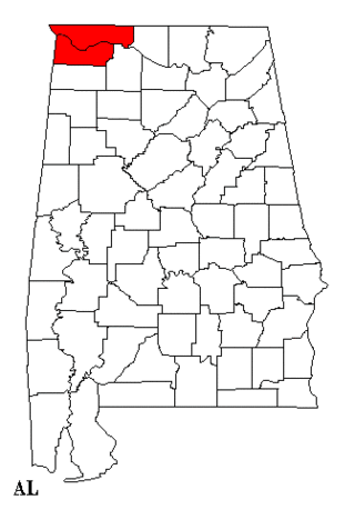
Colbert County is a county located in the northwestern part of the U.S. state of Alabama. As of the 2020 census the county's population was 57,227. The county seat is Tuscumbia. The largest city is Muscle Shoals.

<span class="mw-page-title-main">Lauderdale County, Alabama</span> County in Alabama, United States

Lauderdale County is a county located in the northwestern corner of the U.S. state of Alabama. At the 2020 census the population was 93,564. Its county seat is Florence. Its name is in honor of Colonel James Lauderdale, of Tennessee. Lauderdale is part of the Florence-Muscle Shoals, AL Metropolitan Statistical Area, also known as "The Shoals".

<span class="mw-page-title-main">Cherokee, Alabama</span> Town in Alabama, United States

Cherokee is a town in west Colbert County, Alabama, United States. Located near the Tennessee River, it is part of the Florence–Muscle Shoals metropolitan area, known as "The Shoals". As of the 2010 census, the population of the town was 1,048.

<span class="mw-page-title-main">Muscle Shoals, Alabama</span> City in the United States

Muscle Shoals is the largest city in Colbert County, Alabama, United States. It is located on the left bank of the Tennessee River in the northern part of the state and, as of the 2010 census, its population was 13,146. The estimated population in 2019 was 14,575.

<span class="mw-page-title-main">Waterloo, Alabama</span> Town in Alabama, United States

Waterloo is a town in Lauderdale County, Alabama, United States. It is part of the Florence–Muscle Shoals metropolitan area, known as "The Shoals". As of the 2010 census, the population of the town was 203, down from 208 in 2000. The town and surrounding area is served by Waterloo High School and by the Waterloo Volunteer Fire Department.

<span class="mw-page-title-main">Tennessee River</span> River in the southeastern United States

The Tennessee River is the largest tributary of the Ohio River. It is approximately 652 miles (1,049 km) long and is located in the southeastern United States in the Tennessee Valley. The river was once popularly known as the Cherokee River, among other names, as the Cherokee people had their homelands along its banks, especially in what are now East Tennessee and northern Alabama. Additionally, its tributary, the Little Tennessee River, flows into it from Western North Carolina and northeastern Georgia, where the river also was bordered by numerous Cherokee towns. Its current name is derived from the Cherokee town, Tanasi, which was located on the Tennessee side of the Appalachian Mountains.

<span class="mw-page-title-main">Tennessee Valley</span> Drainage basin of the Tennessee River

The Tennessee Valley is the drainage basin of the Tennessee River and is largely within the U.S. state of Tennessee. It stretches from southwest Kentucky to north Alabama and from northeast Mississippi to the mountains of Virginia and North Carolina. The border of the valley is known as the Tennessee Valley Divide. The Tennessee Valley contributes greatly to the formation of Tennessee's three legally recognized sectors.

<span class="mw-page-title-main">North Alabama</span> Region in Alabama

North Alabama is a region of the U.S. state of Alabama. Several geographic definitions for the area exist, with all descriptions including the nine counties of Alabama's Tennessee Valley region. The North Alabama Industrial Development Association also lists Cherokee, Cullman, Franklin, and Winston counties in the region. The Alabama Mountain Lakes Tourist Association expands the definition further to include Blount, Etowah, and Marion counties.

<span class="mw-page-title-main">Wheeler Dam</span> Dam in Alabama, United States

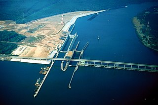
Wheeler Dam is a hydroelectric dam on the Tennessee River between Lauderdale County and Lawrence County in Alabama. It is one of nine dams on the river owned and operated by the Tennessee Valley Authority, which built the dam in the mid-1930s as part of a New Deal-era initiative to improve navigation on the river and bring flood control and economic development to the region. The dam impounds the Wheeler Lake of 67,070 acres (27,140 ha) and its tailwaters feed into Wilson Lake.

<span class="mw-page-title-main">Florence–Muscle Shoals metropolitan area</span> Metro area in northwest Alabama

The Florence-Muscle Shoals Metropolitan Area, commonly known as “The Shoals”, is a metropolitan statistical area in northwestern Alabama including the cities of Florence, Muscle Shoals, Tuscumbia, and Sheffield, and the counties of Lauderdale and Colbert. The 2020 Census population for the Shoals is 148,779 and an additional 410,000 commute to the Shoals daily as the economic, social, and educational center of northwest Alabama. The Shoals has also been known as the Tri-Cities and the Quad-Cities by locals.

<span class="mw-page-title-main">Pickwick Landing Dam</span> Dam in Tennessee, United States

Pickwick Landing Dam is a hydroelectric dam on the Tennessee River in Hardin County, in the U.S. state of Tennessee. The dam is one of nine dams on the river owned and operated by the Tennessee Valley Authority, which built the dam in the 1930s as part of a New Deal-era initiative to create a continuous navigation channel between the river's mouth and Knoxville, and bring economic development to the area. The dam impounds the 43,100-acre (17,400 ha) Pickwick Lake and its tailwaters are part of Kentucky Lake.

<span class="mw-page-title-main">Pickwick Lake</span> Man-made reservoir in the southeastern United States

Pickwick Lake is the reservoir created by Pickwick Landing Dam as part of the Tennessee Valley Authority. The lake stretches from Pickwick Landing Dam in Counce, Tennessee, to Wilson Dam in Florence, Alabama, and is one of the few lakes in the United States to be located in 3 different states.

<span class="mw-page-title-main">Wilson Dam</span> Dam on the Tennessee River, Alabama

Wilson Dam is a dam on the Tennessee River between Lauderdale and Colbert counties in Alabama. Completed in 1924 by the United States Army Corps of Engineers, it impounds Wilson Lake, and is one of nine Tennessee Valley Authority (TVA) dams on the Tennessee River. It was declared a National Historic Landmark on November 13, 1966, for its role as the first dam to come under the TVA's administration. The dam is named for Woodrow Wilson.

<span class="mw-page-title-main">Alabama State Route 20</span> State highway in Alabama, United States

State Route 20 (SR 20) is a 73.978-mile-long (119.056 km) state highway in the northern part of the U.S. state of Alabama. It travels from the Tennessee state line, where it continues as Tennessee State Route 69, northwest of Florence, east to Interstate 65 (I-65), east of Decatur. It crosses the Tennessee River at Florence and also at Decatur

<span class="mw-page-title-main">Muscle Shoals Sound Studio</span> Recording studio in Sheffield, Alabama

Muscle Shoals Sound Studio is an American recording studio in Sheffield, Alabama, formed in 1969 by four session musicians known as The Muscle Shoals Rhythm Section. They had left nearby FAME Studios in Muscle Shoals to create their own recording facility.

<span class="mw-page-title-main">Alabama State Route 17</span> State highway in Alabama, United States

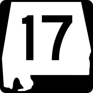
State Route 17 is a major north-to-south highway within the U.S. state of Alabama. Covering 346.562 miles (557.737 km), it travels the length of the state between US 90 in Mobile and SR 13 at the Tennessee state line, north of Zip City.

<span class="mw-page-title-main">The Forks of Cypress</span> United States historic place

The Forks of Cypress was a large slave-labour cotton farm and Greek Revival plantation house near Florence in Lauderdale County, Alabama, United States. It was designed by architect William Nichols for James Jackson and his wife, Sally Moore Jackson. Construction was completed in 1830. It was the only Greek Revival house in Alabama with a two-story colonnade around the entire house, composed of 24 Ionic columns. The name was derived from the fact that Big Cypress Creek and Little Cypress Creek border the plantation and converge near the site of the main house. Although the main house was destroyed by fire in 1966 after being struck by lightning, the site was placed on the Alabama Register of Landmarks and Heritage on April 14, 1992 and the National Register of Historic Places on October 10, 1997. The site is the property of the State of Alabama; a local board has oversight.

<span class="mw-page-title-main">Alabama State Route 133</span> State highway in Alabama, United States

State Route 133 (SR 133) is a 16.976-mile-long (27.320 km) mostly multi-lane state highway and is a primary artery through the Florence–Muscle Shoals metropolitan area in the northwestern part of the U.S. state of Alabama.

Muscle Shoals National Heritage Area is a federally designated National Heritage Area in the northwestern portion of the U.S. state of Alabama. It is centered on the portion of the Tennessee River around Muscle Shoals and interprets the region's history and culture.

<span class="mw-page-title-main">Riverton Lock</span> Entrance to Colbert shoals canel

Riverton Lock, also known as the Colbert Shoals Lock, was the entrance to Colbert Shoals Canal, a low water alternative route around Colbert and Bee Tree Shoals on the Tennessee River.

References

  1. Act 95. "AN ACT to incorporate the town of Florence in the state of Alabama." Archived May 5, 2021, at the Wayback Machine Acts Passed at the Seventh Annual Session of the General Assembly of the State of Alabama. 1825. Pages 70–73. Retrieved May 21, 2022.
  2. "2020 U.S. Gazetteer Files". United States Census Bureau. Retrieved October 29, 2021.
  3. 1 2 U.S. Geological Survey Geographic Names Information System: Florence, Alabama
  4. "Florence-Muscle Shoals MSA" . Retrieved March 11, 2020.
  5. Florence-Muscle Shoals map
  6. Barske, Carolyn M. (October 7, 2015). "Indian Mound and Museum". Encyclopedia of Alabama. Retrieved June 20, 2022.
  7. 1 2 "Florence, Alabama Köppen Climate Classification (Weatherbase)". Weatherbase.com. Retrieved July 30, 2018.
  8. "Florence, AL Weather". USA.com. Retrieved July 30, 2018.
  9. "PRISM Climate Group at Oregon State University". Northwest Alliance for Computational Science & Engineering (NACSE), based at Oregon State University. Retrieved March 16, 2023.
  10. Pretes, Michael (2020). "Florence, AL and the Muscle Shoals Region". Southeastern Geographer. 60: 193–196. doi:10.1353/sgo.2020.0023. S2CID   226604262.
  11. 1 2 "Florence". Encyclopedia of Alabama. Retrieved January 17, 2021.
  12. 1 2 3 Knight, Ben (November 19, 1975). "A look at early Florence, Sheffield". Times Daily. p. 4. Retrieved May 26, 2015.
  13. Allen, Sherhonda (February 4, 2003). "Founding fathers-Seven men formed the company that spearheaded the birth of a city". TimesDaily. Retrieved January 18, 2021.
  14. 1 2 Johnson, Kenneth R. (1981). "Slavery and Racism in Florence, AL, 1841-1862". Civil War History. 27: 155–171. doi:10.1353/cwh.1981.0040. S2CID   144767237.
  15. Thomas Perkins Abernethy. (1922). The formative period in Alabama, 1815-1828. Montgomery, Ala.: The Brown printing Company. p. 78. HathiTrust website Retrieved September 17, 2021.
  16. "Early history". Times Daily. April 30, 1948. p. 4. Retrieved May 29, 2015.
  17. "History of Florence, Lauderdale County Alabama". genealogytrails.com. Retrieved August 27, 2023.
  18. "First Muscle Shoals Canal / Second Muscle Shoals Canal Historical Marker". www.hmdb.org. Retrieved August 27, 2023.
  19. 1 2 "Old Railroad Bridge Company" . Retrieved August 27, 2023.
  20. "Ante-Bellum Cotton Mills 1840 Historical Marker". www.hmdb.org. Retrieved August 27, 2023.
  21. "Sweetwater Historical Marker". www.hmdb.org. Retrieved August 27, 2023.
  22. "Florence, Alabama Historical Marker". www.hmdb.org. Retrieved August 27, 2023.
  23. "African American History in the Muscle Shoals National Heritage Area" (PDF). Muscle Shoals National Heritage Area. 2018. Retrieved August 26, 2023.
  24. "Dred Scott Historical Marker". www.hmdb.org. Retrieved August 27, 2023.
  25. "Florence Synodical Female College".
  26. "<html>". June 16, 2007. Archived from the original on June 16, 2007. Retrieved August 27, 2023.
  27. Hartshorn, W. N.; Penniman, George W., eds. (1910). An Era of Progress and Promise: 1863–1910. Boston, MA: Priscilla Pub. Co. p. 151. OCLC   5343815.
  28. "Historic Resource Study of African American Schools in the South, 1865–1900: Burrell Academy and Clark School" (PDF). National Park Service, U.S. Department of the Interior. pp. 202–212. Archived from the original (PDF) on September 28, 2023.
  29. United States Census Bureau. "Census of Population and Housing" . Retrieved June 7, 2014.
  30. "Population Estimates". United States Census Bureau . Retrieved June 8, 2018.
  31. "Explore Census Data". data.census.gov. Retrieved December 8, 2021.
  32. "Florence, AL". Forbes. Retrieved October 11, 2021.
  33. "Cox Creek Complex". City of Florence, Alabama. Archived from the original on March 23, 2015. Retrieved July 23, 2014.
  34. "Florence Harbor – Where the skies are so blue!". Florenceharbor.com. Retrieved July 30, 2018.
  35. Veterans Memorial Park Course. Professional Disc Golf Association. Retrieved March 12, 2012.
  36. "Woodrow Wilson Park 1818". The Historical Marker Database. Retrieved March 28, 2012.
  37. "Florence Harbor Marina" . Retrieved April 1, 2012.
  38. "About Us". courierjournal.net. Retrieved July 22, 2020.