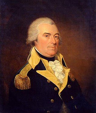
Anthony Wayne was an American soldier, officer, statesman, and a Founding Father of the United States. He adopted a military career at the outset of the American Revolutionary War, where his military exploits and fiery personality quickly earned him a promotion to brigadier general and the nickname "Mad Anthony". He later served as the Senior Officer of the Army on the Ohio Country frontier and led the Legion of the United States.

Little Turtle was a Sagamore (chief) of the Miami people, who became one of the most famous Native American military leaders. Historian Wiley Sword calls him "perhaps the most capable Indian leader then in the Northwest Territory," although he later signed several treaties ceding land, which caused him to lose his leader status during the battles which became a prelude to the War of 1812. In the 1790s, Mihšihkinaahkwa led a confederation of native warriors to several major victories against U.S. forces in the Northwest Indian Wars, sometimes called "Little Turtle's War", particularly St. Clair's defeat in 1791, wherein the confederation defeated General Arthur St. Clair, who lost 900 men in the most decisive loss by the U.S. Army against Native American forces.

The Miami are a Native American nation originally speaking one of the Algonquian languages. Among the peoples known as the Great Lakes tribes, they occupied territory that is now identified as north-central Indiana, southwest Michigan, and western Ohio. The Miami were historically made up of several prominent subgroups, including the Piankeshaw, Wea, Pepikokia, Kilatika, Mengakonkia, and Atchakangouen. In modern times, Miami is used more specifically to refer to the Atchakangouen. By 1846, most of the Miami had been forcefully displaced to Indian Territory. The Miami Tribe of Oklahoma are the federally recognized tribe of Miami Indians in the United States. The Miami Nation of Indiana, a nonprofit organization of self-identified descendants of Miamis who were exempted from removal, have unsuccessfully sought separate recognition.

Tecumseh was a Shawnee chief and warrior who promoted resistance to the expansion of the United States onto Native American lands. A persuasive orator, Tecumseh traveled widely, forming a Native American confederacy and promoting intertribal unity. Even though his efforts to unite Native Americans ended with his death in the War of 1812, he became an iconic folk hero in American, Indigenous, and Canadian popular history.

The Northwest Territory, also known as the Old Northwest and formally known as the Territory Northwest of the River Ohio, was formed from unorganized western territory of the United States after the American Revolution. Established in 1787 by the Congress of the Confederation through the Northwest Ordinance, it was the nation's first post-colonial organized incorporated territory.

The Battle of Fallen Timbers was the final battle of the Northwest Indian War, a struggle between Native American tribes affiliated with the Northwestern Confederacy and their British allies, against the nascent United States for control of the Northwest Territory. The battle took place amid trees toppled by a tornado near the Maumee River in northwestern Ohio at the site of the present-day city of Maumee, Ohio.

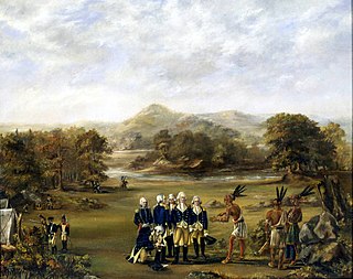
The Treaty of Greenville, also known to Americans as the Treaty with the Wyandots, etc., but formally titled A treaty of peace between the United States of America, and the tribes of Indians called the Wyandots, Delawares, Shawanees, Ottawas, Chippewas, Pattawatimas, Miamis, Eel Rivers, Weas, Kickapoos, Piankeshaws, and Kaskaskias was a 1795 treaty between the United States and indigenous nations of the Northwest Territory, including the Wyandot and Delaware peoples, that redefined the boundary between indigenous peoples' lands and territory for European American community settlement.
The Northwest Indian War (1785–1795), also known by other names, was an armed conflict for control of the Northwest Territory fought between the United States and a united group of Native American nations known today as the Northwestern Confederacy. The United States Army considers it the first of the American Indian Wars.

William Wells, also known as Apekonit, was the son-in-law of Chief Little Turtle of the Miami. He fought for the Miami in the Northwest Indian War. During the course of that war, he became a United States Army officer, and also served in the War of 1812.

Fort Recovery was a United States Army fort ordered built by General "Mad" Anthony Wayne during what is now termed the Northwest Indian War. Constructed from late 1793 and completed in March 1794, the fort was built along the Wabash River, within two miles of what became the Ohio state border with Indiana. A detachment of Wayne's Legion of the United States held off an attack from combined Indian forces on June 30, 1794. The fort was used as a reference in drawing treaty lines for the 1795 Treaty of Greenville, and for later settlement. The fort was abandoned in 1796.

The Legion of the United States was a reorganization and extension of the United States Army from 1792 to 1796 under the command of Major General Anthony Wayne. It represented a political shift in the new United States, which had recently adopted the United States Constitution. The new Congressional and Executive branches authorized a standing army composed of professional soldiers rather than relying on state militias.

Fort Miami (Miamis) was a British fort built in spring 1794 on the Maumee River in what was at the time territory claimed by the United States, and designated by the federal government as the Northwest Territory. The fort was located at the eastern edge of present-day Maumee, Ohio, southwest of Toledo. The British built the fort to forestall a putative assault on Fort Detroit by Gen. "Mad" Anthony Wayne's army, then advancing northward in southwestern Ohio.
Egushawa, also spelled Egouch-e-ouay, Agushaway, Agashawa, Gushgushagwa, Negushwa, and many other variants, was a war chief and principal political chief of the Ottawa tribe of North American Indians. His name is loosely translated as "The Gatherer" or "Brings Together". He was a prominent leader among the Detroit Ottawa, a prominent group in southeast Michigan and northwest Ohio. Egushawa is considered a successor to Chief Pontiac. As a leader in two wars against the United States, Egushawa was one of the most influential Native Americans of the Great Lakes region in the late eighteenth century.

The Battle of Fort Recovery, 30 June – 1 July 1794, was a battle of the Northwest Indian War, fought at the present-day village of Fort Recovery, Ohio. A large force of warriors in the Western Confederacy attacked a fort held by United States soldiers deep in Ohio Country. The United States suffered heavy losses, but maintained control of the fort. The battle exposed a division in the Western Confederacy's military strategy at a time when they seemed to hold the advantage, and the United States pressed farther into the Northwest Territory.
Snake was the English language name of two Shawnee leaders prominent in the history of the Ohio Country: Peteusha and Shemanetoo. They were both commonly referred to as "Snake" in historical records, or by variations such as "Black Snake" or "Captain Snake," so it is often difficult to determine which individual was being referred to. On a number of occasions, the two Snakes both signed a letter or appeared together, so it is clear they were two different people. There may have been additional Shawnees called "Snake," further complicating the matter. According to historian John Sugden, "it is unlikely if the biographies of these chiefs will ever be completely disentangled."
Five Medals was a leader of the Elkhart River Potawatomi. He led his people in defense of their homelands and was a proponent of agriculture. Five Medals first appeared in eastern records after the Battle of Fallen Timbers, but disappears from those records shortly after the end of the War of 1812.
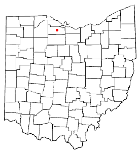
The Two Mile Square Reservation or Two Mile Square Reserve was a tract of land in Ohio ceded by Native Americans to the United States of America in the Treaty of Greenville in 1795. It was subsequently surveyed in a manner different from surrounding land, and lots sold to settlers.
Indian removals in Ohio started in the late eighteenth century after the American victory in the Revolutionary War and the consequent opening of the Northwestern United States to European-American settlement. Native American tribes residing in the region banded together to resist settlement, resulting in the disastrous Northwest Indian War where the Native tribes ceded large swathes of territory to the American government. After the American victory in the war, several Indian reservations were established to forcibly relocate landless tribes to. The process of obtaining full American sovereignty over Indian territories in Ohio was complete around 1818, but continued in Indiana until 1840.

Quatawapea or John Lewis, also known as Captain Lewis and Colonel Lewis and ‘’’Captain Johnny’’’, was a Shawnee leader for whom Lewistown, Ohio, is named.
Kekewepelethy, also known as Captain Johnny, was the principal civil chief of the Shawnees in the Ohio Country during the Northwest Indian War (1786–1795). He first came to prominence during the American Revolutionary War (1775–1783), in which he, like most of his fellow Mekoche Shawnees, initially sought to remain neutral. He joined the war against the United States around 1780, moving to Wakatomika, a Shawnee town known for its militant defense of the Ohio Country.