Lake County is one of the 36 counties in the U.S. state of Oregon. As of the 2020 census, the population was 8,160. Its county seat is Lakeview. The county is named after the many lakes found within its boundaries, including Lake Abert, Summer Lake, Hart Lake, and Goose Lake.

Elkton is a city in Douglas County, Oregon, United States. It is located on the lower Umpqua River, at the junction of Oregon Route 38 and Oregon Route 138, about 20 miles (32 km) west of Interstate 5 and about 14 miles (23 km) west of Drain. The population was 195 at the 2010 census, an increase from 147 people in 2000.

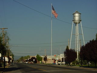
Chiloquin is a city in Klamath County, Oregon, United States. Chiloquin was the pioneer version of a Klamath family name Chaloquin, which was the name of a Klamath chief who was alive at the time of the treaty of 1864. Southern Pacific records also show that a woman named Bessie Chiloquin deeded a right-of-way through the area to the railroad on February 14, 1914. The population was 734 at the 2010 census.

Klamath Falls is a city in and the county seat of Klamath County, Oregon, United States. The city was originally called Linkville when George Nurse founded the town in 1867. It was named after the Link River, on whose falls the city was sited. The name was changed to Klamath Falls in 1893. The population was 20,840 at the 2010 census. The city is on the southeastern shore of the Upper Klamath Lake located about 246 miles (396 km) northwest of Reno, Nevada, and approximately 17 miles (27 km) north of the California–Oregon border.
Merrill is a city in Klamath County, Oregon, United States. The population was 844 at the 2010 census.

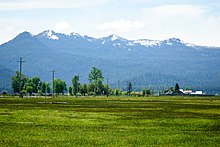
Modoc Point is a cliff on the east shore of Upper Klamath Lake, in Klamath County, Oregon, United States, approximately 15 miles north of Klamath Falls on U.S. Route 97. It is part of the larger cliff known as Modoc Rim or Modoc Ridge.

Bly is an unincorporated small town in Klamath County, Oregon, United States. By highway, it is about 50 miles (80 km) east of Klamath Falls. As of 2020, the population was 207.
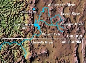
The Sprague River is a tributary of the Williamson River, approximately 75 miles (121 km) long, in southwestern Oregon in the United States. It drains an arid volcanic plateau region east of the Cascade Range in the watershed of the Klamath River.

Adel is an unincorporated community in southeastern Lake County, in the U.S. state of Oregon. The community is in an arid, sparsely populated part of the state, along Oregon Route 140, about 30 miles (48 km) east of Lakeview. The Warner Valley surrounding Adel contains many marshes and shallow lakes, most of them intermittent.
Midland is an unincorporated community in Klamath County, Oregon, United States, about 8 miles (13 km) south of Klamath Falls on U.S. Route 97. The site was platted in 1908 and named Midland, with a post office established in 1909. At the time it was said the name was chosen because the town was halfway between Portland and San Francisco on the proposed Cascade Line of the Southern Pacific Railroad. It is not halfway, however, and it is now thought that the name refers to the town's site on land partly surrounded by marshes.
Beatty is an unincorporated community and census-designated place (CDP) in Klamath County, Oregon, United States. Beatty is along Oregon Route 140 at the confluence of the Sycan and Sprague rivers and is 40 miles (64 km) by highway northeast of Klamath Falls.
Sprague River is an unincorporated community in Klamath County, Oregon, United States. It is about 45 miles (72 km) northeast of Klamath Falls near the Sprague River, northwest of Oregon Route 140.
Dairy is an unincorporated community in Klamath County, Oregon, United States.

Silver Lake is an unincorporated community and census-designated place in western Lake County, Oregon, United States, along Oregon Route 31. As of the 2010 census, it had a population of 149. Facilities include a gas station and a small store, a post office, and a public school, North Lake School, serving grades K-12.

Keno is an unincorporated community in Klamath County, Oregon, United States, southwest of Klamath Falls on the Klamath River near Oregon Route 66. As of 2000, the population was 1,059. Keno's elevation is 4,108 feet (1,252 m) above sea level.

Curtin is an unincorporated community in Douglas County, Oregon, United States. It is on Interstate 5 and the former Southern Pacific railroad line about 7 miles (11 km) northeast of Drain along Pass Creek. It stands at an elevation of 404 feet.
Modoc Point is an unincorporated community in Klamath County, Oregon, United States on U.S. Route 97 on the shore of Upper Klamath Lake.

Rocky Point is an unincorporated community in Klamath County, Oregon, United States. It is on Pelican Bay on the west shore of Upper Klamath Lake, about 29 miles (47 km) northwest of Klamath Falls and about 3 miles (5 km) north of Oregon Route 140 on Forest Highway 34. It is within the Winema National Forest.
Beaver Marsh is an unincorporated community in Klamath County, Oregon, United States. It is located on U.S. Route 97, about 6 miles south of Chemult. The Southern Pacific Cascade Line passes near the locale.
Cascade Summit is an unincorporated community in Klamath County, Oregon, United States. It is located on the west shore of Odell Lake near Shelter Cove; about 30 miles southeast of Oakridge.