
Monroe County is a county on the eastern border of the U.S. state of Tennessee. As of the 2020 census, the population was 46,250. Its county seat is Madisonville.
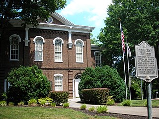
Loudon County is a county in the U.S. state of Tennessee. It is located in the central part of East Tennessee. As of the 2020 census, the population was 54,886. Its county seat is Loudon. Loudon County is included in the Knoxville, TN Metropolitan Statistical Area.

Jones County is a county in the U.S. state of Iowa. As of the 2020 census the population was 20,646. The county seat is Anamosa. The county was founded in 1837 and named after George Wallace Jones, a United States senator and member of Congress.

Vonore is a town in Monroe County, which is located on the southeast border of the U.S. state of Tennessee. The population was 1,574 as of the 2020 census. The city hall, library, community center, police department, and fire department are located on Church Street.

The Little Tennessee River is a 135-mile (217 km) tributary of the Tennessee River that flows through the Blue Ridge Mountains from Georgia, into North Carolina, and then into Tennessee, in the southeastern United States. It drains portions of three national forests— Chattahoochee, Nantahala, and Cherokee— and provides the southwestern boundary of the Great Smoky Mountains National Park.
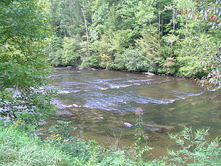
The Tellico River is a river in the Blue Ridge Mountains of western North Carolina and eastern Tennessee. It rises in the westernmost mountains of North Carolina, and then flows through Monroe County, Tennessee, before joining the Little Tennessee River under the Tellico Reservoir. With a length of 52.8 miles (85.0 km), it is a major tributary of the Little Tennessee River, and is one of the primary streams draining the Unicoi Mountains.

San Marcos de Apalache Historic State Park is a Florida State Park in Wakulla County, Florida organized around the historic site of a Spanish colonial fort, which was used by succeeding nations that controlled the area. The Spanish first built wooden buildings and a stockade in the late 17th and early 18th centuries here, which were destroyed by a hurricane.

Tuskegee was an Overhill Cherokee town located along the lower Little Tennessee River in what is now Monroe County, Tennessee, United States. The town developed in the late 1750s alongside Fort Loudoun, and was inhabited until the late 1770s. It was forcibly evacuated and probably burned during the Cherokee–American wars.

Chota is a historic Overhill Cherokee town site in Monroe County, Tennessee, in the southeastern United States. Developing after nearby Tanasi, Chota was the most important of the Overhill towns from the late 1740s until 1788. It replaced Tanasi as the de facto capital, or 'mother town' of the Cherokee people.
The Cherokee Path was the primary route of English and Scots traders from Charleston to Columbia, South Carolina in Colonial America. It was the way they reached Cherokee towns and territories along the upper Keowee River and its tributaries. In its lower section it was known as the Savannah River. They referred to these towns along the Keowee and Tugaloo rivers as the Lower Towns, in contrast to the Middle Towns in Western North Carolina and the Overhill Towns in present-day southeastern Tennessee west of the Appalachian Mountains.

Fort Loudoun was a British fort located in what is now Monroe County, Tennessee. Constructed from 1756 until 1757 to help garner Cherokee support for the British at the outset of the French and Indian War, the fort was one of the first significant British outposts west of the Appalachian Mountains. The fort was designed by John William Gerard de Brahm, while its construction was supervised by Captain Raymond Demeré; the fort's garrison was commanded by Demeré's brother, Paul Demeré. It was named for the Earl of Loudoun, the commander of British forces in North America at the time.
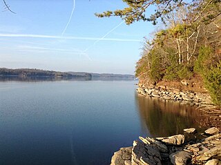
Watts Bar Lake is a reservoir on the Tennessee River created by Watts Bar Dam as part of the Tennessee Valley Authority system.

Fort Loudoun Dam is a hydroelectric dam on the Tennessee River in Loudon County, Tennessee, in the southeastern United States. The dam is operated by the Tennessee Valley Authority (TVA), which built the dam in the early 1940s as part of a unified plan to provide electricity and flood control in the Tennessee Valley and create a continuous 652-mile (1,049 km) navigable river channel from Knoxville, Tennessee to Paducah, Kentucky. It is the uppermost of nine TVA dams on the Tennessee River.

Moreau Lake State Park is a 6,250-acre (2,530 ha) state park in Saratoga County, New York, United States.

The Tellico Blockhouse was an early American outpost located along the Little Tennessee River in what developed as Vonore, Monroe County, Tennessee. Completed in 1794, the blockhouse was a US military outpost that operated until 1807; the garrison was intended to keep peace between the nearby Overhill Cherokee towns and encroaching early Euro-American pioneers in the area in the wake of the Cherokee–American wars.

Overhill Cherokee was the term for the Cherokee people located in their historic settlements in what is now the U.S. state of Tennessee in the Southeastern United States, on the western side of the Appalachian Mountains. This name was used by 18th-century European traders and explorers from British colonies along the Atlantic coast, as they had to cross the mountains to reach these settlements.

Wesser Bald is a summit located in Macon County, North Carolina, near the community of Wesser. A wooden fire tower at the summit provides hikers with unimpeded views of the Great Smoky Mountains National Park and also the Nantahala Mountains. The Appalachian Trail traverses the summit from roughly north to south with the Nantahala Outdoor Center lying to the north within the Nantahala Gorge and Tellico gap just to the south. Tellico gap has unimproved road access. The climb from Tellico Gap takes an average of 20 minutes. Also, a third route, the blue trail, departs from the end of Wesser Creek Road and follows Wesser Creek up to a point just south of the summit to a fork with the Appalachian Trail. The summit is located at 4,627 ft (1,410 m). and is within Nantahala National Forest. A map detailing the highway routes to access Tellico Gap is available at the Nantahala Outdoor Center. Observable landforms include Wayah Bald, the Nantahala Gorge, and Clingmans Dome among others. The Wesser Fire Tower provides 360 degree views of the Smokies in a short 1.5 mile hike from Tellico Gap on the Appalachian Trail, with an elevation gain of about 767 feet. The Fire Tower was originally reported as destroyed during the forest fires which ravaged the Nantahala Forest in November, 2016 but it was later learned that it survived.

Tomotley is a prehistoric and historic Native American site along the lower Little Tennessee River in Monroe County, Tennessee, in the southeastern United States. Occupied as early as the Archaic period, the Tomotley site was occupied particularly during the Mississippian period, which was likely when its earthwork platform mounds were built. It was also occupied during the eighteenth century as a Cherokee town. It revealed an unexpected style: an octagonal townhouse and square or rectangular residences. In the Overhill period, Cherokee townhouses found in the Carolinas in the same period were circular in design, with,
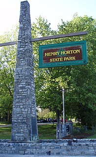
Henry Horton State Park is a state park located near Chapel Hill, Tennessee, United States. It was constructed in the 1960s on the estate of the former Governor of Tennessee Henry Horton. The park offers canoeing, camping, lodging, hiking and other activities.
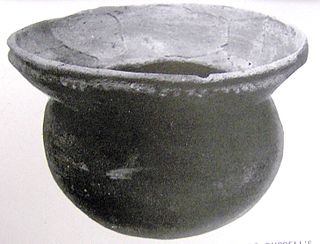
Bussell Island, formerly Lenoir Island, is an island located at the mouth of the Little Tennessee River, at its confluence with the Tennessee River in Loudon County, near the U.S. city of Lenoir City, Tennessee. The island was inhabited by various Native American cultures for thousands of years before the arrival of early European explorers. The Tellico Dam and a recreational area occupy part of the island. Part of the island was added in 1978 to the National Register of Historic Places for its archaeological potential.

