
A swamp is a forested wetland. Swamps are considered to be transition zones because both land and water play a role in creating this environment. Swamps vary in size and are located all around the world. The water of a swamp may be fresh water, brackish water, or seawater. Freshwater swamps form along large rivers or lakes where they are critically dependent upon rainwater and seasonal flooding to maintain natural water level fluctuations. Saltwater swamps are found along tropical and subtropical coastlines. Some swamps have hammocks, or dry-land protrusions, covered by aquatic vegetation, or vegetation that tolerates periodic inundation or soil saturation. The two main types of swamp are "true" or swamp forests and "transitional" or shrub swamps. In the boreal regions of Canada, the word swamp is colloquially used for what is more formally termed a bog, fen, or muskeg. Some of the world's largest swamps are found along major rivers such as the Amazon, the Mississippi, and the Congo.

Obion County is a county located in the northwest corner of the U.S. state of Tennessee. As of the 2020 census, the population was 30,787. The county seat is Union City. The county was formed in 1823 and organized in 1824. It was named after the Obion River.

Lake County is a county located in the northwest corner of the U.S. state of Tennessee. As of the 2020 census, the population was 7,005, making it the fifth-least populous county in Tennessee. Its county seat is Tiptonville. It shares a border with Kentucky to the north and is separated from Missouri to the west by the Mississippi River.
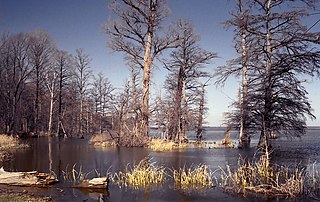
Reelfoot Lake is a shallow natural lake located in the northwest portion of the U.S. state of Tennessee, in Lake and Obion Counties. Much of it is swamp-like, with bayou-like ditches connecting more open bodies of water called basins, the largest of which is called Blue Basin. Reelfoot Lake is noted for its bald cypress trees and its nesting pairs of bald eagles.
Reelfoot Lake State Park is a state park in the northwest corner of Tennessee in the United States. It encompasses Reelfoot Lake and is situated in Lake and Obion counties. The park itself makes up 280 acres (1.1 km2), divided into ten sections around the lake. A major hunting and fishing preserve, it is part of a much larger wildlife refuge which comprises 25,000 acres (100 km2), 15,000 acres (61 km2) of which are water, and harbors almost every kind of shorebird, as well as the golden and American bald eagles. Other animals are also diverse and abundant. The many species of flowering and non-flowering plants attract botany enthusiasts from all over the country. Baldcypress dominates the margins of the lake, but many other trees and shrubs are also present.
The Wheeler National Wildlife Refuge is a 35,000-acre (142 km2) national wildlife refuge (NWR) located along the Tennessee River near Decatur, Alabama. Named after Major General Joseph Wheeler, it was established to provide a habitat for wintering and migrating birds in the Eastern United States.

Swan River National Wildlife Refuge is a 1,778-acre (720 ha) National Wildlife Refuge in Lake County of northwestern Montana. It is a unit of the National Bison Range Complex.
Lake Mason National Wildlife Refuge is located in the center of the U.S. state of Montana. The refuge has numerous lakes and extensive marshlands along Willow Creek, which provide nesting habitat for over a hundred bird species. The refuge is managed from the Charles M. Russell National Wildlife Refuge and is normally unstaffed and has few visitor improvements. The refuge consists of three discontinuous areas; the Lake Mason area which has seasonal wetlands, the North section consisting primarily of uplands and the Willow Creek section which was set aside to protect habitat for the mountain plover.
Key Cave National Wildlife Refuge is a 1,060 acre (4.3 km2) National Wildlife Refuge located in northwestern Alabama, along the Tennessee River downstream from Florence, Alabama. Additional purchases are under negotiation which will increase the size of the refuge to 1,800 acres (7.3 km2).
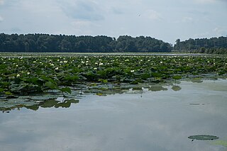
Lake Isom is a small natural lake located in Lake County, Tennessee immediately south of Reelfoot Lake. It is fed by Running Reelfoot Bayou, the outlet stream of Reelfoot Lake. Like Reelfoot, it was formed in the 1811–12 New Madrid earthquakes and it is very shallow and swampy. The entire lake and its environs, covering 1,846 acres comprise the Lake Isom National Wildlife Refuge and have been such since 1938.
Cross Creeks National Wildlife Refuge is a part of the U.S. system of National Wildlife Refuges located along the Lake Barkley impoundment of the Cumberland River in Stewart County, Tennessee near Dover, covering 8,862 acres (35.86 km2). It provides habitat for a wide variety of waterfowl and aquatic plant life in what is a largely wetlands environment. Cross Creeks is the only National Wildlife Refuge located entirely in Middle Tennessee as of 2006.
Crab Orchard National Wildlife Refuge is a 43,890 acre (180 km2) National Wildlife Refuge primarily in southwestern Williamson County, but with small extensions into adjacent eastern Jackson and northeastern Union counties of southern Illinois, in the United States. Its land and water contain a wide diversity of flora and fauna. It centers on Crab Orchard Lake. Major habitat types on the refuge include hardwood forest, agricultural land, grazing units, brushland, wetlands, and lakes. Other major bodies of water on the refuge are Devil's Kitchen Lake and Little Grassy Lake.

State Route 157 is a short secondary highway in northern Obion County, Tennessee.

Nantucket National Wildlife Refuge is a 24-acre (9.7 ha) range and was established in 1973 for its "particular value in carrying out the national migratory bird management program." The refuge, which is cooperatively managed with The Trustees of Reservations, encompasses 24 acres (9.7 ha) at Great Point. Nantucket National Wildlife Refuge is an un-staffed unit of the Eastern Massachusetts National Wildlife Refuge Complex. Nantucket National Wildlife Refuge consists of the Northeast tip of Nantucket, known as Great Point. The Refuge has been managed informally by TTOR several decades. TTOR owns the land immediately adjacent to Great Point, known as the Coskata-Coatue Wildlife Refuge. Great Point is known as one of the best surfcasting locations in New England because of the rip tide which brings bluefish and striped bass to the point. The Refuge is also a destination for hundreds of visitors each year seeking to enjoy a Nantucket beach or a tour of the Great Point Lighthouse. More information about the adjacent TTOR property is available on their website.

Swan Lake National Wildlife Refuge is a 10,795-acre (43.69 km2) National Wildlife Refuge established in 1937 and located in Chariton County, Missouri, 2 miles (3.2 km) south of the town of Sumner. It is located near the confluence of the Grand and Missouri Rivers.
Ardoch National Wildlife Refuge is a National Wildlife Refuge in Walsh County, North Dakota. It is managed under Devils Lake Wetland Management District.
Canfield Lake National Wildlife Refuge is a National Wildlife Refuge in Burleigh County, North Dakota. It is a privately owned property with refuge easement rights for flooding with 3 acres owned in fee, and is one of six easement refuges managed under Long Lake National Wildlife Refuge. It is closed to hunting.
Slade National Wildlife Refuge is a 3,000-acre (12 km2) National Wildlife Refuge in Kidder County, North Dakota. It was established in 1941 when the property was donated by G.T. Slade, a Northern Pacific Railroad executive. It is managed under the Long Lake National Wildlife Refuge. It contains Harker Lake and Upper Harker Lake.
West Tennessee National Wildlife Refuge Complex is a National Wildlife Refuge complex in the state of Tennessee.
The Mississippi River Trail is a designated bicycle and pedestrian trail that traverses the shores of the Mississippi River in the United States. The trail extends from the headwaters at Lake Itasca in Minnesota to near the mouth of the river in Venice, Louisiana. Much of the trail’s 3,000 miles (4,800 km) follows roadways used by motor vehicles, although some of the route is on multi-use trails. The segment in Minnesota has been designated as U.S. Bicycle Route 45, part of the U.S. Bicycle Route System.
