Tiptonville, Tennessee | |
---|---|
Coordinates: 36°22′39″N89°28′34″W / 36.37750°N 89.47611°W | |
Country | United States |
State | Tennessee |
County | Lake |
Established | 1857 [1] |
Incorporated | 1900 [1] |
Named for | William Tipton (early settler) [2] |
Area | |
• Total | 3.34 sq mi (8.65 km2) |
• Land | 3.31 sq mi (8.59 km2) |
• Water | 0.02 sq mi (0.06 km2) |
Elevation | 302 ft (92 m) |
Population | |
• Total | 3,976 |
• Density | 1,199.40/sq mi (463.02/km2) |
Time zone | UTC-6 (Central (CST)) |
• Summer (DST) | UTC-5 (CDT) |
ZIP code | 38079 |
Area code | 731 |
FIPS code | 47-74540 [6] |
GNIS feature ID | 1272690 [4] |
Website | tiptonville.org |
Tiptonville is a town in and the county seat of Lake County, Tennessee, United States. [7] Its population was 2,439 as of the 2000 census and 4,464 in 2010, showing an increase of 2,025. It is also home to the Northwest Correctional Complex, a maximum security prison, known for once housing mass murderer Jessie Dotson.
Tiptonville was established in 1857, but was not incorporated until 1900. It was designated the county seat when Lake County was created in 1870. [1]
Tiptonville was the scene of the surrender of Confederate forces at the end of the 1862 Battle of Island Number Ten in the American Civil War. The monument for this battle is located on State Route 22 approximately three miles north of Tiptonville, since the island itself, the focal point of the battle, has been eroded by the flow of the Mississippi River and no longer exists.
On March 19, 1901, Tiptonville was destroyed by a fire three days after a mob of white townsmen had lynched Ike Fitzgerald, a black man accused of raping a white woman. Whites speculated that the blaze, which burned 30 buildings and residences, including all of the stores on the main street, had been deliberately set by African Americans in reprisal for Fitzgerald's lynching. [8] [9] [10] [11]
Tiptonville is located at 36°22′39″N89°28′34″W / 36.37750°N 89.47611°W (36.377610, −89.476022), [12] on a small rise known as the Tiptonville Dome [1] and within the New Madrid Seismic Zone. The Mississippi River is to the west and north, the Kentucky Bend is to the north, and Reelfoot Lake is to the east.
According to the United States Census Bureau, the town has a total area of 1.4 square miles (3.6 km2), all land.
Census | Pop. | Note | %± |
---|---|---|---|
1880 | 946 | — | |
1890 | 363 | −61.6% | |
1910 | 843 | — | |
1920 | 1,050 | 24.6% | |
1930 | 1,359 | 29.4% | |
1940 | 1,503 | 10.6% | |
1950 | 1,953 | 29.9% | |
1960 | 2,068 | 5.9% | |
1970 | 2,407 | 16.4% | |
1980 | 2,438 | 1.3% | |
1990 | 2,149 | −11.9% | |
2000 | 2,439 | 13.5% | |
2010 | 4,464 | 83.0% | |
2020 | 3,976 | −10.9% | |
Sources: [13] [14] [5] |
As of the census [6] of 2000, there were 2,439 people, 918 households, and 570 families residing in the town. The population density was 1,704.0 inhabitants per square mile (657.9/km2). There were 992 housing units at an average density of 693.1 per square mile (267.6/km2). The racial makeup of the town was 62.57% White, 36.16% African American, 0.33% Native American, 0.08% Asian, 0.12% from other races, and 0.74% from two or more races. Hispanic or Latino of any race were 0.82% of the population.
There were 918 households, out of which 26.8% had children under the age of 18 living with them, 38.5% were married couples living together, 19.4% had a female householder with no husband present, and 37.9% were non-families. 35.2% of all households were made up of individuals, and 19.1% had someone living alone who was 65 years of age or older. The average household size was 2.23 and the average family size was 2.87.
In the town, the population was spread out, with 20.7% under the age of 18, 9.4% from 18 to 24, 28.3% from 25 to 44, 23.2% from 45 to 64, and 18.4% who were 65 years of age or older. The median age was 40 years. For every 100 females, there were 102.7 males. For every 100 females age 18 and over, there were 103.9 males.
The median income for a household in the town was $19,475, and the median income for a family was $24,929. Males had a median income of $25,089 versus $18,333 for females. The per capita income for the town was $11,843. About 21.1% of families and 26.5% of the population were below the poverty line, including 43.0% of those under age 18 and 28.7% of those age 65 or over.
A local newspaper, The Lake County Banner, is published in Tiptonville.
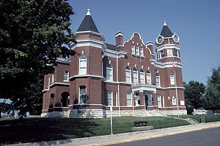
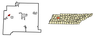
Obion County is a county located in the northwest corner of the U.S. state of Tennessee. As of the 2020 census, the population was 30,787. The county seat is Union City. The county was formed in 1823 and organized in 1824. It was named after the Obion River.
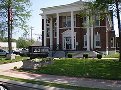
Lake County is a county located in the northwest corner of the U.S. state of Tennessee. As of the 2020 census, the population was 7,005, making it the fifth-least populous county in Tennessee. Its county seat is Tiptonville. It shares a border with Kentucky to the north and is separated from Missouri to the west by the Mississippi River.
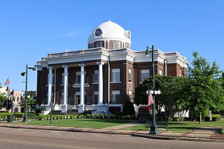
Dyer County is a county located in the westernmost part of the U.S. state of Tennessee. As of the 2020 census, the population was 36,801. The county seat is Dyersburg. Dyer County comprises the Dyersburg, TN Micropolitan Statistical Area.
Logan County is a county in the southwest Pennyroyal Plateau area of the U.S. Commonwealth of Kentucky. As of the 2020 census, the population was 27,432. Its county seat is Russellville.
Fulton County is the westernmost county in the U.S. state of Kentucky, with the Mississippi River forming its western boundary. As of the 2020 census, the population was 6,515. Its county seat is Hickman and its largest city is Fulton. The county was formed in 1845 from Hickman County, Kentucky and named for Robert Fulton, the inventor of the steamboat.
London is a census designated place (CDP) in Tulare County, California, United States. The population was 1,869 at the 2010 census, up from 1,848 at the 2000 census.
Walton is a town in Tipton Township, Cass County, Indiana, United States. The population was 1,049 at the 2010 census.
Lynch is a home rule-class city in Harlan County, Kentucky, United States. In the 2020 census the city population was 658, down from 747 in 2010.
Trezevant is a town in Carroll County, Tennessee. The population was 1,001 at the 2020 census and 959 at the 2010 census.
Newbern is a town in Dyer County, Tennessee. As of the 2010 census, the town population was 3,313.
Ridgely is a town in Lake County, Tennessee, United States. The population was 1,667 at the 2000 census and 1,795 at the 2010 census.
Henning is a town in Lauderdale County, Tennessee, United States. The population was 945 at the 2010 census.
Hornbeak is a town in Obion County, Tennessee, United States. The population was 424 as of the 2010 census. It is part of the Union City, TN–KY Micropolitan Statistical Area.
Obion is a town in Obion County, Tennessee, United States, along the Obion River. The population was 1,119 at the 2010 census. It is part of the Union City, TN–KY Micropolitan Statistical Area.
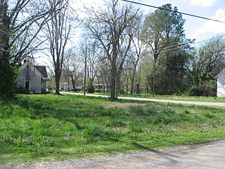
Rives is a town in Obion County, Tennessee. The population was 312 at the 2020 census. It is part of the Union City, TN–KY Micropolitan Statistical Area.
Samburg is a town in Obion County, Tennessee, United States. The population was 210 at the 2020 census. Samburg is located on the eastern shores of Reelfoot Lake.
Byrdstown is a town in Pickett County, Tennessee, United States. The population was 798 at the 2020 census. It is the county seat of Pickett County.
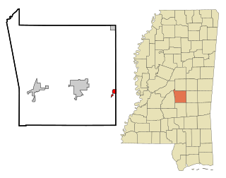
Lake is a town in Newton and Scott counties, Mississippi. The population was 408 at the 2000 census.
Kenton is a town in Gibson and Obion counties, Tennessee. The population was 1,281 at the 2010 census, a decline of 25 from 2000. The Gibson County portion of Kenton is part of the Humboldt, TN Micropolitan Statistical Area, while the Obion County portion is part of the Union City, TN–KY Micropolitan Statistical Area.
Golinda is a city in Falls and McLennan counties in the U.S. state of Texas. The population was 618 at the 2020 census, an increase over the figure of 559 tabulated in 2010.