In 1805, the Cherokee ceded what is now Morgan County to the United States by signing the Third Treaty of Tellico. The first settlers arrived in the area shortly thereafter.[8]
Wartburg was founded in the mid-1840s by Georg Friedrich Gerding (later anglicized as George Frederick), a land speculator who bought up large tracts of land in what is now Morgan County and organized the East Tennessee Colonization Company with plans to establish a series of German colonies in the Cumberland region.
Born in Germany in 1800, he became a successful businessman after moving to New York. He was decorated by Belgium King Leopold I for establishing the first ship line between Antwerp and New York. He was U.S. Consul to Baden-Baden 1845-47. Acquiring 300,000 acres of land, he established the East Tennessee Land Colonization Co. for Swiss, German, and French immigrants. In 1844, he founded Wartburg, and gave land for the town square, a church, and a cemetery. He died in 1884.[9]
German and Swiss immigrants, seeking to escape poor economic conditions in their home counties, arrived at the site by traveling from New Orleans up the Mississippi and Cumberland rivers to Nashville, and then by ox cart to the Cumberland Plateau. The first of these settlers arrived in the area in 1845, and new groups of immigrants would continue trickling in until 1855.[10]
The new settlement, which had already been platted by East Tennessee Colonization Company agent Friedrich Guenther, was named after Wartburg Castle in Germany.
“The city was named after the German Wartburg, where Martin Luther translated the New Testament and parts of the Old Testament into German.”
The first six streets were initially named for European cities, but the names were changed within a few years to Rose, Church, Maidenland (now Maiden), Kingston, Mill, and Cumberland. As most immigrants lived on farms outside the town, Wartburg grew slowly. By 1850, the town consisted of Gerding's house and store, a church and school building, a doctor's office, and a few small houses. Early residents included a number of professionals trained in Europe, including architect Carl Rothe, musician Gustav Knabe, painter George Dury,[11] and physicians Rudolf Knaffl and F. A. Sienknecht.[10][12][2] Gerding and the retired German officer Friedrich Karl Georg Freiherr von Forstner (1800–1861), who arrived with his family in 1847 and bought 1,500 acres, were the largest landowners.
While Morgan County was generally pro-Union during the Civil War, Wartburg was bitterly divided over the secession issue. Gerding, the city's founder, supported the Confederacy. John Wilken, a prominent Lutheran pastor in the city, supported the Union. F.A. Sienknecht supported the Union, though two of his sons fought for the Confederacy.[13] On January 2, 1862, a Confederate cavalry unit under Colonel J.W. White clashed with the Union Home Guard near Wartburg. In late March 1862, Confederate General Kirby Smith reported that all Confederate citizens had been expelled from the Wartburg area. In June 1863, Union General William P. Sanders marched through Wartburg and captured 104 Confederate soldiers in the vicinity.[14]
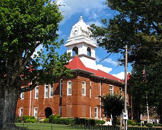
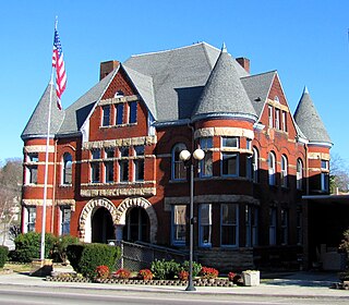
In 1870, Morgan County elected to move its county seat from the now-defunct town of Montgomery, which had a population of just 50 residents and had been economically overshadowed by Wartburg. A new courthouse, consisting of a simple frame structure, was completed in 1871.[15][16] The current Richardsonian Romanesque-style courthouse was built in 1904.[17]
By the early 20th century, Wartburg had grown modestly, reporting a population of about 500 in 1920. At this time, the city included a bank, school, newspaper, four general stores, a clothing store, a hardware store, and a billiard hall.[18] In 1968, Wartburg voted to incorporate, and elected Roy McNeal as its mayor.[1]
Wartburg is situated amidst the Crab Orchard Mountains, a sub-range of the Cumberland Mountains, near the eastern edge of the Cumberland Plateau. Bird Mountain dominates the area east of Wartburg, rising from its base at the edge of the city and stretching for some 10 miles (16km) to its 3,142-foot (958m) summit at Frozen Head State Park. The Emory River, its source near the summit of Bird, flows westwardly along the mountain's northern base, passing just north of Wartburg, and turning south before dropping off the plateau and emptying into the Watts Bar Lake impoundment of the Tennessee River. The Obed River flows eastwardly from Cumberland County through a scenic gorge before emptying into the Emory just west of Wartburg.
Wartburg is situated around the junction of U.S. Route 27, which connects the city to Kentucky to the north and Harriman and Interstate 40 to the south, and State Route 62, which connects Wartburg to Oak Ridge to the east and the rural areas of Morgan County and Fentress County to the west.
According to the United States Census Bureau, the city has a total area of 1.0 square mile (2.6km2), all of it land.
As of the 2020 United States census, there were 848 people, 377 households, and 218 families residing in the city.
2000 census
As of the census[6] of 2000, there were 890 people, 363 households, and 197 families residing in the city. The population density was 929.3 inhabitants per square mile (358.8/km2). There were 394 housing units at an average density of 411.4 per square mile (158.8/km2). The racial makeup of the city was 97.19% White, 0.67% African American, 0.11% Native American, 0.22% Asian, 0.11% from other races, and 1.69% from two or more races. Hispanic or Latino of any race were 1.46% of the population.
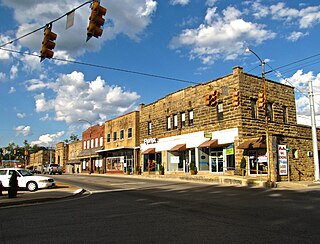
Kingston Street in Wartburg
There were 363 households, out of which 29.2% had children under the age of 18 living with them, 35.5% were married couples living together, 16.0% had a female householder with no husband present, and 45.7% were non-families. 43.3% of all households were made up of individuals, and 21.2% had someone living alone who was 65 years of age or older. The average household size was 2.12 and the average family size was 2.95.
In the city, the population was spread out, with 23.0% under the age of 18, 7.3% from 18 to 24, 21.6% from 25 to 44, 20.4% from 45 to 64, and 27.6% who were 65 years of age or older. The median age was 42 years. For every 100 females, there were 72.8 males. For every 100 females age 18 and over, there were 62.3 males.
The median income for a household in the city was $19,722, and the median income for a family was $37,917. Males had a median income of $32,708 versus $22,143 for females. The per capita income for the city was $12,252. About 24.5% of families and 29.8% of the population were below the poverty line, including 39.1% of those under age 18 and 19.1% of those age 65 or over.
White County is a county located in the U.S. state of Tennessee. As of the 2020 census, the population was 27,351. Its county seat is Sparta.
Roane County is a county of the U.S. state of Tennessee. As of the 2020 census, the population was 53,404. Its county seat is Kingston. Roane County is included in the Knoxville, TN Metropolitan Statistical Area.
Morgan County is a county located in the U.S. state of Tennessee. As of the 2020 census, the population was 21,035. Its county seat is Wartburg. Morgan County is part of the Knoxville, TN Combined Statistical Area.
Marion County is a county located in the U.S. state of Tennessee. As of the 2020 census, the population was 28,837. Its county seat is Jasper. Marion County is part of the Chattanooga, AL–TN–GA Metropolitan Statistical Area. Marion County is in the Central time zone, while Chattanooga proper is in the Eastern time zone.
Davidson County is a county in the U.S. state of Tennessee. It is located in the heart of Middle Tennessee. As of the 2020 census, the population was 715,884, making it the 2nd most populous county in Tennessee. Its county seat is Nashville, the state capital and most populous city.
Cumberland County is a county located in the U.S. state of Tennessee. As of the 2020 census, the population was 61,145. Its county seat is Crossville. Cumberland County comprises the Crossville, TN micropolitan statistical area.
Claiborne County is a county located in the U.S. state of Tennessee. As of the 2020 census, the population was 32,043. Its county seat is Tazewell and its largest city is Harrogate.
Burkesville is a home rule-class city in Cumberland County, Kentucky, in the United States. Nestled among the rolling foothills of Appalachia and bordered by the Cumberland River to the south and east, it is the seat of its county. The population was 1,521 at the 2010 census.
Grand Rivers is a home rule-class city in Livingston County, Kentucky, in the United States. The population was 382 at the 2010 census, up from 343 in 2000. It is part of the Paducah, KY-IL Metropolitan Statistical Area.
Dickinson Township is a township in Cumberland County, Pennsylvania, United States. The population was 5,223 at the 2010 census, up from 4,702 at the 2000 census.
Ashland City is a town and the county seat of Cheatham County, Tennessee. Located in Middle Tennessee, it is part of the Nashville-Davidson–Murfreesboro–Franklin, TN Metropolitan Statistical Area. As of the 2020 census, the town's population was 5,193.
Jamestown is a city in and the county seat of Fentress County, Tennessee, United States. The population of the city was 1,959 at the 2010 census.
Cowan is a city in Franklin County, Tennessee, United States. The population was 1,737 at the 2010 census. It is part of the Tullahoma, Tennessee Micropolitan Statistical Area.
Gruetli-Laager is a city in Grundy County, Tennessee, United States. The population was 1,813 at the 2010 census. As its name implies, Gruetli-Laager consists of two communities— Gruetli and Laager— incorporated as a single city.
Oakdale is a town located along the Emory River in Morgan County, Tennessee, United States. The population was 203 at the 2020 census, a decrease from the 2010 census figure of 212.
Sunbright is a city in Morgan County, Tennessee, United States. The population was 519 at the 2020 census.
Monterey is a town in Putnam County, Tennessee, United States. The population was 2,850 at the 2010 census. It is part of the Cookeville, Tennessee Micropolitan Statistical Area.
Huntsville is a town in Scott County, Tennessee, United States. The population was 1,270 at the 2020 census and 1,248 at the 2010 census. It is the county seat of Scott County.
Piedmont is a town in Mineral County, West Virginia, United States. It is part of the Cumberland, MD-WV metropolitan statistical area. The population was 716 at the 2020 census. Piedmont was chartered in 1856 and the town is the subject of Colored People: A Memoir by Piedmont native Henry Louis Gates Jr.
Harriman is a city located primarily in Roane County, Tennessee, with a small extension into Morgan County. The population of Harriman was 5,892 at the time of the 2020 census.
This page is based on this Wikipedia article Text is available under the CC BY-SA 4.0 license; additional terms may apply. Images, videos and audio are available under their respective licenses.