Smithville, Tennessee | |
---|---|
Coordinates: 35°57′26″N85°49′15″W / 35.95722°N 85.82083°W | |
Country | United States |
State | Tennessee |
County | DeKalb |
Founded | 1838 [1] |
Incorporated | 1843 [2] |
Named for | Samuel Granville Smith, local politician [1] |
Government | |
• Type | Mayor-Aldermanic |
Area | |
• Total | 5.85 sq mi (15.16 km2) |
• Land | 5.85 sq mi (15.16 km2) |
• Water | 0.00 sq mi (0.00 km2) |
Elevation | 1,037 ft (316 m) |
Population | |
• Total | 5,004 |
• Density | 854.80/sq mi (330.05/km2) |
Time zone | UTC-6 (Central (CST)) |
• Summer (DST) | UTC-5 (CDT) |
ZIP code | 37166 |
Area code | 615 |
FIPS code | 47-69320 [5] |
GNIS feature ID | 1313778 [6] |
Website | smithvillecityhall |
Smithville is a city in DeKalb County, Tennessee, United States. The population was 5,004 at the 2020 census, [7] up from 3,994 at the 2010 census. It is the county seat of DeKalb County. [8] Smithville is home to the Smithville Fiddler's Jamboree, which it has hosted annually since 1972. [9]
Smithville is located in central DeKalb County at 35°57′26″N85°49′15″W / 35.95722°N 85.82083°W (35.957191, -85.820756). [10] U.S. Route 70 passes through the town as Broad Street, leading east 21 miles (34 km) to Sparta and northwest 36 miles (58 km) to Lebanon. Tennessee State Route 56 (Congress Boulevard) crosses US 70 a few blocks southeast of the center of town and leads north 13 miles (21 km) to Interstate 40 at Silver Point and 19 miles (31 km) south to McMinnville. Cookeville is 28 miles (45 km) to the northeast, and Nashville is 65 miles (105 km) to the west.
According to the United States Census Bureau, the city has a total area of 5.9 square miles (15.3 km2), all land. [7]
Climate data for Smithville 2 SE, Tennessee (1991–2020 normals, extremes 1971–present) | |||||||||||||
---|---|---|---|---|---|---|---|---|---|---|---|---|---|
Month | Jan | Feb | Mar | Apr | May | Jun | Jul | Aug | Sep | Oct | Nov | Dec | Year |
Record high °F (°C) | 76 (24) | 78 (26) | 85 (29) | 90 (32) | 92 (33) | 105 (41) | 104 (40) | 102 (39) | 99 (37) | 95 (35) | 85 (29) | 76 (24) | 105 (41) |
Mean daily maximum °F (°C) | 47.2 (8.4) | 51.8 (11.0) | 60.3 (15.7) | 70.2 (21.2) | 77.9 (25.5) | 84.8 (29.3) | 87.7 (30.9) | 87.2 (30.7) | 81.8 (27.7) | 71.8 (22.1) | 60.0 (15.6) | 50.9 (10.5) | 69.3 (20.7) |
Daily mean °F (°C) | 36.4 (2.4) | 39.8 (4.3) | 47.4 (8.6) | 56.2 (13.4) | 65.2 (18.4) | 73.0 (22.8) | 76.6 (24.8) | 75.4 (24.1) | 69.0 (20.6) | 57.5 (14.2) | 46.7 (8.2) | 39.7 (4.3) | 56.9 (13.8) |
Mean daily minimum °F (°C) | 25.5 (−3.6) | 27.9 (−2.3) | 34.5 (1.4) | 42.3 (5.7) | 52.5 (11.4) | 61.3 (16.3) | 65.5 (18.6) | 63.6 (17.6) | 56.3 (13.5) | 43.3 (6.3) | 33.3 (0.7) | 28.4 (−2.0) | 44.5 (6.9) |
Record low °F (°C) | −24 (−31) | −17 (−27) | 0 (−18) | 18 (−8) | 27 (−3) | 38 (3) | 46 (8) | 44 (7) | 29 (−2) | 21 (−6) | 9 (−13) | −7 (−22) | −24 (−31) |
Average precipitation inches (mm) | 4.92 (125) | 5.07 (129) | 5.73 (146) | 4.99 (127) | 4.87 (124) | 5.14 (131) | 5.18 (132) | 3.92 (100) | 4.03 (102) | 3.28 (83) | 4.15 (105) | 5.69 (145) | 56.97 (1,447) |
Average snowfall inches (cm) | 1.1 (2.8) | 1.1 (2.8) | 0.3 (0.76) | 0.0 (0.0) | 0.0 (0.0) | 0.0 (0.0) | 0.0 (0.0) | 0.0 (0.0) | 0.0 (0.0) | 0.0 (0.0) | 0.0 (0.0) | 0.6 (1.5) | 3.1 (7.9) |
Average precipitation days (≥ 0.01 in) | 13.6 | 12.9 | 13.4 | 11.7 | 12.7 | 11.9 | 12.0 | 9.6 | 8.8 | 9.6 | 10.2 | 13.7 | 140.1 |
Average snowy days (≥ 0.1 in) | 0.9 | 0.9 | 0.3 | 0.0 | 0.0 | 0.0 | 0.0 | 0.0 | 0.0 | 0.0 | 0.0 | 0.6 | 2.7 |
Source: NOAA [11] [12] |
Census | Pop. | Note | %± |
---|---|---|---|
1890 | 572 | — | |
1920 | 687 | — | |
1930 | 886 | 29.0% | |
1940 | 919 | 3.7% | |
1950 | 1,558 | 69.5% | |
1960 | 2,348 | 50.7% | |
1970 | 2,997 | 27.6% | |
1980 | 3,839 | 28.1% | |
1990 | 3,791 | −1.3% | |
2000 | 3,994 | 5.4% | |
2010 | 4,530 | 13.4% | |
2020 | 5,004 | 10.5% | |
Sources: [13] [14] [4] |
Race | Number | Percentage |
---|---|---|
White (non-Hispanic) | 3,994 | 79.82% |
Black or African American (non-Hispanic) | 101 | 2.02% |
Native American | 11 | 0.22% |
Asian | 37 | 0.74% |
Pacific Islander | 5 | 0.1% |
Other/Mixed | 206 | 4.12% |
Hispanic or Latino | 650 | 12.99% |
As of the 2020 United States census, there were 5,004 people, 1,631 households, and 1,090 families residing in the city.
As of the census [5] of 2000, there were 3,994 people, 1,675 households, and 1,065 families residing in the city. The population density was 679.4 inhabitants per square mile (262.3/km2). There were 1,837 housing units at an average density of 312.5 per square mile (120.7/km2). The racial makeup of the city was 94.34% White, 2.73% African American, 0.15% Native American, 0.10% Asian, 1.65% from other races, and 1.03% from two or more races. Hispanic or Latino of any race were 4.06% of the population.
There were 1,675 households, out of which 27.9% had children under the age of 18 living with them, 43.0% were married couples living together, 16.9% had a female householder with no husband present, and 36.4% were non-families. 33.4% of all households were made up of individuals, and 15.1% had someone living alone who was 65 years of age or older. The average household size was 2.27 and the average family size was 2.85.
In the city, the population was spread out, with 22.9% under the age of 18, 8.9% from 18 to 24, 26.4% from 25 to 44, 22.3% from 45 to 64, and 19.6% who were 65 years of age or older. The median age was 38 years. For every 100 females, there were 83.2 males. For every 100 females age 18 and over, there were 78.0 males.
The median income for a household in the city was $22,482, and the median income for a family was $30,179. Males had a median income of $29,231 versus $20,705 for females. The per capita income for the city was $16,854. About 15.4% of families and 22.2% of the population were below the poverty line, including 28.3% of those under age 18 and 25.8% of those age 65 or over.
Smithville is referred to by a local-boy Marine talking to a girl and pointing to labels on a map during a dance hall scene, 17 minutes into the 1949 World War II John Wayne film, Sands of Iwo Jima , where it is mentioned, apart from everybody in his family being related to much of Tennessee, as being famous for "corn tobacco" and "more fertilizer than any other place in the world".
Smithville Fiddler's Jamboree & Crafts Festival | |
---|---|
Genre | Bluegrass music, old-time music |
Years active | 1972-present |
Attendance | 100,000+ |
Website | www |
Joe L. Evins helped start the world-famous Smithville Fiddler's Jamboree & Crafts Festival. The first Jamboree was held in July 1972 on a stage built on the steps of the DeKalb County Courthouse, and has been held there annually on the weekend nearest to July 4. The first Jamboree attracted 714 musicians from 16 states, and was attended by an estimated audience of 8,000. Present day audiences are estimated to be well over 100,000 from all over the U.S., and many from abroad. [16]
Calhoun County is a county in the east central part of the U.S. state of Alabama. As of the 2020 census, the population was 116,441. Its county seat is Anniston. It is named in honor of John C. Calhoun, a US Senator from South Carolina.
Warren County is a county located on the Cumberland Plateau in Middle Tennessee, one of the three Grand Divisions of the U.S. state of Tennessee. As of the 2020 census, the population was 40,953. Its county seat is McMinnville. Warren County comprises the McMinnville, TN Micropolitan Statistical Area.
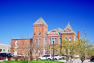
DeKalb County is a county located in the U.S. state of Tennessee. As of the 2020 census, the population was 20,080. Its county seat is Smithville. The county was created by the General Assembly of Tennessee on December 2, 1837, and was named for Revolutionary War hero Major General Johann de Kalb.
Walker County is a county located in the northwestern part of the U.S. state of Georgia. As of the 2020 census, the population was 67,654, down from 68,756 in 2010. The county seat is LaFayette. The county was created on December 18, 1833, from land formerly belonging to the Cherokee Indian Nation.
Henagar is a city in DeKalb County, Alabama, United States. At the 2020 census, the population was 2,292.
Lakeview is a town in DeKalb County, Alabama, United States. At the 2020 census, the population was 161. Lakeview is located atop Sand Mountain.
Powell is a town in DeKalb County, Alabama, United States. At the 2020 census, the population was 901. Powell is located atop Sand Mountain.
Rainsville is a city in DeKalb County, Alabama, United States. At the 2010 census the population was 4,948, up from 4,499 in 2000. Rainsville is located on top of Sand Mountain, a southern extension of the Cumberland Plateau.
Shiloh is a town in DeKalb County, Alabama, United States. It incorporated in 1962. At the 2020 census, the population was 321. Shiloh is located atop Sand Mountain.
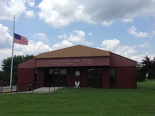
Smithville is a town in Lawrence County, Arkansas, United States. The population was 78 at the 2010 census.
Fort Oglethorpe is a city predominantly in Catoosa County with some portions in Walker County in the U.S. state of Georgia. As of the 2020 census, the city had a population of 10,423. It is part of the Chattanooga, TN–GA Metropolitan Statistical Area. It is home to Lakeview – Fort Oglethorpe High School.
Trenton is a city and the only incorporated municipality in Dade County, Georgia, United States—and as such, it serves as the county seat. The population was 2,195 at the 2020 census. Trenton is part of the Chattanooga, Tennessee–GA Metropolitan Statistical Area.
Smithville is a city in Clay and Platte counties in the U.S. state of Missouri and is part of the Kansas City metropolitan area, along the Little Platte River. The population was 10,406 at the 2020 United States Census.
Maysville is a city in DeKalb County, Missouri, United States. The population was 1,095 at the 2020 census. Maysville is the county seat of DeKalb County.
Alexandria is a town in DeKalb County, Tennessee, United States. The population was 966 at the 2010 census.
Liberty is a town in DeKalb County, Tennessee, United States. The population was 367 at the 2000 census and 310 in 2010. Liberty's main street was listed on the National Register of Historic Places in 1987 as the Liberty Historic District.
Elkton is a city in Giles County, Tennessee, United States. The population was 578 at the 2010 census.
Sparta is a city in and the county seat of White County, Tennessee, United States. The population was 5,001 in 2020.
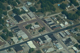
Smithville is a city in Bastrop County, Texas, United States, near the Colorado River. The population was 3,922 at the 2020 census.
Smithville is an unincorporated community and census-designated place (CDP) located within Galloway Township, in Atlantic County, in the U.S. state of New Jersey, that was established as part of the 2010 United States Census. Smithville is located 15 miles (24 km) north of and inland from Atlantic City. As of the 2010 Census, the CDP's population was 7,242.