Fort McDermitt Paiute and Shoshone Tribe

Last updated

Fort McDermitt Northern Paiute and Western Shoshone Tribes
Sarah-winnemucca.jpg
Sarah Winnemucca, a Northern Paiute activist and author, worked as an interpreter, scout and hospital matron at Fort McDermit from 1868 to 1873. [1]
Total population
689 enrolled members (1992) [2]
341 residents on reservation (2010) [3]
Regions with significant populations
Flag of the United States.svg  United States
(Flag of Nevada.svg  Nevada, Flag of Oregon.svg  Oregon)
Languages
Northern Paiute language, English [4]
Religion
Christianity, Sun Dance, [5] Native American Church, Traditional Unity Movement [6]
Related ethnic groups
Southern Paiute and Western Shoshone peoples

The Fort McDermitt Paiute and Shoshone Tribe is a federally recognized tribe of Northern Paiute and Western Shoshone peoples, whose reservation Fort McDermitt Paiute and Shoshone Tribes of the Fort McDermitt Indian Reservation spans the Nevada and Oregon border next to Idaho. [7] The reservation has 16,354 acres (6,618 ha) in Nevada and 19,000 acres (7,700 ha) in Oregon.

Contents

Peoples from these two tribes have historically also lived in what is now defined as southwestern Idaho. They are close culturally and linguistically to the Bannock people and various other Shoshone-language peoples. Peoples of these tribes are members of other federally recognized tribes in Nevada and Idaho.

In October 2016 a federal law was passed to put approximately 19,094 acres of Bureau of Land Management (BLM) land into trust for the Tribe in order to expand their reservation; this was done under the Nevada Native Nations Land Act. Gambling is prohibited on the new lands. [8]

Reservation

Location of Fort McDermitt Indian Reservation 1210R Fort McDermitt Indian Reservation Locator Map.svg
Location of Fort McDermitt Indian Reservation

The Fort McDermitt Indian Reservation spans the distance of the Nevada–Oregon border, in Humboldt County, Nevada and Malheur County, Oregon, [9] near the Quinn River, which runs east to west through the Tribe's Nevada lands. Just to the east is southwestern Idaho. The Fort McDermitt Military Reservation was established 14 August 1865 at the former site of Quinn River Camp No. 33 and a stagecoach stop, Quinn River Station, in what was a traditional seasonal homeland of the Paiute, Shoshone and Bannock peoples.

The reservation was established with 16,354 acres (66.2 km2) in Nevada and 19,000 acres (76.9 km2) in Oregon, mostly areas of arid land. In October 2016 the federal government put into trust for the tribe approximately 19,094 acres (77.3 km2) acres of Bureau of Land Management (BLM) land in Nevada, in order to expand their reservation and give them a more sustainable base. Gaming is prohibited on these new lands. This was done under the Nevada Native Nations Land Act (PL No: 114-232). [8]

History

Originally the fort was established to protect the stagecoach route from Virginia City through Winnemucca, Nevada to Silver City, Idaho Territory, in the southwestern part of the area. It was named after Lt. Col. Charles McDermit, commander of the Military District of Nevada, who was killed in a skirmish in the area in 1865. [10] [11]

The Paiute had traditional territory ranging from the Southwest up into Nevada, Oregon and southwestern Idaho. The Paiute in this area became known as the "Northern Paiute." They are related culturally and linguistically to the Shoshone, Bannock and other tribes of the region.

When the military outpost was closed in 1889, the Military Reservation was adapted as the Fort McDermitt Indian Agency. Northern Paiute and Shoshone were settled here. In 1936 the federal government established an Indian reservation to support the tribe's organizing as the Paiute and Shoshone Tribe under the Indian Reorganization Act of 1934. [12] [13] They had to give up their traditional, hereditary chiefs as leaders in favor of an elected, representative form of government.

Government

The Tribes drafted a Constitution and Bylaws (which were approved after changes by the US Bureau of Indian Affairs). It also had a Corporate Charter (drafted by the federal government and containing provisions not required by the Indian Reorganization Act of 1934.) On 6 May 1936 the new Constitution, ByLaws and Corporate Charter was approved by 54 of 65 available voters.

The government has an elected chairman and an elected eight-member Tribal Council, including a vice chairman. [2]

As at the 2010 census, 313 Native Americans lived on the reservation, with 42 enrolled members living in nearby McDermitt, Oregon. [14] [9] More tribal members than "enrolled" tribal members live on the Reservation. The Tribe's Constitution and laws have some conflicting definitions of tribal members.

The Constitution defines tribal members as:

The Constitution and ByLaws allow the Tribal Council to enroll two classes of People; see id., Article II, Section 2(a),(b). The confusion was created in the 1980s. At a time when Northern Paiute land claims funds were about to be disbursed, federal officials suggested that the Tribal Council enact an "Enrollment Ordinance" to define membership qualifications of the Tribe and noted that only the council had authority to do this. The ordinance did not address conflicts with standing definitions of members, as noted above (and in Article II, Section 1(a) and (b)).

Language

The tribe speaks the Northern Paiute language, also known as Paviotso, which is a Western Numic language. Fort McDermitt has the greatest concentration of Northern Paiute speakers among the various locations where they live. 20–30% of the tribe's children can speak the language. [4]

Communities

Notable tribal members and residents

Related Research Articles

<span class="mw-page-title-main">Humboldt County, Nevada</span> County in Nevada, United States

Humboldt County is a county in the U.S. state of Nevada. As of the 2020 Census, the population was 17,285. It is a largely rural county that is sparsely populated with the only major city being Winnemucca which has a population of 8,431. Humboldt County comprises the Winnemucca, NV Micropolitan Statistical Area and serves as an important crossroads in the national transportation network. Interstate 80 travels through the southeastern corner of the county, meeting US 95 in Winnemucca that serves as a primary freight corridor between Northern Nevada and Boise, Idaho and the Interstate 84 freight corridor that links much of the Pacific Northwest. The original transcontinental railway, constructed by the Central Pacific Railroad, reached Humboldt County on Sept. 16, 1868. The Western Pacific Railroad would reach Humboldt County by November 1909, providing two mainline rail links to California and the Eastern United States. Both railroads have since been acquired by the Union Pacific Railroad, who continues to serve the region today.

<span class="mw-page-title-main">Owyhee, Nevada</span> Census-designated place in Nevada, United States

Owyhee is a census-designated place (CDP) in Elko County, Nevada, United States, along the banks of the Owyhee River. The population was 953 at the 2010 census. It is part of the Elko Micropolitan Statistical Area. It is the primary town of the federally recognized Shoshone-Paiute tribe's Duck Valley Indian Reservation, which covers portions of northern Nevada and southern Idaho, and the majority of its population are Native American.

<span class="mw-page-title-main">McDermitt, Nevada and Oregon</span> Unincorporated community in the state of Nevada, United States

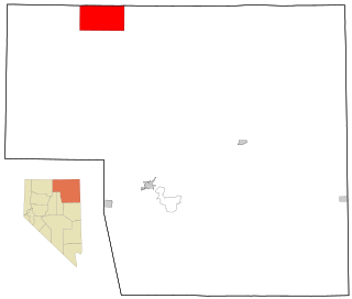
McDermitt is an unincorporated community straddling the Nevada–Oregon border, in Humboldt County, Nevada, and Malheur County, Oregon, United States. McDermitt's economy has historically been based on mining, ranching, and farming. The last mining operation closed in 1990, resulting in a steady decline in population.

<span class="mw-page-title-main">Sarah Winnemucca</span> Northern Paiute author, activist, and educator (c. 1844 –1891)

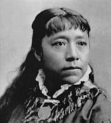
Sarah Hopkins was a Northern Paiute writer, activist, lecturer, teacher, and school organizer. Her Northern Paiute name was Thocmentony, also spelled Tocmetone, which translates as "Shell Flower."

<span class="mw-page-title-main">Northern Paiute people</span> Native American tribe in eastern California

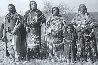
The Northern Paiute people are a Numic tribe that has traditionally lived in the Great Basin region of the United States in what is now eastern California, western Nevada, and southeast Oregon. The Northern Paiutes' pre-contact lifestyle was well adapted to the harsh desert environment in which they lived. Each tribe or band occupied a specific territory, generally centered on a lake or wetland that supplied fish and waterfowl. Communal hunt drives, which often involved neighboring bands, would take rabbits and pronghorn from surrounding areas. Individuals and families appear to have moved freely among the bands.

The Shoshone or Shoshoni are a Native American tribe with four large cultural/linguistic divisions:

The Bannock War of 1878 was an armed conflict between the U.S. military and Bannock and Paiute warriors in Idaho and northeastern Oregon from June to August 1878. The Bannock totaled about 600 to 800 in 1870 because of other Shoshone peoples being included with Bannock numbers. they were led by Chief Buffalo Horn, who was killed in action on June 8, 1878. After his death, Chief Egan led the Bannocks. He and some of his warriors were killed in July by a Umatilla party that entered his camp in subterfuge.

<span class="mw-page-title-main">Bannock people</span> Indigenous people of North America

The Bannock tribe were originally Northern Paiute but are more culturally affiliated with the Northern Shoshone. They are in the Great Basin classification of Indigenous People. Their traditional lands include northern Nevada, southeastern Oregon, southern Idaho, and western Wyoming. Today they are enrolled in the federally recognized Shoshone-Bannock Tribes of the Fort Hall Reservation of Idaho, located on the Fort Hall Indian Reservation.

<span class="mw-page-title-main">Western Shoshone</span> Grouping of Shoshone tribes in the Great Basin

Western Shoshone comprise several Shoshone tribes that are indigenous to the Great Basin and have lands identified in the Treaty of Ruby Valley 1863. They resided in Idaho, Nevada, California, and Utah. The tribes are very closely related culturally to the Paiute, Goshute, Bannock, Ute, and Timbisha tribes.

<span class="mw-page-title-main">Winnemucca (Paiute leader)</span> Native American Northern Paiute war chief (c. 1820–1882)

Winnemucca was a Northern Paiute war chief. He was born a Shoshone around 1820 in what would later become the Oregon Territory.

<span class="mw-page-title-main">Duck Valley Indian Reservation</span> Indian reservation in United States, Shoshone-Paiute

The Duck Valley Indian Reservation was established in the 19th century for the federally recognized Shoshone-Paiute Tribe. It is isolated in the high desert of the western United States, and lies on the state line, the 42nd parallel, between Idaho and Nevada.

<span class="mw-page-title-main">Malheur Indian Reservation</span>

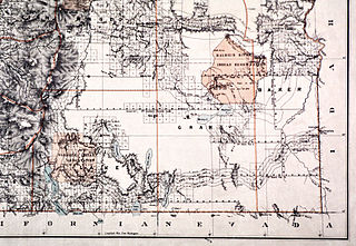
The Malheur Indian Reservation was an American Indian reservation established for the Northern Paiute in eastern Oregon and northern Nevada from 1872 to 1879. The federal government discontinued the reservation after the Bannock War of 1878, under pressure from European-American settlers who wanted the land. This negative recommendation against continuing by its agent William V. Rinehart, led to the internment of more than 500 Paiute on the Yakama Indian Reservation, as well as the reluctance of the Bannock and Paiute to return to the lands after the war.

<span class="mw-page-title-main">Fort McDermit</span>

Fort McDermit was a U.S. Army fort in Nevada. It was established on August 14, 1865, by Captain J. C. Doughty, of Company I of the 2nd Regiment California Volunteer Cavalry, on orders of Lt. Col. Charles McDermit, Commander, Military District Nevada, as Quinn River Camp No. 33. It was located near Quinn River Station on the East Fork of the Quinn River.

The Lovelock Paiute Tribe of the Lovelock Indian Colony is a federally recognized tribe of Northern Paiute Indians in Pershing County, Nevada.

<span class="mw-page-title-main">Summit Lake Paiute Tribe of Nevada</span>

The Summit Lake Paiute Tribe of Nevada is a federally recognized tribe of Northern Paiute Indians in northwest Nevada. Their autonym in their language is Agai Panina Ticutta, meaning "Fish Lake Eaters." They are traditionally known as the "Fish Eaters."

<span class="mw-page-title-main">Winnemucca Indian Colony of Nevada</span> Indian reservation in the United States

The Winnemucca Indian Colony of Nevada is a federally recognized tribe of Western Shoshone and Northern Paiute Indians in northwestern Nevada.

Fort McDermitt is a census-designated place (CDP) in Humboldt County, Nevada, United States. The population was 341 at the 2010 census. It overlaps the Fort McDermitt Indian Reservation and lies just south of the McDermitt CDP.

References

  1. Canfield, Gae Whitney (1988). Sarah Winnemucca of the Northern Paiutes. Norman, OK: University of Oklahoma Press. pp. 55–76. ISBN   9780806120904.
  2. 1 2 Pritzker 226
  3. "2010 Census Data". U.S. Census Bureau. Archived from the original on 13 October 2013. Retrieved 24 August 2011.
  4. 1 2 "Paiute, Northern.", Ethnologue, Retrieved 2 June 2013.
  5. Pritzker 227
  6. Pritzker 223
  7. "Tribal Directory." National Congress of American Indians. Retrieved 2 June 2013.
  8. 1 2 "Nevada Native Nations Land Act" Archived 1 December 2016 at the Wayback Machine , Propublica website; accessed 30 November 2016
  9. 1 2 Pritzker 241
  10. McArthur, Lewis A.; McArthur, Lewis L. (2003) [1928]. Oregon Geographic Names (7th ed.). Portland, Oregon: Oregon Historical Society Press. p. 624. ISBN   978-0875952772.
  11. "McDermit, Charles". Carson City Consolidated Municipality. Archived from the original on 27 September 2011. Retrieved 25 August 2011.
  12. "Winnemucca to Silver City Wagon Road". Bureau of Land Management. Retrieved 26 August 2011.
  13. 1 2 Johnston, Charlie. "Reservations & Colonies" Archived 10 June 2013 at the Wayback Machine , Nevada Magazine, July/August 2011; Retrieved 2 June 2013.
  14. "2010 Census Data". U.S. Census Bureau. Archived from the original on 13 October 2013. Retrieved 24 August 2011.

Further reading

41°55.184′N117°42.485′W / 41.919733°N 117.708083°W / 41.919733; -117.708083