Louisville is the most populous city in the Commonwealth of Kentucky, sixth-most populous city in the Southeast, and the 27th-most-populous city in the United States. By land area, it is the country's 24th-largest city. Louisville is the historical seat and, since 2003, the nominal seat of Jefferson County, on the Indiana border.

Clarksville is a town in Clark County, Indiana, United States, along the Ohio River and is a part of the Louisville Metropolitan area. The population was 22,333 at the 2020 census. The town was founded in 1783 by early resident George Rogers Clark at the only seasonal rapids on the entire Ohio River, it is the oldest American town in the former Northwest Territory. The town is home to the Colgate clock, one of the largest clocks in the world and the Falls of the Ohio State Park, home to the world's largest exposed Devonian period fossil bed.

St. Matthews is a city in Jefferson County, Kentucky, United States. It forms part of the Louisville Metro government but is separately incorporated as a home rule-class city. The population was 17,472 at the 2010 census, up from 15,852 at the 2000 census. It is the 23rd-largest city in the state. St. Matthews is one of the state's major shopping areas, home to the fifth-largest mall in Kentucky along with many smaller shopping centers along Shelbyville Road.

George Rogers Clark was an American military officer and surveyor from Virginia who became the highest-ranking Patriot military officer on the northwestern frontier during the Revolutionary War. He served as leader of the Virginia militia in Kentucky throughout much of the war. He is best known for his captures of Kaskaskia in 1778 and Vincennes in 1779 during the Illinois campaign, which greatly weakened British influence in the Northwest Territory and earned Clark the nickname of "Conqueror of the Old Northwest". The British ceded the entire Northwest Territory to the United States in the 1783 Treaty of Paris.

The Original Highlands is a historic neighborhood in the Highlands area of Louisville, Kentucky, United States.

Portland is a neighborhood and former independent town northwest of downtown Louisville, Kentucky. It is situated along a bend of the Ohio River just below the Falls of the Ohio, where the river curves to the north and then to the south, thus placing Portland at the northern tip of urban Louisville. In its early days it was the largest of the six major settlements at the falls, the others being Shippingport and Louisville in Kentucky and New Albany, Clarksville, and Jeffersonville on the Indiana side. Its modern boundaries are the Ohio River along the northwest, north, and northeast, 10th Street at the far east, Market Street on the south, and the Shawnee Golf Course at the far west.
Downtown Louisville is the largest central business district in the Commonwealth of Kentucky and the urban hub of the Louisville, Kentucky Metropolitan Area. Its boundaries are the Ohio River to the north, Hancock Street to the east, York and Jacob Streets to the south, and 9th Street to the west. As of 2015, the population of downtown Louisville was 4,700, although this does not include directly surrounding areas such as Old Louisville, Butchertown, NuLu, and Phoenix Hill.

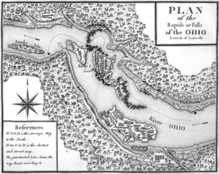
The history of Louisville, Kentucky spans nearly two-and-a-half centuries since its founding in the late 18th century. The geology of the Ohio River, with but a single series of rapids midway in its length from the confluence of the Monongahela and Allegheny rivers to its union with the Mississippi, made it inevitable that a town would grow on the site. The town of Louisville, Kentucky was chartered there in 1780. From its early days on the frontier, it quickly grew to be a major trading and distribution center in the mid-19th century and an important industrial city in the early 20th. The city declined in the mid-20th century, but by the late 20th, it was revitalized as a culturally-focused mid-sized American city.

The Chenoweth Massacre of July 17, 1789 was the last major Native American raid in present-day Louisville, Kentucky.
Audubon is a neighborhood in Louisville, Kentucky, United States. Its boundaries are Clarks Lane to the north, Poplar Level Road to the east, Preston Highway to the west, and the city of Audubon Park to the south. The smaller city of Parkway Village is surrounded by Audubon. George Rogers Clark Park, the site of a cabin owned by the parents of George Rogers Clark, is a prominent feature of the neighborhood.
The Point was a thriving 19th century neighborhood in Louisville, Kentucky, east of Downtown Louisville and opposite Towhead Island along the Ohio River. It was also located north of the present day Butchertown area.

During the 18th and early 19th centuries, the French, British and U.S. forces built and occupied a number of forts at Vincennes, Indiana. These outposts commanded a strategic position on the Wabash River. The names of the installations were changed by the various ruling parties, and the forts were considered strategic in the French and Indian War, the American Revolutionary War, the Northwest Indian War and the War of 1812. The last fort was abandoned in 1816.

The Fourteenth Street Bridge, also known as the Ohio Falls Bridge, Pennsylvania Railroad Bridge, Conrail Railroad Bridge or Louisville and Indiana (L&I) Bridge, is a truss drawbridge that spans the Ohio River, between Louisville, Kentucky and Clarksville, Indiana.
Shippingport, Kentucky is an industrial site and one of the six formerly independent settlements at the Falls of the Ohio in what is now Louisville, Kentucky. It was located on a peninsula on the south bank of the Ohio River, and incorporated without a name on October 10, 1785. It was later named Campbell Town after Revolutionary War soldier and settler John Campbell. He had been granted the land for his earlier service in the French & Indian War.

James John Floyd (1750–1783) was an early settler of St. Matthews, Kentucky, and helped lay out Louisville. In Kentucky he served as a Colonel of the Kentucky Militia in which he participated in raids with George Rogers Clark and later became one of the first judges of Kentucky.
Captain Isaac Ruddell was an 18th-century American Virginia State Line officer during the American Revolutionary War and a Kentucky frontiersman. He was an officer commanding a company under BGEN George Rogers Clark (1777–1782). He was the founder of Ruddell's Station, or fort, on the Licking River in present-day Harrison County, Kentucky. In 1780, during the Revolutionary War, the settlement was destroyed by joint British Canadian and Eastern Woodlands Indian forces under British officer Captain Henry Bird. He and his family were held prisoner in Detroit for over two years before their release.

Low Dutch Station was established in 1780 on the middle fork of Beargrass Creek in Kentucky. This station was settled by Dutch pioneers from Pennsylvania and was also known as New Holland Station. The station was one of a group of seven forts established on Beargrass Creek during this period in this area that is now a part of Louisville. The leader of the group was Hendrick Banta. The group of settlers were a part of the "Low Dutch Company" and had their own bylaws, a formal charter, and accounting procedures. The group had as its purpose the preservation of the language, culture and religion of the Dutch. The Dutch traveled from a settlement near Harrodsburg to Low Dutch Station.
Floyd's Station was a fort on Beargrass Creek in what is now St. Matthews, Kentucky. In November 1779 James John Floyd built cabins and a stockade near what is now Breckenridge Lane. In 1783, John Floyd, future Governor of Virginia was born in the Station. The pioneer's father was killed by Indians twelve days before the birth of his son. The station was one of six on Beargrass Creek and was involved in local conflict with Native Americans in the area for the next five years. All that remain today of Floyd's Station are a spring house and cemetery.