Fort Salonga

Last updated
Fort Salonga
Nearest city Fort Salonga, New York
Area0.2 acres (0.081 ha)
Built1776
NRHP reference # 82003406 [1]
Added to NRHPMay 21, 1982

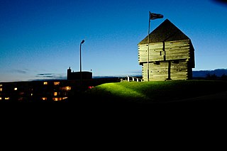
Fort Salonga, also known as NYSDHP Unique Site No. A103-08-0036, is an archeological site in the vicinity of Fort Salonga, New York that was listed on the National Register of Historic Places in 1982. [1]

Fort Salonga, New York Hamlet and census-designated place in New York, United States

Fort Salonga is a hamlet and census-designated place (CDP) in Suffolk County, New York on the North Shore of Long Island. At the 2010 census, the CDP population was 10,008. The name evolved from the Revolutionary War-era British Fort Salonga, or Fort Slongo, once located near the border of the towns of Huntington and Smithtown, overlooking Long Island Sound.

It is the site of the Revolutionary War British Fort Salonga, or Fort Slongo, (named after one of the fort's architects – George Slongo [2] ) once located near the border of Huntington Township and The Town of Smithtown, overlooking the Long Island Sound.

Huntington, New York Town in New York, United States

The Town of Huntington is one of ten towns in Suffolk County, New York, United States. Founded in 1653, it is located on the north shore of Long Island in northwestern Suffolk County, with Long Island Sound to its north and Nassau County adjacent to the west. Huntington is part of the New York metropolitan area. As of the United States 2010 Census, the town population was 203,264.

Smithtown, New York Town in New York, United States

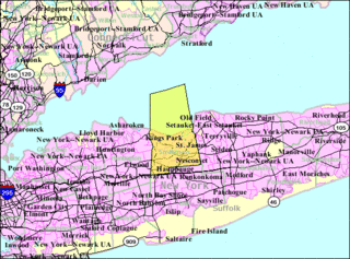
Smithtown is a town in Suffolk County, New York, United States, on the North Shore of Long Island. This town is an eastern suburb of New York City. The population was 117,801 at the 2010 Census.

Long Island Sound A tidal estuary on the east coast of the United States

Long Island Sound is a tidal estuary of the Atlantic Ocean, lying predominantly between the U.S. state of Connecticut to the north, and Long Island in New York to the south. From west to east, the sound stretches 110 miles (177 km) from the East River in New York City, along the North Shore of Long Island, to Block Island Sound. A mix of freshwater from tributaries and saltwater from the ocean, Long Island Sound is 21 miles (34 km) at its widest point and varies in depth from 65 to 230 feet.

A historic plaque near the site Battle of Fort Slongo HM-EB NY 25A.jpg
A historic plaque near the site

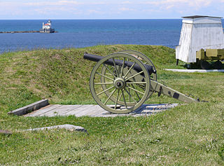
In an October 1781 skirmish between the British and Americans at the fort, Elijah Churchill, a soldier for the Continental Army, was wounded. He personally received a Badge of Military Merit from George Washington for his actions. The Badge became the Purple Heart and he is credited with being the first to receive the award. [3]

Elijah Churchill (1755–1841), was a soldier for the Continental Army during the American Revolutionary War.

Continental Army Colonial army during the American Revolutionary War

The Continental Army was formed by the Second Continental Congress after the outbreak of the American Revolutionary War by the ex-British colonies that became the United States of America. Established by a resolution of the Congress on June 14, 1775, it was created to coordinate the military efforts of the Thirteen Colonies in their revolt against the rule of Great Britain. The Continental Army was supplemented by local militias and volunteer troops that remained under control of the individual states or were otherwise independent. General George Washington was the commander-in-chief of the army throughout the war.

Badge of Military Merit

The Badge of Military Merit was a military award of the United States Armed Forces. It is largely considered America's first military decoration, and the second oldest in the world. The award was only given to non-commissioned officers and privates. The Purple Heart is the official successor decoration of the Badge of Military Merit.

Related Research Articles

Fort McHenry United States fort

Fort McHenry is a historical American coastal pentagonal bastion fort located in the Locust Point neighborhood of Baltimore, Maryland. It is best known for its role in the War of 1812, when it successfully defended Baltimore Harbor from an attack by the British navy from the Chesapeake Bay on September 13–14, 1814. It was first built in 1798 and was used continuously by the U.S. armed forces through World War I and by the Coast Guard in World War II. It was designated a national park in 1925, and in 1939 was redesignated a "National Monument and Historic Shrine".

Niagara-on-the-Lake Town in Ontario, Canada

Niagara-on-the-Lake is a town in Ontario, Canada. It is located on the Niagara Peninsula at the point where the Niagara River meets Lake Ontario, across the river from New York, United States. Niagara-on-the-Lake is in the Niagara Region of Ontario, and is the only town in Canada that has a Lord Mayor. It has a population of 17,511 (2016).

Fort Niagara United States historic place

Fort Niagara is a fortification originally built to protect the interests of New France in North America. It is located near Youngstown, New York, on the eastern bank of the Niagara River at its mouth, on Lake Ontario.

National Historic Sites of Canada site of national historic significance in Canada

National Historic Sites of Canada are places that have been designated by the federal Minister of the Environment on the advice of the Historic Sites and Monuments Board of Canada (HSMBC), as being of national historic significance. Parks Canada, a federal agency, manages the National Historic Sites program. As of August 2019, there were 996 National Historic Sites, 172 of which are administered by Parks Canada; the remainder are administered or owned by other levels of government or private entities. The sites are located across all ten provinces and three territories, with two sites located in France.

Battle of Beaver Dams War of 1812 battle

The Battle of Beaver Dams took place on 24 June 1813, during the War of 1812. An American column marched from Fort George and attempted to surprise a British outpost at Beaver Dams, billeting themselves overnight in the village of Queenston, Ontario. Laura Secord, a resident of Queenston, had earlier learned of the American plans, and had struck out on a long and difficult trek to warn the British at Decou's stone house near present-day Brock University. When the Americans resumed their march, they were ambushed by Native warriors and eventually surrendered to a small British detachment led by Lieutenant James FitzGibbon. About 500 Americans, including their wounded commander, were taken prisoner.

Fort Ontario United States historic place

Fort Ontario is an American historic fort situated by the City of Oswego in Oswego County, New York. It is owned by the state of New York and operated as a museum known as Fort Ontario State Historic Site.

Fort Frederica National Monument United States historic place

Fort Frederica National Monument, on St. Simons Island, Georgia, preserves the archaeological remnants of a fort and town built by James Oglethorpe between 1736 and 1748 to protect the southern boundary of the British colony of Georgia from Spanish raids. About 630 British troops were stationed at the fort.

San Marcos de Apalache Historic State Park United States historic place

San Marcos de Apalache Historic State Park is a Florida State Park in Wakulla County, Florida organized around the historic site of a Spanish colonial fort, which was used by succeeding nations that controlled the area. The Spanish first built wooden buildings and a stockade in the late 17th and early 18th centuries here, which were destroyed by a hurricane.

Fort Necessity National Battlefield United States historic place

Fort Necessity National Battlefield is a National Battlefield Site in Fayette County, Pennsylvania, United States, which preserves the site of the Battle of Fort Necessity. The battle, which took place on July 3, 1754, was an early battle of the French and Indian War, and resulted in the surrender of British colonial forces under Colonel George Washington, to the French and Indians, under Louis Coulon de Villiers.

Ninety Six National Historic Site United States historic place

Ninety Six National Historic Site, also known as Old Ninety Six and Star Fort, is a United States National Historic Site located about 60 miles south of Greenville, South Carolina. The historic site was listed on the National Register in 1969, declared to be a National Historic Landmark in 1973, and established as a National Historic Site in 1976 to preserve the original site of Ninety Six, South Carolina, a small town established in the early 18th century. It encompasses 1,022 acres of property.

Fisgard Lighthouse National Historic Site lighthouse in British Columbia, Canada

Fisgard Lighthouse National Historic Site, on Fisgard Island at the mouth of Esquimalt Harbour in Colwood, British Columbia, is the site of Fisgard Lighthouse, the first lighthouse on the west coast of Canada.

Fort Durham United States historic place

Fort Durham, also known as Fort Taku, Taku, Taco, and Tacouw, is an archaeological site near Taku Harbor, Alaska, within the limits of Juneau City and Borough and Tongass National Forest. It was one of three Hudson's Bay Company (HBC) posts set up in Russian America. The Fort Durham Site was declared a U.S. National Historic Landmark in 1978.

United States Post Office (Northport, New York) United States historic place

Northport Post Office, the U.S. post office in Northport, New York, is located at 244 Main Street in Northport, New York. It serves the ZIP code 11768, which also includes Asharoken, Eaton's Neck, Vernon Valley, Middleville, and Fort Salonga.

Fort Golgotha and the Old Burial Hill Cemetery United States historic place

Fort Golgotha and the Old Burial Hill Cemetery is the site of an historic cemetery, officially known as the "Old Burying Ground", and the location of a former Revolutionary War-era fort, known as Fort Golgotha, at Main Street and Nassau Road in Huntington, New York. It is located in the Old Town Green Historic District and Old Town Hall Historic District.

Fort Morris Historic Site United States historic place

Fort Morris Historic Site is a Georgia state historic park in Liberty County, Georgia in the United States. The fort is on a bend in the Medway River and played an important role in the protection of southeast Georgia throughout various conflicts beginning in 1741 and ending in 1865 at the conclusion of the American Civil War, including the French and Indian and American Revolutionary Wars and War of 1812. The historic site is 70 acres (28 ha) and sits at an elevation of 23 feet (7.0 m).

Battle of Fort Slongo

The Battle of Fort Slongo was fought on October 3, 1781 between American Continental Army forces, under the command of Benjamin Tallmadge, and the British defenders of Fort Salonga, in the American Revolutionary War. The fort was located near the border of present-day Huntington Township and Smithtown, New York, overlooking Long Island Sound.

References

  1. 1 2 "National Register Information System". National Register of Historic Places . National Park Service. 2010-07-09.
  2. http://northporthistorical.org/documents/Brief_History.pdf
  3. "Archived copy". Archived from the original on 2009-04-24. Retrieved 2010-11-12.CS1 maint: archived copy as title (link)