
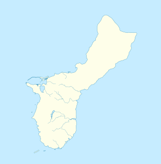
Hagåtña is the capital village of the United States territory of Guam. From the 18th through mid-20th century, it was Guam's population center, but today it is the second smallest of the island's 19 villages in both area and population. However, it remains one of the island's major commercial districts in addition to being the seat of government.

Humåtak is a village on the southwestern coast of the United States territory of Guam. The month of March in the Chamorro language is "Umatalaf," or "to catch guatafi," which is believed to be the root word of Umatac. The village's population has decreased since the island's 2000 census, and it is by far the least populated village on the island.

The San Dionisio Church Ruins are a historic ruins on Route 2 in Umatac, Guam. They are the remains of a church that was built in 1862 and destroyed by an earthquake in 1892. It was built out of manposteria, and the surviving elements including buttresses rising to a height of 13 feet (4.0 m). The ruins are the only surviving remnant of the Spanish colonial headquarters complex that stood in this area. The first San Dionisio Church was constructed in 1681, but rebuilt after a fire three years later. That church was destroyed in 1849 by an earthquake, and portions may have been used in construction of the 1862 building. A new church was built in 1939. The ruins were added to the National Register of Historic Places in 1974.

Fort Nuestra Señora de la Soledad is a fortification near Umatac, Guam. Built by the Spanish probably between 1802 and 1819, it was the fourth of four fortifications that protected an anchorage for galleons transiting between Acapulco, Mexico and the Philippines, a route that fell out of use in 1815 with Mexican independence.
The Guam Congress Building, also known as the Guam Legislature Building, is the seat of the Legislature of Guam and is located in Chalan Santo Papa in Hagåtña, Guam. It was built in 1949 by Pacific Island Buildings and of Brown & Root Pacific Bridge & Maxon. It has served as a capitol and as a courthouse building. It is a Modern Movement-style building that was listed on the U.S. National Register of Historic Places in 2007.

The Umatac Outdoor Library, located on Guam Highway 4 in Umatac, Guam, was built in 1933 by Francisco Quinata Sanchez and Umatac villagers. It was listed on the National Register of Historic Places in 1999.

Cetti Bay is an oceanic bay and historic site near Umatac, Guam, that is listed on the National Register of Historic Places.

Fort Santa Agueda, on Guam Highway 7 in Hagåtña, Guam, dates from about 1800, during the 1784-1802 administration of Spanish governor Manuel Moro. It was an uncovered fort with a manposteria parapet, rising about 10 feet (3.0 m) above a sloping hillside. It is listed on the U.S. National Register of Historic Places, as the only remaining fortification of the Spanish Era in Hagåtña.
The Spanish Fort in Colonia, the capital of Yap State in the Federated States of Micronesia, is a historic seat of power on the island of Yap. Only foundational remnants of the 19th-century Spanish fortification survive, on a property now occupied by the local government. The site was also where German and Japanese administrators had their headquarters during their respective periods of administration in the decades of the 20th century before World War II. The foundation was built of stone and cement, and is still accessible via its original steps.
The Spanish Wall is the deteriorating remnant of Spanish Fort Alphonso XIII in Kolonia, the capital of Pohnpei State in the Federated States of Micronesia. When built, the wall was about 0.5 miles (0.80 km) in length and 8 feet (2.4 m) in height with a parapet that ranged in height from 2–3 feet (0.61–0.91 m). The wall was built by Spanish administrators of Pohnpei in 1887 after a local uprising drove the local Spanish authorities onto a ship in the harbor. Most of the wall was taken down by the German administration that took over in the early 20th century, after the Spanish–American War. The remains of the wall, about 700 feet (210 m) and two arches, are now part of a local park.

The Agat World War II Amtrac is an underwater relic of World War II, located off Ga'an Point in Agat Bay on the west side of the island of Guam. It is the remains of an LVT 4, an amphibious tracked landing vehicle. It is located about 500 yards (460 m) off Agat Invasion Beach in 45 feet (14 m) of water, and was described as being in good condition when it was discovered and surveyed in 1985. These vehicles were used during the 1944 Battle of Guam, in which American forces recaptured the island from occupying Japanese forces. This particular vehicle does not appear to exhibit significant war damage. This is the most intact of the three Amtracks remaining on Guam from the 850 that participated in the battle. It was re-surveyed by maritime archaeological field schools conducted from 2009 to 2012.
The Taelayag Spanish Bridge is a historic stone bridge in the United States territory of Guam. It is a stone arch bridge, built sometime between 1866 and 1898, and originally carried the coast road between Agat, Guam and Umatac across Taelayag Stream. It is now located about 1,800 feet (550 m) southwest of Guam Highway 2, the modern coast road. The bridge is a single-span stone arch with a span of 8 feet 10 inches (2.69 m) and a total structure length of 27 feet 9 inches (8.46 m). This bridge, like most of the bridges that survive from the Spanish period in Guam, was probably taken out of service around 1917.
The Unai Obyan Latte Site is a prehistoric archaeological site on the island of Saipan in the Northern Mariana Islands. Located near Obyan Beach on the south coast of the island, it is the site of what was once a fairly extensive village, which was significantly disturbed by Japanese defensive preparations during World War II. The site includes the fragmentary remains of a single latte stone house site and a wide scattering of surface-level remains. Excavation of the latte house site in the 1940s by the pioneering archeologist Alexander Spoehr yielded evidence of a length period of occupation. The village at Obyan was documented in early Spanish accounts of the island, and was probably abandoned when the Spanish forcibly relocated the entire island population to Guam in 1698.
The Talagi Pictograph Cave is a rock art site on the island of Guam. It is located on property owned by the government of Guam within the bounds of Andersen Air Force Base on the northern part of the island near Tarague Beach. The cave contains thirteen pictographs representing human figures, and a places where limestone mortar was used that is of prehistoric origin. Based on the characteristics of the figures, it is believed that they were probably the work of a single individual. It is one of a small number known rock art sites on the island.
Fort San Jose is a former Spanish fortification on the island of Guam, now a United States territory. It is located north of the village of Umatac, on a hill over looking both Fouha Bay and Umatac Bay, the place were Spanish galleons traveling between Manila in the Spanish Philippines and Acapulco, Mexico stopped for water and supplies.
The Fouha Bay Site is a prehistoric archaeological site near the village of Umatac on the southwestern coast of Guam. First identified in 1977 during a systematic survey by archaeologist Fred Reinman, the site was radiocarbon dated to CE 1200–1400. However, differences in the rate of deposition along stream and river banks make these dates uncertain. Because of a proportionally larger number of archaeological sites in the geologically different parts of eastern Guam, this site is significant in understanding how deposition rates affect site dating methods.
The Quan Outdoor Oven is a 20th-century version of a traditional hotnu, or outside oven, on the island of Guam. This oven is located on Quan family land on J. C. Santos Road, south of Santos Memorial Park in Piti. Although built out of modern materials, it follows a traditional form that has been in use on Guam since these ovens were introduced by the Spanish in the 17th century. It is a barrel-shaped structure about 2 metres (6.6 ft) long, 1.68 metres (5.5 ft) wide, and 1.37 metres (4.5 ft) wide, rising to a height of 0.64 metres (2.1 ft). The base of the structure is either poured concrete or concrete blocks. The interior of the vault is made out of heat-resistant bricks, while the exterior is finished in concrete. When recorded in 2010, its main opening was damaged.
The Francisco Q. Sanchez Elementary School is a historic school building on the north side of Guam Highway 2 in Umatac, Guam. It is a single-story International style structure, with two classroom wings flanking a central administration area. The building was designed by noted Internationalist architect Richard J. Neutra, and built in 1953 adjacent to the San Dionisio Church Ruins. Neutra's design sought to integrate the school with its surrounding environment, and provides a panoramic view of Umatac Bay. The building is one of four buildings built pursuant to a master plan developed by Neutra and Robert J. Alexander. It is Umatac's only school.

Latte Stone Park, officially Senator Angel Leon Guerrero Santos Latte Stone Memorial Park, is an urban park in Hagåtña, Guam. Established in the 1950s and operated by the Guam Department of Parks and Recreation, it is best known for its set of eight historical latte stones, which were transferred from their original site in Fena. The Park is located along the cliffline below the Governor's residence in Agana Heights and south of the Plaza de España. It is often visited by sightseers visiting central Hagåtña. The park also includes the entrances to two sets of caves that were constructed during the Japanese occupation (1941-1944) by forced laborers and that were listed in the National Register of Historic Places in 1991 as the Agana/Hagåtña Cliffline Fortifications.

