History
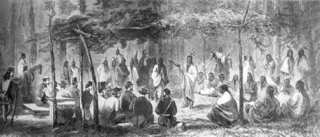
Fort Supply was originally established as "Camp of Supply" on November 18, 1868 in support of General Philip Sheridan's winter campaign against the Southern Plains Indians. [2] It was from Camp Supply that George Armstrong Custer led the Seventh United States Cavalry south to the banks of the Washita River to destroy the village of the Cheyenne Indian chief Black Kettle in what became known as the Battle of the Washita. Later, the camp served to protect the Cheyenne and Arapaho reservations, under the Darlington Agency, from incursions by whites. Camp Supply was renamed Fort Supply in 1878 following its role in the Red River War of 1874-1875.
By 1880 the Indian Wars on the Southern Plains were nearly over and the fort was in bad repair. Army officers in the Department of Missouri recommended its abandonment. Philip Sheridan, by then General of the Army, objected [3] and worked to establish the Fort Supply Military Reservation giving permanence to the fort and an accompanying reserve of 36 square miles. [4]
Fort Supply was officially closed September 1894 following the opening of the Cherokee Outlet to settlement. One of the last missions troops from Fort Supply performed was bringing to end the violence of the Enid-Pond Creek Railroad War during the summer of 1894. Troops from Fort Reno and U.S. Marshal E.D. Dix and his deputies had been unable to quell the wrecking of trains, destruction of tracks, and demolition of trestles by residents from both communities. On February 26, 1895, the last remaining troops turned over operation of the old fort to the Department of the Interior.
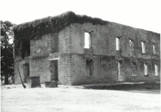
In 1908 Oklahoma's first insane asylum was established at the old post and which is now called the Western State Psychiatric Center. In 1988, the state legislature designated the remaining buildings at the old fort as the Fort Supply Historic District. Shortly afterwards the William S. Key Correctional Center was opened at the site.
The Fort Supply Historic District was placed on the National Register of Historic Places in 1971 (#71000675).

The Cheyenne are an Indigenous people of the Great Plains. Their Cheyenne language belongs to the Algonquian language family. Today, the Cheyenne people are split into two federally recognized nations: the Southern Cheyenne, who are enrolled in the Cheyenne and Arapaho Tribes in Oklahoma, and the Northern Cheyenne, who are enrolled in the Northern Cheyenne Tribe of the Northern Cheyenne Indian Reservation in Montana. The Cheyenne comprise two Native American tribes, the Só'taeo'o or Só'taétaneo'o and the Tsétsêhéstâhese. The tribes merged in the early 19th century.

The American Indian Wars, also known as the American Frontier Wars, and the Indian Wars, were fought by European governments and colonists in North America, and later by the United States government and American settlers, against various American Indian tribes. These conflicts occurred in the United States from the time of the earliest colonial settlements in the 17th century until the early 20th century. The various wars resulted from a wide variety of factors, the most common being the desire of settlers and governments for Indian tribes' lands. The European powers and their colonies also enlisted allied Indian tribes to help them conduct warfare against each other's colonial settlements. After the American Revolution, many conflicts were local to specific states or regions and frequently involved disputes over land use; some entailed cycles of violent reprisal.

Black Kettle was a prominent leader of the Southern Cheyenne during the American Indian Wars. Born to the Northern Só'taeo'o / Só'taétaneo'o band of the Northern Cheyenne in the Black Hills of present-day South Dakota, he later married into the Wotápio / Wutapai band of the Southern Cheyenne.
The Medicine Lodge Treaty is the overall name for three treaties signed near Medicine Lodge, Kansas, between the Federal government of the United States and southern Plains Indian tribes in October 1867, intended to bring peace to the area by relocating the Native Americans to reservations in Indian Territory and away from European-American settlement. The treaty was negotiated after investigation by the Indian Peace Commission, which in its final report in 1868 concluded that the wars had been preventable. They determined that the United States government and its representatives, including the United States Congress, had contributed to the warfare on the Great Plains by failing to fulfill their legal obligations and to treat the Native Americans with honesty.

The Battle of the Washita River occurred on November 27, 1868, when Lt. Col. George Armstrong Custer's 7th U.S. Cavalry attacked Black Kettle's Southern Cheyenne camp on the Washita River.
Fort Towson was a frontier outpost for Frontier Army Quartermasters along the Permanent Indian Frontier located about two miles (3 km) northeast of the present community of Fort Towson, Oklahoma. Located on Gates Creek near the confluence of the Kiamichi River and the Red River in present-day Choctaw County, Oklahoma, it was named for General Nathaniel Towson.

Fort Larned National Historic Site preserves Fort Larned which operated from 1859 to 1878. It is approximately 5.5 miles (8.9 km) west of Larned, Kansas, United States.

The Red River War was a military campaign launched by the United States Army in 1874 to displace the Comanche, Kiowa, Southern Cheyenne, and Arapaho Native American tribes from the Southern Plains, and forcibly relocate the tribes to reservations in Indian Territory. The war had several army columns crisscross the Texas Panhandle in an effort to locate, harass, and capture nomadic Native American bands. Most of the engagements were small skirmishes with few casualties on either side. The war wound down over the last few months of 1874, as fewer and fewer Indian bands had the strength and supplies to remain in the field. Though the last significantly sized group did not surrender until mid-1875, the war marked the end of free-roaming Indian populations on the southern Great Plains.

Fort Gibson is a historic military site next to the modern city of Fort Gibson, in Muskogee County Oklahoma. It guarded the American frontier in Indian Territory from 1824 to 1888. When it was constructed, the fort was farther west than any other military post in the United States. It formed part of the north–south chain of forts that was intended to maintain peace on the frontier of the American West and to protect the southwestern border of the Louisiana Purchase. The fort succeeded in its peacekeeping mission for more than 50 years, as no massacres or battles occurred there.

Fort Reno is a former United States Army cavalry post west of El Reno, Oklahoma. It is named for General Jesse L. Reno, who died at the Battle of South Mountain in the American Civil War.

Fort Hays, originally named Fort Fletcher, was a United States Army fort near Hays, Kansas. Active from 1865 to 1889 it was an important frontier post during the American Indian Wars of the late 19th century. Reopened as a historical park in 1929, it is now operated by the Kansas Historical Society as the Fort Hays State Historic Site.
Clara Blinn was an American settler who, with her two-year-old son Willie, was captured by Indians in October 1868 in Colorado Territory during an attack on the wagon train in which she and her family were traveling. She and her little boy were killed on or about November 27, 1868 during or in the immediate aftermath of the Battle of Washita River, in which the camp of the Cheyenne chief Black Kettle was attacked and destroyed by troops of the Seventh U.S. Cavalry under the command of Lt. Col. George Armstrong Custer. Clara and Willie Blinn's bodies were found some two weeks after the fight in one of several abandoned Indian camps along the Washita River near present-day Cheyenne, Oklahoma.
Fort Washita is the former United States military post and National Historic Landmark located in Durant, Oklahoma on SH 199. Established in 1842 by General Zachary Taylor to protect citizens of the Choctaw and Chickasaw Nations from the Plains Indians, it was later abandoned by Federal forces at the beginning of the American Civil War. Confederate troops held the post until the end of the war when they burned the remaining structures. It was never reoccupied by the United States military. After years in private hands the Oklahoma Historical Society bought the fort grounds in 1962 and restored the site. Today, the Fort Washita Historic Site and Museum is a tourist attraction and hosts several events throughout the year, and it is jointly managed by the Chickasaw Nation and the Oklahoma Historical Society.

The Great Sioux War of 1876, also known as the Black Hills War, was a series of battles and negotiations that occurred in 1876 and 1877 in an alliance of Lakota Sioux and Northern Cheyenne against the United States. The cause of the war was the desire of the US government to obtain ownership of the Black Hills. Gold had been discovered in the Black Hills, settlers began to encroach onto Native American lands, and the Sioux and the Cheyenne refused to cede ownership. Traditionally, American military and historians place the Lakota at the center of the story, especially because of their numbers, but some Native Americans believe the Cheyenne were the primary target of the American campaign.

Fort Arbuckle was constructed by the US Army in 1850 to counter raids by Plains Indian tribes on immigrant trains heading west to California and on the settlements of Choctaw and Chickasaw nations in Indian Territory.

Cheyenne and Arapaho Indian Reservation were the lands granted the Southern Cheyenne and the Southern Arapaho by the United States under the Medicine Lodge Treaty signed in 1867. The tribes never lived on the land described in the treaty and did not want to.

Fort Harney was a United States Army outpost in eastern Oregon in the United States. It was named in honor of Brigadier General William S. Harney. Fort Harney was used as a supply depot and administrative headquarters from 1867 to 1880 during the Army's campaign against Northern Paiute bands in Eastern Oregon and the Bannock uprising in the same area. Today, nothing remains of Fort Harney except a small cemetery.
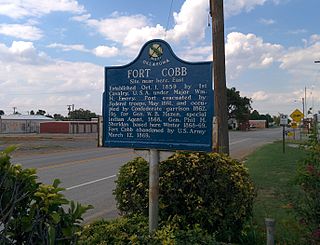
Fort Cobb was a United States Army post established in what is now Caddo County, Oklahoma in 1859 to protect relocated Native Americans from raids by the Comanche, Kiowa, and Cheyenne. The fort was abandoned by Maj. William H. Emory at the beginning of the Civil War, but then occupied by Confederate forces from 1861–1862. The post was eventually reoccupied by US forces starting in 1868. After establishing Fort Sill the US Army abandoned Fort Cobb. Today there is little left of the former military post.
The Darlington Agency was an Indian agency on the Cheyenne and Arapaho Indian Reservation prior to statehood in present-day Canadian County, Oklahoma. The agency was established in 1870. The agency established at Fort Supply the previous year was moved to a more accessible location for the tribes. Brinton Darlington, a Quaker for whom the agency was named, was the first United States Indian agent at the agency, a position he held until his death in 1872.


