The Little Colorado River is a tributary of the Colorado River in the U.S. state of Arizona, providing the principal drainage from the Painted Desert region. Together with its major tributary, the Puerco River, it drains an area of about 26,500 square miles (69,000 km2) in eastern Arizona and western New Mexico. Although it stretches almost 340 miles (550 km), only the headwaters and the lowermost reaches flow year-round. Between St. Johns and Cameron, most of the river is a wide, braided wash, only containing water after heavy snowmelt or flash flooding.

The U.S. Army Corps of Topographical Engineers was a branch of the United States Army authorized on 4 July 1838. It consisted only of officers who were handpicked from West Point and was used for mapping and the design and construction of federal civil works such as lighthouses and other coastal fortifications and navigational routes. Members included such officers as George Meade, John C. Frémont, Thomas J. Cram and Stephen Long. It was merged with the United States Army Corps of Engineers on 31 March 1863, at which point the Corps of Engineers also assumed the Lakes Survey for the Great Lakes. In the mid-19th century, Corps of Engineers' officers ran Lighthouse Districts in tandem with U.S. Naval officers.
Aubrey Landing, Aubrey City or Aubrey is a ghost town at the mouth of the Bill Williams River in southern Mohave County, Arizona, United States. The town was founded before 1865 and was abandoned sometime after 1886. Aubrey Landing was inundated when Lake Havasu was formed.

Frederick Wilhelm von Egloffstein was a German-born military man, explorer, mapmaker, landscape artist and engraver. He was the first person to employ ruled glass screens, together with photography, to produce engravings.
Robinson's Landing was a location in Baja California, Mexico. It lay on the west bank of the Colorado River northwest of the north tip of Montague Island in the Colorado River Delta, 10 miles above the mouth of the river on the Gulf of California. Named for David C. Robinson, it was the place where cargo was unloaded in the river from seagoing craft on to flatbottomed steamboats and carried up to Fort Yuma and points further north on the river from 1852 onward. Joseph C. Ives, described it as it was in 1858, in his 1861 Report upon the Colorado river of the West The river here was subject to a severe tidal bore that formed in the estuary about Montague Island and propagated upstream and could on occasion swamp barges, boats and ships. By 1865, a better location was found, ships offloaded their cargos on the east bank of the river at Port Isabel, Sonora, northeast of Montague Island. 17 miles from Robinson's landing and 57 miles below Port Famine.
Joseph Christmas Ives was an American soldier, botanist, and an explorer of the Colorado River in 1858.
The Old Tejon Pass is a mountain pass in the Tehachapi Mountains linking Southern and Central California.
Dragoon Wash, a stream tributary to the San Pedro River, in Cochise County, Arizona. It has its source just southwest of the town of Dragoon. 32°01′21″N110°02′46″W It runs southwesterly to meet the San Pedro River.

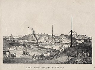
Steamboats on the Colorado River operated from the river mouth at the Colorado River Delta on the Gulf of California in Mexico, up to the Virgin River on the Lower Colorado River Valley in the Southwestern United States from 1852 until 1909, when the construction of the Laguna Dam was completed. The shallow draft paddle steamers were found to be the most economical way to ship goods between the Pacific Ocean ports and settlements and mines along the lower river, putting in at landings in Sonora state, Baja California Territory, California state, Arizona Territory, New Mexico Territory, and Nevada state. They remained the primary means of transportation of freight until the advent of the more economical railroads began cutting away at their business from 1878 when the first line entered Arizona Territory.
Pedrick's was a steamboat landing, owned by John Pedrick, supplying wood to the steamboats on the lower Colorado River in Sonora, Mexico, from the mid 1850s to the late 1870s. After the 1854 Gadsden Purchase, Pedrick's was within New Mexico Territory and Arizona Territory after 1863. Pedrick's landing was located 24 miles above Ogden's Landing and 31 miles below Fort Yuma. Pedrick's lay along the east bank of the river just above what is now the Sonora – Arizona border in modern Yuma County, Arizona.
Ogden's Landing was a steamboat landing and woodyard, owned by former Colorado River ferry partner of George Alonzo Johnson, supplying wood to the steamboats on the lower Colorado River in Sonora, Mexico, from the mid 1854 to the late 1870s. Ogden's Landing was located 28 miles above Gridiron and 24 miles below Pedrick's in Sonora until 1856, when it became part of New Mexico Territory, until it became Arizona Territory in 1863. Ogden's Landing lay along the east bank of the river 19 miles below what is now the Sonora - Arizona border.
Gridiron was a steamboat landing and woodyard on the lower Colorado River in Sonora state of northwestern Mexico,.
Port Famine was a steamboat landing and woodyard, supplying wood to the steamboats on the lower Colorado River in Sonora, Mexico, from the 1854 to the late 1870s.
Explorer was a small, custom-made stern-wheel steamboat built for Second lieutenant Joseph Christmas Ives and used by him to carry the U. S. Army Corps of Topographical Engineers expedition to explore the Colorado River above Fort Yuma in 1858.
Stone's Ferry is a former settlement founded by members of the Church of Jesus Christ of Latter-day Saints and ferry crossing of the Colorado River between Nevada and Arizona, in Clark County, Nevada, United States.
Boulder Canyon, originally Devils Gate Canyon, is a canyon on the Colorado River, above Hoover Dam, now flooded by Lake Mead. It lies between Clark County, Nevada and Mohave County, Arizona. It heads at western end of the Virgin River Basin of Lake Mead, at about 36°09′05″N114°32′51″W. Boulder Canyon divides the Black Mountains into the Black Mountains of Arizona, and the Black Mountains of Nevada. Its mouth is now under the eastern end of the Boulder Basin of Lake Mead, between Canyon Point in Nevada and Canyon Ridge in Arizona. Its original mouth is now underneath Lake Mead between Beacon Rock and Fortification Ridge on the southern shore in Arizona.
Drift Desert is a former ranch and steamboat landing on the Colorado River, now a ghost town, in La Paz County, Arizona.
Explorer's Rock was a large rock in the Colorado River that was a hazard to navigation at the mouth of the Black Canyon of the Colorado between Arizona and Nevada during the 19th century. It got its name from incident where the iron hulled steamboat Explorer struck it doing some damage, during the expedition of Lieutenant Joseph C. Ives, Corps of Topographical Engineers to explore the Colorado River of the West in 1857 and 1858.

Steamboat Mountain is a 7,410-foot-elevation (2,260-meter) summit located in the Grand Canyon, in Coconino County of northern Arizona, US. It is situated four miles northwest of Holy Grail Temple, and 2.5 miles west-southwest of Timp Point on the North Rim. George Wharton James described it as a "majestic butte", nearly encircled by Galloway and Saddle Canyons. Topographic relief is significant as it rises over 5,400 feet above the Colorado River in three miles. According to the Köppen climate classification system, Steamboat Mountain is located in a Cold semi-arid climate zone, with precipitation runoff draining west to the Colorado River via Tapeats Creek and Stone Creek. This feature's name was officially adopted in 1932 by the U.S. Board on Geographic Names.

Diamond Peak is a 3,512-foot-elevation summit located in the western end of the Grand Canyon, on the Hualapai Indian Reservation in Mohave County of northwestern Arizona, United States. This double summit landmark is situated at the mouth of Peach Springs Canyon, where Diamond Creek meets the Colorado River. This peak is an erosional remnant composed of Cambrian Muav Limestone and Mississippian Redwall Limestone. Topographic relief is significant as Diamond Peak towers 2,200 feet above the Colorado River in one-half mile. According to the Köppen climate classification system, Diamond Peak is located in a desert climate zone.


