
Darnestown is a United States census-designated place (CDP) and an unincorporated area in Montgomery County, Maryland. It is 16.39 square miles with the Potomac River as its southern border and the Muddy Branch as much of its eastern border. Seneca Creek borders portions of its north and west sides. The Travilah, North Potomac, and Germantown census-designated places are adjacent to it, as is the city of Gaithersburg. Washington, D.C. is about 25 miles (40 km) away. The Darnestown CDP has a population of approximately 6,400, while the village of Darnestown is considerably smaller.

Travilah is a United States census-designated place and an unincorporated area in Montgomery County, Maryland. It is 17.28 square miles (44.8 km2) located along the north side of the Potomac River, and surrounded by the communities of Potomac, North Potomac, and Darnestown—all census-designated places. It has a population of nearly 12,000.

The Chesapeake and Ohio Canal, abbreviated as the C&O Canal and occasionally called the "Grand Old Ditch," operated from 1831 until 1924 along the Potomac River from Washington, D.C., to Cumberland, Maryland. The canal's principal cargo was coal from the Allegheny Mountains.

Point of Rocks is an unincorporated community and census-designated place (CDP) in Frederick County, Maryland, United States. As of the 2010 census it had a population of 1,466. It is named for the striking rock formation on the adjacent Catoctin Mountain, which was formed by the Potomac River cutting through the ridge in a water gap, a typical formation in the Appalachian Mountains. The formation is not visible from the town and can only be seen from boats on the river, or from the southern bank of the river in Virginia.

The Chesapeake and Ohio Canal National Historical Park is located in the District of Columbia and the state of Maryland. The park was established in 1961 as a National Monument by President Dwight D. Eisenhower to preserve the neglected remains of the Chesapeake and Ohio Canal and many of its original structures. The canal and towpath trail extends along the Potomac River from Georgetown, Washington, D.C., to Cumberland, Maryland, a distance of 184.5 miles (296.9 km). In 2013, the path was designated as the first section of U.S. Bicycle Route 50.

A canal pound, reach, or level, is the stretch of level water impounded between two canal locks. Canal pounds can vary in length from the non-existent, where two or more immediately adjacent locks form a lock staircase, to many miles.

The Patowmack Canal is a series of five inoperative canals located in Maryland and Virginia, United States, that was designed to bypass rapids in the Potomac River upstream of the present Washington, D.C. area. The most well known of them is the Great Falls skirting canal, whose remains are managed by the National Park Service as it is within Great Falls Park Virginia, an integral part of the George Washington Memorial Parkway.

The James River and Kanawha Canal was a partially built canal in Virginia intended to facilitate shipments of passengers and freight by water between the western counties of Virginia and the coast. Ultimately its towpath became the roadbed for a rail line following the same course.
The Monocacy Aqueduct — or C&O Canal Aqueduct No. 2 — is the largest aqueduct on the Chesapeake and Ohio Canal, crossing the Monocacy River just before it empties into the Potomac River in Frederick County, Maryland, USA. The 438 foot aqueduct was built by three separate contractors between 1829 and 1833 at a cost of US$127,900.

The National Register of Historic Places in the United States is a register including buildings, sites, structures, districts, and objects. The Register automatically includes all National Historic Landmarks as well as all historic areas administered by the U.S. National Park Service. Since its introduction in 1966, more than 90,000 separate listings have been added to the register.
The Schuylkill Canal, or Schuylkill Navigation, was a system of interconnected canals and slack-water pools along the Schuylkill River in the U.S. state of Pennsylvania, built as a commercial waterway in the early 19th-century. Chartered in 1815, the navigation opened in 1825 to provide transportation and water power. At the time, the river was the least expensive and most efficient method of transporting bulk cargo, and the eastern seaboard cities of the U.S. were experiencing an energy crisis due to deforestation. It fostered the mining of anthracite coal as the major source of industry between Pottsville and eastern markets. Along the tow-paths, mules pulled barges of coal from Port Carbon through the water gaps to Pottsville; locally to the port and markets of Philadelphia; and some then by ship or through additional New Jersey waterways, to New York City markets.

Seneca Creek is a 5.8-mile-long (9.3 km) stream in Montgomery County, Maryland, USA, roughly 16 miles (26 km) northwest of Washington, D.C. It drains into the Potomac River.

The Tidewater Lock is a dam in Washington, D.C. to the west of the mouth of Rock Creek at the Potomac River, on the east side of Georgetown. Built to connect the Chesapeake and Ohio Canal, opened in 1831, with the Potomac, it was a busy maritime intersection during several decades of the canal's heyday. C&O documents refer to it variously as Lock 0 and Tide Lock A.

The Locks on the Chesapeake and Ohio Canal, located in Maryland, West Virginia, and Washington, D.C. of the United States, were of three types: lift locks; river locks; and guard, or inlet, locks.

Fort Tonoloway State Park is an undeveloped Maryland state park located near present-day Hancock. Fort Tonoloway was a frontier fort built in 1755 by Lt. Thomas Stoddert and men from the Maryland State Militia. The fort was also known as Stoddert's Fort. It was abandoned in 1756 when Fort Frederick was constructed.

Power Plant and Dam No. 5, also known as Honeywood Dam, comprises a dam on the Potomac River, originally built for the Chesapeake and Ohio Canal, and a power plant built to take advantage of the river's flow to generate hydroelectric power. The dam is included in Chesapeake and Ohio Canal National Historical Park.

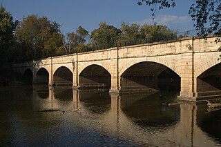
Seneca Aqueduct — or Aqueduct No. 1 — is a naviduct that carries the Chesapeake and Ohio Canal (C&O) over Seneca Creek in Montgomery County, Maryland. The C&O built eleven aqueducts along its 184.5 miles (296.9 km) length. Seneca Aqueduct is a unique structure, not only being the first built, but also the only red sandstone aqueduct on the C&O−and the only aqueduct that is also a lock. It is located at the end of Riley's Lock Road in Seneca, Maryland.

The Pennyfield Lock and lockhouse are part of the 184.5-mile (296.9 km) Chesapeake and Ohio Canal that operated in the United States along the Potomac River from the 1830s through 1923. The lock, located at towpath mile-marker 19.7, is near River Road in Montgomery County, Maryland. The original lock house was built in 1830, and its lock was completed in 1831.

Swains Lock and lock house are part of the 184.5-mile (296.9 km) Chesapeake and Ohio Canal that operated in the United States along the Potomac River from the 1830s through 1923. It is located at towpath mile-marker 16.7 near Potomac, Maryland, and within the Travilah census-designated place in Montgomery County, Maryland. The lock and lock house were built in the early 1830s and began operating shortly thereafter.

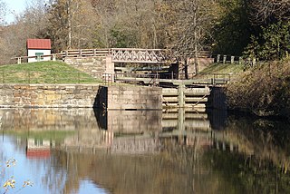
Riley's Lock (Lock 24) and lock house are part of the 184.5-mile (296.9 km) Chesapeake and Ohio Canal that operated in the United States along the Potomac River from the 1830s through 1923. They are located at towpath mile-marker 22.7 adjacent to Seneca Creek, in Montgomery County, Maryland. The lock is sometimes identified as Seneca because of the Seneca Aqueduct that carried the canal over the creek to the lift lock. The name Riley comes from John C. Riley, who was lock keeper from 1892 until the canal closed permanently in 1924.


