Franklin, Idaho

Last updated
Franklin, Idaho
Franklin, Idaho.jpg
Street Scene in Franklin
Franklin County Idaho Incorporated and Unincorporated areas Franklin Highlighted 1628810.svg
Location of Franklin in Franklin County, Idaho
Coordinates: 42°0′58″N111°48′11″W / 42.01611°N 111.80306°W / 42.01611; -111.80306
Country United States
State Idaho
County Franklin
Founded1860
Government
  MayorJohn Packer (2023)
Area
[1]
  Total1.33 sq mi (3.44 km2)
  Land1.30 sq mi (3.37 km2)
  Water0.03 sq mi (0.07 km2)
Elevation
4,501 ft (1,372 m)
Population
 (2010) [2]
  Total641
  Estimate 
(2019) [3]
835
  Density641.32/sq mi (247.60/km2)
Time zone UTC-7 (Mountain (MST))
  Summer (DST) UTC-6 (MDT)
ZIP code
83237
Area code 208
FIPS code 16-28810
GNIS feature ID0372775
Website franklinidaho.org

Franklin is a city in Franklin County, Idaho, United States. The population was 641 at the 2010 census. [4] It is part of the Logan, Utah-Idaho Metropolitan Statistical Area.

Contents

History

The town was founded by Mormon pioneers led by Thomas S. Smart on April 14, 1860, in what was then Washington Territory, although at the time it was believed the settlement was within the bounds of Utah Territory. The town was named for Franklin Richards, an Apostle for the Church of Jesus Christ of Latter-day Saints. [5] Franklin is the first permanent European settlement in present-day Idaho. Its political status remained ambiguous until an 1872 survey determined the townsite was in Idaho Territory about 1-mile (1.6 km) north of the Utah Territory border. [6] The area within the town limits was platted into square blocks in 1864. [7]

Part of the 2004 comedy film Napoleon Dynamite were shot near Franklin. The chicken farm scenes were filmed on Ritewood Egg Farms property, and the supervisor's character is loosely based on Marlow Woodward, a late Franklin resident and one of the farm's founders. [8]

Welcome sign near Franklin Welcome to Franklin, Idaho.jpg
Welcome sign near Franklin

Geography

Franklin is located at 42°0′58″N111°48′11″W / 42.01611°N 111.80306°W / 42.01611; -111.80306 (42.016039, -111.803101). [9] at an elevation of 4,501 feet (1,372 m) above sea level.

According to the United States Census Bureau, the city has a total area of 1.29 square miles (3.34 km2), of which, 1.26 square miles (3.26 km2) is land and 0.03 square miles (0.08 km2) is water. [10]

Demographics

Historical population
CensusPop.Note
1900 435
1910 53422.8%
1920 58910.3%
1930 531−9.8%
1940 523−1.5%
1950 467−10.7%
1960 446−4.5%
1970 402−9.9%
1980 4235.2%
1990 47813.0%
2000 64134.1%
2010 6410.0%
2020 1,02559.9%
U.S. Decennial Census [11]

2010 census

As of the census [2] of 2010, there were 641 people, 221 households, and 155 families living in the city. The population density was 508.7 inhabitants per square mile (196.4/km2). There were 236 housing units at an average density of 187.3 per square mile (72.3/km2). The racial makeup of the city was 91.1% White, 0.5% African American, 0.5% Native American, 6.2% from other races, and 1.7% from two or more races. Hispanic or Latino of any race were 13.1% of the population.

There were 221 households, of which 42.5% had children under the age of 18 living with them, 62.4% were married couples living together, 5.0% had a female householder with no husband present, 2.7% had a male householder with no wife present, and 29.9% were non-families. 26.7% of all households were made up of individuals, and 12.2% had someone living alone who was 65 years of age or older. The average household size was 2.90 and the average family size was 3.61.

The median age in the city was 29.9 years. 34.3% of residents were under the age of 18; 9.8% were between the ages of 18 and 24; 23.9% were from 25 to 44; 19.2% were from 45 to 64; and 12.6% were 65 years of age or older. The gender makeup of the city was 49.8% male and 50.2% female.

2000 census

As of the census [12] of 2000, there were 641 people, 195 households, and 156 families living in the city. The population density was 839.0 inhabitants per square mile (323.9/km2). There were 219 housing units at an average density of 286.6 per square mile (110.7/km2). The racial makeup of the city was 88.92% White, 0.16% Native American, 9.05% from other races, and 1.87% from two or more races. Hispanic or Latino of any race were 9.67% of the population.

There were 195 households, out of which 47.7% had children under the age of 18 living with them, 69.2% were married couples living together, 5.1% had a female householder with no husband present, and 20.0% were non-families. 17.9% of all households were made up of individuals, and 10.8% had someone living alone who was 65 years of age or older. The average household size was 3.29 and the average family size was 3.79.

In the city, the population was spread out, with 40.1% under the age of 18, 8.9% from 18 to 24, 26.8% from 25 to 44, 14.7% from 45 to 64, and 9.5% who were 65 years of age or older. The median age was 26 years. For every 100 females, there were 94.2 males. For every 100 females age 18 and over, there were 101.0 males.

The median income for a household in the city was $33,026, and the median income for a family was $34,191. Males had a median income of $27,417 versus $24,000 for females. The per capita income for the city was $10,346. About 10.9% of families and 14.1% of the population were below the poverty line, including 19.0% of those under age 18 and 10.3% of those age 65 or over.

Related Research Articles

<span class="mw-page-title-main">Oneida County, Idaho</span> County in Idaho, United States

Oneida County is a county located in the U.S. state of Idaho. As of the 2020 Census the county had a population of 4,564. The county seat and largest city is Malad City. Most of the county's population lives in Malad City and the surrounding Malad Valley.

<span class="mw-page-title-main">Minidoka County, Idaho</span> County in Idaho, United States

Minidoka County is a county located in the U.S. state of Idaho. As of the 2020 census, the population was 21,613. The county seat and largest city is Rupert.

<span class="mw-page-title-main">Franklin County, Idaho</span> County in Idaho, United States

Franklin County is a county located in the U.S. state of Idaho. As of the 2020 Census the county had a population of 14,194. The county seat and largest city is Preston. The county was established in 1913 and named after Franklin D. Richards, an Apostle of the Church of Jesus Christ of Latter-day Saints. It is the only Franklin County in the United States that is not named after Benjamin Franklin. Franklin County is part of the Logan, UT-ID Metropolitan Statistical Area.

<span class="mw-page-title-main">Chubbuck, Idaho</span> City in Idaho, United States

Chubbuck is a city in Bannock County, Idaho. It is part of the Pocatello Metropolitan Statistical Area. The population was 13,922 at the 2010 census. Chubbuck is located immediately north of Pocatello, Idaho, and has opposed several consolidation proposals since the 1960s.

<span class="mw-page-title-main">McCammon, Idaho</span> City in Idaho, United States

McCammon is a city in Bannock County, Idaho, United States. It is part of the Pocatello, Idaho Metropolitan Statistical Area'. The population was 809 at the 2010 census. In 1892, McCammon became the junction point between the Oregon Short Line Railroad and Utah and Northern Railway, and city gained the nickname Junction City.

<span class="mw-page-title-main">Paris, Idaho</span> City in Idaho, United States

Paris is a city and county seat of Bear Lake County, Idaho, United States. Located on the western side of the Bear Lake Valley, the city's population was 513 at the 2010 census, down from 576 in 2000. Paris was settled on September 26, 1863, by pioneer settlers of the Church of Jesus Christ of Latter-day Saints.

<span class="mw-page-title-main">St. Charles, Idaho</span> City in Idaho, United States

St. Charles is a city in southern Bear Lake County, Idaho, United States, that is located near the northwestern shore of Bear Lake. Its population was 131 at the 2010 census, down from 156 in 2000.

<span class="mw-page-title-main">Albion, Idaho</span> City in Idaho, United States

Albion is a city in Cassia County, Idaho, United States. It is part of the Burley, Idaho Micropolitan Statistical Area. The population was 234 at the 2020 census. Albion was the county seat of Cassia County from 1879 to 1918.

<span class="mw-page-title-main">Clifton, Idaho</span> City in Idaho, United States

Clifton is a city in Franklin County, Idaho, United States. The population was 259 at the 2010 census. It is part of the Logan, Utah-Idaho Metropolitan Statistical Area.

<span class="mw-page-title-main">Dayton, Idaho</span> City in Idaho, United States

Dayton is a city in Franklin County, Idaho, United States. The population was 463 at the 2010 census. It is part of the Logan, Utah-Idaho Metropolitan Statistical Area.

<span class="mw-page-title-main">Preston, Idaho</span> City in Idaho, United States

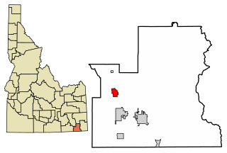
Preston is a city in Franklin County, Idaho, United States. The population was 5,204 at the 2010 census. The city is the county seat of Franklin County. It is part of the Logan, Utah-Idaho Metropolitan Statistical Area.

<span class="mw-page-title-main">Weston, Idaho</span> City in Idaho, United States

Weston is a city in Franklin County, Idaho, United States. The population was 437 at the 2010 census. It is part of the Logan, Utah-Idaho Metropolitan Statistical Area. It was first settled in 1865. The community was so named on account of its location at the west bank of the Bear River.

<span class="mw-page-title-main">Sugar City, Idaho</span> City in Idaho, United States

Sugar City is a city in Madison County, Idaho, United States. The population was 1,715 at the 2020 census, up from 1,514 in 2010. It is part of the Rexburg Micropolitan Statistical Area.

<span class="mw-page-title-main">Heyburn, Idaho</span> City in Idaho, United States

Heyburn is a city in Minidoka County, Idaho, United States. The population was 3,700 at the 2020 census, up from 3,089 in 2010. It is part of the Burley micropolitan area.

<span class="mw-page-title-main">Wolf Lake, Minnesota</span> City in Minnesota, United States

Wolf Lake is a city in Becker County, Minnesota, United States. The population was 71 at the 2020 census.

<span class="mw-page-title-main">New Franklin, Missouri</span> City in Missouri, United States

New Franklin is a city in Howard County, Missouri, United States. The population was 1,027 at the 2020 census. It is part of the Columbia, Missouri Metropolitan Statistical Area.

<span class="mw-page-title-main">Cornish, Utah</span> Town in the state of Utah, United States

Cornish is a town in Cache County, Utah, United States. The population was 288 at the 2010 census. It is included in the Logan, Utah-Idaho (partial) Metropolitan Statistical Area.

<span class="mw-page-title-main">Lewiston, Utah</span> City in Utah, United States

Lewiston is a city in Cache County, Utah, United States. It is situated at the northern Utah border and borders the state of Idaho. The population was 1,766 at the 2010 census. It is included in the Logan, Utah-Idaho (partial) Metropolitan Statistical Area.

<span class="mw-page-title-main">River Heights, Utah</span> City in Utah, United States

River Heights is a city in Cache County, Utah, United States. The population was 1,734 at the 2010 census. It is included in the Logan, Utah-Idaho (partial) Metropolitan Statistical Area.

<span class="mw-page-title-main">Trenton, Utah</span> Town in Utah, United States

Trenton is a town in Cache County, Utah, United States. The population was 464 at the 2010 census. It is included in the Logan, Utah-Idaho (partial) Metropolitan Statistical Area.

References

  1. "2019 U.S. Gazetteer Files". United States Census Bureau. Retrieved July 9, 2020.
  2. 1 2 "U.S. Census website". United States Census Bureau. Retrieved 18 December 2012.
  3. Spokesman-Review Archived 2016-03-04 at the Wayback Machine - 2010 census - Franklin, Idaho - accessed 26 December 2011
  4. The Utah Genealogical and Historical Magazine, Volumes 9-10. 1918. p. 128.
  5. Eldon T. Bennett (November 2004). "An Early History of Franklin". Franklinidaho.org. Archived from the original on 2012-07-22.
  6. William Fleuitt - History accessed 3 January 2018
  7. United Egg Producers article Archived 2009-09-14 at the Wayback Machine , accessed 27 September 2009.
  8. "US Gazetteer files: 2010, 2000, and 1990". United States Census Bureau. 12 February 2011. Retrieved 23 April 2011.
  9. "US Gazetteer files 2010". United States Census Bureau. Archived from the original on 2 July 2012. Retrieved 18 December 2012.
  10. "Census of Population and Housing". Census.gov. Retrieved 4 June 2015.
  11. "U.S. Census website". United States Census Bureau. Retrieved 31 January 2008.

Further reading

  1. IDAHO SEMI-CENTENNIAL CELEBRATION (1910), Idaho facts and statistics; pertaining to its early settlement and colonization with special reference to the Franklin Colony together with stories of the Indian troubles in the southeastern part of the state, Salt Lake City: IDAHO SEMI-CENTENNIAL CELEBRATION