Franklin Township is a township in Somerset County, in the U.S. state of New Jersey. It is centrally located in the Raritan Valley region, within the New York Metropolitan Area. As of the 2020 United States census, the township's population was 68,364, an increase of 6,064 (+9.7%) from the 2010 census count of 62,300, which in turn reflected an increase of 11,397 (+22.4%) from the 50,903 counted in the 2000 census. The township was the state's 19th most-populous municipality in 2020, after being ranked 22nd in 2010.

Washington Crossing State Park is a 3,575-acre (14 km2) New Jersey state park that is part of Washington's Crossing, a U.S. National Historic Landmark area. It is located in the Washington Crossing and Titusville sections of Hopewell Township in Mercer County, north of Trenton along the Delaware River. The park is operated and maintained by the New Jersey Division of Parks and Forestry. It is supported by the Washington Crossing Park Association, a friends group that works to preserve, enhance, and advocate for the park.
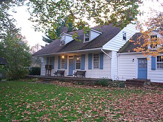
Rockingham is a historic house that was the home of John Berrien (1711–1772). It served as George Washington's final headquarters of the Revolutionary War. It is located at 84 Laurel Avenue, Franklin Township in Somerset County, New Jersey. It was listed on the National Register of Historic Places in 1970.
The Meadows Foundation of Somerset County, New Jersey is a nonprofit corporation founded in 1978. It oversaw the restoration of seven historic houses in Somerset.
Six Mile Run is an unincorporated community and census-designated place (CDP) located in Franklin Township, in Somerset County, in the U.S. state of New Jersey. As of the 2010 United States Census, the CDP's population was 3,184.

The Cornelius Low House is a Georgian manor in Piscataway, Middlesex County, New Jersey, United States, built in 1741 at Raritan Landing. The Cornelius Low House is listed on the New Jersey Register of Historic Places and National Register of Historic Places. The house currently holds the Cornelius Low House/Middlesex County Museum.

East Millstone is an unincorporated community and census-designated place (CDP) located in Franklin Township in Somerset County, in the U.S. state of New Jersey.
Old York Road, originally York Road, with reference to New York, is a roadway that was built during the 18th century to connect Philadelphia with New York City.
Weston is an unincorporated community and census-designated place (CDP) located in Franklin Township, in Somerset County, in the U.S. state of New Jersey. As of the 2010 United States Census, the CDP's population was 1,235.

The Amwell Valley is a small valley in Hunterdon County, New Jersey, between the Hunterdon Plateau and the Sourlands. It comprises Stockton, parts of Delaware Township, West Amwell, East Amwell, Flemington and Raritan Township. The region borders the Delaware River to the west and the South Branch Raritan River to the east. The entire area has elevations around 200 feet above sea level. US 202 is the main route running west to east through the valley. Old York Road also passes through the valley, taking a generally more southern route through Raritan and along the Sourlands at Mount Airy. Like the Hunterdon Plateau, Amwell Valley still has a large number of farms due to its sufficient climate, relatively flat land and the presence of silt-loams soils. The valley is home to Unionville Winery and Old York Cellars in Ringoes.

The Sourlands is a region in the central portion of the U.S. state of New Jersey that includes portions of Hunterdon County, Mercer County, and Somerset County. It is centered on Sourland Mountain and comprises parts of Lambertville, East Amwell, West Amwell, Hillsborough, Hopewell Boro, Hopewell Township, and Montgomery Township. The region is flanked by the Hopewell Fault to the south and Amwell Valley to the north that runs from Mount Airy to an area just west of Flagtown and a diabase formation running from Lambertville to Mount Airy. The Sourland also include a hilly area towards the southwest called Pleasant Valley, with a number of farms. Although much of the Sourlands is not conducive to farming, Pleasant Valley and the slopes on the surrounding ridges have a number of farms. The slopes of the ridge to the north are also home to Unionville Vineyard.

The Middlebush Village Historic District is a historic district located in the Village of Middlebush, an unincorporated community within Franklin Township, Somerset County, New Jersey. The district was added to the National Register of Historic Places on April 24, 2007. It includes 37 contributing buildings and three contributing sites.

The Van Voorhees–Quackenbush House, also known as the Zabriskie House, is a historic stone house located at 421 Franklin Avenue in the township of Wyckoff in Bergen County, New Jersey, United States. The oldest section was built around 1740 by William Van Voorhees and enlarged in 1824 by Albert Van Voorhees. The original section of the house is now the dining room and part of the kitchen. The home was purchased in 1867 by Uriah Quackenbush. His granddaughter Grace Quackenbush Zabriskie bequeathed the home to the township in 1973. It was documented as the Albert Van Voorhis House by the Historic American Buildings Survey (HABS) in 1937. The house was added to the National Register of Historic Places on January 10, 1983, for its significance in architecture. It was listed as part of the Early Stone Houses of Bergen County Multiple Property Submission (MPS).

The Van Voorhis–Quackenbush House is a historic stone house located at 625 Wyckoff Avenue in the township of Wyckoff in Bergen County, New Jersey, United States. The house was built in 1784 by John A. Van Voorhis. It was documented as the Corines Quackenbush House by the Historic American Buildings Survey (HABS) in 1941. The house was added to the National Register of Historic Places on July 24, 1984, for its significance in architecture and exploration/settlement. It was listed as part of the Early Stone Houses of Bergen County Multiple Property Submission (MPS).

Colonial Farms, also known as the Voorhees House, is located at 1719 Amwell Road in the Middlebush section of Franklin Township, Somerset County, New Jersey, United States. It was built in 1793 by P. Metz in a Georgian style. It is part of the Middlebush Village Historic District. The oldest building in the district, it was used in 1834 to organize the Middlebush Reformed Church. The location also includes a contributing large, red shingle, 19th-century Dutch barn. It is now the Stage House Tavern.

The Village Inn, also known as the Davis Tavern, is located at the corner of Water and Main Streets in the borough of Englishtown in Monmouth County, New Jersey. The oldest section of the building dates to 1732. It was documented by the Historic American Buildings Survey in 1936, with addendum in 1984. The tavern was added to the National Register of Historic Places on November 13, 1972, for its significance in architecture and military history.

The General John Frelinghuysen House is a historic building located in Raritan, New Jersey. The older west wing was originally a tavern, built sometime before 1756 by Cornelius Bogert, when it also served as the town's meeting hall. It was bought in 1801 by John Frelinghuysen and then came to be known as the Frelinghuysen Homestead. It is an excellent example of early 19th century Federal architecture in New Jersey. In 1975, it was donated by Peter Frelinghuysen, Jr. to the borough and now serves as the Raritan Public Library.

The Millstone Historic District is a historic district located in Millstone, Somerset County, New Jersey. The district was added to the National Register of Historic Places on September 13, 1976 for its significance in education, military history, settlement, and transportation. It includes 58 contributing buildings.
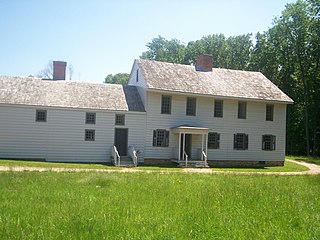
The Van Veghten House is a historic building in the Finderne section of Bridgewater Township, New Jersey. It was built around 1725 and served as the headquarters of Quartermaster General Nathanael Greene during the second Middlebrook encampment (1778–79) in the American Revolutionary War. The Somerset County Historical Society owns the house and uses it as its headquarters, including a museum and library. The early 18th-century Old York Road passed by here connecting Philadelphia to New York City. The house was added to the National Register of Historic Places on October 10, 1979 and noted as representing "one of the few remaining Raritan River mansions".

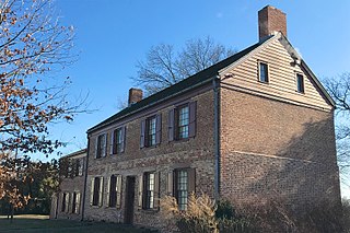
The Van Horne House is a historic building at 941 East Main Street near Bound Brook in Bridgewater Township, Somerset County, New Jersey. The house was built c. 1750 and also known as Phil's Hill, after its owner, Philip Van Horne. It served as the headquarters for American General Benjamin Lincoln in 1777, during the American Revolutionary War, in particular the Battle of Bound Brook. Later, it served as the headquarters for American General William Alexander, Lord Stirling during the second Middlebrook encampment (1778–79). The house, on the early-18th-century Old York Road that connected Philadelphia to New York City, was a New Jersey landmark during the war. Since 2002, the Heritage Trail Association has used the house as its headquarters, including an exhibit space. It was added to the National Register of Historic Places on March 8, 2002, for its locally significant Colonial Revival architecture from 1937 to 1944.


