Franklinton, North Carolina

Last updated

Franklinton, North Carolina
Franklinton Main Street edited.jpg
Downtown Franklinton
Franklinton Town Seal New.jpg
Motto(s): 
Small Town, Home Town, Your Town
NCMap-doton-Franklinton.PNG
Location of Franklinton, North Carolina
Coordinates: 36°06′04″N78°27′18″W / 36.10111°N 78.45500°W / 36.10111; -78.45500
Country United States
State North Carolina
County Franklin
Established1839
IncorporatedDecember 20, 1842 [1]
Named for Benjamin Franklin
Government
  Type Board of Commissioners
   Mayor Arthur L. Wright (D)
Area
[2]
  Total2.41 sq mi (4.52 km2)
  Land2.40 sq mi (4.50 km2)
  Water0.01 sq mi (0.02 km2)
Elevation
[3]
404 ft (123 m)
Population
 (2020)
  Total2,456
  Density1,413.93/sq mi (545.81/km2)
Time zone UTC-5 (Eastern (EST))
  Summer (DST) UTC-4 (EDT)
ZIP code
27525
Area code(s) 919 and 984
FIPS code 37-24720 [4]
GNIS feature ID2406521 [3]
Website https://www.franklintonnc.us

Franklinton is a town in Franklin County, North Carolina, United States. The population was 2,456 at the 2020 census.

Contents

History

Franklinton, was established as Franklin Depot in 1839 on land owned by Shemuel Kearney (1791–1860), son of Crawford Kearney and Nancy White. A home constructed by grandfather Shemuel Kearney (1734–1808) was originally located south of town and is currently the second oldest residence in Franklin County, built in 1759. The building was purchased in 2009 and moved to nearby Louisburg for restoration. Franklin Depot changed its name to Franklinton in 1842 when the town was incorporated. Like Franklin County, Franklinton was named for Benjamin Franklin. [5] [6]

Generous offers by local businessmen Washington Duke and Julian S. Carr brought Trinity College to the city of Durham [7] in 1892. [8] This well known school is now called Duke University. A source from the University Archives states that nearby Raleigh was actually the initial approved bidder. [7] This does not mean Franklinton wasn't included as a possible site, mentioned by some locals, even though no other bidding communities are mentioned. The citizens of Raleigh offered land now occupied by North Carolina State University and pledged $35,000.00 for a new building which was quickly approved by the Methodist Conference for Trinity College. It eventually lost to a higher bid of $85,000.00 plus donations in 1890.

In December 1919, an African-American veteran of World War I named Powell Green got involved in an altercation with a white man named R.M. Brown over smoking in the movie theater, and Green allegedly killed Brown. [9] The police arrested Green, but then a lynch mob seized him, pulled him behind a car for two miles, and hung him from a tree. [10] [11]

Franklinton was once home to Albion Academy, a co-educational African-American school started by clergyman Moses A. Hopkins in 1879. Once a State Normal & Industrial School (trade school), it eventually became a graded school and later merged with the B.F. Person School in 1957 to become B.F. Person-Albion High School. When schools were fully integrated, the upper grades consolidated with Franklinton High School in 1969. Mary Little was the first African-American teacher to begin teaching at the newly integrated Franklinton High School, who taught there till her death in 1984. The B.F. Person-Albion High School was renamed Franklinton Elementary School.

Also located in Franklinton is the historic Sterling Cotton Mill, founded by Samuel C. Vann and first opened in 1895. Remaining in the Vann family for many years, the mill was purchased in 1972 by Union Underwear Company, manufacturers of Fruit of the Loom fabric products. Sterling Cotton Mill eventually closed in 1991. It was placed on the National Register of Historic Places in 1996. [12]

Burlington Industries, another well known textile and fabric maker at the time, had a facility located in Franklinton known as Vamoco Mills. It closed in 1989, and was demolished in 2007. A third mill was also located in Franklinton which has since closed.

On June 10, 1946, former heavyweight champion Jack Johnson died in a car crash on U.S. Highway 1 in Franklinton.

On April 4, 1963, the entire town of Franklinton was threatened by a large wildfire which consumed roughly 9,500 acres (38 km2) of woodlands and destroyed several homes north and west of town. A similar incident occurred on February 10, 2008, covering practically the same area (though not as widespread), about 1,000 acres (4.0 km2). There were a couple homes which were damaged during that event. U.S. Highway 1 was temporarily closed adjacent to the affected area while firefighters battled the fires. No injuries were reported. High winds and dry conditions were factors in both incidents.

In 1996 Franklinton, North Carolina became the home of Opio Holy Spirit Academy a private school providing an academic arena for both academically gifted and students who face academic challenges from grades k-12. The school was established and directed by Lenora E. Attles-Allen a former elementary school teacher from Boston, Massachusetts. Allen's work became known and respected in Wake, Granville, Vance, and Franklin counties as well as her dedication to the Franklin County Community Restitution Program. Opio Holy Spirit Academy closed its doors for the last time after the final High School commencement ceremony in 2012.

Charles Draughn III was elected to the mayoral position of Franklinton for 8 years, from 1987 to 1995. He is currently working with family law. He was followed in office by Larry Kearney from 1995 to 2003, Jenny McGhee Edwards from 2003 to 2007 and Elic Senter from 2007 to 2015. Current Mayor Art Wright was elected in 2015. [13]

Franklinton has been a Tree City USA community since 1985. [14]

In addition to the Sterling Cotton Mill, the Franklinton Depot, Dr. J. H. Harris House, Shemuel Kearney House, C.L. and Bessie G. McGhee House, Person-McGhee Farm, Dr. J. A. Savage House, and Aldridge H. Vann House are listed on the National Register of Historic Places. [12] All properties are privately owned and should be respected.

Geography

According to the United States Census Bureau, the town has a total area of 1.6 square miles (4.1 km2), all land.

The center of town is at Main Street (U.S. Highway 1A) and Mason Street. Green Street (N.C. Highway 56) passes just south of that point and U.S. Highway 1 bypasses Franklinton to the west. The town is located approximately 30 miles (48 km) northeast of Raleigh, North Carolina and 4 miles (6.4 km) south of the Tar River.

A railway operated by CSX Transportation currently passes through Franklinton, which is part of the old Seaboard Coast Line Railroad "S-Line". [15] There was also a spur off this line which ran 10 miles (16 km) east from Franklinton to Louisburg, originally built in 1884 by the Louisburg Railroad and leased to the Raleigh & Gaston Railroad as a branch line. [16] The two lines were taken over by Seaboard Air Line Railroad in 1900. From 1985 to 1988, the Franklin County Railroad operated the branch line from Franklinton to Louisburg. [17] [18] The section was sold to the North Carolina Department of Transportation in 1990 and the tracks removed a few years later. [19]

Demographics

Historical population
CensusPop.Note
1860 160
1870 30590.6%
1880 48458.7%
1890 58320.5%
1900 76130.5%
1910 8096.3%
1920 1,05830.8%
1930 1,32024.8%
1940 1,273−3.6%
1950 1,41411.1%
1960 1,5137.0%
1970 1,459−3.6%
1980 1,394−4.5%
1990 1,61515.9%
2000 1,7458.0%
2010 2,02315.9%
2020 2,45621.4%
U.S. Decennial Census [20]

2020 census

Franklinton racial composition [21]
RaceNumberPercentage
White (non-Hispanic)1,12145.64%
Black or African American (non-Hispanic)1,01241.21%
Native American 60.24%
Asian 220.9%
Other/Mixed 1295.25%
Hispanic or Latino 1666.76%

As of the 2020 United States census, there were 2,456 people, 883 households, and 602 families residing in the town.

2010 census

As of the census [4] of 2010, there were 2,023 people, 876 households, and 551 families residing in the town. The population density was 1,264.4 inhabitants per square mile (488.2/km2). The racial makeup of the town was 55.8% White, 40.8% African American, 0.1% Native American, 0.2% Asian, 0.0% Pacific Islander, 0.7% from other races, and 2.3% from two or more races. Hispanic or Latino of any race were 4.1% of the population.

There were 876 households, out of which 23.2% had children under the age of 18 living with them, 35.8% were married couples living together, 21.7% had a female householder with no husband present, and 37.1% were non-families. 33.1% of all households were made up of individuals, and 16.1% had someone living alone who was 65 years of age or older. The average household size was 2.31 and the average family size was 2.92.

In the town, the population was spread out, with 25.7% under the age of 20, 8.3% from 20 to 24, 24.9% from 25 to 44, 21.4% from 45 to 64, and 19.8% who were 65 years of age or older. The median age was 41.4 years. For every 100 females, there were 84.4 males. For every 100 females age 18 and over, there were 80.2 males.

The median income for a household in the town was $30,082, and the median income for a family was $37,656. Males had a median income of $38,015 versus $33,380 for females. The per capita income for the town was $18,193. About 31.9% of families and 36.1% of the population were below the poverty line, including 62.7% of those under age 18 and 18.3% of those age 65 or over.

Housing

There were 1,008 housing units at an average density of 630.0 per square mile (243.2/km2). 13.1% of housing units were vacant.

There were 876 occupied housing units in the town. 553 were owner-occupied units (63.1%), while 323 were renter-occupied (36.9%). The homeowner vacancy rate was 4.1% of total units. The rental unit vacancy rate was 6.9%. [4]

Government

Franklinton is governed by a mayor and five-member Board of Commissioners, who are elected in staggered four-year terms. [22]

Notable people

Related Research Articles

<span class="mw-page-title-main">Franklin County, North Carolina</span> County in North Carolina, United States

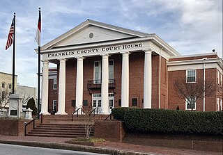
Franklin County is a county located in the U.S. state of North Carolina. As of the 2020 census, the population was 68,573. Its county seat is Louisburg.

<span class="mw-page-title-main">Louisburg, Kansas</span> City in Kansas, United States

Louisburg is a city in Miami County, Kansas, United States. As of the 2020 census, the population of the city was 4,969.

<span class="mw-page-title-main">Chocowinity, North Carolina</span> Town in North Carolina, United States

Chocowinity is a town in Beaufort County, North Carolina, United States. The population was 820 at the 2010 Census. The town is a part of the Washington Area located in North Carolina's Coastal Plains region.

<span class="mw-page-title-main">Bunn, North Carolina</span> Town in North Carolina, United States

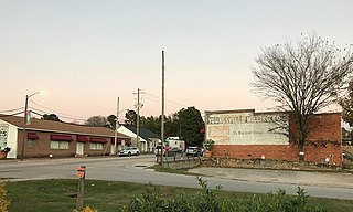
Bunn is a town in Franklin County, North Carolina, United States. The population was 327 at the 2020 census.

<span class="mw-page-title-main">Centerville, North Carolina</span> Census-designated place in North Carolina, United States

Centerville is a census-designated place (CDP) in the rural northeastern corner of Franklin County, North Carolina, United States. The population was 149 at the 2020 census. It was an incorporated town from 1965 to 2017.

<span class="mw-page-title-main">Louisburg, North Carolina</span> Town in North Carolina, United States

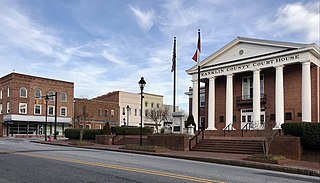
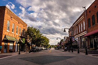
Louisburg is a town and the county seat of Franklin County, North Carolina, United States. As of the 2020 census, the town population was 3,064. The town is located approximately 29 miles northeast of the state capital, Raleigh, and located about 31 miles south of the Virginia border. It is also the home of Louisburg College, the oldest two-year coeducational college in the United States.

<span class="mw-page-title-main">Youngsville, North Carolina</span> Town in North Carolina, United States

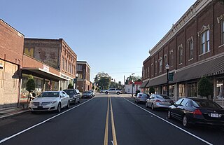
Youngsville is a town in Franklin County, North Carolina, United States. The population was 2,016 at the 2020 census.

<span class="mw-page-title-main">Creedmoor, North Carolina</span> City in North Carolina, United States

Creedmoor is a city in Granville County, North Carolina, United States. The population was 4,124 at the 2010 census.

<span class="mw-page-title-main">Weldon, North Carolina</span> Town in North Carolina, United States

Weldon is a town in Halifax County, North Carolina, United States. The population was 1,655 at the 2010 census. It is part of the Roanoke Rapids, North Carolina Micropolitan Statistical Area.

<span class="mw-page-title-main">Ahoskie, North Carolina</span> Town in North Carolina, United States

Ahoskie is a town in Hertford County, North Carolina, United States. The population was 5,039 at the 2010 census. Ahoskie is located in North Carolina's Inner Banks region. Its nickname is "The Only One" because no other town in the world is known by the same name. The etymology of the word Ahoskie, which was originally spelled "Ahotsky", was from the Wyanoke Indians, who entered the Hertford County area at the beginning of European settlement.

<span class="mw-page-title-main">Selma, North Carolina</span> Town in North Carolina, United States

Selma is a town in Johnston County, North Carolina, United States. In 2010, the population was 6,073, and as of 2018 the estimated population was 6,913. Selma is part of the Raleigh-Durham-Cary Combined Statistical Area. The area has a population over 1.7 million residents, though the town of Selma is able to maintain its rural character. The Everitt P. Stevens House, located in Selma, was the site of the last Grand Review of the Confederate Army held on April 6, 1865, after its defeat at the Battle of Bentonville.

<span class="mw-page-title-main">Parmele, North Carolina</span> Town in North Carolina, United States

Parmele is a town in Martin County, North Carolina, United States. The population was 278 at the 2010 census.

<span class="mw-page-title-main">Star, North Carolina</span> Town in North Carolina, United States

Star is a town in Montgomery County, North Carolina, United States. The population was 876 at the 2010 census.

<span class="mw-page-title-main">Apex, North Carolina</span> Town in North Carolina, United States

Apex is a town in Wake County, North Carolina, United States. At its southern border, Apex encompasses the community of Friendship. In 1994, the downtown area was designated a historic district, and the Apex train depot, built in 1867, is designated a Wake County landmark. The depot location marks the highest point on the old Chatham Railroad, hence the town's name. The town motto is "The Peak of Good Living".

<span class="mw-page-title-main">Wake Forest, North Carolina</span> Town in North Carolina, United States

Wake Forest is a town in Franklin and Wake counties in the U.S. state of North Carolina; located almost entirely in Wake County, it lies just north of the state capital, Raleigh. At the 2020 census, the population was 47,601, up from 30,117 in 2010. It is part of the Raleigh metropolitan area. Wake Forest was the original home of Wake Forest University for 122 years before it moved to Winston-Salem in 1956.

<span class="mw-page-title-main">Research Triangle</span> Geographic region of North Carolina, U.S.

The Research Triangle, or simply The Triangle, are both common nicknames for a metropolitan area in the Piedmont region of the U.S. state of North Carolina. Anchored by the cities of Raleigh and Durham and the town of Chapel Hill, the region is home to three major research universities: North Carolina State University, Duke University, and the University of North Carolina at Chapel Hill, respectively. The "Triangle" name originated in the 1950s with the creation of Research Triangle Park located between the three anchor cities, which is the largest research park in the United States and home to numerous high tech companies.

Franklin County Schools is a PK–12 graded school district serving Franklin County, North Carolina, United States. Its 16 schools serve 7,769 students as of the 2022–23 school year. The administrative offices are located in Louisburg.

<span class="mw-page-title-main">Shemuel Kearney House</span> Historic 18th-century house in North Carolina, USA

Shemuel Kearney House was a historic plantation house located near Franklinton, Franklin County, North Carolina, formerly at 2555 U.S. Highway 1 south of town. In 2009, the house was dismantled and moved to nearby Louisburg for restoration as the original property was recently zoned by Franklin County for commercial use. Therefore, the building had to be relocated. The Shemuel Kearney House was reconstructed next to another historic residence, the Cooke House, on Peach Orchard Road in 2015.

Cooke House is a historic plantation house located near Louisburg, Franklin County, North Carolina. The house was built about 1841, and consists of a two-story, three-bay, Greek Revival style frame main block with a smaller earlier one-story section. It has brick exterior end chimneys with stepped shoulders and a wide hip-roof front porch. It was built by Jonas Cooke (1786-1872), whose son Charles M. Cooke (1844-1920) was a noted North Carolina politician.

<span class="mw-page-title-main">Person–McGhee Farm</span> Historic farm in North Carolina, United States

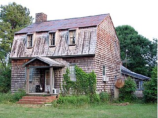
Person–McGhee Farm is a historic farm complex located at 5631 U.S. Highway 1 in Franklinton, Franklin County, North Carolina, about 4 miles north of town. The earliest section of the house was built sometime between 1770 and 1820, and is a three-bay, two-story frame dwelling over a stone-walled cellar. It has double shouldered brick end chimneys. In the 1890s, a large 2 1/2-story Queen Anne / Colonial Revival style section was added to the original Federal period dwelling. Also on the property are the contributing tenant house (1860s-1870s), a water tower, smokehouse, cattle barn, three log tobacco barns, and several sheds.

References

  1. Town of Franklinton - Latest News, Retrieved July 24, 2017.
  2. "ArcGIS REST Services Directory". United States Census Bureau. Retrieved September 20, 2022.
  3. 1 2 U.S. Geological Survey Geographic Names Information System: Franklinton, North Carolina
  4. 1 2 3 "U.S. Census website". United States Census Bureau . Retrieved January 16, 2015.
  5. Gannett, Henry (1905). The Origin of Certain Place Names in the United States. Govt. Print. Off. pp.  131.
  6. William S. Powell (1968). The North Carolina Gazetteer: A Dictionary of Tar Heel Places. Chapel Hill: University of North Carolina Press. p. 182. ISBN   0-8078-1247-1. Library of Congress Catalog Card #28-25916.
  7. 1 2 William E. King (1997). "Durham's Bid to Win Over Trinity College". If Gargoyles Could Talk: Sketches of Duke University. Carolina Academic Press . Retrieved November 19, 2012.
  8. William E. King (1997). "Trinity College Moves to Durham". If Gargoyles Could Talk: Sketches of Duke University. Carolina Academic Press . Retrieved November 19, 2012.
  9. "He was a Negro Soldier". The Wautauga Democrat. January 15, 1920.
  10. "Drags Negro to Death". New York Times. December 28, 1919.
  11. "Appendix I – Lynching Record for 1919". NAACP Annual Report. January 1919. p. 93. Retrieved November 3, 2015.
  12. 1 2 "National Register Information System". National Register of Historic Places . National Park Service. July 9, 2010.
  13. WRAL TV Channel 5, Franklin County Election Results – November 3, 2015, Retrieved November 3, 2015.
  14. National Arbor Day Foundation - Tree City USA Directory, Retrieved October 6, 2017.
  15. North Carolina Railroad Company, NC Rail Map, Retrieved November 10, 2022.
  16. North Carolina Railroads -- Louisburg Railroad, Retrieved February 14, 2022.
  17. Coleman, Alan (2008). Railroads of North Carolina. Arcadia Publishing. p. 51. ISBN   978-0-7385-5336-8., Retrieved February 14, 2022.
  18. National Register of Historic Places, Registration Form -- Franklinton Depot, Retrieved February 14, 2022.
  19. North Carolina Department of Transportation -- NCDOT Owned & Preserved Rail Corridors, Retrieved February 14, 2022.
  20. "Census of Population and Housing". Census.gov. Retrieved June 4, 2015.
  21. "Explore Census Data". data.census.gov. Retrieved December 23, 2021.
  22. Town of Franklinton - Board of Commissioners, Retrieved August 10, 2022.
  23. "Inventory of the Wilbur Wade Card Papers". University Archives, Duke University.
  24. John Macfie (1986). "Fuller, Thomas Oscar". NCpedia. Retrieved January 13, 2023.