Free State of Bottleneck

Last updated
Free State of Bottleneck
Freistaat Flaschenhals (German)
1919–1923
Flag of the Free State of Bottleneck.svg
Map of the Freistaat Flaschenhals (1919-1923).png
StatusUnoccupied territory within post-World War I Germany
Capital Lorch
Common languages German
Government Republic
President 
Historical era Interwar period
 Established
10 January 1919
  Abolished
23 February 1923
Population
 1920
17,363
Currency Freistaattaler
Preceded by
Succeeded by
Flagge Preussen - Provinz Hessen-Nassau.svg Province of Hesse-Nassau
Province of Hesse-Nassau Flagge Preussen - Provinz Hessen-Nassau.svg
Today part of Germany

The Free State of Bottleneck (German : Freistaat Flaschenhals) was a short-lived quasi-state that existed from 10 January 1919 until 25 February 1923. It was formed out of part of the Prussian province of Hesse-Nassau as a consequence of the occupation of the Rhineland following World War I. The Bottleneck is now part of the modern German states of Hesse and Rhineland-Palatinate.

Contents

Creation

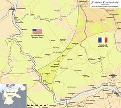
Following the Armistice of 1918, Allied forces occupied the German territory west of the Rhine. To maintain a military presence on the eastern side, the Allied powers extended their zones of occupation by creating three semi-circular bridgeheads of 30 km (19 mi) radius, radiating from Cologne (British zone), Koblenz (American zone), and Mainz (French zone).

The French and American zones did not meet entirely, leaving a narrow gap on the eastern side of the Rhine containing the Wisper valley, the towns of Lorch and Kaub, and villages of Lorchhausen, Sauerthal, Ransel, Wollmerschied, Welterod, Zorn, Strüth and Egenrod.

Surrounded by the two Allied bridgeheads, the Rhine to the south-west and no roads nor railways to speak of towards the north-east, this tiny region was effectively cut off from the rest of Germany and subsequently separated from the administration of the Weimar Republic.

Owing to the circular nature of the Allied bridgeheads, this enclosed territory took on the shape of a bottleneck, hence the name that was given to the microstate, when it was declared on 10 January 1919.

Life in the Bottleneck

Emergency money. The verse reads like, "Nowhere is a finer deck / than the 'Free State' Bottleneck". Notgeldschein Freistaat Flaschenhals 01.JPG
Emergency money. The verse reads like, "Nowhere is a finer deck / than the 'Free State' Bottleneck".

The region contained approximately 17,000 people and its largest town, Lorch, was established as its capital. The mayor of Lorch, Edmund Pnischeck, was subsequently elected as president of this small territory. Pnischeck headed the Bottleneck's administration for the time of its existence, which even oversaw the production of its own stamps and currency.

There were no roads connecting the Bottleneck to unoccupied Germany, trains were not permitted to stop there, and air or river transportation was impossible. The movement of goods and post to and from the state was only made possible by smuggling. Once, a French train loaded with coal from the Ruhr valley was hijacked from neighbouring Rüdesheim am Rhein and taken to the Bottleneck, where the coal was distributed among the populace for heating purposes. [1]

Foreign relations

The state issued its own passports to its citizens, and had plans to establish an embassy in Berlin. Furthermore, it was intended to establish diplomatic relations with other countries, but the state ceased to exist before these plans were realised. [2]

Abolition

After four years of existence, the Free State of Bottleneck was abolished on 23 February 1923 following the French Occupation of the Ruhr. The Bottleneck was eventually reincorporated with the Prussian province of Hesse-Nassau.

The Bottleneck today

The territory that formerly comprised the Bottleneck is now part of the Rhine Gorge UNESCO World Heritage Site. The history of the Bottleneck is now a tourist attraction in the area, particularly in the former Free State's major towns of Kaub and Lorch.

Bottleneck stamps and currency are now sought-after rarities. Wine that was smuggled in from occupied Germany and stored in Lorch and Kaub can also fetch high prices.

See also

Related Research Articles

<span class="mw-page-title-main">Rhineland-Palatinate</span> State in Germany

Rhineland-Palatinate is a western state of Germany. It covers 19,846 km2 (7,663 sq mi) and has about 4.05 million residents. It is the ninth largest and sixth most populous of the sixteen states. Mainz is the capital and largest city. Other cities are Ludwigshafen am Rhein, Koblenz, Trier, Kaiserslautern, Worms and Neuwied. It is bordered by North Rhine-Westphalia, Saarland, Baden-Württemberg and Hesse and by France, Luxembourg and Belgium.

<span class="mw-page-title-main">Westphalia</span> State part and historic region of North Rhine-Westphalia, Germany

Westphalia is a region of northwestern Germany and one of the three historic parts of the state of North Rhine-Westphalia. It has an area of 20,210 square kilometres (7,800 sq mi) and 7.9 million inhabitants.

<span class="mw-page-title-main">Palatinate (region)</span> Historical region of Germany

The Palatinate, or the Rhenish Palatinate (Rheinpfalz), is a historical region of Germany. Prior to World War II, it was also referred to as Rhenish Bavaria; as a state of the Holy Roman Empire, it was known as the Lower Palatinate (Unterpfalz), which designated only the western part of the Electorate of the Palatinate, as opposed to the Upper Palatinate (Oberpfalz). It occupies roughly the southernmost quarter of the German federal state of Rhineland-Palatinate (Rheinland-Pfalz), covering an area of 2,105 square miles (5,450 km2) with about 1.4 million inhabitants. Its residents are known as Palatines (Pfälzer).

<span class="mw-page-title-main">Rhineland</span> Historic region of Germany

The Rhineland is a loosely defined area of Western Germany along the Rhine, chiefly its middle section.

<span class="mw-page-title-main">History of Hesse</span>

This article is about the history of Hesse. Hesse is a state in Germany.

<span class="mw-page-title-main">Provinces of Prussia</span> Overview of the Provinces in Prussia

The Provinces of Prussia were the main administrative divisions of Prussia from 1815 to 1946. Prussia's province system was introduced in the Stein-Hardenberg Reforms in 1815, and were mostly organized from duchies and historical regions. Provinces were divided into several Regierungsbezirke, sub-divided into Kreise (districts), and then into Gemeinden (townships) at the lowest level. Provinces constituted the highest level of administration in the Kingdom of Prussia and Free State of Prussia until 1933, when Nazi Germany established de facto direct rule over provincial politics, and were formally abolished in 1946 following World War II. The Prussian provinces became the basis for many federal states of Germany, and the states of Brandenburg, Lower Saxony, and Schleswig-Holstein are direct successors of provinces.

<span class="mw-page-title-main">Saar Protectorate</span> French protectorate, disputed territory

The Saar Protectorate, officially Saarland, was a French protectorate and a disputed territory separated from Germany. On joining the Federal Republic of Germany in 1957, it became the smallest "federal state", the Saarland, not counting the "city states" of Berlin, Hamburg, and Bremen. It is named after the Saar River.

<span class="mw-page-title-main">Rhine Province</span> Former province of the Kingdom of Prussia and the Free State of Prussia

The Rhine Province, also known as Rhenish Prussia or synonymous with the Rhineland, was the westernmost province of the Kingdom of Prussia and the Free State of Prussia, within the German Reich, from 1822 to 1946. It was created from the provinces of the Lower Rhine and Jülich-Cleves-Berg. Its capital was Koblenz and in 1939 it had 8 million inhabitants. The Province of Hohenzollern was militarily associated with the Oberpräsident of the Rhine Province. Also, for a short period of time, the Province of Hohenzollern was indirectly and de-facto controlled by the Rhine Province.

<span class="mw-page-title-main">Middle Rhine</span> River in Germany

Between Bingen and Bonn, Germany, the river Rhine flows as the Middle Rhine through the Rhine Gorge, a formation created by erosion, which happened at about the same rate as an uplift in the region, leaving the river at about its original level, and the surrounding lands raised. This gorge is quite deep, about 130 metres (430 ft) from the top of the rocks down to the average water-line.

<span class="mw-page-title-main">Kaub</span> Town in Rhineland-Palatinate, Germany

Kaub is a town in Germany, state Rhineland-Palatinate, district Rhein-Lahn-Kreis. It is part of the municipality (Verbandsgemeinde) Loreley. It is located on the right bank of the Rhine, approx. 50 km west from Wiesbaden. It is connected to Wiesbaden and Koblenz by railway. It has a Roman Catholic and an Evangelical church, and a statue of General Blücher. Historically, trade mainly consisted of the wines of the district.

<span class="mw-page-title-main">People's State of Hesse</span> State of Hesse (1918–1945)

The People's State of Hesse was one of the constituent states of Germany from 1918 to 1945, as the successor to the Grand Duchy of Hesse after the defeat of the German Empire in World War I, on the territory of the current German states of Hesse and the Rhineland-Palatinate. The State was established after Grand Duke Ernest Louis was deposed on 9 November 1918. The term "People's State" referred to the fact that the new state was a Republic and was used in the same manner as the term Free State, which was employed by most of the other German States in this period.

<span class="mw-page-title-main">Greater Hesse</span> Provisional name for a section of German territory

Greater Hesse was the provisional name given for a section of German territory created by the United States military administration in at the end of World War II. It was formed by the Allied Control Council on 19 September 1945 and became the modern German state of Hesse on 1 December 1946.

<span class="mw-page-title-main">Rhenish Republic</span> Short lived republic in the Rhineland

The Rhenish Republic was proclaimed at Aachen (Aix-la-Chapelle) in October 1923 during the occupation of the Ruhr by troops from France and Belgium and subjected itself to French protectorate. It comprised three territories, named North, South and Ruhr. Their regional capitals were, respectively, Aachen, Koblenz and Essen.

<span class="mw-page-title-main">Braunshorn</span> Municipality in Rhineland-Palatinate, Germany

Braunshorn is an Ortsgemeinde – a municipality belonging to a Verbandsgemeinde, a kind of collective municipality – in the Rhein-Hunsrück-Kreis (district) in Rhineland-Palatinate, Germany. It belongs to the Verbandsgemeinde of Kastellaun, whose seat is in the like-named town.

<span class="mw-page-title-main">Occupation of the Rhineland</span> 1918–1930 occupation by the WWI Allies

The Occupation of the Rhineland placed the region of Germany west of the Rhine river and four bridgeheads to its east under the control of the victorious Allies of World War I from 1 December 1918 until 30 June 1930. The occupation was imposed and regulated by articles in the Armistice of 11 November 1918, the Treaty of Versailles and the parallel agreement on the Rhineland occupation signed at the same time as the Versailles Treaty. The Rhineland was demilitarised, as was an area stretching fifty kilometres east of the Rhine, and put under the control of the Inter-Allied Rhineland High Commission, which was led by a French commissioner and had one member each from Belgium, Great Britain and the United States. The purpose of the occupation was to give France and Belgium security against any future German attack and serve as a guarantee for Germany's reparations obligations. After Germany fell behind on its payments in 1922, the occupation was expanded to include the industrial Ruhr valley from 1923 to 1925.

The Inter-Allied Rhineland High Commission was created by the Treaty of Versailles on 28 June 1919, to supervise the occupation of the Rhineland and "ensure, by any means, the security and satisfaction of all the needs of the Armies of Occupation". It came into being on 10 January 1920, when the treaty came into force. It was based in Coblenz.

<span class="mw-page-title-main">Aar Valley Railway</span>

The Aar Valley Railway is a 53.7 km long line between Wiesbaden, the capital of the German state of Hesse, and Diez in Rhineland-Palatinate. From 1985 to 2009, the southern end was operated as a heritage railway with historic trains. The Hessian part of the line is heritage-listed. Currently, two bridges are unusable and several sets of points are defective and need to be repaired. Its northern end is operated with draisines.

In the London Protocol signed on 12 September 1944, the Allies of World War II agreed on dividing Germany into three occupation zones after the war.

The abolition of Prussia took place on 25 February 1947 through a decree of the Allied Control Council, the governing body of post-World War II occupied Germany and Austria. The rationale was that by doing away with the state that had been at the center of German militarism and reaction, it would be easier to preserve the peace and for Germany to develop democratically.

<span class="mw-page-title-main">Reich Ministry for the Occupied Territories</span> Weimar Germany ministry

The Reich Ministry for the Occupied Territories was a cabinet-level ministry of the Weimar Republic from 24 August 1923 to 30 September 1930. It was responsible for the administration of both the Rhineland region occupied by the Allies under the terms of the Treaty of Versailles and of the Ruhr after it was occupied by the French and Belgians in January 1923. The Ministry is not to be confused with Reich Ministry for the Occupied Eastern Territories that existed under the National Socialists.

References

  1. ""Official" website of the Free State of Bottleneck". Archived from the original on 2012-02-07. Retrieved 2007-05-03.[ dead link ]
  2. (in German) Lebendige Geschichte: Vor 80 Jahren: der Freistaat Flaschenhals Archived 2006-03-05 at archive.today Hessischer Rundfunk

50°09′43″N7°55′16″E / 50.16194°N 7.92111°E / 50.16194; 7.92111