Gallery
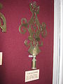 Templecombe Friendly Society Brass on display in Wells and Mendip Museum
 Chilcompton and Butleigh Friendly Societies Brasses
 Bishops Lydeard and Goathurst Friendly Society Brasses
Friendly society brasses were the emblems of village friendly societies or clubs common in the west of England between the late 18th and early 20th centuries. The use of brasses as emblems was particularly prevalent in Somerset and the surrounding counties. [1]
On the society's annual feast day or walking day, usually in spring, the members would hold a parade around the village, with the officers or sometimes all the members carrying poles or staves between four and eight feet (1.2 to 2.4 meters) in length and usually painted. [2] Some poles (also known as rods, wands or 'club sticks') were headed by garlands of flowers, [3] while in the West Country, the poles were commonly headed by a brass finial with a distinctive shape and decorated with ribbons.
It is thought that the use of brass was due to the proximity of the brass industries in Bristol and Bridgwater, [4] [5] [6] and the two separate manufacturing centres may account for there being two principal forms of brass pole-head. Those used north and east of a line drawn between Bridgwater and Yeovil were generally flat and cut from sheet brass, while those south and west of the line were more three-dimensional. [7] The flat Brasses most commonly took the form of an elaborate spear-head or a fleur-de-lis, [8] while the three-dimensional forms were cast and based on a ball or column shape.
There was often a symbolic element in a brass emblem. For example, the addition of a crown could indicate loyalty to the monarchy, while an acorn or oak leaves indicated strength or longevity. [5] Other symbols include clasped hands or two figures shaking hands indicating friendship and community, [9] religious symbols such as anchors or the Agnus Dei, [10] and horseshoes. [11] Some Brasses may replicate the sign of the inn where the Society met. [12]
Stave dances may have been dances performed after the procession, with the dancers carrying and using the staves with their brass heads in the course of the dance, for example to form arches or stars. There are few records of the dances themselves, but some from Somerset, and from Stourton Caundle and Fifehead Magdalen in Dorset, have been found. [6] Some modern-day Morris dance groups have revived stave dancing, for example 'Somerset Morris' based near Bristol, [13] and the 'Mendip Stave Dancers' from Oakhill in Somerset. [14]


Cheddar is a large village and civil parish in the English county of Somerset. It is situated on the southern edge of the Mendip Hills, 9 miles (14 km) north-west of Wells, 11 miles (18 km) south-east of Weston-super-Mare and 18 miles (29 km) south-west of Bristol. The civil parish includes the hamlets of Nyland and Bradley Cross. The parish had a population of 5,755 in 2011 and an acreage of 8,592 acres (3,477 ha) as of 1961.

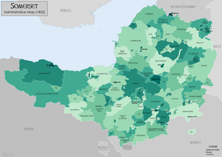
Somerset is a ceremonial county in South West England. It is bordered by the Bristol Channel, Gloucestershire, and Bristol to the north, Wiltshire to the east and the north-east, Dorset to the south-east, and Devon to the south-west. The largest settlement is the city of Bath, and the county town is Taunton.

Bridgwater is a historic market town and civil parish in Somerset, England. The town had a population of 41,276 at the 2021 Census. Bridgwater is at the edge of the Somerset Levels, in level and well-wooded country. The town lies along both sides of the River Parrett; it has been a major inland port and trading centre since the industrial revolution. Most of its industrial bases still stand today. Its larger neighbour, Taunton, is linked to Bridgwater via a canal, the M5 motorway and the GWR railway line.

Glastonbury is a town and civil parish in Somerset, England, situated at a dry point on the low-lying Somerset Levels, 23 miles (37 km) south of Bristol. The town had a population of 8,932 in the 2011 census. Glastonbury is less than 1 mile (2 km) across the River Brue from Street, which is now larger than Glastonbury.
Shepton Mallet is a market town and civil parish in Somerset, England, some 16 miles (26 km) south-west of Bath, 18 miles (29 km) south of Bristol and 5 miles (8.0 km) east of Wells. It had an estimated population of 10,810 in 2019. Mendip District Council was based there. The Mendip Hills lie to the north and the River Sheppey runs through the town, as does the route of the Fosse Way, the main Roman road between north-east and south-west England. There is evidence of Roman settlement. Its listed buildings include a medieval parish church. Shepton Mallet Prison was England's oldest, but closed in March 2013. The medieval wool trade gave way to trades such as brewing in the 18th century. It remains noted for cider production. It is the closest town to the Glastonbury Festival and nearby the Royal Bath and West of England Society showground.

The Somerset Levels are a coastal plain and wetland area of Somerset, England, running south from the Mendips to the Blackdown Hills.

Nether Stowey is a large village in Somerset, South West England. It sits in the foothills of the Quantock Hills, just below Over Stowey. The parish of Nether Stowey covers approximately 4 km2, with a population of 1,373.

The Mendip Hills is a range of limestone hills to the south of Bristol and Bath in Somerset, England. Running from Weston-super-Mare and the Bristol Channel in the west to the Frome valley in the east, the hills overlook the Somerset Levels to the south and the Chew Valley and other tributaries of the Avon to the north. The highest point, at 325 metres above sea level, is Beacon Batch which is the summit area atop Black Down. The hills gave their name to the former local government district of Mendip, which administered most of the local area until April 2023. The higher, western part of the hills, covering 198 km2 (76 sq mi) has been designated an Area of Outstanding Natural Beauty (AONB), which gives it a level of protection comparable to a national park.

A friendly society is a mutual association for the purposes of insurance, pensions, savings or cooperative banking. It is a mutual organization or benefit society composed of a body of people who join together for a common financial or social purpose. Before modern insurance and the welfare state, friendly societies provided financial and social services to individuals, often according to their religious, political, or trade affiliations. These societies are still widespread in many parts of the developing world, where they are referred to as ROSCAs, ASCAs, burial societies, chit funds, etc.

Axbridge is a town in Somerset, England, on the River Axe, near the southern edge of the Mendip Hills. Its population according to the 2011 census was 2,057.
Somerset is a historic county in the south west of England. There is evidence of human occupation since prehistoric times with hand axes and flint points from the Palaeolithic and Mesolithic eras, and a range of burial mounds, hill forts and other artefacts dating from the Neolithic, Bronze and Iron Ages. The oldest dated human road work in Great Britain is the Sweet Track, constructed across the Somerset Levels with wooden planks in the 39th century BCE.

Ebbor Gorge is a limestone gorge in Somerset, England, designated and notified in 1952 as a 63.5-hectare (157-acre) biological Site of Special Scientific Interest in the Mendip Hills. It was donated to the National Trust in 1967 and is now managed by Natural England as a national nature reserve.

The West Country Carnival Circuits are an annual celebration featuring a parade of illuminated carts in the English West Country. The celebration dates back to the Gunpowder Plot of 1605. The purpose is to raise money for local charities.

Westbury-sub-Mendip is a village and civil parish in Somerset, England. The village is on the southern slopes of the Mendip Hills, 4 miles (6.4 km) from Wells and Cheddar.

Somerset is a county in the south west of England. It has a varied cultural tradition ranging from the Arthurian legends to The Wurzels, a band specialising in Scrumpy and Western music.

The Grade I listed buildings in Somerset, England, demonstrate the history and diversity of its architecture. The ceremonial county of Somerset consists of a non-metropolitan county, administered by Somerset County Council, which is divided into five districts, and two unitary authorities. The districts of Somerset are West Somerset, South Somerset, Taunton Deane, Mendip and Sedgemoor. The two administratively independent unitary authorities, which were established on 1 April 1996 following the breakup of the county of Avon, are North Somerset and Bath and North East Somerset. These unitary authorities include areas that were once part of Somerset before the creation of Avon in 1974.

The earliest known infrastructure for transport in Somerset is a series of wooden trackways laid across the Somerset Levels, an area of low-lying marshy ground. To the west of this district lies the Bristol Channel, while the other boundaries of the county of Somerset are along chains of hills that were once exploited for their mineral deposits. These natural features have all influenced the evolution of the transport network. Roads and railways either followed the hills, or needed causeways to cross the Levels. Harbours were developed, rivers improved, and linked to sources of traffic by canals. Railways were constructed throughout the area, influenced by the needs of the city of Bristol, which lies just to the north of Somerset, and to link the ports of the far south-west with the rest of England.

The county of Somerset is in South West England, bordered by the Bristol Channel and the counties of Bristol and Gloucestershire to the north, and Wiltshire to the east, Dorset to the south, and Devon to the west. The climate, influenced by its proximity to the Atlantic Ocean and the prevailing westerly winds, tends to be mild, damp and windy.

Stave dancing is a style of folk dance from the south-west of England, especially Somerset, Dorset, and Wiltshire. Teams of dancers carry long decorated poles, known as staves, over their shoulders whilst performing. Having effectively died-out in the 1920s, interest in the style revived in the 1980s, and today a number of Morris and country dancing teams perpetuate the tradition. Some claim the tradition's origins lie in the annual ‘club-walks’ of the friendly societies.