Frisian Islands

Last updated
Frisian Islands
Waddeneilanden.PNG
The Wadden Islands archipelago, including the Frisian Islands
Frisian Islands
Geography
Area1,047.49 km2 (404.44 sq mi)
Administration
Demographics
Population81,341

The Frisian Islands, also known as the Wadden Islands or the Wadden Sea Islands, form an archipelago at the eastern edge of the North Sea in northwestern Europe, stretching from the northwest of the Netherlands through Germany to the west of Denmark. The islands shield the mudflat region of the Wadden Sea (large parts of which fall dry during low tide) from the North Sea.

Contents

The Frisian Islands, along with the mainland coast in the German Bight, form the region of Frisia (German and Dutch: Friesland), homeland of the Frisian people. Generally, the term Frisian Islands is used for the islands where Frisian is spoken and the population is ethnically Frisian. In contrast, the term Wadden Islands applies to the entire archipelago, including the Dutch-speaking westernmost islands of Texel and Vlieland and Danish-speaking Danish Wadden Sea Islands further north off the west coast of Jutland.

Most of the Frisian Islands are environmentally protected areas, and an international wildlife nature reserve is being coordinated between the Netherlands, Germany and Denmark. Natural gas and oil drilling continue, however, and in the vicinity of the Ems, Weser and Elbe estuaries, and ship traffic causes tension between wildlife protection and economic values.

History

Origins

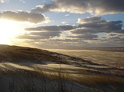
During the last ice age, which ended approximately 12,000 years ago, sea level was about 60 metres (200 ft) lower than it is now, and part of what is now the North Sea was dry land. With the melting of the ice caps, the sea level rose, reaching the current coast line around the beginning of the Holocene era, approximately 7,000 years ago. Tidal action transported large quantities of sand to form a line of dunes extending over 500 kilometres (310 mi) from the Netherlands to the mouth of the river Elbe in Germany. The sea broke through the dunes in many places to form the Wadden Islands, with the low-lying country behind becoming the tidal Wadden mudflats.

Island forming

The Dutch West Frisian and the German East Frisian Islands are barrier islands. [1] They arose along the breakers' edge where the water surge piled up sediment, and behind which sediment was carried away by the breaking waves. Over time, shoals arose, which ultimately were only covered by infrequent storm floods. [1] Once plants began to colonize the sandbanks, the land began to stabilize. [2]

In contrast, the North Frisian Islands arose from the remains of old Geestland islands, where the land was partially removed by storm floods and water action and then separated from the mainland. They are, therefore, often higher and their cores are less exposed to changes than the islands to the south. Beyond the core, however, the same processes are at work, as is particularly evident on Sylt, where the south of the island threatens to be broken away and the harbour at List in the north silts up. [3] The Danish Islands, the next in the chain to the north, arose from sandbanks. Into the 20th century, silt on the islands was a serious problem. To protect them, small woods were planted.

Habitation

Long before the beginning of the modern era, there were already humans inhabiting the Wadden area. Up to 800 AD, most inhabitants lived on terpen (artificial mounds). Living conditions were difficult. The Roman naturalist Pliny, writing in the first century AD, described the Frisians as ...

... people who live without trees or shrubs. ... in the east, to the coasts of the ocean, a number of races in such needy conditions exist; but this also applies to the races of peoples which are called the large and small Chaucen, which we have seen in the north. There, two times in each period of a day and a night, the ocean with a fast tide submerges an immense plain, thereby the hiding ... whether the area is sea or land. There this miserable race inhabits raised pieces ground or platforms, which they have moored by hand above the level of the highest known tide. Living in huts built on the chosen spots, they seem like sailors in ships if water covers the surrounding country, but like shipwrecked people when the tide has withdrawn itself, and around their huts they catch fish which try to escape with the expiring tide. It is for them not possible to keep herds and live on milk such as the surrounding tribes. They cannot even fight with wild animals, because all the bush country lies too far away. They braid ropes of sedges and rushes from the marshes with which they make nets to be able to catch fish, and they dig up mud with their hands and dry it more in wind than in the sun, and with soil as fuel they heat their food and their own bodies, frozen in northern wind. Their only drink comes from storing rain water in tanks front of their houses. And these are the races which, if they were now conquered by the Roman nation, say that they will fall into slavery! It is only too true: Destiny saves people as a punishment. [4]

Around 1000AD, dike construction began. Monks were instrumental in this activity, among others those of the monastery of Aduard. But earlier attempts had been undertaken to dam the sea. At the Frisian Peins (near Franeker), a 40-meter section of dike has been discovered that is thought to date from the 1st or 2nd century BC.

In the late Middle Ages, the dike system was gradually strengthened and flooding diminished. Beginning in the 17th century, dikes were built further out to reclaim more land. This activity peaked in the 19th and 20th centuries.

Conservation of the West Frisian/Dutch coast

The dunes south of the Wadden Sea were also liable to this process, but human intervention prevented the many storm surges from changing the coast of the provinces North Holland and South Holland into separate islands with Wadden mudflats behind them. However, around 1200AD, storm surges did break up the northern coast of Western Friesland into five islands. Around 1600AD, four of these along the West coast had been again recovered, but Wieringen, to the south-east of Texel, remained an island up to the 20th century.

Archaeology

In 2019, Dutch maritime investigators unearthed a 16th century shipwreck during a search for containers from MSC Zoe. According to Holland’s National Office for Cultural Heritage, the ship was built circa 1540 in the Netherlands during the reign of Charles V. Researchers also found copper plates with emblem of the Fugger family and wooden beams with a sleek hull about 30 metres long. [5] [6] [7]

Embankment of the mudflat

In Friesland and Groningen plans were made to embank and drain the Wadden Sea. As a result, the islands would have become part of the mainland. As of today, nature and environmental movements have been able to prevent this.

The only plan ever to be carried out was the construction of a causeway from the Frisian Holwerd to Ameland, in 1872, which was not very successful. Shortly after construction, the causeway had already suffered so much storm damage that the dam was abandoned in 1882. The dam has been almost entirely eroded since then.

In the northern Wadden Sea building dams proved to be considerably simpler. Nordstrand is now so much linked to the rampart by dikes that it is difficult to define it as an island, and also Langeness, Oland, Nordstrandischmoor, Hamburger Hallig, Sylt, and Rømø are all reachable by dams. Mandø is even reachable without a dam by means of tidal road.

Development

Migration

The Wadden Islands are in continuous apparent movement. The most important movement is the 'migration': the islands themselves are slowly but certainly moving from West to East. On the West side most of the islands disappear slowly into the sea and on the East side even larger sand-banks arise. This movement is also the reason that most of the villages themselves are on the West side of their island. When they were founded they were situated in the center. Over the course of the last few centuries, many houses and even entire villages disappeared into the sea.

Hook shaping

The second movement is the development of a hook shape. Along the sea breaches hook-shaped sand ridges arise, which change form with the moving of the sea arm. By growth of these hooks new shoals arise such as the Noorderhaaks and Zuiderhaaks. Sometimes such a shoal grows, originating where an island has been 'walking', and the island regains area.

Islands

Dutch Wadden Islands

Aerial view of Oudeschild on Texel Oudeschildaerial.JPG
Aerial view of Oudeschild on Texel

(from West to East)

Inhabited

The Dutch islands have a surface of 405.2 km² and a total of 23,872 inhabitants.

Uninhabited

The names of all these places suggest this is the transition area between island and shoal (plaat in Dutch). Noorderhaaks, Rottumerplaat and Rottumeroog are generally considered to be islands, the others are considered to be sandbars and disappear from time to time into the waves. The former island of Wieringen can be found at the top of North Holland, against the Afsluitdijk.

German Wadden Islands

(from West to East and South to North)

Aerial view of Sylt Luftaufnahmen Nordseekueste 2012-05-by-RaBoe-119.jpg
Aerial view of Sylt

Inhabited

Baltrum and Langeoog Baltrum and Langeoog, Germany.jpg
Baltrum and Langeoog

Uninhabited

Suderoogsand, Norderoogsand, Japsand (uninhabited shoals or sand bars, left and center), and Amrum (top), with Pellworm and Fohr (green areas) at the right Suderoogsand, Norderoogsand, Japsand, and Amrum.jpg
Süderoogsand, Norderoogsand, Japsand (uninhabited shoals or sand bars, left and center), and Amrum (top), with Pellworm and Föhr (green areas) at the right

The German islands have a surface of 448.52 km² (173 sq. mi.) and 53,296 inhabitants. It is possible to make a boat excursion from several German Wadden Islands to the small rock island of Helgoland which is situated 70 km (43 mi) off the German coast. Although Heligoland (German: Helgoland) is not a Wadden Island, there are strong cultural links with the Wadden area; for example a dialect of North Frisian is spoken there.

Not all these islands are officially considered to be Wadden Islands. For the definition of an island, a minimum of 160 hectares (0.6 sq. mi.) must no longer be submerged during average high water by the North Sea.

Danish Wadden Islands

(from South to North)

In the 20th century, south of the Danish island Rømø lay the small island Jordsand, which sank in 1999. North of the Danish island Fanø the sand coast has been opened and closed numerous times in the course of history, but at the moment the coast line is closed, and forms a whole again except for two west coast fjords. The Danish islands have a total surface of 193.8 km² (74.5 sq. mi.) and 4,173 inhabitants.

Related Research Articles

<span class="mw-page-title-main">Wadden Sea</span> An intertidal zone in the southeastern part of the North Sea (Netherlands, Germany and Denmark)

The Wadden Sea is an intertidal zone in the southeastern part of the North Sea. It lies between the coast of northwestern continental Europe and the range of low-lying Frisian Islands, forming a shallow body of water with tidal flats and wetlands. It has a high biological diversity and is an important area for both breeding and migrating birds. In 2009, the Dutch and German parts of the Wadden Sea were inscribed on UNESCO's World Heritage List and the Danish part was added in June 2014.

<span class="mw-page-title-main">Sylt</span> German island in the North Sea

Sylt is a former island in northern Germany, part of Nordfriesland district, Schleswig-Holstein, well known for the distinctive shape of its shoreline. It belongs to the North Frisian Islands and is the largest island in North Frisia. The northernmost island of Germany, it is known for its tourist resorts, notably Westerland, Kampen and Wenningstedt-Braderup, as well as for its 40-kilometre-long (25-mile) sandy beach. It is frequently covered by the media in connection with its exposed situation in the North Sea and its ongoing loss of land during storm tides. Since 1927, Sylt has been connected to the mainland by the Hindenburgdamm causeway. In later years, it has been a resort for the German jet set and tourists in search of occasional celebrity sightings.

<span class="mw-page-title-main">Ameland</span> Municipality and island of the Netherlands

Ameland is a municipality and one of the West Frisian Islands off the north coast of the Netherlands. It consists mostly of sand dunes and is the third major island of the West Frisians. It neighbours islands Terschelling to the west and Schiermonnikoog to the east. This includes the small Engelsmanplaat and Rif sandbanks to the east.

<span class="mw-page-title-main">North Frisian Islands</span>

The North Frisian Islands are the Frisian Islands off the coast of North Frisia.

<span class="mw-page-title-main">Vlieland</span> Municipality in Friesland, Netherlands

Vlieland is a municipality and island in the northern Netherlands. The municipality of Vlieland is the second most sparsely populated municipality in the Netherlands, after Schiermonnikoog.

<span class="mw-page-title-main">Texel</span> Municipality and island in North Holland, Netherlands

Texel is a municipality and an island with a population of 13,643 in North Holland, Netherlands. It is the largest and most populated island of the West Frisian Islands in the Wadden Sea. The island is situated north of Den Helder, northeast of Noorderhaaks, and southwest of Vlieland.

<span class="mw-page-title-main">East Frisian Islands</span> Chain of German islands in the North Sea

The East Frisian Islands are a chain of islands in the North Sea, off the coast of East Frisia in Lower Saxony, Germany. The islands extend for some 90 kilometres (56 mi) from west to east between the mouths of the Ems and Jade / Weser rivers and lie about 3.5 to 10 km offshore. Between the islands and the mainland are extensive mudflats, known locally as Watten, which form part of the Wadden Sea. In front of the islands are Germany's territorial waters, which occupy a much larger area than the islands themselves. The islands, the surrounding mudflats and the territorial waters form a close ecological relationship. The island group makes up about 5% of the Lower Saxony Wadden Sea National Park.

<span class="mw-page-title-main">Wadden Sea National Parks</span>

The Wadden Sea National Parks in Denmark, Germany and the Netherlands are located along the German Bight of the North Sea. In Germany and Denmark they also mark the area of the UNESCO World Heritage Site of the Wadden Sea. Divided from each other by administrative borders, they form a single ecological entity. The purpose of the national parks is the protection of the Wadden Sea ecoregion.

<span class="mw-page-title-main">Schleswig-Holstein Wadden Sea National Park</span> National Park in Schleswig-Holstein, Germany

The Schleswig-Holstein Wadden Sea National Park is a national park in the Schleswig-Holstein area of the German Wadden Sea. It was founded by the Parliament of Schleswig-Holstein on 1 October 1985 by the National Park Act of 22 July 1985 and expanded significantly in 1999. Together with the Lower Saxon Wadden Sea National Park, the Hamburg Wadden Sea National Park and those parts of Elbe estuary which are not nature reserves, it forms the German part of the Wadden Sea.

<span class="mw-page-title-main">Amrum</span> German island

Amrum is one of the North Frisian Islands on the German North Sea coast, south of Sylt and west of Föhr. It is part of the Nordfriesland district in the federal state of Schleswig-Holstein and has approximately 2,300 inhabitants.

<span class="mw-page-title-main">German Bight</span> Geographic feature along the coasts of Denmark, Germany, and the Netherlands

The German Bight is the southeastern bight of the North Sea bounded by the Netherlands and Germany to the south, and Denmark and Germany to the east. To the north and west it is limited by the Dogger Bank. The Bight contains the Frisian and Danish Islands. The Wadden Sea is approximately ten to twelve kilometres wide at the location of the German Bight. The Frisian islands and the nearby coastal areas are collectively known as Frisia. The southern portion of the bight is also known as the Heligoland Bight. Between 1949 and 1956 the BBC Sea Area Forecast used "Heligoland" as the designation for the area now referred to as German Bight.

<span class="mw-page-title-main">Mandø</span> Danish Wadden Sea island

Mandø or Manø is one of the Danish Wadden Sea islands off the southwest coast of Jutland, Denmark in the Wadden Sea, part of the North Sea. The island covers an area of 7.63 square kilometres and had between 27-31 inhabitants in January 2022. The island is part of Esbjerg Municipality and is situated approximately 12 kilometres southwest of the ancient town of Ribe.

<span class="mw-page-title-main">Wangerooge</span> Municipality in Lower Saxony, Germany

Wangerooge is one of the 32 Frisian Islands in the North Sea located close to the coasts of the Netherlands, Germany and Denmark. It is also a municipality in the district of Friesland in Lower Saxony in Germany.

<span class="mw-page-title-main">Mudflat hiking</span>

Mudflat hiking is a recreation enjoyed in the Netherlands, northwest Germany, Denmark, England and France. Mudflat hikers are people who, with the aid of a tide table, use a period of low water to walk and wade on the watershed of the mudflats, especially from the Frisian mainland coast to the Frisian islands.

<span class="mw-page-title-main">Danish Wadden Sea Islands</span>

The Danish Wadden Sea Islands are a group of islands on the western coast of Jutland, Denmark. They have belonged to the region of Southern Denmark since January 1, 2007. Previously they belonged to the counties of South Jutland and Ribe.

<span class="mw-page-title-main">North Frisian Barrier Island</span>

North Frisian Barrier Island is the collective term for three barrier islands due west of the German Halligen in the North Frisian Islands archipelago. The shoals act as natural breakwater for the Halligen and other islands closer to land. Uninhabited, they remain one of the few areas in the Wadden Sea that are unaffected by direct human activity.

<span class="mw-page-title-main">Rantum</span> Ortsteil of Sylt in Schleswig-Holstein, Germany

Rantum is a village and a former municipality on the island of Sylt in the district of Nordfriesland, in Schleswig-Holstein, Germany. Since 1 January 2009, it has been an Ortsteil (part) of the municipality Sylt.

<span class="mw-page-title-main">Wenningstedt-Braderup</span> Municipality in Schleswig-Holstein, Germany

Wenningstedt-Braderup is a municipality and seaside resort on the island of Sylt in the district of Nordfriesland, in Schleswig-Holstein, Germany. It is located north of the town of Westerland and is part of the Amt Landschaft Sylt. The local economy is dominated by tourism.

<span class="mw-page-title-main">Holwert</span> Village in Friesland, Netherlands

Holwert is a village in Noardeast-Fryslân municipality in the northern Netherlands, in the province of Friesland. It had a population of around 1,607 in January 2017. Before 2019, the village was part of the Dongeradeel municipality.

<span class="mw-page-title-main">Lower Saxon Wadden Sea National Park</span> National Park in Lower Saxony, Germany

The Lower Saxon Wadden Sea National Park was established in 1986 and embraces the East Frisian Islands, mudflats and salt marshes between the Bay of Dollart on the border with the Netherlands in the west and Cuxhaven as far as the Outer Elbe shipping channel in the east. The national park has an area of about 345,800 hectares (1,335 sq mi). The National Park organisation is located in Wilhelmshaven. In June 2009, the National Park became a UNESCO World Heritage Site along with the Schleswig-Holstein Wadden Sea and the Dutch Wadden Sea, highlighting its unique intertidal ecosystem and high biodiversity.

References

  1. 1 2 Velde, Bruce; Gleb Nikolaevich Baturin; George V. Chilingar; Karl H. Wolf (1988). "Control of Barrier Island shape by inlet sediment bypassing: East Frisian Islands, West Germany (Abstract) Fitzgerald, Duncan M., Penland Shea and Nummedal, Dag". Phosphorites on the Sea Floor. Vol. Marine Geology, 60 (1984) 355-376. Elsevier. p. 365. ISBN   978-0-444-42400-6.
  2. "North Frisian Islands". WorldAtlas.com. 2007. Retrieved 2007-07-24.
  3. Ahrendt, Kai. "Expected Effects of Climatic Change on a Barrier Island - Case Study Sylt Island/German Bight" (PDF). Retrieved 2007-07-24.
  4. Pliny the Elder. Naturalis historia, book 16,2.
  5. "Dutch container search reveals rare ancient shipwreck - CNA". 2019-04-03. Archived from the original on 2019-04-03. Retrieved 2020-08-08.
  6. "Dutch container search reveals rare ancient shipwreck". The Jakarta Post. Retrieved 2020-08-08.
  7. Rogers, James (2019-04-04). "Search for lost sea containers leads to discovery of 16th-century Dutch shipwreck". Fox News. Retrieved 2020-08-08.

53°57′N8°30′E / 53.950°N 8.500°E / 53.950; 8.500