
Reynolda Village is a shopping and business complex in Winston-Salem, North Carolina, created from the servant and agricultural buildings of Reynolda, the former R. J. Reynolds estate. The village, which covers around 13.5 acres (5.5 ha), was planned as a working model farm, designed by Charles Barton Keen and Willard C. Northup in the early 20th century. It is now part of Reynolda Historic District, with twenty-two of its buildings, and one other contributing structure, now listed on the National Register of Historic Places.

Genesee Depot is a small unincorporated community in Waukesha County, Wisconsin, United States. It is in the Town of Genesee, in southeastern Wisconsin between Milwaukee and Madison, and named for the train station, or depot, of the Wisconsin and Calumet Railroad that formerly served the town.
Pimento is an unincorporated community in Linton Township, Vigo County, in the U.S. state of Indiana. It is part of the Terre Haute Metropolitan Statistical Area.

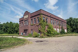
The Georgia State Railroad Museum is a museum in Savannah, Georgia located at a historic Central of Georgia Railway site. It includes parts of the Central of Georgia Railway: Savannah Shops and Terminal Facilities National Historic Landmark District. The complex is considered the most complete antebellum railroad complex in the United States. The museum, located at 655 Louisville Road, is part of a historic district included in the National Register of Historic Places.

Castle Farms is a special events facility located in Charlevoix, Michigan. It was constructed in 1918 by Albert Loeb, who was the Vice President of Sears, Roebuck and Company, and it was designed by Arthur Heun.
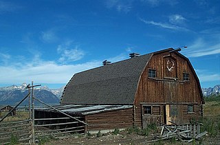
The Hunter Hereford Ranch was first homesteaded in 1909 by James Williams in the eastern portion of Jackson Hole, in what would become Grand Teton National Park. By the 1940s it was developed as a hobby ranch by William and Eileen Hunter and their foreman John Anderson. With its rustic log buildings it was used as the shooting location for the movie The Wild Country, while one structure with a stone fireplace was used in the 1963 movie Spencer's Mountain. The ranch is located on the extreme eastern edge of Jackson Hole under Shadow Mountain. It is unusual in having some areas of sagebrush-free pasture.

The Rand Ranger Station is a Bureau of Land Management compound consisting of eight historic buildings located in the Rogue River-Siskiyou National Forest in southwest Oregon. It was built by the United States Forest Service and the Civilian Conservation Corps as a district ranger station for the Galice Ranger District. The ranger station property was transferred to the Bureau of Land Management in 1970. Today, the ranger station office serves as a visitor center. The Rand Ranger Station is listed on the National Register of Historic Places.

The Rogue River Ranch is a pioneer farm complex in Curry County in southwest Oregon, United States. The ranch is located on the north shore of the Rogue River just outside the Rogue River-Siskiyou National Forest. The original ranch buildings were constructed by George Billings. Later, the ranch was sold to Stanley Anderson, who increased the size of the property and built additional farm buildings. The Bureau of Land Management bought the ranch in 1970. Today, the main ranch house is a museum. The Bureau of Land Management also maintains a campground on the property. The Rogue River Ranch is listed on the National Register of Historic Places.
The Earnest Farms Historic District is a historic district consisting of four historic farms and associated structures near the community of Chuckey in Greene County, Tennessee, United States. The farms include the Elmwood Farm, the Broyles Farm, the Crum Farm, and the Jim Earnest Farm, all of which were initially developed by early pioneer Henry Earnest (1732–1809) and his descendants in the late-18th and 19th centuries. The district includes the Ebenezer Methodist Church, which is home to the oldest Methodist congregation in Tennessee, and the Earnest Fort House, which is one of the oldest houses in the state. Elmwood Farm has been designated a century farm and is one of the oldest farms in Tennessee, having been cultivated continuously since 1777.

The David L. Shirk Ranch is a historic ranch located in the Guano Valley of eastern Lake County, Oregon, United States. The ranch was originally homesteaded in 1881. It was purchased by David L. Shirk in 1883. He operated the ranch until 1914. The property was acquired by the United States Government in 1942. The ranch is now administered by the Bureau of Land Management. The remaining historic ranch buildings are listed on the National Register of Historic Places.
The Elwha Ranger Station is a historic district in Olympic National Park, originally built in the 1930s for the U.S. Forest Service. The complex of fourteen buildings is divided in two by Olympic Hotsprings Road. To the east lie the ranger station and three residences, with nine maintenance buildings on the west side of the road. The complex was turned over to the National Park Service in 1940 when the land was added to Olympic National Park from Olympic National Forest. Construction is typical of USFS practice, and reflects the Forest Service's preference of the time for bungalow and American Craftsman style architecture.

The Owen-Primm House was originally a log cabin built by Jabez Owen c. 1806, and later expanded with wood framing by Thomas Perkins Primm c. 1845. This property in Brentwood, Tennessee was listed on the National Register of Historic Places in 1988.
"Maplewood", also known as Sebrell-McCausland Farm, is a historic home and national historic district located near Pliny, Mason County, West Virginia. The district includes eight contributing buildings and four contributing sites. The main house is a two-story Italianate-style brick farmhouse with wood siding. It features two round attic portholes and three porches. Also on the property are the following contributing buildings / sites: a coal house, chicken house, blacksmith shop, and well house all built about 1870; the Jenny Lind House ; a schoolhouse / storage shed ; machine shed ; the ruins of the main barn and hog barn ; and the Sebrell-McCausland Cemetery and Slave Cemetery, both established about 1850.

Reliance is an unincorporated community in Polk County, Tennessee, United States. Reliance is located on the Hiwassee River at the junction of Tennessee State Route 30 and Tennessee State Route 315, 8.8 miles (14.2 km) east of Benton. Reliance had a post office until it closed on May 21, 2011; it still has its own ZIP code, 37369.

Ananias Pitsenbarger Farm is an historic home and farm complex located in the unincorporated community of Dahmer, near Franklin, Pendleton County, West Virginia. The original section of the house was built in 1845, and includes the 2+1⁄2-story section on the north end, with a later 1+1⁄2-story addition built about 1900. The house rests on a foundation of coursed rubble stone and is clad in weatherboard siding. It has a standing-seam metal gable roof. Also on the property are 15 log and frame contributing outbuildings. They include the cellar house, two hog pens, a stable, woodworking shop, carriage house, chicken coop, granary, shed, privy constructed by the Works Progress Administration, spring house, three small hay barns, and a large double-crib log hay barn. Also on the property is the Pitsenbarger Cemetery.

The Brugjeld–Peterson Family Farmstead District, also known as Lakeside Farm and the Peterson Point Historical Farmstead, is a historic district in rural Emmet County, Iowa, United States, near the town of Wallingford. It was listed on the National Register of Historic Places in 2000.
The Flying Horseshoe Ranch was established in the Centennial Valley of southeastern Wyoming by Danish immigrant Mads Wolbol in the late 1870s. The complex of mostly log structures, about 15 of which are considered contributing structures.

The Colter Ranch Historic District consists of twelve buildings in a rural setting near Eagar, Arizona. The site is located in the Amity Valley, which itself is part of Round Valley ; the Little Colorado River runs along the one side of the district. Most of the buildings date from between 1904 and 1930, the period during which Fred Colter resided on the residence.
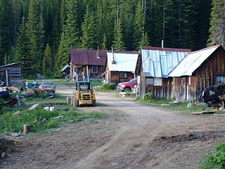
The Gildersleeve Mine, in Lolo National Forest near Superior in Mineral County, Montana, was a gold and barite mine listed on the National Register of Historic Places in 2002.
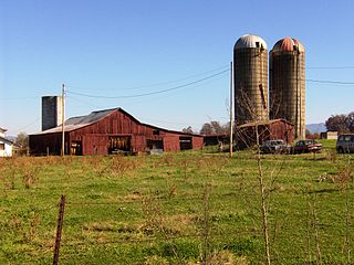
The Gramberg Ranch, in Pennington County, South Dakota near Hermosa, was listed on the National Register of Historic Places in 1999. The listing included eight contributing buildings, six contributing structures, and four contributing sites.


