Gafsa

Last updated

Gafsa
قفصة
Gafsa.jpg
Tunisia adm location map.svg
Red pog.svg
Gafsa
Location in Tunisia
Coordinates: 34°25′21″N8°47′03″E / 34.42250°N 8.78417°E / 34.42250; 8.78417
CountryFlag of Tunisia.svg  Tunisia
Governorate Gafsa Governorate
Delegation(s) Gafsa North, Gafsa South
Government
   Mayor Helmi Belhani ( Nidaa Tounes )
Population
 (2014)
  Total111,170
Time zone UTC1 (CET)

Gafsa (Arabic : قفصة qafṣah/gafṣah Gafsˤa ) is the capital of Gafsa Governorate of Tunisia. With a population of 111,170, Gafsa is the ninth-largest Tunisian city and it is 335 kilometers from the capital Tunis.

Contents

Overview

View of Gafsa Vue de la ville de Gafsa, Tunisie juin 2013.jpg
View of Gafsa

Gafsa is the capital of the southwest of Tunisia and is both a historical oasis and home to the mining industry of Tunisia. The city had 111,170 inhabitants at the 2014 census, under the rule of the mayor, Helmi Belhani. [1] The city lies 369 km (229 mi) by road southwest of Tunis. Its geographical coordinates are 34°25′N8°47′E / 34.417°N 8.783°E / 34.417; 8.783 .

History

Ancient history

Capsa in Roman times was near the "limes romanus" called Fossatum Africae. Fossatum.png
Capsa in Roman times was near the "limes romanus" called Fossatum Africae.
Roman baths of Gafsa. Roman Pool in Gafsa.jpg
Roman baths of Gafsa.

Excavations at prehistoric sites in the Gafsa area have yielded artefacts and skeletal remains associated with the Capsian culture. This Mesolithic civilisation has been radiocarbon dated to between 10,000 and 6,000 BCE. The associated ancient population, known as the Snail eaters, are known for their extensive middens of snail shells. They are believed to be the ancestors of the modern Berbers. [2]

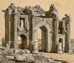
The city was originally called Capsa in Latin. Gafsa lends its Latin name of Capsa to the Mesolithic Capsian culture. It belonged to King Jugurtha, who deposited his treasures there. It was captured by Gaius Marius in 106 BC and destroyed, later becoming reestablished under the Punic-style magistracy of sufetes before being granted the status of a Roman colonia. [3] [4] Capsa was an important city of Roman Africa near the Fossatum Africae. [5] Roman cisterns are still evident in the city ruins. [5]

The Vandals conquered the Roman city and ruled it until the death of Genseric (477). The Berbers then occupied it, making it the capital of a Romano-Berber kingdom until subjected to Byzantium under Justinian I (527–565) and the era of Byzantine North Africa. He made Capsa the capital of the province of Byzacena. The Duke of Byzacena resided there. In 540, the Byzantine governor general Solomon built a new city wall, naming the city Justiniana Capsa. [3]

The Arab army of Uqba ibn Nafi conquered Gafsa in 688, in spite of resistance from the Berbers. [6] After the Arab conquest, Capsa started to lose importance, replaced by Muslim-founded Kairouan.

Historians such as Camps and Laverde consider Gafsa the place in North Africa where African Romance last survived, until the 13th century, as a spoken language.

Al Yacoubi reports that this time its inhabitants were considered Romanized Berber and Al-Idrissi says they continued to speak an African Latin and part of them remained faithful to the Christian religion.Gafsa ASM

Recent history

Phosphate mines were discovered in 1886, and Gafsa today is home to one of the largest mines of phosphate in the world.

The travel-book ‘Fountains in the Sand’ (1912) by British author Norman Douglas gives an in-depth account of life and work in Gafsa.

In the Second World War, Gafsa suffered heavy bombardment from both the German and Italian side and the Allies. Part of its Kasbah was destroyed.

On 27 January 1980, a group of dissidents armed and trained by Libya occupied the city to contest the régime of Habib Bourguiba. 48 people were killed in the battles.

The Gafsa region has had an active political voice throughout its history, and various events there have shaped its political developments in the various phases of modern Tunisia.

In 2008, Gafsa was the center of riots directed against the government of President Zine El Abidine Ben Ali. The government was swift and brutal in its suppression of the uprising, but this movement has since been credited with sowing the first seeds of the Jasmine Revolution that removed Zine El Abidine Ben Ali from power three years later, igniting the Arab Spring across much of North Africa and the Middle East.

In 2014, a lake suddenly appeared around 25 kilometers from the town. The cause of the lake's formation is currently unknown. [7]

Bishopric

Map showing Capsa Tunisia Antica.jpg
Map showing Capsa

Extant documents give the names of a few of the bishops of Capsa. [8] [9] [10]

In the 3rd century, Donatulus took part in the council that Saint Cyprian convoked in Carthage in 256 to discuss the problem of the lapsi .

In the 4th century, at the Council of Carthage (349), Fortunatianus of Capsa was present, mentioned as the first among the bishops of Byzacena. A Donatist bishop of Capsa called Quintasius was at the council held at Cabarsussi in 393 by a breakaway group of Donatists led by Maximianus.

In the 5th century, at the joint Council of Carthage (411) attended by Catholics and Donatists, Gams and Morcelli say Capsa was represented by the Donatist Donatianus, and that it had no Catholic bishop. [9] [10] According to the more recent Mesnage, Donatianus was instead the Donatist bishop of Capsus in Numidia, and Capsa in Byzacena was represented by the Catholic Fortunatus and the Donatist Celer, whom the earlier sources attributed to Capsus. [8] All three sources agree in attributing to Capsa the Vindemialis who was one of the Catholic bishops whom Huneric summoned to Carthage in 484 and then exiled. However, the latest editions of the Roman Martyrology, which commemorates Vindemialis on 2 May, call him bishop of Capsus in Numidia. [11]

Capsa still had resident bishops at the end of the 9th century, being mentioned in a Notitia Episcopatuum of Leo VI the Wise (886–912). [8] but a community may have lasted until the early 12th century [12]

No longer a residential bishopric, Capsa is today listed by the Catholic Church as a titular see. [13]

Climate

Gafsa has a hot desert climate (Köppen climate classification BWh).

Climate data for Gafsa (1991–2020, extremes 1950–2022)
MonthJanFebMarAprMayJunJulAugSepOctNovDecYear
Record high °C (°F)24.8
(76.6)
32.0
(89.6)
36.9
(98.4)
38.0
(100.4)
42.8
(109.0)
46.1
(115.0)
46.5
(115.7)
45.7
(114.3)
43.5
(110.3)
39.5
(103.1)
35.5
(95.9)
29.0
(84.2)
46.5
(115.7)
Mean daily maximum °C (°F)15.8
(60.4)
17.5
(63.5)
21.3
(70.3)
25.4
(77.7)
30.3
(86.5)
35.3
(95.5)
38.4
(101.1)
37.9
(100.2)
32.9
(91.2)
27.8
(82.0)
21.2
(70.2)
16.6
(61.9)
26.7
(80.1)
Daily mean °C (°F)10.0
(50.0)
11.4
(52.5)
14.9
(58.8)
18.6
(65.5)
23.2
(73.8)
27.8
(82.0)
30.7
(87.3)
30.6
(87.1)
26.7
(80.1)
21.7
(71.1)
15.4
(59.7)
11.0
(51.8)
20.2
(68.4)
Mean daily minimum °C (°F)4.1
(39.4)
5.3
(41.5)
8.4
(47.1)
11.8
(53.2)
16.1
(61.0)
20.2
(68.4)
23.0
(73.4)
23.3
(73.9)
20.4
(68.7)
15.6
(60.1)
9.5
(49.1)
5.5
(41.9)
13.6
(56.5)
Record low °C (°F)−5.5
(22.1)
−4.3
(24.3)
−2.1
(28.2)
1.8
(35.2)
6.0
(42.8)
9.1
(48.4)
13.8
(56.8)
15.1
(59.2)
10.3
(50.5)
2.6
(36.7)
−1.2
(29.8)
−4.9
(23.2)
−5.5
(22.1)
Average precipitation mm (inches)15.1
(0.59)
10.6
(0.42)
15.7
(0.62)
16.4
(0.65)
13.4
(0.53)
3.4
(0.13)
3.4
(0.13)
5.9
(0.23)
20.2
(0.80)
18.0
(0.71)
18.2
(0.72)
13.7
(0.54)
154.1
(6.07)
Average precipitation days (≥ 1.0 mm)2.22.12.42.32.10.70.50.82.52.52.02.422.5
Average relative humidity (%)65615855524743485561656856
Mean monthly sunshine hours 204.6212.8244.9267.0306.9324.0356.5337.9282.0254.2222.0207.73,220.5
Mean daily sunshine hours 6.67.67.98.99.910.811.510.99.48.27.46.78.8
Source 1: Institut National de la Météorologie (humidity/sun 1961–1990) [14] [15] [16] [note 1]
Source 2: NOAA(humidity and sun 1961–1990) [18] [19] [20]

Economy

Companie des phosphates de Gafsa Compagnie des phosphates de Gafsa.jpg
Companie des phosphates de Gafsa

Gafsa is developing thanks to the mining of phosphates, the deposit of which discovered in 1886 is one of the largest in the world. Tunisia extracted nearly five million tonnes of phosphates in 2011. Production fell after the revolution to reach 3,500,000 tonnes in 2016. Tunisia has thus fallen from seventh in the world to tenth. The Compagnie des phosphates de Gafsa had its own private railway line until 1966, on the basis of an agreement signed on 25 August 1896. Paradoxically, the city is quite poor and does not benefit from income from phosphate. [21]

Transport

Gafsa – Ksar International Airport is located in the city.

Sport

El Gawafel Sportives de Gafsa.png

El Kawafel Sportives de Gafsa (Arabic: القوافل الرياضية بقفصة, often referred to as EGSG) is the main football club of Gafsa.

Media

Radio stations:

and other government and private Tunisian radios broadcast in Gafsa as Shems FM, RTCI, Youth Radio, Culture Radio, Zitouna, and the National Radio.

International relations

Twin towns – Sister cities

Gafsa is twinned with:

See also

Related Research Articles

<span class="mw-page-title-main">Tozeur</span> City in Tozeur Governorate, Tunisia

Tozeur is a city in southwest Tunisia. The city is located northwest of Chott el Djerid, in between this Chott and the smaller Chott el Gharsa. It is the capital of Tozeur Governorate. It was the site of the ancient city and former bishopric Tusuros, which remains a Latin Catholic titular see.

<span class="mw-page-title-main">Gabès</span> City in Gabès Governorate, Tunisia

Gabès, also spelled Cabès, Cabes, Kabes, Gabbs and Gaps, is the capital city of the Gabès Governorate in Tunisia. It is located on the coast of the Gulf of Gabès. With a population of 152,921, Gabès is the 6th largest Tunisian city. Gabes is 327 km away from Tunis and 113 km away from Sfax.

<span class="mw-page-title-main">Zaghouan</span> Place in Zaghouan Governorate, Tunisia

Zaghouan is a town in the northern half of Tunisia.

Kelibia (Kélibia), often referred to as Klibia or Gallipia by European writers, is a coastal town on the Cap Bon peninsula, Nabeul Governorate in the far north-eastern part of Tunisia. Its sand beaches are considered some of the finest in the Mediterranean.

<span class="mw-page-title-main">Thelepte</span> Place in Kasserine Governorate, Tunisia

Thelepte was a city in the Roman province of Byzacena, now in western Tunisia. It is located near the border with Algeria about 5 km north from the modern town of Fériana and 30 km south-west of the provincial capital Kasserine.

<span class="mw-page-title-main">Haïdra</span> Place in Kasserine Governorate, Tunisia

Haïdra is a municipality in western Tunisia, containing the ruins of Ammaedara, one of the oldest Roman cities in Africa. It was a diocese and is now a Roman Catholic titular see.

<span class="mw-page-title-main">Thala, Tunisia</span> Town in Kasserine Governorate, Tunisia

Thala is a town and commune in Tunisia. It is located in the Kasserine Governorate since 1956. As of the 2004 census it had 13,968 inhabitants. The altitude of Thala is 1,017 metres (3,337 ft), which makes it the highest and the coldest town in the country.

<span class="mw-page-title-main">Kasserine</span> Place in Kasserine Governorate, Tunisia

Kasserine is the capital city of the Kasserine Governorate, in west-central Tunisia. It is situated below Jebel ech Chambi, Tunisia's highest mountain. Its population is 114,463 (2020).

<span class="mw-page-title-main">Bir El Hafey</span> Commune and town in Sidi Bouzid Governorate, Tunisia

Bir El Hafey is a town and commune located at 34°55′48″N 9°12′00″E in the Sidi Bouzid Governorate, in Tunisia. As of 2004 it had a population of 6,405.

<span class="mw-page-title-main">Thagamuta</span>

Thagamuta was a Roman–Berber city in the province of Byzacena. The location of the town is not definitively known, but it was on the plain of Guemouda in modern Tunisia.

Buleliana was a civitas (town) and bishopric in Roman North Africa and remains a Latin Catholic titular see.

<span class="mw-page-title-main">Auzegera</span> Roman-Berber town

Auzegera was a Roman-Berber town in the province of Africa Proconsularis and in late antiquity Byzacena. It was a Catholic Church diocese.

<span class="mw-page-title-main">Medeli</span> Ancient Roman & Berber town in Tunesia

Medeli was an ancient Roman–Berber civitas of the Roman Province of Africa Proconsularis in Tunisia. It has been tentatively identified with Henchir-Mencoub and lasted through the Roman, Vandal and Byzantine empires.

Henchir-Bladia is an archaeological site and locality in southern Tunisia. The stone ruins are tentatively associated with Bladia, a civitas of the Roman province of Byzacena during the Roman Empire. It was a Catholic bishopric.

<span class="mw-page-title-main">Aquae in Byzacena</span>

The Diocese of Aquensis in Byzacena is a home suppressed and titular see of the Roman Catholic Church.

<span class="mw-page-title-main">Crepedula</span>

Crepedula was an ancient Roman–Berber civitas in the province of Byzacena in Africa Proconsularis. It was located in modern Tunisia. The town was also the seat of a Catholic diocese.

<span class="mw-page-title-main">Diocese of Dices</span> Roman Catholic titular see

The Diocese of Dices, is a titular see of the Roman Catholic Church. The location of the seat of the diocese is unknown for certain, but is perhaps identifiable with Henchir-Sidi-Salah, Tunisia. Henchir Sidi Salah was an ancient diocese in the Roman-Berber province of Byzacena.

<span class="mw-page-title-main">Muzuca in Byzacena</span>

Muzuca was a Roman Town of the Roman province of Byzacena during late antiquity. The town has tentatively been identified with the ruins at Henchir-Besra in modern Tunisia. Very little is known of the city, though in situ epigraphical evidence gives us the name and that in late antiquity it achieved the status of Municipium.

<span class="mw-page-title-main">Marazanae</span>

Marazanae was a Roman town of the Roman province of Byzacena during the Roman Empire and into late antiquity.

<span class="mw-page-title-main">Capsa (Roman colonia)</span> Gafsa, Tunisia historic era

Capsa was a Roman colonia located in the south of modern-day Tunisia. Before Roman times Capsa was a center of the Capsian culture.

References

  1. "Recensement de 2004 (Institut National de la Statistique – Tunisie)". ins.nat.tn. Archived from the original on 24 September 2015. Retrieved 27 March 2016.
  2. Paul Lachlan MacKendrick, The North African Stones Speak (UNC Press Books, 1 December 2000).
  3. 1 2 Siméon Vailhé, "Capsa" in Catholic Encyclopedia (New York 1908)
  4. Ilẹvbare, J.A. (June 1974). "The Impact of the Carthaginians and the Romans on the Administrative System of the Maghreb Part I". Journal of the Historical Society of Nigeria. 7 (2): 187–197. JSTOR   41857007.
  5. 1 2 Trudy Ring, Robert M. Salkin, Sharon La Boda International Dictionary of Historic Places: Middle East and Africa, Volume 4 (Taylor & Francis, 1994) p312.
  6. History of Gafsa (in French) Archived 15 May 2014 at the Wayback Machine
  7. "Gafsa Beach: Mysterious Lake Discovered in Drought-Stricken Tunisia Could be 'Radioactive'". uk.news.yahoo.com. Retrieved 27 March 2016.
  8. 1 2 3 J. Mesnage, L'Afrique chrétienne, Paris 1912, pp. 69–70
  9. 1 2 Pius Bonifacius Gams, Series episcoporum Ecclesiae Catholicae, Leipzig 1931, p. 464
  10. 1 2 Stefano Antonio Morcelli, Africa christiana, Volume I, Brescia 1816, pp. 118–119
  11. Martyrologium Romanum (Libreria Editrice Vaticana 2001 ISBN   978-1274930071)
  12. "The Last Christians Of North-West Africa: Some Lessons For Orthodox Today". orthodoxengland.org.uk. Retrieved 27 March 2016.
  13. Annuario Pontificio 2013 (Libreria Editrice Vaticana 2013 ISBN   978-88-209-9070-1), p. 838
  14. "Les normales climatiques en Tunisie entre 1981 2010" (in French). Ministère du Transport. Archived from the original on 19 December 2019. Retrieved 3 February 2020.
  15. "Données normales climatiques 1961–1990" (in French). Ministère du Transport. Archived from the original on 21 December 2019. Retrieved 3 February 2020.
  16. "Les extrêmes climatiques en Tunisie" (in French). Ministère du Transport. Archived from the original on 21 December 2019. Retrieved 3 February 2020.
  17. "Réseau des stations météorologiques synoptiques de la Tunisie" (in French). Ministère du Transport. Retrieved 3 February 2020.
  18. "Gafsa Climate Normals 1961–1990". National Oceanic and Atmospheric Administration . Retrieved 24 January 2015.
  19. "Climate Normals 1991-2020". NOAA.gov. National Oceanic and Atmospheric Administration . Retrieved 18 September 2018.
  20. "60745: Gafsa (Tunisia)". ogimet.com. OGIMET. 1 July 2022. Retrieved 3 July 2022.
  21. : Phosphate Rock
  22. Vacca, Maria Luisa. "Comune di Napoli -Gemellaggi" [Naples – Twin Towns]. Comune di Napoli (in Italian). Archived from the original on 22 July 2013. Retrieved 8 August 2013.

Notes

  1. The Station ID for Gafsa is 64545111. [17]