Garden City, Idaho

Last updated

Garden City, Idaho
0725wwp01aerial.jpg
Garden City as seen with downtown Boise in the background.
Ada County Idaho Incorporated and Unincorporated areas Garden City Highlighted 1629620.svg
Location of Garden City in Ada County, Idaho.
Usa edcp location map.svg
Red pog.svg
Garden City, Idaho
Location in the United States
Coordinates: 43°38′44″N116°15′58″W / 43.64556°N 116.26611°W / 43.64556; -116.26611
CountryUnited States
State Idaho
County Ada
Government
  MayorJohn Evans
  Council PresidentJames Page
  Council Members
List
  • Russ Heller
    Bill Jacobs
    Teresa Jorgensen
Area
[1]
  Total4.28 sq mi (11.07 km2)
  Land4.08 sq mi (10.57 km2)
  Water0.20 sq mi (0.50 km2)
Elevation
2,674 ft (815 m)
Population
 (2020) [2]
  Total12,316
  Density3,018/sq mi (1,165/km2)
Time zone UTC−7 (Mountain (MST))
  Summer (DST) UTC−6 (MDT)
ZIP codes
83703, 83714
Area code(s) 208, 986
FIPS code 16-29620
GNIS feature ID0396529
Website gardencityidaho.org

Garden City is a city in Ada County, Idaho. The population was 12,316 at the time of the 2020 census. Garden City is nearly surrounded by Boise but retains a separate municipal government.

Contents

Garden City was named for gardens raised by Chinese immigrants who lived in the area. The name of the city's only main street, Chinden Boulevard, is a portmanteau of the words "China" and "garden." In the second decade of the 21st century, it became a haven for artists' studios. [3]

Garden City is part of the Boise metropolitan area.

Geography

Garden City is located at 43°38′44″N116°15′58″W / 43.64556°N 116.26611°W / 43.64556; -116.26611 (43.645561, -116.266132), [4] at an elevation of 2674 feet (815 m) above sea level.

According to the United States Census Bureau, the city has a total area of 4.17 square miles (10.80 km2), of which 4.04 square miles (10.46 km2) is land and 0.13 square miles (0.34 km2) is water. [5]

Demographics

Historical population
CensusPop.Note
1950 764
1960 1,681120.0%
1970 2,36840.9%
1980 4,57193.0%
1990 6,36939.3%
2000 10,62466.8%
2010 10,9723.3%
2020 12,31612.2%
U.S. Decennial Census [6]

2010 census

At the 2010 census there were 10,972 people, 4,878 households, and 2,849 families living in the city. The population density was 2,715.8 inhabitants per square mile (1,048.6/km2). There were 5,429 housing units at an average density of 1,343.8 per square mile (518.8/km2). The racial makeup of the city was 86.2% White, 1.0% African American, 1.1% Native American, 1.4% Asian, 0.1% Pacific Islander, 7.1% from other races, and 3.1% from two or more races. Hispanic or Latino of any race were 13.8%. [2]

Of the 4,878 households 24.6% had children under the age of 18 living with them, 42.3% were married couples living together, 11.2% had a female householder with no husband present, 4.9% had a male householder with no wife present, and 41.6% were non-families. 34.0% of households were one person and 14.5% were one person aged 65 or older. The average household size was 2.22 and the average family size was 2.81.

The median age was 43.2 years. 20.6% of residents were under the age of 18; 8.9% were between the ages of 18 and 24; 22.3% were from 25 to 44; 29.2% were from 45 to 64; and 18.8% were 65 or older. The gender makeup of the city was 48.4% male and 51.6% female.

2000 census

At the 2000 census there were 10,624 people, 4,331 households, and 2,784 families living in the city. The population density was 2,559.9 per square mile. There were 4,590 housing units at an average density of 1,106.0 per square mile. The racial makeup of the city was 89.3% White, 0.5% African American, 0.9% Native American, 1.4% Asian, 0.1% Pacific Islander, 4.9% from other races, and 2.9% from two or more races. Hispanic or Latino of any race were 9.6%. [7]

Of the 4,331 households 29.8% had children under the age of 18 living with them, 47.7% were married couples living together, 10.9% had a female householder with no husband present, and 35.7% were non-families. 27% of households were one person and 8.3% were one person aged 65 or older. The average household size was 2.43 and the average family size was 2.91.

The age distribution was 24.3% under the age of 18, 10.8% from 18 to 24, 29.9% from 25 to 44, 22.6% from 45 to 64, and 12.5% 65 or older. The median age was 35 years. For every 100 females, there were 103.1 males. For every 100 females age 18 and over, there were 101.3 males.

The median household income was $38,520 and the median family income was $46,463. Males had a median income of $30,499 versus $28,315 for females. The per capita income for the city was $24,242. About 9.8% of families and 12.7% of the population were below the poverty line, including 16.6% of those under age 18 and 4.0% of those age 65 or over.

Joan Jett Concert at Western Idaho Fairgrounds Joan Jett Concert at Western Idaho Fairgrounds, August 2017.jpg
Joan Jett Concert at Western Idaho Fairgrounds

Education

Most of Garden City is in Boise School District. A portion is in the West Ada School District (Meridian Joint School District 2). [8]

The Boise School District portion is zoned as follows:

See also

Related Research Articles

<span class="mw-page-title-main">Elmore County, Idaho</span> County in Idaho, United States

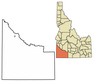
Elmore County is a county in the U.S. state of Idaho. As of the 2020 census, the population was 28,666. The largest city and county seat is Mountain Home.

<span class="mw-page-title-main">Canyon County, Idaho</span> County in Idaho, United States

Canyon County is located in the U.S. state of Idaho. As of the 2020 Census, the population was 231,105, which by 2022 was estimated to have risen to 251,065. making it the second-most populous county in Idaho. The county seat is Caldwell, and its largest city is Nampa. Canyon County is part of the Boise metropolitan area.

<span class="mw-page-title-main">Boise County, Idaho</span> County in Idaho, United States

Boise County is a rural mountain county in the U.S. state of Idaho. As of the 2020 United States Census, the population was 7,610. The county seat is historic Idaho City, which is connected through a series of paved and unpaved roads to Lowman, Centerville, Placerville, Pioneerville, Star Ranch, Crouch, Garden Valley, and Horseshoe Bend.

<span class="mw-page-title-main">Ada County, Idaho</span> County in Idaho, United States

Ada County is located in the southwestern part of Idaho, United States. As of the 2020 census, the county had a population of 494,967, which by 2022 was estimated to have risen to 518,907. Ada County is by far the state's most populous county; it is home to 26.8% of the state's population. The county seat and largest city is Boise, which is also the state capital. Ada County is included in the Boise metropolitan area. The Ada County Highway District has jurisdiction over all the local county and city streets, except for private roads and state roads. In the interior Pacific Northwest east of the Cascade Range, Ada County ranks second in population, behind Spokane County, Washington.

<span class="mw-page-title-main">Eagle, Idaho</span> City in Idaho, United States

Eagle is a city in Ada County, Idaho 10 miles (16 km) northwest of Boise. The population was 30,346 at the 2020 census.

<span class="mw-page-title-main">Star, Idaho</span> City in Idaho, United States

Star is a city in northwestern Ada County, Idaho, with parts stretching into neighboring Canyon County. The population was 11,117 at the 2020 census, up from 5,793 in 2010. It was named in the 19th century by travelers on their way to Middleton and Boise who used the star on the school house to find east and west. The name stuck and it became Star, Idaho. Today, it is a rapidly growing suburb of Boise and its schools are shared with Middleton School District and West Ada School District.

<span class="mw-page-title-main">Horseshoe Bend, Idaho</span> City in Idaho, United States

Horseshoe Bend is the largest city in rural Boise County, in the southwestern part of the U.S. state of Idaho. Its population of 707 at the 2010 census was the largest in the county, though down from 770 in 2000.

<span class="mw-page-title-main">Idaho City, Idaho</span> Town in Idaho, United States

Idaho City is a town in, and the county seat of, Boise County, Idaho, United States, located about 36 miles (58 km) northeast of Boise. The population was 485 at the 2010 census, up from 458 in 2000.

<span class="mw-page-title-main">Middleton, Idaho</span> City in Idaho, United States

Middleton is a city in Canyon County, Idaho, United States. The population amounted to 9,091 at the 2021 census estimate, up from 5,524 at the 2010 census and 2,978 in 2000. It is part of the Boise City–Nampa, Idaho Metropolitan Statistical Area.

<span class="mw-page-title-main">Notus, Idaho</span> City in Idaho, United States

Notus is a small rural city in Canyon County, Idaho. The population was 531 at the time of the 2010 census and is the smallest town out of the eight in Canyon County. It is part of the Boise metropolitan area.

<span class="mw-page-title-main">Parma, Idaho</span> City in Canyon County, Idaho, United States

Parma is a city in Canyon County, Idaho, United States. The population was 1,983 at the 2010 census, up from 1,771 in 2000. It is the fourth largest city in the county and the largest in the rural western portion. It is part of the Boise City–Nampa, Idaho Metropolitan Statistical Area.

<span class="mw-page-title-main">Emmett, Idaho</span> City in Idaho, United States

Emmett is a city in Gem County, Idaho, United States. The population was 6,557 at the 2010 census, up from 5,490 in 2000. It is the county seat and the only city in the county. Emmett is part of the Boise−Nampa, Idaho Metropolitan Statistical Area.

<span class="mw-page-title-main">Homedale, Idaho</span> City in Idaho, United States

Homedale is a city in Owyhee County Idaho. The population was 2,633 at the time of the 2010 census. The town name was chosen by drawing names from a hat during a community picnic. Homedale is part of the Boise metropolitan area. It was, at one time, the terminus of a branch of the Oregon Short Line Railroad.

<span class="mw-page-title-main">Donnelly, Idaho</span> City in Idaho, United States

Donnelly is a city in rural Valley County, Idaho, United States. The population was 152 at the 2010 census.

<span class="mw-page-title-main">Rembrandt, Iowa</span> City in Iowa, United States

Rembrandt is a city in Buena Vista County, Iowa, United States. The population was 209 at the time of the 2020 census.

<span class="mw-page-title-main">Bel Aire, Kansas</span> City in Sedgwick County, Kansas

Bel Aire is a city in Sedgwick County, Kansas, United States, and a suburb of Wichita. As of the 2020 census, the population of the city was 8,262.

<span class="mw-page-title-main">Brooklin, Maine</span> Town in the state of Maine, United States

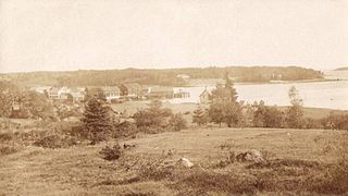
Brooklin is a town in Hancock County, Maine, United States. The population was 827 at the 2020 census.

<span class="mw-page-title-main">Dimondale, Michigan</span> Village in Michigan, United States

Dimondale is a village in Eaton County in the U.S. state of Michigan. The population was 1,234 at the 2010 census. The village is located within Windsor Charter Township. Dimondale is a suburb of Lansing, which is northeast of the village in Ingham County.

<span class="mw-page-title-main">Ogallala, Nebraska</span> City in Nebraska, United States

Ogallala is a city in and the county seat of Keith County, Nebraska, United States. The population was 4,878 at the 2020 census, up from 4,737 at the 2010 census. In the days of the Nebraska Territory, the city was a stop on the Pony Express and later along the transcontinental railroad. The Ogallala Formation that carries the Ogallala Aquifer was named after the city.

<span class="mw-page-title-main">Edwardsville, Pennsylvania</span> Borough in Pennsylvania, United States

Edwardsville is a borough in Luzerne County, Pennsylvania, United States. The population was 4,918 at the 2020 census.

References

  1. "2019 U.S. Gazetteer Files". United States Census Bureau. Retrieved July 9, 2020.
  2. 1 2 "U.S. Census website". United States Census Bureau . Retrieved December 18, 2012.
  3. Barnhill, Frankie (May 14, 2015). "Growing Garden City: Why More Boise Artists Are Making The Move To Garden City". www.boisestatepublicradio.org. Retrieved September 25, 2020.
  4. "US Gazetteer files: 2010, 2000, and 1990". United States Census Bureau. February 12, 2011. Retrieved April 23, 2011.
  5. "US Gazetteer files 2010". United States Census Bureau. Archived from the original on July 2, 2012. Retrieved December 18, 2012.
  6. "Census of Population and Housing". Census.gov. Retrieved June 4, 2015.
  7. "U.S. Census website". United States Census Bureau . Retrieved January 31, 2008.
  8. "2020 CENSUS - SCHOOL DISTRICT REFERENCE MAP: Ada County, ID" (PDF). U.S. Census Bureau . Retrieved July 21, 2022. - Text list
  9. "Elementary School Boundaries". Boise School District . Retrieved July 21, 2022. - Linked from here
  10. "Jr High School Boundaries" (PDF). Boise School District . Retrieved July 21, 2022.
  11. "Sr High School Boundaries" (PDF). Boise School District . Retrieved July 21, 2022.