Geography of Halifax, Nova Scotia

Last updated

The Halifax Regional Municipality (HRM) in Nova Scotia, Canada has a widely varied geography.

Contents

Physical geography

Halifax Regional Municipality has an area of approximately 5,490.35 km2 (2,119.84 sq mi), [1] and is approximately 165 km (103 mi) in length between its eastern and westernmost extremities. HRM's shoreline "as the crow flies" is approximately 150 km (93 mi) in length, while its northern boundary is usually between 50 and 60 km inland. The coast, which is mostly rock with small isolated sand beaches in sheltered bays, is heavily indented by numerous inlets the largest of which are St. Margarets Bay, Halifax Harbour, Cole Harbour, Musquodoboit Harbour, Jeddore Harbour, Ship Harbour and Sheet Harbour. Given this fact, it takes approximately 3 hours to drive along the shore from Hubbards, located in the southwestern end of HRM, to Ecum Secum, 195 km (121 mi) away at the northeastern end.

Halifax Harbour from the air looking South including the Halifax Peninsula, Dartmouth, and Bedford Halifax from the air.jpg
Halifax Harbour from the air looking South including the Halifax Peninsula, Dartmouth, and Bedford

The Chebucto Peninsula, created by the indentations of St. Margarets Bay and Halifax Harbour (including the Bedford Basin), is a defining feature for the shape of the coastline at the western end of HRM, from which the Halifax Peninsula forms a sub-peninsula.

Despite the size of its landmass, the population of the municipality is heavily concentrated, with rural communities located along the Eastern Shore and South Shore or in the Musquodoboit Valley. The majority of residents are concentrated in the urban area surrounding Halifax Harbour/Bedford Basin and extending up the Sackville River valley and northeast of the harbour along the Highway 102 corridor.

Sable Island is part of HRM, despite being located 180 km (110 mi) offshore of neighbouring Guysborough County and approximately 300 km from HRM's urban core. HRM's boundary includes all of the former Halifax County, except for several First Nation reserves.

Musquodoboit Valley Greenwood NS.JPG
Musquodoboit Valley

The topography of HRM is quite varied, ranging from rocky shorelines to sandy beaches on the coast, to landscapes shaped by glaciation including exposed bedrock, numerous freshwater lakes, medium-sized rivers and streams, drumlins and low hills. The fertile valley along the Musquodoboit River in the northeastern part of HRM is the only agricultural district of note in the municipality. Aside from the settled communities and the urban area surrounding Halifax Harbour, the rest of the municipality's landscape mostly supports a dense combination of mixed Acadian or coniferous forests.

HRM's population centre (urban area) is built on a series of hills and plateaus surrounding Halifax Harbour. The central part of the community of Halifax lies on a peninsula extending from the western side of the harbour and dominated by the drumlin which supported the Citadel Hill defensive works. Dartmouth is clustered on the eastern side of the harbour directly opposite the Halifax peninsula, its defining geographic feature being a series of glacial lakes. Suburban growth around both cities included many existing mining (east of Dartmouth and the Shubenacadie Valley), farming (in the Musquodoboit Valley and northwest of Halifax) and fishing (along the shores of the harbours and the Atlantic coast south of both former cities) communities. The population centre itself covers an area of 234.72 km2 (90.63 sq mi). [2]

Climate

Halifax
Climate chart (explanation)
J
F
M
A
M
J
J
A
S
O
N
D
 
 
151
 
 
0
−9
 
 
114
 
 
0
−8
 
 
134
 
 
4
−4
 
 
121
 
 
8
1
 
 
119
 
 
14
6
 
 
108
 
 
19
11
 
 
106
 
 
23
14
 
 
98
 
 
23
15
 
 
107
 
 
19
11
 
 
135
 
 
13
6
 
 
154
 
 
8
1
 
 
160
 
 
3
−5
Average max. and min. temperatures in °C
Precipitation totals in mm
Source: Environment Canada [3]

Halifax is marked by a humid continental climate (Köppen Dfb), but the area climate is heavily influenced by water temperatures in the adjacent Atlantic Ocean. Numerous local microclimates make weather somewhat unpredictable but the region is generally milder than inland areas having a continental climate (e.g. central Canada); HRM air temperatures average between -5 °C (23 °F) in January and 19 °C (66 °F) in July.

Snow falls and melts alternately mainly from November through April, for a seasonal total of 152 centimetres (60 in). [3] Some, but usually very little, snow falls in May and October. [3] Halifax usually experiences several strong winter storms. In February 2004 a record of 95 centimetres (37 in) of snow fell in one such storm. The storm was nicknamed "White Juan", after the recent Hurricane Juan. Spring is cool and foggy, early autumn is often sunny and warm, and summer can range from hot and dry to cool and rainy. Hurricanes are fairly uncommon but do occur occasionally. There can be considerable variations between the weather near the Atlantic Ocean and the weather even several kilometres inland. This is partly caused by the effect of the Labrador Current, which transfers cold water from the Arctic along Nova Scotia's Atlantic coast in the spring and summer, while the Gulf Stream brings warmer water from the Gulf of Mexico along the coast during the fall and winter.

Precipitation stands at nearly 1,510 millimetres (59.4 in) annually, and is somewhat heavy year-round, though summer is drier.

The Halifax Regional Municipality is home to 6 weather stations operated by the Meteorological Service of Canada:

Climate data for Halifax (Citadel Hill)
Climate ID: 8202220; coordinates 44°39′N63°35′W / 44.650°N 63.583°W / 44.650; -63.583 (Citadel Hill) ; elevation: 70.1 m (230 ft); 1981–2010 normals, extremes 1863–present [lower-alpha 1]
MonthJanFebMarAprMayJunJulAugSepOctNovDecYear
Record high °C (°F)14.0
(57.2)
16.0
(60.8)
28.2
(82.8)
28.3
(82.9)
33.3
(91.9)
34.4
(93.9)
37.2
(99.0)
34.4
(93.9)
34.6
(94.3)
31.1
(88.0)
23.3
(73.9)
16.7
(62.1)
37.2
(99.0)
Average high °C (°F)−0.1
(31.8)
0.4
(32.7)
3.6
(38.5)
8.7
(47.7)
14.4
(57.9)
19.6
(67.3)
23.1
(73.6)
23.1
(73.6)
19.3
(66.7)
13.4
(56.1)
8.1
(46.6)
2.8
(37.0)
11.4
(52.5)
Daily mean °C (°F)−4.1
(24.6)
−3.6
(25.5)
−0.2
(31.6)
4.9
(40.8)
10.1
(50.2)
15.2
(59.4)
18.8
(65.8)
19.1
(66.4)
15.5
(59.9)
9.9
(49.8)
4.8
(40.6)
−0.8
(30.6)
7.5
(45.5)
Average low °C (°F)−8.2
(17.2)
−7.5
(18.5)
−3.9
(25.0)
1.0
(33.8)
5.8
(42.4)
10.7
(51.3)
14.4
(57.9)
15.1
(59.2)
11.8
(53.2)
6.4
(43.5)
1.5
(34.7)
−4.3
(24.3)
3.6
(38.5)
Record low °C (°F)−27.2
(−17.0)
−29.4
(−20.9)
−23.3
(−9.9)
−13.9
(7.0)
−5.0
(23.0)
0.0
(32.0)
4.4
(39.9)
3.9
(39.0)
−1.7
(28.9)
−7.2
(19.0)
−15.6
(3.9)
−25.6
(−14.1)
−29.4
(−20.9)
Average precipitation mm (inches)139.7
(5.50)
110.1
(4.33)
132.5
(5.22)
118.3
(4.66)
119.1
(4.69)
111.8
(4.40)
110.3
(4.34)
96.4
(3.80)
108.9
(4.29)
124.3
(4.89)
151.4
(5.96)
145.1
(5.71)
1,468.1
(57.80)
Average rainfall mm (inches)96.7
(3.81)
75.1
(2.96)
101.3
(3.99)
111.3
(4.38)
118.4
(4.66)
111.8
(4.40)
110.3
(4.34)
96.4
(3.80)
108.9
(4.29)
124.1
(4.89)
143.6
(5.65)
115.9
(4.56)
1,313.9
(51.73)
Average snowfall cm (inches)43.1
(17.0)
35.0
(13.8)
31.2
(12.3)
7.0
(2.8)
0.8
(0.3)
0.0
(0.0)
0.0
(0.0)
0.0
(0.0)
0.0
(0.0)
0.1
(0.0)
7.8
(3.1)
29.2
(11.5)
154.2
(60.7)
Average precipitation days (≥ 0.2 mm)13.811.613.115.215.813.612.111.111.714.115.314.5161.8
Average rainy days (≥ 0.2 mm)8.56.510.214.115.713.612.111.111.714.114.510.8142.7
Average snowy days (≥ 0.2 cm)6.86.14.11.60.20.00.00.00.00.11.25.225.3
Mean monthly sunshine hours 109.5127.2142.8156.6193.3220.7235.2226.6180.5157.8107.4105.21,962.5
Percent possible sunshine 38.243.338.738.842.147.549.952.147.946.237.238.243.3
Average ultraviolet index 1235688753214
Source 1: Environment and Climate Change Canada (Sunshine data recorded at CFB Shearwater) [3] [5] [6] [7] [8] [9] [10]
Source 2: Nova Scotian Institute of Science [11] [12] [13] [14] [15] [16] [17] [18] and Weather Atlas [19]
Climate data for Halifax (Halifax Stanfield International Airport)
WMO ID: 71395; coordinates 44°52′48″N63°30′00″W / 44.88000°N 63.50000°W / 44.88000; -63.50000 (Halifax Stanfield International Airport) ; elevation: 145.4 m (477 ft); 1981−2010 normals, extremes 1953−present
MonthJanFebMarAprMayJunJulAugSepOctNovDecYear
Record high humidex 18.418.327.732.136.040.242.441.942.131.925.420.442.4
Record high °C (°F)14.8
(58.6)
17.5
(63.5)
27.2
(81.0)
29.5
(85.1)
32.8
(91.0)
33.4
(92.1)
33.9
(93.0)
35.0
(95.0)
34.2
(93.6)
25.8
(78.4)
19.4
(66.9)
16.3
(61.3)
35.0
(95.0)
Average high °C (°F)−1.3
(29.7)
−0.6
(30.9)
3.1
(37.6)
9.1
(48.4)
15.3
(59.5)
20.4
(68.7)
23.8
(74.8)
23.6
(74.5)
19.4
(66.9)
13.1
(55.6)
7.3
(45.1)
1.7
(35.1)
11.3
(52.3)
Daily mean °C (°F)−5.9
(21.4)
−5.2
(22.6)
−1.3
(29.7)
4.4
(39.9)
10.0
(50.0)
15.1
(59.2)
18.8
(65.8)
18.7
(65.7)
14.6
(58.3)
8.7
(47.7)
3.5
(38.3)
−2.4
(27.7)
6.6
(43.9)
Average low °C (°F)−10.4
(13.3)
−9.7
(14.5)
−5.7
(21.7)
−0.3
(31.5)
4.6
(40.3)
9.7
(49.5)
13.7
(56.7)
13.7
(56.7)
9.7
(49.5)
4.2
(39.6)
−0.4
(31.3)
−6.4
(20.5)
1.9
(35.4)
Record low °C (°F)−28.5
(−19.3)
−27.3
(−17.1)
−22.4
(−8.3)
−12.8
(9.0)
−4.4
(24.1)
0.6
(33.1)
6.1
(43.0)
4.4
(39.9)
−0.8
(30.6)
−6.7
(19.9)
−13.1
(8.4)
−23.3
(−9.9)
−28.5
(−19.3)
Record low wind chill −40.4−41.1−33.9−24.4−10.90.00.00.0−3.0−10.1−23.9−35.6−41.1
Average precipitation mm (inches)134.3
(5.29)
105.8
(4.17)
120.1
(4.73)
114.5
(4.51)
111.9
(4.41)
96.2
(3.79)
95.5
(3.76)
93.5
(3.68)
102.0
(4.02)
124.9
(4.92)
154.2
(6.07)
143.3
(5.64)
1,396.2
(54.97)
Average rainfall mm (inches)83.5
(3.29)
65.0
(2.56)
86.9
(3.42)
98.2
(3.87)
109.8
(4.32)
96.2
(3.79)
95.5
(3.76)
93.5
(3.68)
102.0
(4.02)
124.6
(4.91)
139.1
(5.48)
101.8
(4.01)
1,196.1
(47.09)
Average snowfall cm (inches)58
(23)
45
(18)
37
(15)
16
(6.3)
2
(0.8)
0
(0)
0
(0)
0
(0)
0
(0)
0
(0)
17
(6.7)
45
(18)
221
(87)
Average precipitation days (≥ 0.2 mm)18.715.215.114.813.712.911.311.010.212.115.117.4167.4
Average rainy days (≥ 0.2 mm)8.06.18.612.113.512.911.311.010.212.112.89.8128.4
Average snowy days (≥ 0.2 cm)14.612.09.65.20.610.00.00.00.00.143.911.757.7
Average relative humidity (%)73.067.464.562.961.962.663.062.964.466.973.275.566.5
Source: Environment and Climate Change Canada [20]

Notes

    1. Based on station coordinates provided by Environment Canada and documentation from the Nova Scotian Institute of Science, weather data was collected in West End, Halifax from January 1863 to July 1933, at Citadel Hill from August 1933 to August 1939, at Downtown Halifax from September 1939 to July 1974, at Citadel Hill from August 1974 to January 2002 and at CFB Halifax (Windsor Park and Halifax Dockyard) from September 2004 to present.

    Related Research Articles

    Nova Scotia Province of Canada

    Nova Scotia is one of the thirteen provinces and territories of Canada. It is one of the three Maritime provinces and one of the four Atlantic provinces. Nova Scotia is Latin for "New Scotland".

    Liverpool, Nova Scotia Place in Nova Scotia, Canada

    Liverpool is a Canadian community and former town located along the Atlantic Ocean of the Province of Nova Scotia's South Shore. It is situated within the Region of Queens Municipality which is the local governmental unit that comprises all of Queens County, Nova Scotia.

    Hurricane Juan Category 2 Atlantic hurricane in 2003

    Hurricane Juan was a significant tropical cyclone that heavily damaged parts of Atlantic Canada in late September 2003. Juan is also the first hurricane name and one of two to be requested to be retired by the Meteorological Service of Canada. It was the tenth named storm and the sixth hurricane of the 2003 Atlantic hurricane season. Juan formed southeast of Bermuda on September 24 from a tropical wave that had tracked across the subtropical Atlantic Ocean. It tracked northward and strengthened over the warm waters of the Gulf Stream, reaching Category 2 strength on the Saffir-Simpson hurricane scale on September 27. The hurricane peaked in intensity with sustained winds of 105 mph (165 km/h) that same day, losing some strength as it raced over cooler waters toward the coast of Nova Scotia. Juan made landfall between Shad Bay and Prospect in the Halifax Regional Municipality early on September 29 as a Category 2 hurricane with winds of 100 mph (160 km/h). Juan retained hurricane strength while crossing Nova Scotia from south to north, though it weakened to a Category 1 storm over Prince Edward Island. It was absorbed by another extratropical low later on September 29 near Anticosti Island in the northern Gulf of Saint Lawrence.

    Sackville—Preston—Chezzetcook Federal electoral district in Nova Scotia, Canada

    Sackville—Preston—Chezzetcook is a federal electoral district in Halifax, Nova Scotia, Canada, that has been represented in the House of Commons of Canada since 1997.

    Halifax, Nova Scotia Capital and largest city of Nova Scotia, Canada

    Halifax is the capital and largest municipality in the Canadian province of Nova Scotia, and the largest municipality in Atlantic Canada. As of the 2021 Census, the municipal population was 439,819, with 348,634 people in its urban area. The regional municipality consists of four former municipalities that were amalgamated in 1996: Halifax, Dartmouth, Bedford, and Halifax County.

    Antigonish, Nova Scotia Town in Nova Scotia, Canada

    Antigonish is a town in Antigonish County, Nova Scotia, Canada. The town is home to St. Francis Xavier University and the oldest continuous Highland games outside Scotland. It is approximately 160 kilometres northeast of Halifax, the provincial capital.

    Preston is a provincial electoral district in Nova Scotia, Canada which existed from 1993 to 2013 and since 2021. It elected one member of the Nova Scotia House of Assembly. The electoral district included the black communities of North Preston, East Preston, and Cherrybrook. It also includes the communities of Lake Loon, Lake Echo, Mineville, Montague Gold Mines, Westphal, Lawrencetown and part of Dartmouth.

    Halifax Peninsula Place in Nova Scotia, Canada

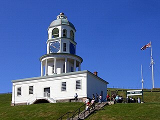
    The Halifax Peninsula is a community and planning area located in the urban core of municipal Halifax, Nova Scotia. Halifax Peninsula is home to Downtown Halifax, the financial and economic heart of the municipality, which was also the site of the original settlement and town of Halifax. The town of Halifax was founded by the British government under the direction of the Board of Trade and Plantations under the command of Governor Edward Cornwallis in 1749. Geographically, the Halifax Peninsula is a Canadian peninsula in central Nova Scotia.

    Halifax Regional Council

    Halifax Regional Council is the governing body of Halifax, known as the Halifax Regional Municipality (HRM). Halifax is governed by a mayor-council system, where councillors are elected from sixteen geographic districts though a first-past-the-post system and the mayor is elected via a municipality-wide first-past-the-post vote. Halifax Regional Council was formed in 1996 and consisted of twenty-three councillors and one mayor. It was reduced in size to sixteen councillors and the mayor in 2012. The council meets at Halifax City Hall.

    Downtown Halifax Downtown Area in Nova Scotia, Canada

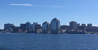
    Downtown Halifax is the primary central business district of Halifax, Nova Scotia. Located on the eastern-central portion of the Halifax Peninsula, on Halifax Harbour, it serves as the business, entertainment, and tourism hub of the region.

    The Eastern Shore is a region of the Canadian province of Nova Scotia. It is the Atlantic coast running northeast from Halifax Harbour to the eastern end of the peninsula at the Strait of Canso.

    History of Halifax (former city) Aspect of history

    Halifax, Nova Scotia, was originally inhabited by the Miꞌkmaq. The first European settlers to arrive in the future Halifax region were French, in the early 1600s, establishing the colony of Acadia. The British settled Halifax in 1749, which sparked Father Le Loutre's War. To guard against Miꞌkmaw, Acadian, and French attacks on the new Protestant settlements, British fortifications were erected in Halifax (1749), Bedford (1749), Dartmouth (1750), and Lawrencetown (1754). St. Margaret's Bay was first settled by French-speaking Foreign Protestants at French Village, Nova Scotia, who migrated from Lunenburg, Nova Scotia, during the American Revolution. All of these regions were amalgamated into the Halifax Regional Municipality (HRM) in 1996. While all of the regions of HRM developed separately over the last 250 years, their histories have also been intertwined.

    Musquodoboit Valley Valley in Nova Scotia, Canada

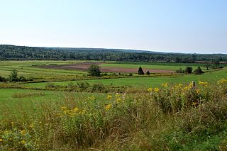
    The Musquodoboit Valley is a valley and region in the Halifax Regional Municipality of Nova Scotia, Canada. It is administratively located in the municipality's Musquodoboit Valley & Dutch Settlement planning area and the western edge of the valley includes communities that are considered part of the commutershed for the urban area of the Halifax Regional Municipality. The picturesque Musquodoboit River flows through majority of the valley, passing by most of the communities in the valley. The river is approximately 97 kilometres (60 mi) long and originates in the extreme northeastern area of the valley. The three largest communities in the valley are Upper Musquodoboit, Middle Musquodoboit and Musquodoboit Harbour. The word "Musquodoboit" is derived from the Mi’kmaq language and means "rolling out in foam".

    Middle Musquodoboit, Nova Scotia Place in Nova Scotia, Canada

    Middle Musquodoboit is a rural community in the Musquodoboit Valley region of Nova Scotia, Canada within the Halifax Regional Municipality, along the Musquodoboit River at the junction of Route 357 with Route 224, 78 kilometres (48 mi) from Dartmouth, Nova Scotia. The community's name comes from the First Nations' word Mooskoduboogwek, which means to suddenly widen out after a narrow entrance at a mouth. For a time after 1883, Middle Musquodoboit was called Laytonville, but at some point reverted to its former name.

    Musquodoboit Harbour, Nova Scotia Place in Nova Scotia, Canada

    Musquodoboit Harbour is a rural community located in Nova Scotia, Canada within the Halifax Regional Municipality. The community is situated on the Eastern Shore at the mouth of the Musquodoboit River. The community lies 45 kilometres east of downtown Halifax. With a hospital, RCMP detachment, postal outlet, schools, recreational center, library, municipal office and other services, Musquodoboit Harbour is a serve centre for many of the surrounding communities.

    Transportation in Halifax, Nova Scotia

    Halifax, Nova Scotia, is a major multi-modal transportation centre for freight and passengers in Atlantic Canada. Halifax, formally known as the Halifax Regional Municipality (HRM), is the capital and largest municipality of the Canadian province of Nova Scotia.

    The Halifax Regional Municipality (HRM) is a major generator of economic activity in Atlantic Canada.

    Gibraltar is a rural community of the Halifax Regional Municipality in the Canadian province of Nova Scotia on Nova Scotia Route 357, approximately 15 km north of Musquodoboit Harbour.

    Pockwock is one of four Black Nova Scotian settlements in Upper Hammonds Plains. People in this area are mostly descendants of War of 1812 refugees. It is located in the Halifax Regional Municipality in the Canadian province of Nova Scotia. The Halifax Regional Water Commission uses Pockwock Lake as a source for water for the communities of Halifax, Bedford and Lower Sackville.

    Outline of Nova Scotia Overview of and topical guide to Nova Scotia

    The following outline is provided as an overview of and topical guide to Nova Scotia:

    References

    1. "Census Profile, 2016 Census". Statistics Canada. Statistics Canada. Retrieved 5 February 2021.
    2. "Census Profile, 2016 Census". Statistics Canada. Statistics Canada. Retrieved 5 February 2021.
    3. 1 2 3 4 "Halifax Citadel, Nova Scotia". Canadian Climate Normals 1981–2010. Retrieved May 12, 2016.
    4. Station 44258 - Halifax Harbour
    5. "Shearwater A, Nova Scotia". Canadian Climate Normals 1981–2010. Retrieved May 12, 2016.
    6. "Monthly Data Report for 1871". Canadian Climate Data. Environment and Climate Change Canada. September 22, 2015. Retrieved 24 March 2016.
    7. "Daily Data Report for October 1930". Canadian Climate Data. Environment and Climate Change Canada. September 22, 2015. Retrieved 14 May 2016.
    8. "Monthly Data Report for 1939". Canadian Climate Data. Environment and Climate Change Canada. September 22, 2015. Retrieved 24 March 2016.
    9. "Daily Data Report for April 1945". Canadian Climate Data. Environment and Climate Change Canada. September 22, 2015. Retrieved 14 May 2016.
    10. "Halifax Dockyard". Canadian Climate Data. Environment and Climate Change Canada. September 22, 2015. Retrieved 24 March 2016.
    11. "Abstract of Meteorological register, Halifax, Nova Scotia, 1863" (PDF). Myers, W. J. (1867). Nova Scotian Institute of Science. 1867. Retrieved 4 September 2016.
    12. "Meteorological register, 1864" (PDF). Nova Scotian Institute of Science. 1867. Retrieved 4 September 2016.
    13. "Abstract of Meteorological register, Halifax, Nova Scotia, 1865" (PDF). Nova Scotian Institute of Science. 1867. Retrieved 4 September 2016.
    14. "Abstract of Meteorological register, Halifax, Nova Scotia, 1866" (PDF). Nova Scotian Institute of Science. 1867. Retrieved 4 September 2016.
    15. "Meteorological record, Halifax, Nova Scotia, 1867" (PDF). Nova Scotian Institute of Science. 1868. Retrieved 4 September 2016.
    16. "Meteorological summary, 1868" (PDF). Nova Scotian Institute of Science. 1869. Retrieved 4 September 2016.
    17. "On the meteorology of Halifax, 1870" (PDF). Allison, F. (1871). Nova Scotian Institute of Science. 1871. Retrieved 4 September 2016.
    18. "On the meteorology of Halifax, 1871" (PDF). Allison, F. (1872). Nova Scotian Institute of Science. 1872. Retrieved 4 September 2016.
    19. d.o.o, Yu Media Group. "Halifax, Canada - Detailed climate information and monthly weather forecast". Weather Atlas. Retrieved 2019-07-06.
    20. "Halifax Stanfield INT'L A, Nova Scotia". Canadian Climate Normals 1981–2010. Environment and Climate Change Canada. Archived from the original on May 9, 2014. Retrieved May 8, 2014.