The Andes, Andes Mountains or Andean Mountains are the longest continental mountain range in the world, forming a continuous highland along the western edge of South America. The range is 6,999 km (4,349 mi) long, 200 to 700 km wide, and has an average height of about 4,000 m (13,123 ft). The Andes extend from north to south through seven South American countries: Venezuela, Colombia, Ecuador, Peru, Bolivia, Chile, and Argentina.

The Republic of Colombia is situated largely in the northwest of South America, with some territories falling within the boundaries of Central America. It is bordered to the northwest by Panama; to the east by Venezuela and Brazil; to the south by Ecuador and Peru; and it shares maritime limits with Costa Rica, Nicaragua, Honduras, Jamaica, the Dominican Republic, and Haiti.

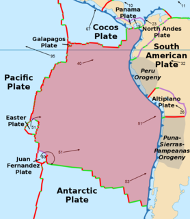
The Nazca Plate or Nasca Plate, named after the Nazca region of southern Peru, is an oceanic tectonic plate in the eastern Pacific Ocean basin off the west coast of South America. The ongoing subduction, along the Peru–Chile Trench, of the Nazca Plate under the South American Plate is largely responsible for the Andean orogeny. The Nazca Plate is bounded on the west by the Pacific Plate and to the south by the Antarctic Plate through the East Pacific Rise and the Chile Rise respectively. The movement of the Nazca Plate over several hotspots has created some volcanic islands as well as east-west running seamount chains that subduct under South America. Nazca is a relatively young plate both in terms of the age of its rocks and its existence as an independent plate having been formed from the break-up of the Farallon Plate about 23 million years ago. The oldest rocks of the plate are about 50 million years old.

The Andean Volcanic Belt is a major volcanic belt along the Andean cordillera in Argentina, Bolivia, Chile, Colombia, Ecuador, and Peru. It is formed as a result of subduction of the Nazca Plate and Antarctic Plate underneath the South American Plate. The belt is subdivided into four main volcanic zones which are separated by volcanic gaps. The volcanoes of the belt are diverse in terms of activity style, products, and morphology. While some differences can be explained by which volcanic zone a volcano belongs to, there are significant differences within volcanic zones and even between neighboring volcanoes. Despite being a type location for calc-alkalic and subduction volcanism, the Andean Volcanic Belt has a broad range of volcano-tectonic settings, as it has rift systems and extensional zones, transpressional faults, subduction of mid-ocean ridges and seamount chains as well as a large range of crustal thicknesses and magma ascent paths and different amounts of crustal assimilations.

Because of its natural structure, Colombia can be divided into six very distinct natural regions. These consist of the Andean Region, covering the three branches of the Andes mountains found in Colombia; the Caribbean Region, covering the area adjacent to the Caribbean Sea; the Pacific Region adjacent to the Pacific Ocean; the Orinoquía Region, part of the Llanos plains mainly in the Orinoco river basin along the border with Venezuela; the Amazon Region, part of the Amazon rainforest; and finally the Insular Region, comprising the islands in both the Atlantic and Pacific Oceans. Colombia is located in South America.

The geology of Chile is a characterized by processes linked to subduction such as volcanism, earthquakes and orogeny. The buildings blocks of Chile's geology assembled during the Paleozoic Era. Chile was by then the southwestern margin of the supercontinent Gondwana. In the Jurassic Gondwana began to split and the ongoing period of crustal deformation and mountain building known as the Andean orogeny began. In the Late Cenozoic Chile definitely separated from Antarctica, the Andes experienced a great rise accomplained by a cooling climate and the onset of glaciations.

The Venezuelan Andes also simply known as the Andes in Venezuela, are a mountain system that form the northernmost extension of the Andes. They are fully identified, both by their geological origin as by the components of the relief, the constituent rocks and the geological structure.

The Andean orogeny is an ongoing process of orogeny that began in the Early Jurassic and is responsible for the rise of the Andes mountains. The orogeny is driven by a reactivation of a long-lived subduction system along the western margin of South America. On a continental scale the Cretaceous and Oligocene were periods of re-arrangements in the orogeny. Locally the details of the nature of the orogeny varies depending on the segment and the geological period considered.

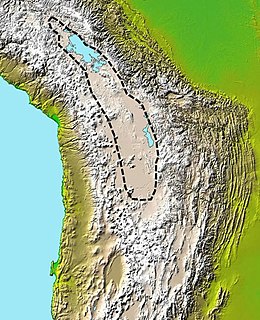
The geology of Bolivia comprises a variety of different lithologies as well as tectonic and sedimentary environments. On a synoptic scale, geological units coincide with topographical units. The country is divided into a mountainous western area affected by the subduction processes in the Pacific and an eastern lowlands of stable platforms and shields. The Bolivian Andes is divided into three main ranges; these are from west to east: the Cordillera Occidental that makes up the border to Chile and host several active volcanoes and geothermal areas, Cordillera Central once extensively mined for silver and tin and the relatively low Cordillera Oriental that rather than being a range by its own is the eastern continuation of the Central Cordillera as a fold and thrust belt. Between the Occidental and Central Cordillera the approximately 3,750-meter-high Altiplano high plateau extends. This basin hosts several freshwater lakes, including Lake Titicaca as well as salt-covered dry lakes that bring testimony of past climate changes and lake cycles. The eastern lowlands and sub-Andean zone in Santa Cruz, Chuquisaca, and Tarija Departments was once an old Paleozoic sedimentary basin that hosts valuable hydrocarbon reserves. Further east close to the border with Brazil lies the Guaporé Shield, made up of stable Precambrian crystalline rock.

The Atacama Fault Zone (AFZ) is an extensive system of faults cutting across the Chilean Coastal Cordillera in Northern Chile between the Andean Mountain range and the Pacific Ocean. The fault system is North-South striking and runs for more than 1100 km North and up to 50 km in width through the Andean forearc region. The zone is a direct result of the ongoing subduction of the Eastward moving Nazca Plate beneath the South American Plate and is believed to have formed in the Early Jurassic during the beginnings of the Andean orogeny. The zone can be split into 3 regions: the North, Central and South.

The geology of North America is a subject of regional geology and covers the North American continent, the third-largest in the world. Geologic units and processes are investigated on a large scale to reach a synthesized picture of the geological development of the continent.

The Altiplano Basin is a sedimentary basin within the Andes in Bolivia and Peru. The basin is located on the Altiplano plateau between the Cordillera Occidental and the Cordillera Oriental. Over-all the basin has evolved through time in a context of horizontal shortening of Earth's crust. The great thickness of the sediments accumulated in the basin is mostly the result of the erosion of Cordillera Oriental.
Jotabeche is a Miocene-Pliocene caldera in the Atacama Region of Chile. It is part of the volcanic Andes, more specifically of the extreme southern end of the Central Volcanic Zone (CVZ). This sector of the Andean Volcanic Belt contains about 44 volcanic centres and numerous more minor volcanic systems, as well as some caldera and ignimbrite systems. Jotabeche is located in a now inactive segment of the CVZ, the Maricunga Belt.

The Bucaramanga-Santa Marta Fault or Bucaramanga-Santa Marta Fault System is a major oblique transpressional sinistral strike-slip fault in the departments of Magdalena, Cesar, Norte de Santander and Santander in northern Colombia. The fault system is composed of two main outcropping segments, named Santa Marta and Bucaramanga Faults, and an intermediate Algarrobo Fault segment in the subsurface. The system has a total length of 674 kilometres (419 mi) and runs along an average north-northwest to south-southeast strike of 341 ± 23 from the Caribbean coast west of Santa Marta to the northern area of the Eastern Ranges of the Colombian Andes.

The Eastern Frontal Fault System is a megaregional system of oblique and thrust faults cross-cutting Colombia from Ecuador in the south to Venezuela in the north. The system from south to north covers ten out of 32 departments of Colombia; Nariño, Putumayo, Cauca, Huila, Caquetá, Cundinamarca, Meta, Boyacá, Casanare and Arauca. The Eastern Frontal Fault System underlies and affects the capitals of Putumayo, Mocoa, Caquetá, Florencia, Meta, Villavicencio and Casanare, Yopal. The fault system has a total length of 921.4 kilometres (572.5 mi) with a cumulative length of the faults of 1,821.8 kilometres (1,132.0 mi) and runs along an average northeast to southwest strike of 042.1 ± 19 bordering and crossing the Eastern Ranges of the Colombian Andes. The fault system forms the boundary between the North Andes microplate and the South American Plate.
The Romeral Fault System is a megaregional system of major parallel and anastomosing faults in the Central Ranges of the Colombian Andes and the Cauca, Amagá, and Sinú-San Jacinto Basins. The system spans across ten departments of Colombia, from northeast to south Bolívar, Sucre, Córdoba, Antioquia, Caldas, Risaralda, Quindío, Valle del Cauca, Cauca and Nariño. The fault zone extends into Ecuador where it is known as the Peltetec Fault System. The in detail described part of the Romeral Fault System south of Córdoba has a total length of 697.4 kilometres (433.3 mi) with a cumulative length of 1,787.9 kilometres (1,110.9 mi) and runs along an average north to south strike of 017.6 ± 16, cross-cutting the central-western portion of Colombia.
The Ibagué Fault is a major dextral slightly oblique strike-slip fault in the department of Tolima in central Colombia. The fault has a total length of 123.9 kilometres (77.0 mi) and runs along an average east-northeast to west-southwest strike of 067.9 ± 11 cross-cutting the Central Ranges of the Colombian Andes.

The geology of Peru includes ancient Proterozoic rocks, Paleozoic and Mesozoic volcanic and sedimentary rocks, and numerous basins and the Andes Mountains formed in the Cenozoic.

The Llanos Basin or Eastern Llanos Basin is a major sedimentary basin of 96,000 square kilometres (37,000 sq mi) in northeastern Colombia. The onshore foreland on Mesozoic rift basin covers the departments of Arauca, Casanare and Meta and parts of eastern Boyacá and Cundinamarca, western Guainía, northern Guaviare and southeasternmost Norte de Santander. The northern boundary is formed by the border with Venezuela, where the basin grades into the Barinas-Apure Basin.


