George Town, Cayman Islands

Last updated

George Town
96-124 S Church St, George Town, Cayman Islands - panoramio (1).jpg
Camana Bay skyline.jpg
Highway in George Town.jpg
Cayman Islands National Museum - George Town, Grand Cayman.jpg
George Town - Peace Memorial (3889750576).jpg
George Town Cayman Islands.jpg
Top: George Town skyline; top middle: Camana Bay, George Town Eastern Highway; Center: Camana Bay street; Bottom middle: National Museum, 1919 Peace Memorial; Bottom: George Town waterfront street
George Town KY Map.svg
Cayman Islands location map.svg
Red pog.svg
George Town
The location of George Town within the Cayman Islands
Caribbean location map.svg
Red pog.svg
George Town
George Town (Caribbean)
Coordinates: 19°18′12″N81°23′11″W / 19.3034°N 81.3863°W / 19.3034; -81.3863
CountryFlag of the United Kingdom.svg  United Kingdom
Overseas Territory Flag of the Cayman Islands.svg  Cayman Islands
Island Grand Cayman
Area
  Total29 km2 (11 sq mi)
Elevation
3 m (10 ft)
Population
 (2022) [1]
  Total40,957 [2]
Area code +1-345

George Town is the capital and largest city in the Cayman Islands, located on Grand Cayman. As of 2022, the city had a population of 40,957, [2] making it the largest city (by population) of all the British Overseas Territories. [1]

Contents

George Town is the heart of the Cayman Islands financial services industry (there are close to 600 Bank and Trust companies in the Cayman Islands). The Caymanian government offices are located in the city. According to the Globalization and World Cities Research Network in 2016, George Town is classed as a Beta city. [3]

Government

Cayman Islands flag flies at its foreign office Flag of Cayman Islands (28077880745).jpg
Cayman Islands flag flies at its foreign office

The Caymanian government offices are located in George Town. These offices include the Parliament of the Cayman Islands, the Court Houses and the Government Administration Building. The Government Administration Building houses the offices of the Premier and other members of Cabinet, the Deputy Governor and his staff as well as other elected officials and civil servants. The former Old Courts Building located at the corner of Shedden Road and Harbour Drive is now the National Museum of Grand Cayman. The building was built more than 150 years ago and has served the Caymanian government not only as a court building but as a jail and the island's first official Post Office.

The Cayman Islands are a British Overseas Territory, however, they are given special autonomy when dealing with domestic affairs. Foreign affairs are the responsibility of the British appointed Governor and the British Government. The British Army will also be called to defend or assist the islands in the event of a natural disaster or military conflict. It is also trusted that the United States would assist the islands in time of need if the UK requests, seeing that the US is closer in proximity to the islands than the UK.

Politics

The politics of George Town is dominated by the People's Progressive Movement, who won 5 out of the 7 electoral districts in the city during the 2021 general election. [4] They believe in introducing a nationwide welfare program, an increased financial presence in the UK, EU and US, reduced interference by the UK in domestic affairs and funding sustainable development projects across the islands. [5]

Demographics

Aerial view of George Town George Town Harbour.jpg
Aerial view of George Town
George Town’s residents by background [2]
Nationalitiespercent
Cayman Islands
37.9%
Jamaica
27.0%
The Philippines
8.1%
United Kingdom
7%
United States
5.3%
Canada
4.0%
Honduras
3.5%
India
2.7%
South Africa
1.5%
Nicaragua
1.1%
Ireland
1%
Other
0.9%

49.6% of the Cayman Islands population live in George Town. [2] It has recorded residents from more than one hundred countries. 37.9% of George Town's residents are Caymanian, and 63.8% are immigrants and permanent residents. The vast majority of the city's population are immigrants, mostly hailing from Jamaica, the Philippines, the United Kingdom, the United States, Canada, Honduras and India. There is also a growing South African population. [6]

Christianity is the most followed religion in the city, with most being Protestant with a sizable Catholic population. There is also a Jewish center and Islamic Society in the city.

Geography

George Town's city limits extend from the east at the edge of the South Shore District, north just beyond Owen Roberts International Airport, south to Hog Sty Bay and west to Seven Mile Beach and the West Bay District. George Town's famous Seven Mile Beach is a long crescent of coral-sand beach extending up to the West Bay region of Grand Cayman and is the most popular and populated area for tourists on the island. [7]

Climate

George Town has a tropical savanna climate (Köppen Aw), with a hot and wet season from May through November, and a very warm and dry season from December through April. As with most tropical climates, there is only a slight variation in monthly mean temperatures during the course of the year.

Climate data for George Town (Owen Roberts International Airport) 1981-2010, extremes 1971-2013
MonthJanFebMarAprMayJunJulAugSepOctNovDecYear
Record high humidex 39.242.643.343.545.443.845.544.844.844.143.143.145.5
Record high °C (°F)32.2
(90.0)
31.7
(89.0)
32.2
(90.0)
32.8
(91.0)
33.9
(93.0)
34.4
(94.0)
34.4
(94.0)
35.0
(95.0)
34.4
(94.0)
33.6
(92.4)
32.8
(91.0)
32.2
(90.0)
35.0
(95.0)
Mean daily maximum °C (°F)28.2
(82.8)
28.6
(83.4)
29.1
(84.3)
29.9
(85.9)
30.7
(87.3)
31.6
(88.9)
32.2
(89.9)
32.2
(89.9)
31.7
(89.0)
31.0
(87.8)
29.6
(85.2)
28.6
(83.5)
30.3
(86.5)
Daily mean °C (°F)25.8
(78.4)
26.1
(79.0)
26.6
(79.9)
27.6
(81.7)
28.5
(83.3)
29.2
(84.6)
29.6
(85.3)
29.7
(85.5)
29.3
(84.7)
28.5
(83.3)
27.5
(81.5)
26.2
(79.2)
27.9
(82.2)
Mean daily minimum °C (°F)22.3
(72.2)
22.4
(72.3)
22.7
(72.9)
23.7
(74.6)
24.7
(76.4)
25.5
(77.9)
25.7
(78.2)
25.6
(78.0)
25.3
(77.6)
24.7
(76.5)
24.1
(75.4)
23.2
(73.8)
24.2
(75.5)
Record low °C (°F)15.0
(59.0)
15.0
(59.0)
16.1
(61.0)
16.7
(62.0)
17.2
(63.0)
21.7
(71.0)
20.6
(69.0)
20.0
(68.0)
21.1
(70.0)
21.1
(70.0)
18.0
(64.4)
14.1
(57.3)
14.1
(57.3)
Average rainfall mm (inches)51.8
(2.04)
38.1
(1.50)
33.5
(1.32)
32.2
(1.27)
151.4
(5.96)
157.5
(6.20)
146.8
(5.78)
149.8
(5.90)
222.0
(8.74)
219.8
(8.65)
153.7
(6.05)
71.0
(2.80)
1,427.6
(56.21)
Average rainy days7664101212141615129123
Average relative humidity (%)76767575777877787979787877
Source 1: National Weather Service (Cayman Islands) [8]
Source 2: Weather In Cayman [9]
Climate data for George Town
MonthJanFebMarAprMayJunJulAugSepOctNovDecYear
Average sea temperature °C (°F)26.4
(79.5)
26.3
(79.3)
26.6
(79.9)
27.5
(81.5)
28.3
(82.9)
28.8
(83.8)
29.3
(84.7)
30.1
(86.2)
30.1
(86.2)
29.1
(84.4)
28.3
(82.9)
27.6
(81.7)
28.2
(82.8)
Mean daily daylight hours11.111.512.112.613.113.313.212.812.211.711.211.012.2
Average Ultraviolet index 81012121212121211108710.5
Source #1: seatemperature.org [10]
Source #2: Weather Atlas [11]

Economy

Finance

George Town Waterfront George Town - Old Harbor (3889750664).jpg
George Town Waterfront

The financial services generated CI$1.2 billion of GDP in 2007 (55% of the total economy), 36% of all employment and 40% of all government revenue. The Cayman Islands ranks fifth internationally in terms of value of liabilities booked and sixth in terms of assets booked. It has branches of 40 of the world's 50 largest banks. The Cayman Islands are the second largest captive domicile in the world with more than 700 captives, writing more than US$7.7 billion of premiums and with US$36.8 billion of assets under management. There are more than 9,500 funds under licence with globally recognised legal, audit/accounting and fund administration services[ citation needed ] (incl. the Big Four auditors [ citation needed ]). Major law firms such as Maples and Calder and Ogier (law firm) have established themselves in the Cayman Islands. Similarly, large accounting firms such as KPMG, PwC, Ernst & Young and Deloitte are also present. As a result, the Cayman Islands are a leader in captive domiciles, hedge fund registrations and is considered a major international banking centre.

Tourism

The Waterfront near Harbour House Waterfront, George Town, Grand Cayman.jpg
The Waterfront near Harbour House

George Town is a popular port of call for the Caribbean with cruise ships anchoring in George Town Harbour Tuesday through Friday. Cruise ships calling at George Town anchor offshore and ferry their passengers ashore by tenders, also known as shuttle boats. Passengers disembark in George Town, in the centre of the Grand Cayman shopping district and usually remain anchored from early morning until mid-afternoon.

Activities available to tourists in George Town include submarine tours of George Town Harbour, glass-bottom boat tours, snorkelling, scuba-diving, parasailing, charter boat tours, rum distillery tours, art galleries, a historical museum, and of course, shopping and eating. For nightlife, Seven Mile Beach is host to numerous nightclubs and bars. George Town's waterfront is also home to a Harley-Davidson shop, a Jimmy Buffett's Margaritaville franchise, and a Guy Harvey art studio and restaurant. The Kimpton Seafire Resort and Spa and The Ritz-Carlton Grand Cayman are the most expensive hotels on the island. [12]

Neighborhoods

Palm Trees on a Cayman Islands coastline Cayman Islands palms.jpg
Palm Trees on a Cayman Islands coastline

Spotts is a residential area south-east of George Town. It is famous for its Spotts Beach.

Red Bay is a residential area in east George Town. It has one primary school, Red Bay Primary School. George Town’s main highway from the east is located here.

Prospect is located to the east of George Town, as the city limits end. It is a residential area with one primary school, and a few convenience stores.

South Sound is a suburb to the south of the city and boasts some of the most expensive homes in the Cayman Islands. There are a few private schools, including St. Ignatius Catholic School, Cayman Prep High School, and Montessori, as well as a Government school, John Gray High School, and the University College of the Cayman Islands.

Downtown George Town is the center of the city's financial industry, and also houses the Parliament of the Cayman Islands and the main courthouse. With a surplus of banks and law firms, downtown is the center of the territory's business sector. George Town Primary School is also located here.

Whitehall Estates is a residential area north of Downtown George Town, near Seven Mile Beach.

Dog City is a residential area nearest to Downtown George Town and has a few shops and amenities.

Central George Town is the busiest area of the city, where most commuters will go through to get to other areas of the city. It is lined with shopping centers and the Cayman Islands Container Yard, which is operated by the Port Authority.

Windsor Park is a residential area in Central George Town with a few parks. Triple C School is located near this area.

Meegan Galeano Estates is a residential area near West Bay Road and is adjacent to Eastern Avenue

Industrial Park is to the north-east of George Town, where most of the island's factories and Government Ministries are located. Owen Roberts International Airport is operated here.

Tropical Gardens is a residential area south of Owen Roberts International Airport just off of Crewe Road.

Half Way Pond is a residential area near South Sound and has one school for both primary and middle school students, First Baptist Christian School.

Grand Harbour is just off of the main highway entering George Town from the east. It has a shopping center of the same name and an affluent residential area to the north.

Camana Bay acts as its own town north of George Town, but would still be included as a neighborhood of the city. It is a pedestrianized area with many shops and cafes, including a cinema, as well as apartment and office blocks. It has one private school, Cayman International School.

Seven Mile Beach is the center of the Cayman Islands tourism industry, and is lined with luxury hotels, condos, bars, clubs, shopping centers and boutiques. It has an overhead pedestrian path to Camana Bay. [13]

Transportation

Air

A 'welcome' sign at Owen Roberts International Airport, east of the city Welcome to the Cayman Islands - Owen Roberts International Airport, George Town, Grand Cayman.jpg
A 'welcome' sign at Owen Roberts International Airport, east of the city

George Town, as well as the rest of Grand Cayman, is served by nearby Owen Roberts International Airport. It is one of the only two entrance points to the Cayman Islands by air, the other being Charles Kirkconnell Airport on Cayman Brac.

There are over 55 weekly flights into the Cayman Islands. Cayman Airways is the National Flag Carrier of the Cayman Islands and features 3 Boeing 737 MAX 8 jets, 2 Saab B+ and two Twin Otters. Non-stop service to Grand Cayman are available from Atlanta, Chicago, Tampa, Newark, London, Toronto, New York, Montego Bay, Washington D.C., Havana, Miami, Panama City, La Ceiba and more. [14]

Road

Downtown George Town George Town, Cayman Islands - panoramio (1).jpg
Downtown George Town

The following highways serve the city:

Buses

A fleet of Share taxi minibuses serve the city. [15]

Education

The Cayman Islands Education Department operates George Town Primary School, Red Bay Primary School, Prospect Primary School, John Gray High School and the University College of the Cayman Islands.

John Gray High is in the former George Hicks High School building since 2012. [16]

Caymanian children are entitled to free primary and secondary education. Various churches and private foundations operate several private schools that offer American and British based studies starting from nursery up to A Levels and College. [17]

Private schools include:

The Montessori School also operates three schools in George Town. The schools are located on South Church Street, Hind's Way (off Walkers Road) and Prospect Point Road in Red Bay.

St. Matthew's University, a Medical and Veterinary school is located on the outskirts of George Town. [19]

Related Research Articles

<span class="mw-page-title-main">Cayman Islands</span> British Overseas Territory in the Caribbean

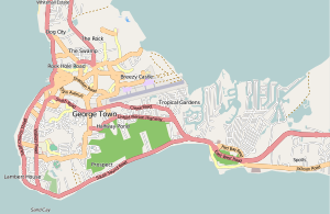
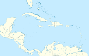
The CaymanIslands is a self-governing British Overseas Territory, and the largest by population. The 264-square-kilometre (102-square-mile) territory comprises the three islands of Grand Cayman, Cayman Brac and Little Cayman, which are located south of Cuba and north-east of Honduras, between Jamaica and Mexico's Yucatán Peninsula. The capital city is George Town on Grand Cayman, which is the most populous of the three islands.

This is a demography of the population of the Cayman Islands including population density, ethnicity, religious affiliations and other aspects of the population.

<span class="mw-page-title-main">Nassau, Bahamas</span> Capital and largest city of The Bahamas

Nassau is the capital and largest city of The Bahamas. It is located on the island of New Providence, which had a population of 246,329 in 2010, or just over 70% of the entire population of The Bahamas. As of April 2023, the preliminary results of the 2022 census of the Bahamas reported a population of 296,522 for New Providence, 74.26% of the country's population. Nassau is commonly defined as a primate city, dwarfing all other towns in the country. It is the centre of commerce, education, law, administration, and media of the country.

This article talks about transportation in the Bahamas, a North American archipelagic state in the Atlantic Ocean.

<span class="mw-page-title-main">Grand Cayman</span> Island in the Caribbean

Grand Cayman is the largest of the three Cayman Islands and the location of the territory's capital, George Town. In relation to the other two Cayman Islands, it is approximately 75 miles (121 km) southwest of Little Cayman and 90 miles (145 km) southwest of Cayman Brac.

<span class="mw-page-title-main">Kowloon Bay</span>

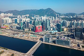
Kowloon Bay is a body of water within Victoria Harbour and an area within Kowloon, Hong Kong.

<span class="mw-page-title-main">Little Cayman</span> One of three Islands that make up the Cayman Islands

Little Cayman is one of three Islands that make up the Cayman Islands. It is located in the Caribbean Sea, approximately 60 miles (96 km) northeast of East End, Grand Cayman and five miles (8 km) west of West End, Cayman Brac. Little Cayman is the least populous island of the three, with a permanent population of about 160 (2021) including seasonal residents/homeowners. The majority of the population are expatriate workers from Jamaica, the Philippines, and Honduras and from other Latin American countries as well as Canada, the USA, India, Australia, Scotland, England, and South Africa. There are a handful of local Caymanians estimated as fewer than 20. It is about 10 miles (16 km) long with an average width of 1 mile (1600 m) and most of the island is undeveloped. Almost the entire island is at sea level. The highest elevation is about 40 feet. The rainy season, which consists of mostly light showers, occurs in Mid-April until June and again in mid-September to mid-October. There will be occasional quick rain showers in the early morning hours. The coolest months are from End of November until Mid March as the cold fronts coming in from the North which the temperature can drop into the low'70s. The Hottest and dryest months are in Summer starting mid-June to mid-September with temperatures between the mid-80s and high 90s. There are no large or predatory or venomous animals that pose a threat to humans.

<span class="mw-page-title-main">Yanbu</span> Place in Al Madinah, Saudi Arabia

Yanbu, also known simply as Yambu or Yenbo, is a city in the Al Madinah Province of western Saudi Arabia. It is approximately 300 kilometers northwest of Jeddah. The population is 331,916. Many residents are foreign expatriates working in the oil refineries and petrochemical industry, mostly from Asia, but there are also large numbers from the Middle East, Europe, and North America.

<span class="mw-page-title-main">Hung Hom</span> Area of Kowloon Peninsula, Hong Kong

Hung Hom is an area in the southeast of Kowloon Peninsula, Hong Kong. Including the area of Whampoa, Tai Wan, Hok Yuen, Lo Lung Hang and No. 12 Hill are administratively part of the Kowloon City District, with a portion west of Hung Hom Bay in the Yau Tsim Mong District. Hung Hom serves mainly residential purposes, but it is mixed with some industrial buildings in the north.

<span class="mw-page-title-main">Roatán</span> Largest of Honduras Bay Islands

Roatán is an island in the Caribbean, about 65 kilometres (40 mi) off the northern coast of Honduras. The largest of the Bay Islands of Honduras, it is located between the islands of Utila and Guanaja. The island was formerly known in English as Ruatan and Rattan.

Dunedin is a city of 134,600 people in the South Island of New Zealand. The principal suburbs of Dunedin are as follows. Inner and outer suburbs are ordered by location, clockwise from the city centre, starting due north:

<span class="mw-page-title-main">Grand Strand</span> Coastal area in South Carolina, US

The Grand Strand is an arc of beach land on the Atlantic Ocean in South Carolina, United States, extending more than 60 miles (97 km) from Little River to Winyah Bay. It is located in Horry and Georgetown Counties on the NE South Carolina coast.

<span class="mw-page-title-main">Providenciales</span> Island and the largest city of Turks and Caicos Islands

Providenciales is an island in the northwest Caicos Islands, part of the Turks and Caicos Islands, a British Overseas Territory. The island has an area of 98 km2 (38 sq mi) and a 2012 Census population of 23,769. Providenciales is the third largest island in the Turks and Caicos in area, and is home to a large majority of the population of the Turks and Caicos Islands.

<span class="mw-page-title-main">Seven Mile Beach, Grand Cayman</span>

Seven Mile Beach (SMB) is a long crescent of coral-sand beach on the western end of Grand Cayman island. Seven Mile Beach is known for its beauty, receiving the honor of "The Caribbean's Best Beach" in 2015 from Caribbean Travel and Life Magazine. It is public property and one is able to walk the full length of the beach, regardless of where you are staying. The Seven Mile Beach is the most popular and most developed area of Grand Cayman. It is home to the majority of the island's luxury resorts and hotels. Despite the name, a generous measurement puts the actual length at just a bit over 6.3 miles (10.1 km) long. A realistic length for the uninterrupted sandy beach is about 6 miles. The beach falls victim to annual erosion, which has reduced its size in some areas, and may have reduced its length at the ends. Like the rest of Grand Cayman, the development around the Seven Mile Beach was severely damaged in Hurricane Ivan in September 2004 but many condominiums & hotels are still running at full capacity.

<span class="mw-page-title-main">Bodden Town (village)</span> Village in Cayman Islands

Bodden Town is the former capital of the Cayman Islands and the largest district in the territory. It is situated on a natural harbour and a coral reef. The first settlement was named after a government leader, William Bodden. Once ravaged by pirates, this village is known for its remains of a 4 mi (6 km) wall and cannon. Bodden Town has a population of 14,845. Its top attractions include the Mission House, which features the lifestyle of early Caymanian settlers. Bodden Town is also considered the fastest growing district in the islands in terms of resident population.

West Bay is a district located on the west side of the British Overseas Territory of the Cayman Islands in the Caribbean. The population is 15,335.

<span class="mw-page-title-main">Grand Promenade</span> Housing estate in Sai Wan Ho, Hong Kong

The Grand Promenade is a high-rise residential development located at 38 Tai Hong Street, Sai Wan Ho, Hong Kong Island, Hong Kong. It is developed by Henderson Land Development and its subsidiary, The Hongkong and Yaumati Ferry Co Ltd. in 2005.

<span class="mw-page-title-main">Great Brak River (town)</span> Place in Western Cape, South Africa

Great Brak River is a coastal village in the Mossel Bay Local Municipality in the Western Cape province of South Africa. It is a historic village built around the lagoon of the Great Brak River, 17 kilometres (11 mi) north-northeast of the town of Mossel Bay.

Cayman International School (CIS) is a private school in Camana Bay, George Town, Grand Cayman, Cayman Islands. It is operated by International Schools Services (ISS) and serves levels nursery through grade 12. It has a 21-acre (8.5 ha) campus.

<span class="mw-page-title-main">Korora, New South Wales</span> Suburb of Coffs Harbour, New South Wales, Australia

Korora is a suburb of the City of Coffs Harbour in New South Wales, Australia, located 6 km north of the city centre. Korora is located in a basin that runs from the foothills of the Great Dividing Range in the west to Korora Bay in the east. It is bisected by the Pacific Highway, which runs south to north between Sydney and Brisbane. The section of Korora between the Pacific Highway and the coast is mainly residential, with some tourist facilities. The section west of the Highway consists of larger residential blocks and farms growing mainly bananas and blueberries. The west-most section of Korora is forested and includes part of the Ulidarra National Park. The Korora basin is drained by creeks that flow into Pine Brush Creek and enter the sea at Hills Beach.

References

  1. 1 2 "About Cayman" (PDF). Gov.ky. 24 September 2013. Retrieved 5 October 2013.
  2. 1 2 3 4 Cayman Islands’ 2021 Census Report Archived 31 March 2022 at the Wayback Machine
  3. "The World According to GaWC 2016". GaWC. 24 April 2017. Retrieved 15 June 2017.
  4. "Cayman Islands Districts Election Results".
  5. Manifesto 2021 [ dead link ]
  6. "Moving to Cayman Islands | Expat Arrivals".
  7. "Beaches in Grand Cayman | Frommer's". Frommers.com. Retrieved 23 August 2018.
  8. "Cayman Data Table". Meteorological Service (Jamaica). Archived from the original on 29 September 2018. Retrieved 22 September 2016.
  9. "Weather In Cayman". Weather In Cayman. Retrieved 22 December 2018.
  10. "George Town Sea Temperature". seatemperature.org. Retrieved 19 December 2018.
  11. "George Town, Cayman Islands - Climate data". Weather Atlas. Retrieved 24 January 2019.
  12. Expedia research
  13. "Neighbourhoods of the Cayman Islands".
  14. "Get to Cayman by Air – Cayman Island Flights". Cayman Islands. Archived from the original on 18 March 2015. Retrieved 5 October 2013.
  15. "Grand Cayman's Public Bus Service". Grandcayman4u.com. Archived from the original on 12 October 2013. Retrieved 5 October 2013.
  16. "New School Year Begins – Clifton Hunter High School Opens!" Cayman iEyenews. August 29, 2012. Retrieved on September 15, 2016.
  17. "Education". Cayman Islands Government. Retrieved 3 December 2013.
  18. "Youth Service Providers Directory." Government of the Cayman Islands. Retrieved on September 15, 2016. p. 27/64. "St. Ignatius Catholic School Physical Location: 599 Walkers Road District: George Town"
  19. "A Grand Cayman Island Tour: Today and in History". Grand-cayman-wanderer.com. 24 September 2013. Archived from the original on 14 July 2007. Retrieved 5 October 2013.

Commons-logo.svg Media related to George Town, Cayman Islands at Wikimedia Commons